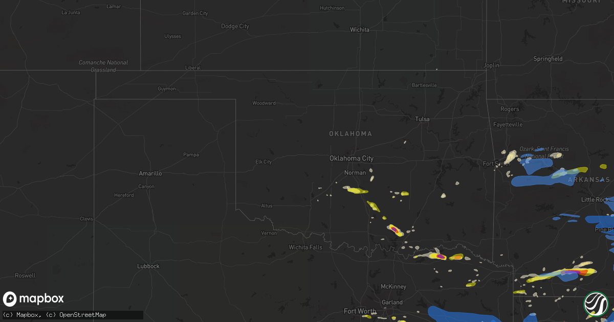
Hail Map in Oklahoma on April 12, 2020
Get this storm
April 12 map
$229
one time, instant access
Download today. No call, no setup
Keep the $229
Bought the map and want the full workflow? Apply the entire $229 to a subscription within 7 days. None of it is wasted.
Every map, not just this one
This buys you this map. Subscription and you get every map we run, in the markets you choose from a few cities to whole states to nationwide. Plus real-time alerts the moment a storm fires.
Contact data
Name, contact info, occupancy, even credit band for addresses in the footprint. You go from where it hit to who to call.
Become the source they trust
Unlimited branding weather history reports on demand. You already have the documented answer ready for the property owner, and you are the one who showed up with it.
Property data and RoofTrace estimates
Pull up any address you have got, its value and the exact code rules for that jurisdiction, straight from One Click Code. Then RoofTrace estimates the squares, pitch, and roof value, priced the way you price.
Storm reports in Oklahoma
Oklahoma
| Date | Description |
|---|---|
| 04/12/20205:15 PM CDT | 57.5 mph at cloudy mesonet |
| 04/12/20204:34 PM CDT | A local report indicates 1.75 inch wind near 3 S MILBURN |
| 04/12/20204:32 PM CDT | A local report indicates 1.00 inch wind near 6 E TISHOMINGO |
| 04/12/20204:22 PM CDT | A local report indicates 1.00 inch wind near 4 N TISHOMINGO |
| 04/12/20204:18 PM CDT | Roof shingle damage. Power poles downed. |
| 04/12/20203:50 PM CDT | Ranged from pea to quarter size hail. |
| 04/12/20203:08 PM CDT | A local report indicates 1.00 inch wind near 4 E ADA |
| 04/12/20202:40 PM CDT | Facebook picture relayed by broadcast media. |
| 04/12/20207:08 AM CDT | At 1207 AM CDT, severe thunderstorms were located along a line extending from the east side of Ardmore to 3 miles south of Overbrook, moving east at 40 mph. HAZARD...60 mph wind gusts and penny size hail. SOURCE...Radar indicated. IMPACT...Expect damage to roofs, siding, and trees. Locations impacted include... Ardmore, Madill, Tishomingo, Marietta, Kingston, Dickson, Mannsville, Ravia, Milburn, Gene Autry, Overbrook, Fillmore, Woodville, Lake Murray, Lebanon, Russett, Coleman, Little City, Nida and northern Lake Texoma. |
| 04/12/20201:24 AM CDT | At 624 PM CDT, a severe thunderstorm was located 7 miles east of Gillham, or 9 miles southwest of Umpire, moving east at 35 mph. HAZARD...60 mph wind gusts and quarter size hail. SOURCE...Radar indicated. IMPACT...Hail damage to vehicles is expected. Expect wind damage to roofs, siding, and trees. Locations impacted include... De Queen, Nashville, Mineral Springs, Dierks, Horatio, Umpire, Lockesburg, Winthrop, Gillham, Ben Lomond, Corinth, Center Point, Athens, Oak Grove, Silver Ridge, Geneva, Central, Muddy Fork, Provo and West Line. |
| 04/12/202012:49 AM CDT | At 549 PM CDT, a severe thunderstorm was located near Hooks, or near New Boston, moving northeast at 40 mph. HAZARD...60 mph wind gusts and quarter size hail. SOURCE...Radar indicated. IMPACT...Hail damage to vehicles is expected. Expect wind damage to roofs, siding, and trees. Locations impacted include... Texarkana, Wake Village, Ashdown, New Boston, Nash, Hooks, De Kalb, Redwater, Maud, Red Lick, Wilton, Ogden, Mandeville, Genoa, Dalby Springs, Richmond, Leary, Douglassville, Marietta and Domino. |
| 04/11/202011:55 PM CDT | At 454 PM CDT, a severe thunderstorm was located near Wilkerson, or 7 miles south of Boxelder, moving northeast at 25 mph. HAZARD...60 mph wind gusts and half dollar size hail. SOURCE...Radar indicated. IMPACT...Hail damage to vehicles is expected. Expect wind damage to roofs, siding, and trees. Locations impacted include... Mount Pleasant, New Boston, Boxelder, De Kalb, Maud, Us 259 And I 30 Intersection, Wilkerson, Dalby Springs, Winfield, Talco, Miller's Cove, Spring Hill, Harts Bluff, Lydia and Almont. |
| 04/11/202011:28 PM CDT | At 428 PM CDT, a severe thunderstorm was located near Milburn, moving southeast at 25 mph. HAZARD...60 mph wind gusts and quarter size hail. SOURCE...Radar indicated. IMPACT...Hail damage to vehicles is expected. Expect wind damage to roofs, siding, and trees. Locations impacted include... Durant, Tishomingo, Caddo, Silo, Milburn, Kenefic, Armstrong, Nida, northeastern Lake Texoma and Calera. |
| 04/11/202011:10 PM CDT | At 409 PM CDT, a severe thunderstorm was located 13 miles northeast of Honey Grove, or 16 miles northwest of Paris, moving east at 25 mph. A second severe thunderstorm capable of producing quarter size hail may impact northern Fannin County. HAZARD...Half dollar size hail. SOURCE...Radar indicated. IMPACT...Damage to vehicles is possible. Locations impacted include... Paris, Blossom and Sun Valley. |
| 04/11/202011:08 PM CDT | At 408 PM CDT, a severe thunderstorm was located near Mill Creek, moving east at 30 mph. HAZARD...60 mph wind gusts and quarter size hail. Hail may cover the ground. SOURCE...Radar indicated. IMPACT...Hail damage to vehicles is expected. Expect wind damage to roofs, siding, and trees. Locations impacted include... Wapanucka, Mill Creek, Milburn, Bromide, Connerville, Pontotoc, Clarita, Coleman, Fillmore and Reagan. |
| 04/11/202010:51 PM CDT | At 351 PM CDT, a severe thunderstorm was located 4 miles northeast of Achille, moving east at 25 mph. HAZARD...60 mph wind gusts and quarter size hail. SOURCE...Radar indicated. IMPACT...Hail damage to vehicles is expected. Expect wind damage to roofs, siding, and trees. Locations impacted include... Durant, Bokchito, Achille, Utica, Albany, Blue, Calera and Wade. |
| 04/11/202010:30 PM CDT | At 330 PM CDT, a severe thunderstorm was located 7 miles east of Wynnewood, moving east at 20 mph. HAZARD...60 mph wind gusts and quarter size hail. SOURCE...Radar indicated. IMPACT...Hail damage to vehicles is expected. Expect wind damage to roofs, siding, and trees. Locations impacted include... Sulphur, Davis, Roff, Fitzhugh, Hickory, Scullin and Lake Of The Arbuckles. |
| 04/11/202010:17 PM CDT | At 317 PM CDT, a severe thunderstorm was located near Allen, moving east at 20 mph. Another severe storm was located 7 miles southwest of Allen. HAZARD...Quarter size hail. SOURCE...Radar indicated. IMPACT...Damage to vehicles is expected. Locations impacted include... Allen, Stuart and Gerty. |
| 04/11/202010:17 PM CDT | At 317 PM CDT, a severe thunderstorm was located 9 miles northeast of Ravenna, or 10 miles northeast of Bonham, moving east at 20 mph. HAZARD...60 mph wind gusts and half dollar size hail. SOURCE...Radar indicated. IMPACT...Hail damage to vehicles is expected. Expect wind damage to roofs, siding, and trees. Locations impacted include... Toco. |
| 04/11/20209:36 PM CDT | At 236 PM CDT, a severe thunderstorm was located near Criner, moving east at 25 mph. HAZARD...60 mph wind gusts and quarter size hail. SOURCE...Radar indicated. IMPACT...Hail damage to vehicles is expected. Expect wind damage to roofs, siding, and trees. Locations impacted include... Purcell, Slaughterville, Lexington, Dibble, Wayne, Washington, Rosedale, Criner and Payne. |
All States Impacted by Hail Map on April 12, 2020
Cities Impacted by Hail Map on April 12, 2020
- Rayville, LA
- Epps, LA
- Pioneer, LA
- Delhi, LA
- Monroe, LA
- Burkeville, TX
- Boaz, AL
- Pinola, MS
- Magee, MS
- Mendenhall, MS
- Raleigh, MS
- McRae Helena, GA
- Milan, GA
- Covington, LA
- Springfield, LA
- Robert, LA
- Ponchatoula, LA
- Folsom, LA
- Loranger, LA
- Hammond, LA
- Deridder, LA
- Rocky Ford, GA
- Sylvania, GA
- Kilgore, TX
- Longview, TX
- Gordo, AL
- Knoxville, AL
- Aliceville, AL
- Eutaw, AL
- Ralph, AL
- Mountainburg, AR
- Rudy, AR
- Alma, AR
- Roxton, TX
- Hardeeville, SC
- Henderson, TX
- Colquitt, GA
- Gonzales, LA
- Baton Rouge, LA
- Prairieville, LA
- Douglass, TX
- Allen, OK
- Noxapater, MS
- Louisville, MS
- Sikes, LA
- Cameron, TX
- Merryville, LA
- Lumberton, MS
- Purvis, MS
- Saint Martinville, LA
- New Iberia, LA
- Jeanerette, LA
- Loreauville, LA
- Hampton, AR
- Kosciusko, MS
- Pickens, MS
- Lexington, MS
- Durant, MS
- Columbia, LA
- Grayson, LA
- Pelsor, AR
- Dover, AR
- Wanette, OK
- Macomb, OK
- Berry, AL
- Echola, AL
- Elrod, AL
- Northport, AL
- El Dorado, AR
- West Monroe, LA
- Eros, LA
- Chatham, LA
- Calipatria, CA
- Stuttgart, AR
- Troy, AL
- Gallant, AL
- Altoona, AL
- Attalla, AL
- Davis, OK
- Wynnewood, OK
- Fort Smith, AR
- Watson, AR
- Monticello, AR
- Statesboro, GA
- Winnfield, LA
- Peterman, AL
- Coushatta, LA
- Pineland, SC
- Frankston, TX
- Brantley, AL
- Louann, AR
- Camden, AR
- Trion, GA
- Summerville, GA
- Palestine, TX
- Crockett, TX
- Grapeland, TX
- Walker, LA
- Dacula, GA
- Braselton, GA
- Auburn, GA
- Buford, GA
- Lawrenceville, GA
- Flowery Branch, GA
- Hoschton, GA
- McLain, MS
- Perkinston, MS
- Bogalusa, LA
- Carrollton, AL
- Buhl, AL
- Fayette, AL
- Reform, AL
- Coker, AL
- Kennedy, AL
- Shelbyville, TX
- Brandon, MS
- Ridgeland, MS
- Madison, MS
- Jackson, MS
- Maysville, OK
- Lindsay, OK
- Satartia, MS
- Center, TX
- Newellton, LA
- Tallulah, LA
- Saline, LA
- Jonesboro, LA
- Goldonna, LA
- Clayton, AL
- Eufaula, AL
- Shorterville, AL
- Abbeville, AL
- Clopton, AL
- Timpson, TX
- Cushing, TX
- Rusk, TX
- Alto, TX
- Smithdale, MS
- Liberty, MS
- Harrisville, MS
- Braxton, MS
- Sorrento, LA
- Kennard, TX
- Wayne, OK
- Purcell, OK
- Harrisonburg, LA
- Calhoun, LA
- Natchitoches, LA
- Lewisville, AR
- Desoto, TX
- Lancaster, TX
- Dallas, TX
- Duncanville, TX
- Cedar Hill, TX
- Flint, TX
- Tyler, TX
- Whitehouse, TX
- Thomasville, AL
- Clayton, LA
- Detroit, TX
- Bagwell, TX
- Steele, AL
- Remlap, AL
- Oneonta, AL
- Flora, MS
- Scurry, TX
- Kaufman, TX
- Colfax, LA
- Ratcliff, AR
- Ozark, AR
- Downsville, LA
- Farmerville, LA
- Elkhart, TX
- Tuscumbia, AL
- Talco, TX
- Seagoville, TX
- Ferris, TX
- Arnaudville, LA
- Sallis, MS
- Wills Point, TX
- Terrell, TX
- Franklinton, LA
- McNeil, AR
- Buckner, AR
- Waldo, AR
- Banks, AR
- Stamps, AR
- Stephens, AR
- Blossom, TX
- Pine Valley, CA
- Campo, CA
- Boulevard, CA
- Calvin, OK
- Bay Springs, MS
- Heidelberg, MS
- Laurel, MS
- Pinson, AL
- Morris, AL
- Cleveland, AL
- Mount Olive, AL
- Trafford, AL
- Locust Fork, AL
- Gardendale, AL
- Graysville, AL
- Poplarville, MS
- Ohatchee, AL
- Paris, TX
- Sumner, TX
- Nacogdoches, TX
- Tenaha, TX
- Mount Enterprise, TX
- Gary, TX
- Carthage, TX
- Garrison, TX
- Laughlin, NV
- Searchlight, NV
- Scooba, MS
- Hartshorne, OK
- Collins, MS
- Texarkana, AR
- Fouke, AR
- Sulphur, OK
- Canton, MS
- Dardanelle, AR
- Pottsville, AR
- Russellville, AR
- Atkins, AR
- Mount Pleasant, TX
- Tifton, GA
- Enigma, GA
- Buckholts, TX
- Wells, TX
- Clarksville, TX
- Cecil, AR
- Highland Home, AL
- Goshen, AL
- Luverne, AL
- Grady, AL
- Rutledge, AL
- Donaldsonville, LA
- Belle Rose, LA
- Plattenville, LA
- Fort Scott, KS
- Uniontown, KS
- Taylor, AR
- Mer Rouge, LA
- Bastrop, LA
- Kenefic, OK
- Durant, OK
- Bassfield, MS
- Prentiss, MS
- Estill, SC
- Millen, GA
- Garfield, GA
- Tishomingo, OK
- Milburn, OK
- Ashdown, AR
- McGehee, AR
- Tillar, AR
- Troup, TX
- Metter, GA
- Kaplan, LA
- Lamar, AR
- White Oak, TX
- Gladewater, TX
- Trout, LA
- Abbeville, GA
- Eastman, GA
- McCool, MS
- Philadelphia, MS
- Preston, MS
- Brooksville, MS
- Macon, MS
- Shuqualak, MS
- Claxton, GA
- Woodville, MS
- Samson, AL
- Kinston, AL
- Olla, LA
- Haughton, LA
- Benton, LA
- Collins, GA
- Lyons, GA
- Mulberry, AR
- Dyer, AR
- Booneville, AR
- Greenwood, AR
- Robeline, LA
- Holden, LA
- Livingston, LA
- French Settlement, LA
- De Kalb, TX
- Avery, TX
- Brookston, TX
- Honey Grove, TX
- Arthur City, TX
- Mapleton, KS
- Altheimer, AR
- Wabbaseka, AR
- Silver City, MS
- Alex, OK
- Blanchard, OK
- Jacksonville, TX
- Leakesville, MS
- Guild, TN
- Trenton, GA
- Ethelsville, AL
- Edwards, MS
- Starkville, MS
- Lena, MS
- Camden, MS
- Bolton, MS
- Morton, MS
- Oakman, AL
- Raymond, MS
- Columbus, MS
- Clinton, MS
- Carthage, MS
- Crawford, MS
- Tuscaloosa, AL
- Arlington, TX
- Kennedale, TX
- Fort Worth, TX
- Scott, LA
- Lafayette, LA
- Carencro, LA
- Duson, LA
- Breaux Bridge, LA
- Rayne, LA
- Morse, LA
- Gueydan, LA
- Crowley, LA
- Magnolia, MS
- Pollock, LA
- Dry Prong, LA
- Georgetown, LA
- Tullos, LA
- Millport, AL
- Lake Providence, LA
- Opp, AL
- Dickinson, AL
- Grove Hill, AL
- Vicksburg, MS
- Garland, KS
- Farlington, KS
- Arcadia, KS
- Red Oak, OK
- Carnesville, GA
- Boulder City, NV
- Muscle Shoals, AL
- Haynesville, LA
- Junction City, AR
- Quincy, FL
- Ramer, AL
- Port Allen, LA
- Apison, TN
- McDonald, TN
- Cleveland, TN
- Tupelo, OK
- Ridgeland, SC
- Carville, LA
- Geismar, LA
- Maurepas, LA
- Saint Gabriel, LA
- Albany, LA
- Denham Springs, LA
- Saint Amant, LA
- White Castle, LA
- Independence, LA
- Tickfaw, LA
- Carson, MS
- Seminary, MS
- Taylorsville, MS
- Bullard, TX
- Lowndesboro, AL
- Glenwood, AL
- Powderly, TX
- Silver Creek, MS
- Campti, LA
- Florala, AL
- Rush Springs, OK
- Fosters, AL
- Atoka, OK
- Bay Saint Louis, MS
- Stennis Space Center, MS
- Cataula, GA
- Twin City, GA
- Springville, AL
- Kimberly, AL
- Warrior, AL
- Birmingham, AL
- Portal, GA
- Mansfield, LA
- Pelican, LA
- Chauncey, GA
- Amite, LA
- Greensburg, LA
- Pine Grove, LA
- Humphrey, AR
- Bennington, OK
- Bokchito, OK
- Converse, LA
- Letohatchee, AL
- Hayneville, AL
- Benton, MS
- Tishomingo, MS
- Dennis, MS
- Ada, OK
- Grand Chenier, LA
- Maurice, LA
- Bradley, SC
- Rainbow City, AL
- Mayersville, MS
- Rolling Fork, MS
- Calion, AR
- Darrow, LA
- Townley, AL
- Marshallville, GA
- Booneville, MS
- Nauvoo, AL
- Shelby, MS
- Calera, OK
- Hendrix, OK
- Greenville, AL
- Mccomb, MS
- Tylertown, MS
- Summit, MS
- Jayess, MS
- Ruth, MS
- Oakwood, TX
- West, MS
- Vaiden, MS
- Tennille, GA
- Garnett, SC
- Clinton, LA
- Norwood, LA
- Hayden, AL
- Marthaville, LA
- Vaughan, MS
- Choudrant, LA
- Springer, OK
- Springfield, AR
- Hattieville, AR
- Solgohachia, AR
- Morrilton, AR
- Caddo, OK
- Lucedale, MS
- Wiggins, MS
- Doddridge, AR
- Sulphur Springs, TX
- Early Branch, SC
- Varnville, SC
- Fitzpatrick, AL
- Hattiesburg, MS
- Emerson, AR
- Hope Hull, AL
- Prattville, AL
- Montgomery, AL
- Bullhead City, AZ
- Rossville, GA
- Ringgold, GA
- Fort Oglethorpe, GA
- Singer, LA
- Sondheimer, LA
- La Place, LA
- Bradley, AR
- Harrell, AR
- Jersey, AR
- Garland City, AR
- Rosston, AR
- Thornton, AR
- Ozark, AL
- Skipperville, AL
- Rochelle, GA
- McCune, KS
- Houston, MS
- McIntyre, GA
- Toomsboro, GA
- Ivanhoe, TX
- Ravenna, TX
- Madill, OK
- Fort Valley, GA
- Chattanooga, TN
- Chickasha, OK
- Tillman, SC
- Altus, AR
- Clarksville, AR
- Adger, AL
- Albertville, AL
- Mulga, AL
- Quinton, AL
- Horton, AL
- Dawson, AL
- Crossville, AL
- Brookside, AL
- Bessemer, AL
- Adamsville, AL
- Blountsville, AL
- Geraldine, AL
- Dora, AL
- Ashville, AL
- Lincoln, AL
- Anniston, AL
- Brawley, CA
- Pembroke, GA
- Buckatunna, MS
- Millry, AL
- State Line, MS
- Yazoo City, MS
- Mound Valley, KS
- Parsons, KS
- Wilburton, OK
- Cherokee, AL
- Pollok, TX
- Ethel, MS
- Bentonia, MS
- Perry, GA
- Picayune, MS
- Lavaca, AR
- Carriere, MS
- Humnoke, AR
- Gadsden, AL
- Cooper, TX
- Marietta, TX
- Douglassville, TX
- Naples, TX
- Lapine, AL
- Honoraville, AL
- Sardis, MS
- Jackson, AL
- Sunflower, AL
- Leroy, AL
- McIntosh, AL
- Deer Park, AL
- Gainestown, AL
- Wagarville, AL
- Pearl River, LA
- Altamont, KS
- Chatom, AL
- Beaumont, MS
- Gaylesville, AL
- Odenville, AL
- Goodman, MS
- Gilbert, LA
- Winnsboro, LA
- Mathews, AL
- Tougaloo, MS
- Enterprise, LA
- Fort Gaines, GA
- Elba, AL
- Valley Park, MS
- Register, GA
- Annona, TX
- Hampton, SC
- Coffeyville, KS
- Jesup, GA
- McKenzie, AL
- Red Level, AL
- Springhill, LA
- Soperton, GA
- Swainsboro, GA
- Bristow, OK
- Oak Grove, LA
- Natchez, LA
- Cloutierville, LA
- Montgomery, LA
- Hornbeck, LA
- Plain Dealing, LA
- Oak Ridge, LA
- Fort Necessity, LA
- Lena, LA
- Atlanta, LA
- Beatrice, AL
- Vredenburgh, AL
- Pocola, OK
- Hartman, AR
- Coal Hill, AR
- Arp, TX
- Winona, TX
- Sumrall, MS
- Soso, MS
- Mount Olive, MS
- Dalton, GA
- Oak Vale, MS
- Baker, LA
- Greenwell Springs, LA
- Zachary, LA
- Pride, LA
- Petersburg, TX
- Slaughter, LA
- Cement, OK
- Anadarko, OK
- Mill Creek, OK
- Homer, GA
- Transylvania, LA
- Cary, MS
- Fletcher, OK
- Elgin, OK
- Duncan, MS
- Snow Lake, AR
- Mangham, LA
- Baskin, LA
- Caney, OK
- Mcloud, OK
- Tecumseh, OK
- Chatsworth, GA
- Cookville, TX
- Crandall, TX
- Charleston, AR
- Nettleton, MS
- Okolona, MS
- Shannon, MS
- Plantersville, MS
- Fulton, MS
- England, AR
- Westmorland, CA
- Minden, LA
- Ruleville, MS
- Tucker, AR
- Carbon Hill, AL
- Eldridge, AL
- Bankston, AL
- Seabrook, SC
- Springfield, GA
- Kiln, MS
- Slidell, LA
- Monticello, MS
- Richton, MS
- Telephone, TX
- La Fayette, GA
- Neely, MS
- Brooklyn, MS
- Sicily Island, LA
- Eastaboga, AL
- Pell City, AL
- Riverside, AL
- Ragland, AL
- Grand Prairie, TX
- Monroeville, AL
- Franklin, AL
- Deport, TX
- Pattonville, TX
- Paoli, OK
- Fort Payne, AL
- Collinsville, AL
- Price, TX
- Delaware, AR
- Knoxville, AR
- London, AR
- Magazine, AR
- Paris, AR
- Scranton, AR
- New Blaine, AR
- Subiaco, AR
- Danville, AR
- Casa, AR
- Waldron, AR
- Houston, AR
- Blue Mountain, AR
- Belleville, AR
- Perry, AR
- Perryville, AR
- Havana, AR
- Ola, AR
- Plumerville, AR
- Adona, AR
- Magnolia, AR
- Smackover, AR
- Mount Holly, AR
- Hot Springs National Park, AR
- Malvern, AR
- Traskwood, AR
- Ozone, AR
- El Paso, AR
- Vilonia, AR
- Potts Camp, MS
- Grady, AR
- Coahoma, MS
- Thaxton, MS
- Sledge, MS
- Marks, MS
- Ethel, AR
- Batesville, MS
- Pine Bluff, AR
- Holly Springs, MS
- Nesbit, MS
- Senatobia, MS
- Etta, MS
- Almyra, AR
- Myrtle, MS
- Lyon, MS
- Ashland, MS
- Saint Charles, AR
- Clarksdale, MS
- Waterford, MS
- Holly Grove, AR
- Olive Branch, MS
- Hickory Flat, MS
- Courtland, MS
- Mellwood, AR
- Lambert, MS
- Gillett, AR
- University, MS
- Abbeville, MS
- Blue Mountain, MS
- Crenshaw, MS
- Taylor, MS
- Coldwater, MS
- Hernando, MS
- Como, MS
- Red Banks, MS
- Oxford, MS
- New Albany, MS
- Byhalia, MS
- Elaine, AR
- De Witt, AR
- Belden, MS
- Star City, AR
- Tichnor, AR
- Gould, AR
- Crumrod, AR
- Enid, MS
- Alligator, MS
- Ecru, MS
- Yorktown, AR
- Randolph, MS
- Pope, MS
- Blue Springs, MS
- Water Valley, MS
- Vance, MS
- Oakland, MS
- Paris, MS
- Pontotoc, MS
- Marvell, AR
- Clarendon, AR
- Aubrey, AR
- Ulm, AR
- Scott, AR
- Casscoe, AR
- Dundee, MS
- Helena, AR
- Lonoke, AR
- Marianna, AR
- De Valls Bluff, AR
- West Helena, AR
- Hazen, AR
- Tunica, MS
- Carlisle, AR
- Roe, AR
- Poplar Grove, AR
- Lexa, AR
- Brinkley, AR
- Des Arc, AR
- Wheatley, AR
- Griffithville, AR
- Searcy, AR
- Biscoe, AR
- Robinsonville, MS
- Moro, AR
- Brickeys, AR
- Augusta, AR
- Itta Bena, MS
- Calhoun City, MS
- Cascilla, MS
- Cedarbluff, MS
- Sunflower, MS
- Glendora, MS
- Tutwiler, MS
- Maben, MS
- Mound Bayou, MS
- Merigold, MS
- Tupelo, MS
- Vardaman, MS
- Coila, MS
- Mathiston, MS
- Houlka, MS
- Bellefontaine, MS
- Duck Hill, MS
- Philipp, MS
- Mississippi State, MS
- Pickens, AR
- Banner, MS
- Winona, MS
- Moorhead, MS
- Stewart, MS
- Bruce, MS
- Drew, MS
- Rohwer, AR
- Shaw, MS
- Sidon, MS
- Pheba, MS
- Holcomb, MS
- Arkansas City, AR
- Parchman, MS
- Greenville, MS
- Benoit, MS
- Dumas, AR
- Greenwood, MS
- Grenada, MS
- Eupora, MS
- Scobey, MS
- Tillatoba, MS
- Sumner, MS
- Leland, MS
- Gore Springs, MS
- Doddsville, MS
- Pittsboro, MS
- McCarley, MS
- Walthall, MS
- Winchester, AR
- Ackerman, MS
- Weir, MS
- Boyle, MS
- Big Creek, MS
- Beulah, MS
- Derma, MS
- North Carrollton, MS
- Sturgis, MS
- Woodland, MS
- Carrollton, MS
- Gunnison, MS
- Cleveland, MS
- Schlater, MS
- Aberdeen, MS
- Kilmichael, MS
- Wilmar, AR
- Rosedale, MS
- Prairie, MS
- Dermott, AR
- Minter City, MS
- Indianola, MS
- West Point, MS
- Coffeeville, MS
- Charleston, MS
- Mantee, MS
- Sherrill, AR
- Sheridan, AR
- Southaven, MS
- Redfield, AR
- Friars Point, MS
- Jefferson, AR
- Lake Cormorant, MS
- White Hall, AR
- Horn Lake, MS
- Crocketts Bluff, AR
- Sarah, MS
- Walls, MS
- Cotton Plant, AR
- Colt, AR
- Forrest City, AR
- Palestine, AR
- Parkin, AR
- Wynne, AR
- Stringer, MS
- Pachuta, MS
- Enterprise, MS
- Paulding, MS
- Rose Hill, MS
- Vossburg, MS
- Foxworth, MS
- Quitman, MS
- Ellisville, MS
- Columbia, MS
- Kokomo, MS
- Waynesboro, MS
- Coffeeville, AL
- Silas, AL
- Frankville, AL
- Stonewall, MS
- Meridian, MS
- Louise, MS
- Florence, MS
- De Berry, TX
- Byars, OK
- Pauls Valley, OK
- Roff, OK
- Stratford, OK
- Bonita, LA
- Parrish, AL
- Lyerly, GA
- Cisco, GA
- Reliance, TN
- Ocoee, TN
- Old Fort, TN
- Benton, TN
- Jasper, AL
- Centre, AL
- Rocky Face, GA
- Cordova, AL
- Menlo, GA
- Leesburg, AL
- Crandall, GA
- Cedar Bluff, AL
- Fultondale, AL
- Fairfield, AL
- Docena, AL
- Brookwood, AL
- Pleasant Grove, AL
- Mentone, AL
- Langston, AL
- Empire, AL
- Crane Hill, AL
- Section, AL
- Holly Pond, AL
- Arab, AL
- Winfield, AL
- Guntersville, AL
- Hanceville, AL
- Cullman, AL
- Groveoak, AL
- Bremen, AL
- Auburn, AL
- Valley, AL
- Tallassee, AL
- Notasulga, AL
- Millbrook, AL
- Shorter, AL
- Wetumpka, AL
- Tuskegee, AL
- Opelika, AL
- Cusseta, AL
- Auburn University, AL
- Athens, TN
- Flat Rock, AL
- Ooltewah, TN
- Flintstone, GA
- Lookout Mountain, GA
- Rising Fawn, GA
- Riceville, TN
- Calhoun, TN
- Charleston, TN
- Chickamauga, GA
- Etowah, TN
- Wildwood, GA
- Higdon, AL
- Delano, TN
- Cedartown, GA
- White, GA
- Aragon, GA
- Cartersville, GA
- Waleska, GA
- Rockmart, GA
- Taylorsville, GA
- Ellijay, GA
- Cherry Log, GA
- Mineral Bluff, GA
- Morganton, GA
- Blue Ridge, GA
- Upatoi, GA
- Talbotton, GA
- Manchester, GA
- Barnesville, GA
- Gray, GA
- Salem, AL
- Waverly Hall, GA
- Woodland, GA
- The Rock, GA
- Monticello, GA
- Haddock, GA
- Shiloh, GA
- Union Springs, AL
- Seale, AL
- Smiths Station, AL
- Hurtsboro, AL
- Yatesville, GA
- Hamilton, GA
- Fortson, GA
- Thomaston, GA
- Juliette, GA
- Box Springs, GA
- Ellerslie, GA
- Phenix City, AL
- Greensboro, GA
- Midland, GA
- White Plains, GA
- Hillsboro, GA
- Columbus, GA
- Eatonton, GA
- Forsyth, GA
- Riverdale, GA
- Avondale Estates, GA
- Stone Mountain, GA
- Atlanta, GA
- Conley, GA
- Fairburn, GA
- Forest Park, GA
- Ellenwood, GA
- Decatur, GA
- Scottdale, GA
- Union City, GA
- Red Oak, GA
- Sparta, GA
- Knoxville, GA
- Warrenton, GA
- Musella, GA
- Macon, GA
- Norwood, GA
- Lizella, GA
- Milledgeville, GA
- Augusta, GA
- Girard, GA
- Cope, SC
- Midville, GA
- Ellaville, GA
- Wrens, GA
- Blythe, GA
- Jeffersonville, GA
- Louisville, GA
- North, SC
- Barnwell, SC
- Dublin, GA
- Cochran, GA
- Bartow, GA
- Ideal, GA
- Oglethorpe, GA
- Elko, GA
- Williston, SC
- Bamberg, SC
- Davisboro, GA
- Dry Branch, GA
- Harrison, GA
- Sardis, GA
- Warner Robins, GA
- Norway, SC
- Montrose, GA
- Olar, SC
- Martin, SC
- Montezuma, GA
- Blackville, SC
- Windsor, SC
- Hephzibah, GA
- Wadley, GA
- Jackson, SC
- Sandersville, GA
- Saint Matthews, SC
- Perkins, GA
- East Dublin, GA
- Orangeburg, SC
- Wrightsville, GA
- Bonaire, GA
- Keysville, GA
- Kathleen, GA
- Springfield, SC
- Danville, GA
- Denmark, SC
- Aiken, SC
- Neeses, SC
- Waynesboro, GA
- Irwinton, GA
- Cordova, SC
- Warthen, GA
- Gibson, GA
- Mitchell, GA
- Albany, GA
- Ty Ty, GA
- Newton, GA
- Savannah, GA
- Richmond Hill, GA
- Camilla, GA
- Damascus, GA
- Baxley, GA
- Leary, GA
- Alma, GA
- Ludowici, GA
- Allenhurst, GA
- West Green, GA
- Odum, GA
- Blakely, GA
- Omega, GA
- Screven, GA
- Willacoochee, GA
- Ocilla, GA
- Bristol, GA
- Nicholls, GA
- Doerun, GA
- Norman Park, GA
- Mershon, GA
- Ambrose, GA
- Riceboro, GA
- Sumner, GA
- Sale City, GA
- Hinesville, GA
- Midway, GA
- Alapaha, GA
- Douglas, GA
- Moultrie, GA
- Wray, GA
- Surrency, GA
- Baconton, GA
- Sylvester, GA
- Arlington, GA
- Poulan, GA
- De Soto, GA
- Rhine, GA
- Pitts, GA
- Warwick, GA
- Dawson, GA
- Oakfield, GA
- Arabi, GA
- Cordele, GA
- Leesburg, GA
- Smithville, GA
- Thomasville, GA
- Tallahassee, FL
- Boston, GA
- Cairo, GA
- Havana, FL
- Cave Spring, GA
- Rome, GA
- Piedmont, AL
- Weaver, AL
- Alexandria, AL
- Silver Creek, GA
- Lindale, GA
- Jacksonville, AL
- Rowesville, SC
- Cameron, SC
- Moncks Corner, SC
- Round O, SC
- Saint Stephen, SC
- Georgetown, SC
- Ruffin, SC
- Ladson, SC
- Murrells Inlet, SC
- Bonneau, SC
- Andrews, SC
- Jamestown, SC
- Cottageville, SC
- Goose Creek, SC
- Newington, GA
- Yemassee, SC
- Summerville, SC
- Ridgeville, SC
- Pawleys Island, SC
- Walterboro, SC
- Cordesville, SC
- Huger, SC
- Myrtle Beach, SC
- Tamassee, SC
- Tiger, GA
- Walhalla, SC
- Clayton, GA
- Sunset, SC
- Mountain Rest, SC
- Long Creek, SC
- Salem, SC
- Cleveland, GA
- Clemson, SC
- West Union, SC
- Central, SC
- Pickens, SC
- Norris, SC
- Martin, GA
- Alto, GA
- Eastanollee, GA
- Six Mile, SC
- Lula, GA
- Demorest, GA
- Baldwin, GA
- Seneca, SC
- Cornelia, GA
- Easley, SC
- Liberty, SC
- Toccoa, GA
- Mount Airy, GA
- Westminster, SC
- Conway, SC
- Travelers Rest, SC
- Greenville, SC
- Marietta, SC
- Cleveland, SC
- Blythewood, SC
- Columbia, SC
- Ridgeway, SC
- Irmo, SC
- Lexington, SC
- West Columbia, SC
- Lugoff, SC
- Elgin, SC
- McCormick, SC
- Greenwood, SC
- Chappells, SC
- Silverstreet, SC
- Ninety Six, SC
- Troy, SC
- Johns Island, SC
- Edisto Island, SC
- Barksdale Afb, LA
- Greenwood, LA
- Laneville, TX
- Princeton, LA
- Bethany, LA
- Marshall, TX
- Shreveport, LA
- Montalba, TX
- Beckville, TX
- Karnack, TX
- Tennessee Colony, TX
- Tatum, TX
- Bossier City, LA
- Waskom, TX
- Hallsville, TX
- Overton, TX
- Teague, TX
- Buffalo, TX
- Joaquin, TX
- Ringgold, LA
- Frierson, LA
- Elm Grove, LA
- Grand Cane, LA
- Gloster, LA
- Hall Summit, LA
- Keatchie, LA
- Logansport, LA
- Sibley, LA
- Dubberly, LA
- Heflin, LA
- Simsboro, LA
- Jamestown, LA
- Ruston, LA
- Gibsland, LA
- Arcadia, LA
- Bienville, LA
- Doyline, LA
- Ashland, LA
- Castor, LA
- Collinston, LA
- Lindale, TX
- Point, TX
- Van, TX
- Quitman, TX
- Alba, TX
- Big Sandy, TX
- Grand Saline, TX
- Hawkins, TX
- Diana, TX
- Harleton, TX
- Edgewood, TX
- Mineola, TX
- Gilmer, TX
- Fruitvale, TX
- Emory, TX
- Greenbrier, AR
- Damascus, AR
- Quitman, AR
- Rose Bud, AR
- Mount Vernon, AR


