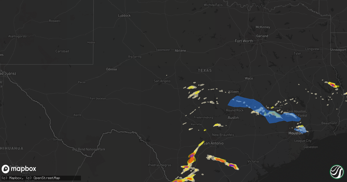
Hail Map in Texas on April 9, 2020
Get this storm
April 9 map
$229
one time, instant access
Download today. No call, no setup
Keep the $229
Bought the map and want the full workflow? Apply the entire $229 to a subscription within 7 days. None of it is wasted.
Every map, not just this one
This buys you this map. Subscription and you get every map we run, in the markets you choose from a few cities to whole states to nationwide. Plus real-time alerts the moment a storm fires.
Contact data
Name, contact info, occupancy, even credit band for addresses in the footprint. You go from where it hit to who to call.
Become the source they trust
Unlimited branding weather history reports on demand. You already have the documented answer ready for the property owner, and you are the one who showed up with it.
Property data and RoofTrace estimates
Pull up any address you have got, its value and the exact code rules for that jurisdiction, straight from One Click Code. Then RoofTrace estimates the squares, pitch, and roof value, priced the way you price.
Storm reports in Texas
Texas
| Date | Description |
|---|---|
| 04/09/20206:15 PM CDT | Corrects previous tstm wnd dmg report from onalaska. Numerous large limbs stripped of trees. Estimated wind speeds 60 mph coming off lake livingston. |
| 04/09/20206:10 PM CDT | Multiple trees fell and power lines down. |
| 04/09/20205:50 PM CDT | A local report indicates 1.00 inch wind near HEMPHILL |
| 04/09/20205:47 PM CDT | *** 1 inj *** tree down on a house... Timberlake drive. Woman with broken arm. |
| 04/09/20205:45 PM CDT | A picture was posted to facebook of hail slightly larger than golf balls that fell in pine park on fm 2024 near highway 184. |
| 04/09/20205:40 PM CDT | A local report indicates 1.00 inch wind near BRONSON |
| 04/09/20205:25 PM CDT | Trees down blocking roads in timberwilde subdivision. |
| 04/09/20205:25 PM CDT | Barn destroyed along wire rd. |
| 04/09/20205:25 PM CDT | Thunderstorm wind gusts damaged several homes on sleepy hollow circle. |
| 04/09/20205:22 PM CDT | Thunderstorm wind gusts damaged a home on crosstimbers. |
| 04/09/20205:20 PM CDT | Thunderstorm wind gusts toppled trees on to several homes on hickory dr. |
| 04/09/20205:20 PM CDT | Tree down across power lines. |
| 04/09/20205:20 PM CDT | Didlake rd closed... Trees down. |
| 04/09/20205:18 PM CDT | Thunderstorm wind gust toppled a tree on to a home on willow bend. |
| 04/09/20205:15 PM CDT | Trailer store lost part of roof; 3 bay doors blown out. |
| 04/09/20205:10 PM CDT | Trees and power lines downed along fm 1791. |
| 04/09/20205:10 PM CDT | Thunderstorm winds toppled a tree onto a house. |
| 04/09/20205:10 PM CDT | Trees down on road with diameter of about 12 inches. |
| 04/09/20205:10 PM CDT | Downed trees and power lines along fm 1696. |
| 04/09/20205:10 PM CDT | Tree down on road. |
| 04/09/20205:10 PM CDT | Tree down. |
| 04/09/20205:10 PM CDT | Multiple trees down across roadway. |
| 04/09/20205:05 PM CDT | Trees and power lines down along sh 30. |
| 04/09/20204:40 PM CDT | A local report indicates 1.00 inch wind near 1 NE UP429 |
| 04/09/20204:38 PM CDT | Hail reported on highway 6 between college station and navasota. |
| 04/09/20204:29 PM CDT | A local report indicates 1.00 inch wind near 2 ENE UP429 |
| 04/09/20204:26 PM CDT | Penny to near quarter size hail near the intersection of highway 60 and fm 3058. |
| 04/09/20204:25 PM CDT | Trees down in somerville.... |
| 04/09/20204:21 PM CDT | Corrects previous tstm wnd dmg report from 3 nne college station. Tall communications tower blown down near the intersection of texas avenue and hensel street. |
| 04/09/20204:10 PM CDT | Tall communications tower blown down near the intersection of texas avenue and hensel street. |
| 04/09/20204:05 PM CDT | Trees down. |
| 04/09/20204:00 PM CDT | Trees downed around the town of caldwell. |
| 04/09/20204:00 PM CDT | A metal barn structure was badly damaged with a couple of downed power lines in deanville. |
| 04/09/20203:36 PM CDT | Power lines down in cameron. |
| 04/09/20203:36 PM CDT | Tree down across the road on fm487 north of rockdale. |
| 04/09/20203:20 PM CDT | Trees and power lines down in and around san gabriel. Reported by milam county sheriffs office. Time estimated via radar. |
| 04/09/20203:20 PM CDT | Trees down along cr 412. Time estimated via radar. |
| 04/09/20203:20 PM CDT | Power poles and trees down near hwy 95 and prof e allen powell blvd. Debris was also found near bartlett high school down the street. |
| 04/09/20203:19 PM CDT | Damage to a shed reported north of thorndale. |
| 04/09/20203:16 PM CDT | Reports of power lines down around the city of taylor. Gusty winds. |
| 04/09/20203:00 PM CDT | Social media reported downed trees and power lines in salado; intersection of arrowhead dr and indian trail. |
| 04/09/20203:00 PM CDT | A restaurant in granger sustained roof and structural damage from strong thunderstorm winds. |
| 04/09/20202:45 PM CDT | Williamson county emergency management reports a rv overturned at a rv park in jarrell. In addition... Social media shows roof shingles are off multiple homes in and ar |
| 04/09/20202:41 PM CDT | Multiple reports of power outages from florence... Georgetown... And taylor from both news media and ems. Time estimated via radar of impacts in georgetown. |
| 04/09/20202:35 PM CDT | Winds estimated at 60 mph with some possible tree damage. Time estimate via radar. |
| 04/09/20202:15 PM CDT | The roof for a free-standing... Metal garage was torn off and thrown to the east about 75-100 yards. The walls of the garage also collapsed. |
| 04/09/202012:27 PM CDT | Quarter size hail was reported. |
| 04/09/20207:14 AM CDT | At 1213 PM CDT, a severe thunderstorm was located near Lohn, or 8 miles north of Brady, moving east at 40 mph. HAZARD...60 mph wind gusts and half dollar size hail. SOURCE...Radar indicated. IMPACT...Hail damage to vehicles is expected. Expect wind damage to roofs, siding, and trees. This severe thunderstorm will be near... Rochelle around 1220 PM CDT. Placid around 1225 PM CDT. Mercury around 1230 PM CDT. Elm Grove around 1240 PM CDT. Richland Springs and Skeeterville around 1245 PM CDT. |
| 04/09/20203:57 AM CDT | At 857 PM CDT, severe thunderstorms were located along a line extending from near Calliham to 8 miles north of Loma Alta to 9 miles west of Freer, moving east at 30 mph. HAZARD...60 mph wind gusts and half dollar size hail. SOURCE...Radar indicated. IMPACT...Hail damage to vehicles is expected. Expect wind damage to roofs, siding, and trees. Locations impacted include... Freer, Simmons, Seven Sisters, Loma Alta, Clegg and Rosita. |
| 04/09/20203:30 AM CDT | At 830 PM CDT, a severe thunderstorm was located near Tulsita, or 7 miles southeast of Kenedy, moving east at 40 mph. HAZARD...Two inch hail and 60 mph wind gusts. SOURCE...Radar indicated. IMPACT...People and animals outdoors will be injured. Expect hail damage to roofs, siding, windows, and vehicles. Expect wind damage to roofs, siding, and trees. Locations impacted include... Choate. |
| 04/09/20203:26 AM CDT | At 825 PM CDT, severe thunderstorms were located along a line extending from 9 miles northeast of Zella to 8 miles southeast of Fowlerton to 8 miles south of Fort Ewell Site, moving east at 35 mph. HAZARD...60 mph wind gusts and quarter size hail. SOURCE...Radar indicated. IMPACT...Hail damage to vehicles is expected. Expect wind damage to roofs, siding, and trees. Locations impacted include... Tilden, Fort Ewell Site, Los Angeles, Cross, Zella and Fowlerton. |
| 04/09/20203:24 AM CDT | At 824 PM CDT, a severe thunderstorm was located over Tulsita, or 11 miles south of Kenedy, moving east at 30 mph. HAZARD...Ping pong ball size hail and 60 mph wind gusts. SOURCE...Radar indicated. IMPACT...People and animals outdoors will be injured. Expect hail damage to roofs, siding, windows, and vehicles. Expect wind damage to roofs, siding, and trees. Locations impacted include... Beeville, Goliad, Mineral, Berclair, Tulsita, Normanna, Pettus, Pawnee, Tuleta and Charco. |
| 04/09/20203:00 AM CDT | At 800 PM CDT, severe thunderstorms were located along a line extending from near Gardendale to near Fort Ewell Site to 22 miles east of Encinal, moving northeast at 30 mph. HAZARD...60 mph wind gusts and quarter size hail. SOURCE...Radar indicated. IMPACT...Hail damage to vehicles is expected. Expect wind damage to roofs, siding, and trees. Locations impacted include... Cotulla, Encinal, Gardendale, Woodward, Millett, Fort Ewell Site, Los Angeles, Artesia Wells, Callaghan and Chaparral Wildlife Management Area. |
| 04/09/20202:50 AM CDT | At 750 PM CDT, severe thunderstorms were located along a line extending from 10 miles southwest of Goldfinch to 15 miles south of Fort Ewell Site, moving east at 45 mph. HAZARD...60 mph wind gusts and quarter size hail. SOURCE...Radar indicated. IMPACT...Hail damage to vehicles is expected. Expect wind damage to roofs, siding, and trees. Locations impacted include... Tilden, Seven Sisters, Loma Alta, Cross, Zella and Fowlerton. |
| 04/09/20202:34 AM CDT | At 734 PM CDT, a severe thunderstorm was located near Pleasanton, moving east at 40 mph. HAZARD...60 mph wind gusts and half dollar size hail. SOURCE...Radar indicated. IMPACT...Hail damage to vehicles is expected. Expect wind damage to roofs, siding, and trees. Locations impacted include... Kenedy, Karnes City, Runge, Falls City, Cestohowa, Coy City, Zunkerville, Choate, Fashing, Hobson, El Oso, Helena, Deweesville, McCoy and Pana Maria. |
| 04/09/20202:22 AM CDT | At 721 PM CDT, a severe thunderstorm was located near Las Vegas, or 8 miles northeast of Big Wells, moving east at 45 mph. HAZARD...60 mph wind gusts and half dollar size hail. SOURCE...Radar indicated. IMPACT...Hail damage to vehicles is expected. Expect wind damage to roofs, siding, and trees. Locations impacted include... Dilley, Divot, Derby and Las Vegas. |
| 04/09/20202:16 AM CDT | At 715 PM CDT, severe thunderstorms were located along a line extending from Chaparral Wildlife Management Area to near Encinal to 10 miles southeast of Callaghan, moving northeast at 30 mph. HAZARD...Ping pong ball size hail and 60 mph wind gusts. SOURCE...Radar indicated. IMPACT...People and animals outdoors will be injured. Expect hail damage to roofs, siding, windows, and vehicles. Expect wind damage to roofs, siding, and trees. Locations impacted include... Laredo, Cotulla, Encinal, Las Tiendas, Botines, Unitec Industrial Park, La Esperanza Ranch Airport, Ranchos Penitas West, Chupadera Ranch Airport, Columbia Bridge, Fort Ewell Site, Artesia Wells, Texas A&M International University, Gardendale, Ranchitos Las Lomas, Woodward, Doctors Hospital Of Laredo, Laredo Country Club, Millett and Orvil. |
| 04/09/20201:59 AM CDT | At 658 PM CDT, a severe thunderstorm was located 20 miles southwest of Falcon Mesa, or 22 miles southwest of Zapata, moving east at 30 mph. HAZARD...Two inch hail and 60 mph wind gusts. SOURCE...Radar indicated. IMPACT...People and animals outdoors will be injured. Expect hail damage to roofs, siding, windows, and vehicles. Expect wind damage to roofs, siding, and trees. Locations impacted include... Roma, Escobares, La Rosita, El Sauz, New Falcon, Roma Creek, Fronton, Roma High School, Salineno and Falcon State Park.This includes US Highway 83 between Mile Markers 788 and 816. |
| 04/09/20201:33 AM CDT | At 632 PM CDT, severe thunderstorms were located along a line extending from 22 miles west of Las Tiendas to near Columbia Bridge to near Laredo Community College, moving northeast at 30 mph. HAZARD...Ping pong ball size hail and 60 mph wind gusts. SOURCE...Radar indicated. IMPACT...People and animals outdoors will be injured. Expect hail damage to roofs, siding, windows, and vehicles. Expect wind damage to roofs, siding, and trees. Locations impacted include... Laredo, Encinal, Las Tiendas, Botines, Unitec Industrial Park, La Esperanza Ranch Airport, Doctors Hospital Of Laredo, Ranchos Penitas West, Orvil, Chupadera Ranch Airport, Columbia Bridge and Callaghan. |
| 04/09/20201:23 AM CDT | At 622 PM CDT, severe thunderstorms were located along a line extending from 6 miles southeast of Roman Forest to near Crosby to Kashmere Gardens, moving east at 25 mph. HAZARD...60 mph wind gusts and quarter size hail. SOURCE...Radar indicated. IMPACT...Hail damage to vehicles is expected. Expect wind damage to roofs, siding, and trees. Locations impacted include... Humble, Liberty, Dayton, Aldine, Northside / Northline, Kingwood, Barrett, Channelview, Highlands, Cloverleaf, Near Northside Houston, northeastern Greater Heights, Crosby, Roman Forest, Plum Grove, Kenefick, Dayton Lakes, Bush Intercontinental Airport, Eastex / Jensen Area and Central Northwest. |
| 04/09/20201:00 AM CDT | At 600 PM CDT, a severe thunderstorm was located near Frio Town, or 14 miles northwest of Pearsall, moving northeast at 25 mph. HAZARD...60 mph wind gusts and half dollar size hail. SOURCE...Radar indicated. IMPACT...Hail damage to vehicles is expected. Expect wind damage to roofs, siding, and trees. Locations impacted include... Yancey and Frio Town. |
| 04/09/202012:47 AM CDT | At 546 PM CDT, severe thunderstorms were located along a line extending from near Trinity to 8 miles east of New Waverly to near Tomball, moving east at 45 mph. HAZARD...60 mph wind gusts and quarter size hail. SOURCE...Radar indicated. IMPACT...Hail damage to vehicles is expected. Expect wind damage to roofs, siding, and trees. Locations impacted include... Conroe, Tomball, Cleveland, Willis, Livingston, The Woodlands, Apple Springs, Spring, Oak Ridge North, Trinity, Shepherd, Panorama Village, Shenandoah, Onalaska, Splendora, Corrigan, Patton Village, Roman Forest, Woodbranch and Cut And Shoot. |
| 04/09/202012:46 AM CDT | At 546 PM CDT, a severe thunderstorm was located near Bluff, or 14 miles west of Pearsall, moving northeast at 25 mph. HAZARD...60 mph wind gusts and half dollar size hail. SOURCE...Radar indicated. IMPACT...Hail damage to vehicles is expected. Expect wind damage to roofs, siding, and trees. Locations impacted include... Pearsall, North Pearsall and Bluff. |
| 04/09/202012:29 AM CDT | At 529 PM CDT, a severe thunderstorm was located over Jasper, moving east at 15 mph. HAZARD...60 mph wind gusts and quarter size hail. SOURCE...Radar indicated. IMPACT...Hail damage to vehicles is expected. Expect wind damage to roofs, siding, and trees. Locations impacted include... Jasper, Newton, Burkeville, Jamestown, Farrsville, Harrisburg, Mayflower and Wiergate. |
| 04/09/202012:28 AM CDT | At 527 PM CDT, a severe thunderstorm was located over Macune, or 24 miles south of Center, moving east at 15 mph. HAZARD...60 mph wind gusts and half dollar size hail. SOURCE...Radar indicated. IMPACT...Hail damage to vehicles is expected. Expect wind damage to roofs, siding, and trees. Locations impacted include... Milam, San Augustine, Hemphill, Macune, Rosevine, Bronson, Denning, Sexton and Chinaquapin. |
| 04/09/202012:00 AM CDT | At 458 PM CDT, a cluster of severe thunderstorms were located along a line extending from near Bedias to near Montgomery to 6 miles southwest of Brenham, moving east at 45 mph. These storms have had a history of producing quarter sized hail. HAZARD...70 mph wind gusts and quarter size hail. SOURCE...Radar indicated. IMPACT...Hail damage to vehicles is expected. Expect considerable tree damage. Wind damage is also likely to mobile homes, roofs, and outbuildings. Locations impacted include... Conroe, Huntsville, Brenham, Navasota, Hempstead, Willis, Prairie View, Pinehurst, The Woodlands, Washington, Waller, Panorama Village, Magnolia, Cut And Shoot, New Waverly, Pine Island, Coldspring, Point Blank, Montgomery and Stagecoach. |
| 04/08/202011:15 PM CDT | At 413 PM CDT, a severe thunderstorm was located over Somerville, or 14 miles southeast of Caldwell, moving east at 45 mph. HAZARD...70 mph wind gusts and quarter size hail. SOURCE...Radar indicated. IMPACT...Hail damage to vehicles is expected. Expect considerable tree damage. Wind damage is also likely to mobile homes, roofs, and outbuildings. Locations impacted include... College Station, Bryan, Brenham, Navasota, Caldwell, Washington, Somerville, Snook, Burton, Millican, Anderson, Lake Somerville Dam, Kyle Field, Lake Somerville State Park & Trailway, Lyons, Deanville, Independence, Quarry, Wellborn and Carlos. |
| 04/08/202010:48 PM CDT | At 348 PM CDT, a severe thunderstorm was located near Kyle, moving east at 25 mph. HAZARD...Quarter size hail. SOURCE...Radar indicated. IMPACT...Damage to vehicles is expected. Locations impacted include... San Marcos, Kyle, Buda, Uhland, Niederwald, Mountain City and Hays City. |
| 04/08/202010:43 PM CDT | At 342 PM CDT, a severe thunderstorm was located 9 miles southeast of Gilson Groves, or 22 miles west of Encinal, moving east at 35 mph. HAZARD...Two inch hail and 60 mph wind gusts. SOURCE...Radar indicated. IMPACT...People and animals outdoors will be injured. Expect hail damage to roofs, siding, windows, and vehicles. Expect wind damage to roofs, siding, and trees. Locations impacted include... La Esperanza Ranch Airport. |
| 04/08/202010:33 PM CDT | At 333 PM CDT, a severe thunderstorm was located near Tanglewood, or near Rockdale, moving southeast at 60 mph. HAZARD...70 mph wind gusts and penny size hail. SOURCE...Radar indicated. IMPACT...Expect considerable tree damage. Damage is likely to mobile homes, roofs, and outbuildings. Locations impacted include... Brenham, Caldwell, Somerville, Snook, Burton, Lake Somerville Dam, Lake Somerville State Park & Trailway, Carmine, Lyons, Deanville, Independence, Quarry and Chriesman. |
| 04/08/202010:28 PM CDT | At 328 PM CDT, severe thunderstorms were located along a line extending from near Rockdale to 7 miles west of Fedor, moving east at 40 mph. HAZARD...60 mph wind gusts. SOURCE...Radar indicated. IMPACT...Expect damage to roofs, siding, and trees. Locations impacted include... Elgin, Giddings, Lexington, Thrall, Dime Box, Fedor, Paige, Lake Somerville State Park & Trailway, Tanglewood, Knobb Springs, Blue, Beyarsville, Old Dime Box, McDade, Hare, Loebau, Leo, Noack, Lincoln and Butler. |
| 04/08/202010:27 PM CDT | At 326 PM CDT, a severe thunderstorm was located 7 miles northeast of Catarina, or 10 miles south of Big Wells, moving northeast at 30 mph. HAZARD...Golf ball size hail and 60 mph wind gusts. SOURCE...Radar indicated. IMPACT...People and animals outdoors will be injured. Expect hail damage to roofs, siding, windows, and vehicles. Expect wind damage to roofs, siding, and trees. This severe thunderstorm will remain over mainly rural areas of north central Webb County. |
| 04/08/202010:03 PM CDT | At 302 PM CDT, a severe thunderstorm was located near Granger Dam, or near Granger, moving east at 40 mph. HAZARD...70 mph wind gusts and penny size hail. SOURCE...Radar indicated. IMPACT...Expect considerable tree damage. Damage is likely to mobile homes, roofs, and outbuildings. Locations impacted include... Belton, Rockdale, Cameron, Bartlett, Salado, Little River-Academy, Rogers, Holland, Buckholts and Milano.This includes Interstate 35 between mile markers 281 and 291. |
| 04/08/20209:59 PM CDT | At 258 PM CDT, a severe thunderstorm was located near Chupadera Ranch Airport, or 29 miles south of Carrizo Springs, moving northeast at 30 mph. HAZARD...60 mph wind gusts and quarter size hail. SOURCE...Radar indicated. IMPACT...Hail damage to vehicles is expected. Expect wind damage to roofs, siding, and trees. This severe thunderstorm will remain over mainly rural areas of northwestern Webb County. |
| 04/08/20209:54 PM CDT | At 253 PM CDT, severe thunderstorms were located along a line extending from near Holland to near Granger to near Hutto, moving east at 45 mph. HAZARD...60 mph wind gusts. SOURCE...Radar indicated. IMPACT...Expect damage to roofs, siding, and trees. Locations impacted include... Taylor, Thrall, Granger Dam, Laneport, Noack, Hoxie, Waterloo, Hare and Sandoval. |
| 04/08/20209:48 PM CDT | At 248 PM CDT, a severe thunderstorm was located near Twin Sisters, or near Blanco, moving northeast at 20 mph. HAZARD...Quarter size hail. SOURCE...Radar indicated. IMPACT...Damage to vehicles is expected. Locations impacted include... Dripping Springs, Blanco, Bear Creek, Twin Sisters, Henly, Payton, Driftwood and Mount Gainor. |
| 04/08/20209:24 PM CDT | At 223 PM CDT, a severe thunderstorm was located near Killeen, moving east at 50 mph. HAZARD...60 mph wind gusts and penny size hail. SOURCE...Radar indicated. IMPACT...Expect damage to roofs, siding, and trees. Locations impacted include... Killeen, Temple, Copperas Cove, Harker Heights, Belton, Fort Hood, Nolanville, Morgan's Point Resort, Bartlett, Salado, Little River-Academy and Holland.This includes Interstate 35 between mile markers 278 and 303. |
| 04/08/20209:23 PM CDT | At 222 PM CDT, severe thunderstorms were located along a line extending from near Fort Hood to near Mahomet to near Marble Falls, moving east at 40 mph. HAZARD...60 mph wind gusts. SOURCE...Radar indicated. IMPACT...Expect damage to roofs, siding, and trees. Locations impacted include... Round Rock, Cedar Park, Georgetown, Taylor, Burnet, Marble Falls, Granger, Bertram, Serenada, Leander, Hutto, Bartlett, Meadowlakes, Liberty Hill, Jarrell, Florence, Weir, Georgetown Dam, Watson and Joppa. |
| 04/08/20208:32 PM CDT | Wind damage to garage roof partially removed and piles of hail still on the ground 15 hours after the event. |
| 04/08/20208:30 PM CDT | The karnes county emergency manager passed along pictures of wind damage to a playscape south of kenedy on highway 181. |
| 04/08/20208:30 PM CDT | A roof was blown off a large ranch lodge. |
| 04/08/20208:03 PM CDT | At 102 PM CDT, a severe thunderstorm was located near Sloan, or 9 miles south of Richland Springs, moving east at 45 mph. HAZARD...Ping pong ball size hail and 60 mph wind gusts. SOURCE...Radar indicated. IMPACT...People and animals outdoors will be injured. Expect hail damage to roofs, siding, windows, and vehicles. Expect wind damage to roofs, siding, and trees. This severe thunderstorm will be near... Sloan around 110 PM CDT. Algerita around 115 PM CDT. San Saba around 125 PM CDT.Other locations impacted by this severe thunderstorm includeHarkeyville, Spring Creek and Us-190 Near The Mcculloch-San Saba County Line. |
All States Impacted by Hail Map on April 9, 2020
Cities Impacted by Hail Map on April 9, 2020
- Cotulla, TX
- Big Wells, TX
- Crystal City, TX
- Lexington, TX
- San Saba, TX
- Ville Platte, LA
- Mamou, LA
- Oakdale, LA
- Pitkin, LA
- Glenmora, LA
- Houston, TX
- Humble, TX
- Crosby, TX
- Burnet, TX
- Leesville, LA
- Deridder, LA
- Valley Spring, TX
- Brady, TX
- Lohn, TX
- Rochelle, TX
- Huntsville, TX
- Willis, TX
- Conroe, TX
- Rio Grande City, TX
- Garciasville, TX
- Mission, TX
- Grulla, TX
- Bedias, TX
- Laredo, TX
- Zapata, TX
- Hebbronville, TX
- San Ygnacio, TX
- Castroville, TX
- Mico, TX
- San Antonio, TX
- Rio Medina, TX
- Hondo, TX
- Bush, LA
- Navasota, TX
- Falls City, TX
- Caldwell, TX
- Charlotte, TX
- Pleasanton, TX
- Jourdanton, TX
- Poteet, TX
- Goliad, TX
- Beeville, TX
- Kenedy, TX
- Dime Box, TX
- Oberlin, LA
- Elton, LA
- Port Barre, LA
- Opelousas, LA
- Miles, TX
- Picayune, MS
- Encinal, TX
- Asherton, TX
- Somerville, TX
- Washington, TX
- College Station, TX
- Brenham, TX
- Church Point, LA
- Eunice, LA
- Basile, LA
- Sunset, LA
- Arnaudville, LA
- Branch, LA
- Pearsall, TX
- Blanco, TX
- Kendalia, TX
- San Marcos, TX
- Spring Branch, TX
- Fischer, TX
- Wimberley, TX
- Canyon Lake, TX
- Montgomery, TX
- Spurger, TX
- Karnes City, TX
- Campbellton, TX
- Mason, TX
- Penitas, TX
- Catarina, TX
- D Hanis, TX
- Yancey, TX
- Dilley, TX
- Fredonia, TX
- Voca, TX
- Darrow, LA
- Donaldsonville, LA
- Geismar, LA
- Slidell, LA
- Boerne, TX
- Comfort, TX
- Richland Springs, TX
- Bartlett, TX
- Granger, TX
- Thorndale, TX
- Freer, TX
- Jasper, TX
- Brookeland, TX
- Iola, TX
- Fort Polk, LA
- Breaux Bridge, LA
- Grosse Tete, LA
- Saint Martinville, LA
- Maringouin, LA
- Plaquemine, LA
- Rockdale, TX
- Bryan, TX
- Chireno, TX
- Medina, TX
- White Castle, LA
- Iota, LA
- Llano, TX
- Buchanan Dam, TX
- Anderson, TX
- Lumberton, MS
- Pineland, TX
- Bronson, TX
- Hemphill, TX
- Pearl River, LA
- San Diego, TX
- Corrigan, TX
- Junction, TX
- San Augustine, TX
- Kempner, TX
- Hunt, TX
- Mountain Home, TX
- Castell, TX
- Oakhurst, TX
- Chester, TX
- Florence, TX
- Evans, LA
- Colmesneil, TX
- Cleveland, TX
- Wiergate, TX
- Kinder, LA
- Broaddus, TX
- Melvin, TX
- New Llano, LA
- Waller, TX
- Center Point, TX
- Jarrell, TX
- Dry Creek, LA
- Apple Springs, TX
- Merryville, LA
- Plantersville, TX
- Guerra, TX
- Killeen, TX
- Channelview, TX
- Highlands, TX
- Baytown, TX
- Call, TX
- Porter, TX
- Kingwood, TX
- Doss, TX
- Harper, TX
- Pontotoc, TX
- Lampasas, TX
- New Caney, TX
- Roma, TX
- Lometa, TX
- Carville, LA
- Kennard, TX
- Trinity, TX
- Burkeville, TX
- Hillsborough, NJ
- Hockley, TX
- Pinehurst, TX
- Cameron, TX
- Gause, TX
- Thrall, TX
- Buckholts, TX
- Hempstead, TX
- Splendora, TX
- Hutto, TX
- Davilla, TX
- Rogers, TX
- Snook, TX
- Liberty Hill, TX
- Taylor, TX
- Burton, TX
- Milano, TX
- Lyons, TX
- Salado, TX
- Chappell Hill, TX
- Spring, TX
- Magnolia, TX
- Georgetown, TX
- Belton, TX
- Holland, TX
- Tomball, TX
- Deer Park, TX
- La Porte, TX
- Conowingo, MD
- Newark, DE
- Wilmington, DE
- Port Deposit, MD
- Rising Sun, MD
- Elk Mills, MD
- Pennsville, NJ
- Penns Grove, NJ
- New Castle, DE
- Darlington, MD
- Colora, MD
- Elkton, MD
- Street, MD
- North East, MD
- Oxford, PA
- Garnet Valley, PA
- Voorhees, NJ
- Paulsboro, NJ
- Crum Lynne, PA
- Peach Bottom, PA
- Media, PA
- Medford, NJ
- Glendora, NJ
- Hockessin, DE
- Vincentown, NJ
- Philadelphia, PA
- Oaklyn, NJ
- Beachwood, NJ
- Cherry Hill, NJ
- Glenolden, PA
- Sharon Hill, PA
- Bridgeport, NJ
- Woodbury Heights, NJ
- Ridley Park, PA
- Gloucester City, NJ
- Bayville, NJ
- Kirkwood, PA
- Clementon, NJ
- Mickleton, NJ
- Toms River, NJ
- Folcroft, PA
- West Berlin, NJ
- Chester, PA
- Brookhaven, PA
- Swedesboro, NJ
- Somerdale, NJ
- Mount Laurel, NJ
- Folsom, PA
- Clarksboro, NJ
- Camden, NJ
- West Grove, PA
- Swarthmore, PA
- Seaside Heights, NJ
- Thorofare, NJ
- Lincoln University, PA
- Runnemede, NJ
- Woodlyn, PA
- Lanoka Harbor, NJ
- Manchester Township, NJ
- Sewell, NJ
- Pemberton, NJ
- Marlton, NJ
- National Park, NJ
- Gibbstown, NJ
- Prospect Park, PA
- Woodbury, NJ
- Chester Heights, PA
- Ocean Gate, NJ
- Magnolia, NJ
- Drumore, PA
- Island Heights, NJ
- Westville, NJ
- Bellmawr, NJ
- Stratford, NJ
- Mount Royal, NJ
- Yorklyn, DE
- Forked River, NJ
- Pine Beach, NJ
- Landenberg, PA
- Browns Mills, NJ
- Lawnside, NJ
- Chatsworth, NJ
- Holmes, PA
- Norwood, PA
- Barrington, NJ
- Avondale, PA
- Haddon Heights, NJ
- Seaside Park, NJ
- Quarryville, PA
- Mount Ephraim, NJ
- Montchanin, DE
- Glen Mills, PA
- Audubon, NJ
- Gibbsboro, NJ
- Cochranville, PA
- Claymont, DE
- Kennett Square, PA
- Morton, PA
- Toughkenamon, PA
- Aston, PA
- Mantua, NJ
- Essington, PA
- Blackwood, NJ
- Wenonah, NJ
- Rockland, DE
- Nottingham, PA
- Collingswood, NJ
- Marcus Hook, PA
- Haddonfield, NJ
- Wallingford, PA
- Chadds Ford, PA
- Conshohocken, PA
- Newtown Square, PA
- Brielle, NJ
- Strasburg, PA
- Bridgeport, PA
- Fairless Hills, PA
- Atglen, PA
- Malvern, PA
- Lancaster, PA
- Kinzers, PA
- Thorndale, PA
- Chesterfield, NJ
- Burlington, NJ
- Devon, PA
- Gladwyne, PA
- Exton, PA
- New Egypt, NJ
- Allentown, NJ
- Honey Brook, PA
- East Earl, PA
- Immaculata, PA
- Langhorne, PA
- Wayne, PA
- Leola, PA
- Smoketown, PA
- Wrightstown, NJ
- Narvon, PA
- Bradley Beach, NJ
- Manasquan, NJ
- Jackson, NJ
- Robbinsville, NJ
- Cheltenham, PA
- Oreland, PA
- Brick, NJ
- Plymouth Meeting, PA
- Lafayette Hill, PA
- Freehold, NJ
- Elverson, PA
- Glenside, PA
- Feasterville Trevose, PA
- Roebling, NJ
- Berwyn, PA
- King Of Prussia, PA
- Oaks, PA
- Bryn Mawr, PA
- Phoenixville, PA
- Sea Girt, NJ
- Willow Grove, PA
- Trenton, NJ
- Millstone Township, NJ
- Intercourse, PA
- Blue Bell, PA
- Bryn Athyn, PA
- Millersville, PA
- Bird In Hand, PA
- Christiana, PA
- Point Pleasant Beach, NJ
- Paradise, PA
- Levittown, PA
- Downingtown, PA
- Jenkintown, PA
- Avon By The Sea, NJ
- Glenmoore, PA
- Paoli, PA
- Flourtown, PA
- Morrisville, PA
- Farmingdale, NJ
- Chester Springs, PA
- Willow Street, PA
- New Holland, PA
- Elkins Park, PA
- Fort Washington, PA
- Bensalem, PA
- Allenwood, NJ
- Wyncote, PA
- Parkesburg, PA
- Howell, NJ
- Dresher, PA
- Ambler, PA
- Florence, NJ
- Bordentown, NJ
- West Chester, PA
- Spring Lake, NJ
- Coatesville, PA
- Cream Ridge, NJ
- Abington, PA
- Lakewood, NJ
- Gordonville, PA
- Huntingdon Valley, PA
- Gap, PA
- Ronks, PA
- Croydon, PA
- Belmar, NJ
- Bristol, PA
- Neptune, NJ
- Norristown, PA
- Villanova, PA
- Southampton, PA
- Columbus, NJ
- Cranbury, NJ
- Denver, PA
- Reinholds, PA
- Monmouth Beach, NJ
- Perkiomenville, PA
- Akron, PA
- Fort Monmouth, NJ
- Gwynedd, PA
- Warrington, PA
- Shrewsbury, NJ
- Marlboro, NJ
- Mohnton, PA
- Jamison, PA
- Leonardo, NJ
- Keansburg, NJ
- Fair Haven, NJ
- Monroe Township, NJ
- Matawan, NJ
- Stevens, PA
- Birdsboro, PA
- Port Monmouth, NJ
- Gilbertsville, PA
- Oakhurst, NJ
- Englishtown, NJ
- Morgantown, PA
- Ephrata, PA
- Titusville, NJ
- Princeton Junction, NJ
- Spotswood, NJ
- Little Silver, NJ
- Plainsboro, NJ
- Hatboro, PA
- Roosevelt, NJ
- Warminster, PA
- Long Branch, NJ
- Washington Crossing, PA
- Deal, NJ
- Pennington, NJ
- Princeton, NJ
- Furlong, PA
- Pottstown, PA
- Belford, NJ
- East Brunswick, NJ
- Royersford, PA
- Colts Neck, NJ
- Zieglerville, PA
- Lansdale, PA
- Middletown, NJ
- Allenhurst, NJ
- Keyport, NJ
- Holmdel, NJ
- Spring City, PA
- Souderton, PA
- Monmouth Junction, NJ
- Hazlet, NJ
- Hightstown, NJ
- Collegeville, PA
- Doylestown, PA
- Chalfont, PA
- Hatfield, PA
- Richboro, PA
- Newtown, PA
- Windsor, NJ
- Harleysville, PA
- Highlands, NJ
- Morganville, NJ
- Atlantic Highlands, NJ
- Lawrence Township, NJ
- Schwenksville, PA
- West Long Branch, NJ
- North Wales, PA
- Red Bank, NJ
- Rumson, NJ
- Asbury Park, NJ
- Eatontown, NJ
- Oceanport, NJ
- Boyertown, PA
- Horsham, PA
- Montgomeryville, PA
- Skippack, PA
- New Hope, PA
- Old Bridge, NJ
- Hilltown, PA
- Colmar, PA
- Terre Hill, PA
- Helmetta, NJ
- Line Lexington, PA
- Ocean Grove, NJ
- Douglassville, PA
- Dayton, NJ
- Lincroft, NJ
- Telford, PA
- East Setauket, NY
- North Babylon, NY
- Woodhaven, NY
- Coram, NY
- Old Bethpage, NY
- Water Mill, NY
- Northport, NY
- Pittstown, NJ
- Kew Gardens, NY
- Island Park, NY
- Middle Island, NY
- Colonia, NJ
- Edison, NJ
- Bethpage, NY
- Long Beach, NY
- West Kingston, RI
- Commack, NY
- Great River, NY
- Plymouth, MA
- Farmingdale, NY
- West Barnstable, MA
- Fresh Meadows, NY
- Iselin, NJ
- Ronkonkoma, NY
- Tiverton, RI
- Neshanic Station, NJ
- Dunellen, NJ
- Bellport, NY
- Portsmouth, RI
- Mineola, NY
- Shelter Island Heights, NY
- Manville, NJ
- North Brunswick, NJ
- Moriches, NY
- Rahway, NJ
- Brooklyn, NY
- Marstons Mills, MA
- Middletown, RI
- Mashpee, MA
- Saint James, NY
- Holtsville, NY
- Stony Brook, NY
- Cedarhurst, NY
- Garden City, NY
- Marion, MA
- Yaphank, NY
- Jamestown, RI
- Albertson, NY
- Jamaica, NY
- Hauppauge, NY
- Milltown, NJ
- Holbrook, NY
- Piscataway, NJ
- Stockton, NJ
- Clark, NJ
- Scotch Plains, NJ
- Belle Mead, NJ
- North Falmouth, MA
- Centerville, MA
- Oakland Gardens, NY
- Medford, NY
- Flushing, NY
- South Bound Brook, NJ
- Far Rockaway, NY
- Lynbrook, NY
- Roslyn Heights, NY
- Huntington Station, NY
- Jericho, NY
- Woodbridge, NJ
- Cutchogue, NY
- Manhasset, NY
- Middle Village, NY
- Acushnet, MA
- Brightwaters, NY
- Calverton, NY
- Kendall Park, NJ
- Port Jefferson Station, NY
- Raritan, NJ
- Stonington, CT
- Little Compton, RI
- Inwood, NY
- Wyandanch, NY
- Lawrence, NY
- Mattituck, NY
- Oakdale, NY
- East Marion, NY
- Cotuit, MA
- Avenel, NJ
- Mastic, NY
- Westerly, RI
- Bay Shore, NY
- Fairhaven, MA
- Roosevelt, NY
- Orient, NY
- North Dartmouth, MA
- Massapequa, NY
- Oceanside, NY
- Cataumet, MA
- Cold Spring Harbor, NY
- West Hempstead, NY
- Queens Village, NY
- Farmingville, NY
- Westfield, NJ
- Howard Beach, NY
- Syosset, NY
- Metuchen, NJ
- Sagamore Beach, MA
- Glen Oaks, NY
- Mount Sinai, NY
- Hempstead, NY
- Wantagh, NY
- Center Moriches, NY
- Islandia, NY
- Pipersville, PA
- Freeport, NY
- Wading River, NY
- East Islip, NY
- Skillman, NJ
- Sayreville, NJ
- Cambria Heights, NY
- Kingston, RI
- Fishers Island, NY
- Smithtown, NY
- East Sandwich, MA
- New Hyde Park, NY
- Hicksville, NY
- Baldwin, NY
- Southampton, NY
- Greenport, NY
- Keasbey, NJ
- Charlestown, RI
- Woodmere, NY
- Central Islip, NY
- Pocasset, MA
- Ozone Park, NY
- Onset, MA
- Levittown, NY
- Westport, MA
- Atlantic Beach, NY
- Fords, NJ
- Rockville Centre, NY
- Malverne, NY
- Nesconset, NY
- Rockaway Park, NY
- Saint Albans, NY
- Hampton Bays, NY
- Laurel, NY
- Woods Hole, MA
- East Wareham, MA
- Whitehouse Station, NJ
- Elizabeth, NJ
- South Amboy, NJ
- Deer Park, NY
- Lumberville, PA
- Merrick, NY
- New Bedford, MA
- Brentwood, NY
- Copiague, NY
- Parlin, NJ
- Brookhaven, NY
- East Rockaway, NY
- Elmont, NY
- Mystic, CT
- Arverne, NY
- Patchogue, NY
- Seaford, NY
- South Richmond Hill, NY
- South Ozone Park, NY
- Islip Terrace, NY
- Pawcatuck, CT
- East Northport, NY
- Port Jefferson, NY
- Southold, NY
- Highland Park, NJ
- New Brunswick, NJ
- Cuttyhunk, MA
- Greenlawn, NY
- Point Pleasant, PA
- Manorville, NY
- Lambertville, NJ
- Old Westbury, NY
- Hyannis, MA
- South Jamesport, NY
- Amityville, NY
- Shoreham, NY
- Perth Amboy, NJ
- Bradford, RI
- Newport, RI
- Fall River, MA
- Bayport, NY
- Melville, NY
- Linden, NJ
- Selden, NY
- Saunderstown, RI
- Bellmore, NY
- South River, NJ
- Centereach, NY
- Elizabethport, NJ
- Sound Beach, NY
- Frenchtown, NJ
- Rego Park, NY
- Somerville, NJ
- Cranford, NJ
- Somerset, NJ
- Richmond Hill, NY
- Carteret, NJ
- West Islip, NY
- East Meadow, NY
- Huntington, NY
- Floral Park, NY
- Rocky Point, NY
- Jamesport, NY
- Riverhead, NY
- Groton, CT
- Bayonne, NJ
- Westbury, NY
- East Quogue, NY
- Wakefield, RI
- Flagtown, NJ
- Blue Point, NY
- New Suffolk, NY
- East Hampton, NY
- Three Bridges, NJ
- Ridge, NY
- Lake Grove, NY
- West Sayville, NY
- Warren, NJ
- Buzzards Bay, MA
- Bridgewater, NJ
- Westport Point, MA
- Breezy Point, NY
- Plainview, NY
- Mattapoisett, MA
- Great Neck, NY
- Flemington, NJ
- Rosedale, NY
- Springfield Gardens, NY
- Port Reading, NJ
- Babylon, NY
- Carle Place, NY
- Peconic, NY
- Miller Place, NY
- Wareham, MA
- East Falmouth, MA
- Forest Hills, NY
- Shelter Island, NY
- Forestdale, MA
- Falmouth, MA
- Franklin Square, NY
- Narragansett, RI
- Ringoes, NJ
- South Dartmouth, MA
- Middlesex, NJ
- Glen Head, NY
- Hewlett, NY
- Sayville, NY
- Ridgewood, NY
- Osterville, MA
- South Plainfield, NJ
- Plainfield, NJ
- Franklin Park, NJ
- Sandwich, MA
- Sag Harbor, NY
- Islip, NY
- Lindenhurst, NY
- Kings Park, NY
- Williston Park, NY
- Woodbury, NY
- West Babylon, NY
- Sagamore, MA
- Staten Island, NY
- Sewaren, NJ
- Uniondale, NY
- Martinsville, NJ
- Little Neck, NY
- Roslyn, NY
- Shirley, NY
- Bellerose, NY
- Roselle, NJ
- Hopewell, NJ
- Valley Stream, NY
- Hollis, NY
- Bound Brook, NJ
- Massapequa Park, NY
- Bohemia, NY
- Rocky Hill, NJ
- Batesville, TX
- Huffman, TX


