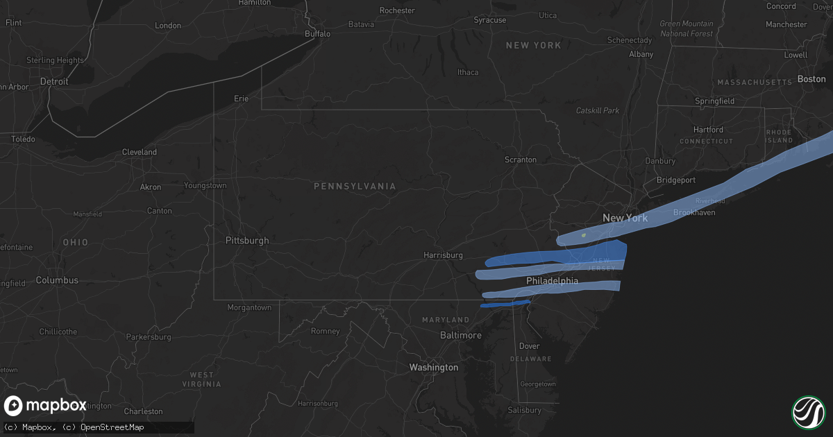
Hail Map in Pennsylvania on April 9, 2020
Get this storm
April 9 map
$229
one time, instant access
Download today. No call, no setup
Keep the $229
Bought the map and want the full workflow? Apply the entire $229 to a subscription within 7 days. None of it is wasted.
Every map, not just this one
This buys you this map. Subscription and you get every map we run, in the markets you choose from a few cities to whole states to nationwide. Plus real-time alerts the moment a storm fires.
Contact data
Name, contact info, occupancy, even credit band for addresses in the footprint. You go from where it hit to who to call.
Become the source they trust
Unlimited branding weather history reports on demand. You already have the documented answer ready for the property owner, and you are the one who showed up with it.
Property data and RoofTrace estimates
Pull up any address you have got, its value and the exact code rules for that jurisdiction, straight from One Click Code. Then RoofTrace estimates the squares, pitch, and roof value, priced the way you price.
Storm reports in Pennsylvania
Pennsylvania
| Date | Description |
|---|---|
| 04/09/20201:13 PM CDT | Tree uprooted and blocking roadway. Power lines also down. Time based on radar. |
| 04/09/20201:03 PM CDT | Itws measured gust. |
| 04/09/202012:48 PM CDT | Large tree branch fell into the street. Time estimated from radar. |
| 04/09/202012:40 PM CDT | Report from mping: 3-inch tree limbs broken; power poles broken. |
| 04/09/202012:29 PM CDT | Kphl measured 51 kt wind gust. |
| 04/09/202012:24 PM CDT | Large tree snapped in half in bells corner. Time estimated from radar. |
| 04/09/202012:20 PM CDT | Tree into a house in woodlyn. Time estimated from radar. |
| 04/09/202012:18 PM CDT | 2 large trees uprooted in richboro. Time estimated from radar. |
| 04/09/202012:15 PM CDT | Multiple large branches down in leola. |
| 04/09/202012:15 PM CDT | Outdoor shed significantly damaged. Time estimated from radar. |
| 04/09/202012:05 PM CDT | Video posted to social media shows numerous trees uprooted and downed... As well as numerous downed power lines. Time estimated. |
| 04/09/202012:00 PM CDT | Tree down on a house in lower providence township. |
| 04/09/202011:54 AM CDT | Several reports of downed trees and wires in the area. Time estimated from radar. |
| 04/09/202011:50 AM CDT | Tree down near township line road and nutt road. |
| 04/09/202011:50 AM CDT | Large tree down over rt 283 wb. |
| 04/09/202011:48 AM CDT | Trees and wires down. Pea size hail also reported. |
| 04/09/202011:42 AM CDT | Utility pole snapped in half in boyertown. Time estimated from radar. |
| 04/09/202011:37 AM CDT | Several reports of downed trees and wires in the area. Time estimated from radar. |
| 04/09/202011:24 AM CDT | Photos of several large trees down in the area. Time estimated from radar. |
| 04/09/202011:21 AM CDT | Several reports of downed trees and wires in the area. Time estimated from radar. |
| 04/09/202011:15 AM CDT | A local report indicates 58 MPH wind near LANCASTER AIRPORT |
| 04/09/202011:10 AM CDT | Several reports of downed trees and wires in the area. Time estimated from radar. |
| 04/09/202011:10 AM CDT | Multiple trees down in lititz. Time estimated from radar. |
| 04/09/20207:56 AM CDT | At 1256 PM EDT, a severe thunderstorm was located over East Petersburg, moving east at 60 mph. HAZARD...65 mph wind gusts. SOURCE...Radar indicated. IMPACT...Expect damage to trees, roofs, and siding. Locations impacted include... Lancaster, Ephrata, Lititz, Millersville, Willow Street, New Holland, Manheim, East Petersburg, Akron, Leola, Paradise, Salunga-Landisville, Denver, Reamstown, Rothsville, Strasburg, Mountville, Adamstown, Brickerville and Terre Hill.This includes The Pennsylvania Turnpike from mile markers 267 to 295. |
| 04/09/20207:23 AM CDT | At 1222 PM EDT, severe thunderstorms were located along a line extending from Laureldale to near Adamstown to near Strasburg, moving east at 55 mph. HAZARD...60 mph wind gusts and penny size hail. SOURCE...Radar indicated. IMPACT...Damage to roofs, siding, trees, and power lines is possible. Locations impacted include... Reading, West Chester, Norristown, Pottstown, Phoenixville, Lansdale, West Norriton, East Norriton, Coatesville, Wyomissing, Quakertown, Perkasie, Downingtown, Souderton, Bedminster, Birdsboro, Collegeville, Royersford, Fleetwood and Chalfont.This includes the following highways... Pennsylvania Turnpike between exits 298 and 326. Northeast Extension between exits A31 and A44. Interstate 176 in Pennsylvania between mile markers 1 and 11. Interstate 76 in Pennsylvania near mile marker 327. |
| 04/09/20207:01 AM CDT | At 1200 PM EDT, a severe thunderstorm was located over Manheim, moving east at 60 mph. HAZARD...60 mph wind gusts. SOURCE...Radar indicated. IMPACT...Expect damage to trees, roofs, and siding. This severe thunderstorm will be near... Akron, Ephrata and Leola around 1210 PM EDT. New Holland, Adamstown, Terre Hill, Reamstown, Denver and Churchtown around 1220 PM EDT.Other locations impacted by this severe thunderstorm includeGoodville, Schoeneck, Bowmansville, Penryn, Mount Gretna,Fivepointville, Blue Ball, Farmersville, Reinholds and LancasterAirport.This includes The Pennsylvania Turnpike from mile markers 262 to 295. |
| 04/09/20206:51 AM CDT | At 1151 AM EDT, severe thunderstorms were located along a line extending from near Emmitsburg to near Brunswick, moving east at 50 mph. HAZARD...60 mph wind gusts. SOURCE...Radar indicated. IMPACT...Damaging winds will cause some trees and large branches to fall. This could injure those outdoors, as well as damage homes and vehicles. Roadways may become blocked by downed trees. Localized power outages are possible. Unsecured light objects may become projectiles. Locations impacted include... Frederick, Westminster, Damascus, Thurmont, Emmitsburg, Harry Grove Stadium, Ellicott City, Randallstown, Owings Mills, Eldersburg, Reisterstown, Ballenger Creek, Mount Airy, Taneytown, Hampstead, Walkersville, Manchester, Sykesville, Braddock Heights and Oakland. |
| 04/08/202010:52 PM CDT | Downed tree on laurel heights road. Time estimated from radar. |
| 04/08/202010:52 PM CDT | Downed wires near the intersection of chesterville road and penn green road. Time estimated from radar. |
| 04/08/202010:50 PM CDT | Several reports of downed trees and power lines in the west grove and landenberg areas. Time estimated from radar. |
| 04/08/202010:45 PM CDT | Deos sensor. |
| 04/08/202010:40 PM CDT | Downed tree on state highway 472. Time estimated from radar. |
| 04/08/202010:35 PM CDT | Downed wires near the intersection of mount pleasant road and grant street. Time estimated from radar. |
| 04/08/202010:28 PM CDT | Several trees down near pleasant grove |
| 04/08/20209:56 PM CDT | Broken window on the kissing tower at hersheypark according to pennlive. Time estimated from mdt asos gust report. |
| 04/08/20208:33 PM CDT | At 132 PM EDT, severe thunderstorms were located along a line extending from Tullytown to Swedesboro, moving east at 40 mph. HAZARD...60 mph wind gusts and penny size hail. SOURCE...Radar indicated. IMPACT...Damage to roofs, siding, trees, and power lines is possible. Locations impacted include... Philadelphia, Toms River, Trenton, Camden, Gloucester City, Lakewood, Cherry Hill, Bensalem, Jackson, Howell, Evesham, Mount Laurel, Willingboro, Deptford, Voorhees, Medford, West Deptford, Glassboro, Lindenwold and Hammonton.People attending Covid-19 Drive through testing should seek safeshelter immediately!This includes the following highways... Atlantic City Expressway between mile markers 21 and 44. Garden State Parkway between mile markers 83 and 99. Interstate 195 in New Jersey between mile markers 0 and 34. Interstate 295 in New Jersey between mile markers 8 and 61. Interstate 95 in Pennsylvania between mile markers 14 and 40. New Jersey Turnpike between exits 2 and 8. Interstate 676 in New Jersey between mile markers 0 and 4. Interstate 76 in New Jersey between mile markers 0 and 3. Interstate 76 in Pennsylvania between mile markers 348 and 351. |
All States Impacted by Hail Map on April 9, 2020
Cities Impacted by Hail Map on April 9, 2020
- Cotulla, TX
- Big Wells, TX
- Crystal City, TX
- Lexington, TX
- San Saba, TX
- Ville Platte, LA
- Mamou, LA
- Oakdale, LA
- Pitkin, LA
- Glenmora, LA
- Houston, TX
- Humble, TX
- Crosby, TX
- Burnet, TX
- Leesville, LA
- Deridder, LA
- Valley Spring, TX
- Brady, TX
- Lohn, TX
- Rochelle, TX
- Huntsville, TX
- Willis, TX
- Conroe, TX
- Rio Grande City, TX
- Garciasville, TX
- Mission, TX
- Grulla, TX
- Bedias, TX
- Laredo, TX
- Zapata, TX
- Hebbronville, TX
- San Ygnacio, TX
- Castroville, TX
- Mico, TX
- San Antonio, TX
- Rio Medina, TX
- Hondo, TX
- Bush, LA
- Navasota, TX
- Falls City, TX
- Caldwell, TX
- Charlotte, TX
- Pleasanton, TX
- Jourdanton, TX
- Poteet, TX
- Goliad, TX
- Beeville, TX
- Kenedy, TX
- Dime Box, TX
- Oberlin, LA
- Elton, LA
- Port Barre, LA
- Opelousas, LA
- Miles, TX
- Picayune, MS
- Encinal, TX
- Asherton, TX
- Somerville, TX
- Washington, TX
- College Station, TX
- Brenham, TX
- Church Point, LA
- Eunice, LA
- Basile, LA
- Sunset, LA
- Arnaudville, LA
- Branch, LA
- Pearsall, TX
- Blanco, TX
- Kendalia, TX
- San Marcos, TX
- Spring Branch, TX
- Fischer, TX
- Wimberley, TX
- Canyon Lake, TX
- Montgomery, TX
- Spurger, TX
- Karnes City, TX
- Campbellton, TX
- Mason, TX
- Penitas, TX
- Catarina, TX
- D Hanis, TX
- Yancey, TX
- Dilley, TX
- Fredonia, TX
- Voca, TX
- Darrow, LA
- Donaldsonville, LA
- Geismar, LA
- Slidell, LA
- Boerne, TX
- Comfort, TX
- Richland Springs, TX
- Bartlett, TX
- Granger, TX
- Thorndale, TX
- Freer, TX
- Jasper, TX
- Brookeland, TX
- Iola, TX
- Fort Polk, LA
- Breaux Bridge, LA
- Grosse Tete, LA
- Saint Martinville, LA
- Maringouin, LA
- Plaquemine, LA
- Rockdale, TX
- Bryan, TX
- Chireno, TX
- Medina, TX
- White Castle, LA
- Iota, LA
- Llano, TX
- Buchanan Dam, TX
- Anderson, TX
- Lumberton, MS
- Pineland, TX
- Bronson, TX
- Hemphill, TX
- Pearl River, LA
- San Diego, TX
- Corrigan, TX
- Junction, TX
- San Augustine, TX
- Kempner, TX
- Hunt, TX
- Mountain Home, TX
- Castell, TX
- Oakhurst, TX
- Chester, TX
- Florence, TX
- Evans, LA
- Colmesneil, TX
- Cleveland, TX
- Wiergate, TX
- Kinder, LA
- Broaddus, TX
- Melvin, TX
- New Llano, LA
- Waller, TX
- Center Point, TX
- Jarrell, TX
- Dry Creek, LA
- Apple Springs, TX
- Merryville, LA
- Plantersville, TX
- Guerra, TX
- Killeen, TX
- Channelview, TX
- Highlands, TX
- Baytown, TX
- Call, TX
- Porter, TX
- Kingwood, TX
- Doss, TX
- Harper, TX
- Pontotoc, TX
- Lampasas, TX
- New Caney, TX
- Roma, TX
- Lometa, TX
- Carville, LA
- Kennard, TX
- Trinity, TX
- Burkeville, TX
- Hillsborough, NJ
- Hockley, TX
- Pinehurst, TX
- Cameron, TX
- Gause, TX
- Thrall, TX
- Buckholts, TX
- Hempstead, TX
- Splendora, TX
- Hutto, TX
- Davilla, TX
- Rogers, TX
- Snook, TX
- Liberty Hill, TX
- Taylor, TX
- Burton, TX
- Milano, TX
- Lyons, TX
- Salado, TX
- Chappell Hill, TX
- Spring, TX
- Magnolia, TX
- Georgetown, TX
- Belton, TX
- Holland, TX
- Tomball, TX
- Deer Park, TX
- La Porte, TX
- Conowingo, MD
- Newark, DE
- Wilmington, DE
- Port Deposit, MD
- Rising Sun, MD
- Elk Mills, MD
- Pennsville, NJ
- Penns Grove, NJ
- New Castle, DE
- Darlington, MD
- Colora, MD
- Elkton, MD
- Street, MD
- North East, MD
- Oxford, PA
- Garnet Valley, PA
- Voorhees, NJ
- Paulsboro, NJ
- Crum Lynne, PA
- Peach Bottom, PA
- Media, PA
- Medford, NJ
- Glendora, NJ
- Hockessin, DE
- Vincentown, NJ
- Philadelphia, PA
- Oaklyn, NJ
- Beachwood, NJ
- Cherry Hill, NJ
- Glenolden, PA
- Sharon Hill, PA
- Bridgeport, NJ
- Woodbury Heights, NJ
- Ridley Park, PA
- Gloucester City, NJ
- Bayville, NJ
- Kirkwood, PA
- Clementon, NJ
- Mickleton, NJ
- Toms River, NJ
- Folcroft, PA
- West Berlin, NJ
- Chester, PA
- Brookhaven, PA
- Swedesboro, NJ
- Somerdale, NJ
- Mount Laurel, NJ
- Folsom, PA
- Clarksboro, NJ
- Camden, NJ
- West Grove, PA
- Swarthmore, PA
- Seaside Heights, NJ
- Thorofare, NJ
- Lincoln University, PA
- Runnemede, NJ
- Woodlyn, PA
- Lanoka Harbor, NJ
- Manchester Township, NJ
- Sewell, NJ
- Pemberton, NJ
- Marlton, NJ
- National Park, NJ
- Gibbstown, NJ
- Prospect Park, PA
- Woodbury, NJ
- Chester Heights, PA
- Ocean Gate, NJ
- Magnolia, NJ
- Drumore, PA
- Island Heights, NJ
- Westville, NJ
- Bellmawr, NJ
- Stratford, NJ
- Mount Royal, NJ
- Yorklyn, DE
- Forked River, NJ
- Pine Beach, NJ
- Landenberg, PA
- Browns Mills, NJ
- Lawnside, NJ
- Chatsworth, NJ
- Holmes, PA
- Norwood, PA
- Barrington, NJ
- Avondale, PA
- Haddon Heights, NJ
- Seaside Park, NJ
- Quarryville, PA
- Mount Ephraim, NJ
- Montchanin, DE
- Glen Mills, PA
- Audubon, NJ
- Gibbsboro, NJ
- Cochranville, PA
- Claymont, DE
- Kennett Square, PA
- Morton, PA
- Toughkenamon, PA
- Aston, PA
- Mantua, NJ
- Essington, PA
- Blackwood, NJ
- Wenonah, NJ
- Rockland, DE
- Nottingham, PA
- Collingswood, NJ
- Marcus Hook, PA
- Haddonfield, NJ
- Wallingford, PA
- Chadds Ford, PA
- Conshohocken, PA
- Newtown Square, PA
- Brielle, NJ
- Strasburg, PA
- Bridgeport, PA
- Fairless Hills, PA
- Atglen, PA
- Malvern, PA
- Lancaster, PA
- Kinzers, PA
- Thorndale, PA
- Chesterfield, NJ
- Burlington, NJ
- Devon, PA
- Gladwyne, PA
- Exton, PA
- New Egypt, NJ
- Allentown, NJ
- Honey Brook, PA
- East Earl, PA
- Immaculata, PA
- Langhorne, PA
- Wayne, PA
- Leola, PA
- Smoketown, PA
- Wrightstown, NJ
- Narvon, PA
- Bradley Beach, NJ
- Manasquan, NJ
- Jackson, NJ
- Robbinsville, NJ
- Cheltenham, PA
- Oreland, PA
- Brick, NJ
- Plymouth Meeting, PA
- Lafayette Hill, PA
- Freehold, NJ
- Elverson, PA
- Glenside, PA
- Feasterville Trevose, PA
- Roebling, NJ
- Berwyn, PA
- King Of Prussia, PA
- Oaks, PA
- Bryn Mawr, PA
- Phoenixville, PA
- Sea Girt, NJ
- Willow Grove, PA
- Trenton, NJ
- Millstone Township, NJ
- Intercourse, PA
- Blue Bell, PA
- Bryn Athyn, PA
- Millersville, PA
- Bird In Hand, PA
- Christiana, PA
- Point Pleasant Beach, NJ
- Paradise, PA
- Levittown, PA
- Downingtown, PA
- Jenkintown, PA
- Avon By The Sea, NJ
- Glenmoore, PA
- Paoli, PA
- Flourtown, PA
- Morrisville, PA
- Farmingdale, NJ
- Chester Springs, PA
- Willow Street, PA
- New Holland, PA
- Elkins Park, PA
- Fort Washington, PA
- Bensalem, PA
- Allenwood, NJ
- Wyncote, PA
- Parkesburg, PA
- Howell, NJ
- Dresher, PA
- Ambler, PA
- Florence, NJ
- Bordentown, NJ
- West Chester, PA
- Spring Lake, NJ
- Coatesville, PA
- Cream Ridge, NJ
- Abington, PA
- Lakewood, NJ
- Gordonville, PA
- Huntingdon Valley, PA
- Gap, PA
- Ronks, PA
- Croydon, PA
- Belmar, NJ
- Bristol, PA
- Neptune, NJ
- Norristown, PA
- Villanova, PA
- Southampton, PA
- Columbus, NJ
- Cranbury, NJ
- Denver, PA
- Reinholds, PA
- Monmouth Beach, NJ
- Perkiomenville, PA
- Akron, PA
- Fort Monmouth, NJ
- Gwynedd, PA
- Warrington, PA
- Shrewsbury, NJ
- Marlboro, NJ
- Mohnton, PA
- Jamison, PA
- Leonardo, NJ
- Keansburg, NJ
- Fair Haven, NJ
- Monroe Township, NJ
- Matawan, NJ
- Stevens, PA
- Birdsboro, PA
- Port Monmouth, NJ
- Gilbertsville, PA
- Oakhurst, NJ
- Englishtown, NJ
- Morgantown, PA
- Ephrata, PA
- Titusville, NJ
- Princeton Junction, NJ
- Spotswood, NJ
- Little Silver, NJ
- Plainsboro, NJ
- Hatboro, PA
- Roosevelt, NJ
- Warminster, PA
- Long Branch, NJ
- Washington Crossing, PA
- Deal, NJ
- Pennington, NJ
- Princeton, NJ
- Furlong, PA
- Pottstown, PA
- Belford, NJ
- East Brunswick, NJ
- Royersford, PA
- Colts Neck, NJ
- Zieglerville, PA
- Lansdale, PA
- Middletown, NJ
- Allenhurst, NJ
- Keyport, NJ
- Holmdel, NJ
- Spring City, PA
- Souderton, PA
- Monmouth Junction, NJ
- Hazlet, NJ
- Hightstown, NJ
- Collegeville, PA
- Doylestown, PA
- Chalfont, PA
- Hatfield, PA
- Richboro, PA
- Newtown, PA
- Windsor, NJ
- Harleysville, PA
- Highlands, NJ
- Morganville, NJ
- Atlantic Highlands, NJ
- Lawrence Township, NJ
- Schwenksville, PA
- West Long Branch, NJ
- North Wales, PA
- Red Bank, NJ
- Rumson, NJ
- Asbury Park, NJ
- Eatontown, NJ
- Oceanport, NJ
- Boyertown, PA
- Horsham, PA
- Montgomeryville, PA
- Skippack, PA
- New Hope, PA
- Old Bridge, NJ
- Hilltown, PA
- Colmar, PA
- Terre Hill, PA
- Helmetta, NJ
- Line Lexington, PA
- Ocean Grove, NJ
- Douglassville, PA
- Dayton, NJ
- Lincroft, NJ
- Telford, PA
- East Setauket, NY
- North Babylon, NY
- Woodhaven, NY
- Coram, NY
- Old Bethpage, NY
- Water Mill, NY
- Northport, NY
- Pittstown, NJ
- Kew Gardens, NY
- Island Park, NY
- Middle Island, NY
- Colonia, NJ
- Edison, NJ
- Bethpage, NY
- Long Beach, NY
- West Kingston, RI
- Commack, NY
- Great River, NY
- Plymouth, MA
- Farmingdale, NY
- West Barnstable, MA
- Fresh Meadows, NY
- Iselin, NJ
- Ronkonkoma, NY
- Tiverton, RI
- Neshanic Station, NJ
- Dunellen, NJ
- Bellport, NY
- Portsmouth, RI
- Mineola, NY
- Shelter Island Heights, NY
- Manville, NJ
- North Brunswick, NJ
- Moriches, NY
- Rahway, NJ
- Brooklyn, NY
- Marstons Mills, MA
- Middletown, RI
- Mashpee, MA
- Saint James, NY
- Holtsville, NY
- Stony Brook, NY
- Cedarhurst, NY
- Garden City, NY
- Marion, MA
- Yaphank, NY
- Jamestown, RI
- Albertson, NY
- Jamaica, NY
- Hauppauge, NY
- Milltown, NJ
- Holbrook, NY
- Piscataway, NJ
- Stockton, NJ
- Clark, NJ
- Scotch Plains, NJ
- Belle Mead, NJ
- North Falmouth, MA
- Centerville, MA
- Oakland Gardens, NY
- Medford, NY
- Flushing, NY
- South Bound Brook, NJ
- Far Rockaway, NY
- Lynbrook, NY
- Roslyn Heights, NY
- Huntington Station, NY
- Jericho, NY
- Woodbridge, NJ
- Cutchogue, NY
- Manhasset, NY
- Middle Village, NY
- Acushnet, MA
- Brightwaters, NY
- Calverton, NY
- Kendall Park, NJ
- Port Jefferson Station, NY
- Raritan, NJ
- Stonington, CT
- Little Compton, RI
- Inwood, NY
- Wyandanch, NY
- Lawrence, NY
- Mattituck, NY
- Oakdale, NY
- East Marion, NY
- Cotuit, MA
- Avenel, NJ
- Mastic, NY
- Westerly, RI
- Bay Shore, NY
- Fairhaven, MA
- Roosevelt, NY
- Orient, NY
- North Dartmouth, MA
- Massapequa, NY
- Oceanside, NY
- Cataumet, MA
- Cold Spring Harbor, NY
- West Hempstead, NY
- Queens Village, NY
- Farmingville, NY
- Westfield, NJ
- Howard Beach, NY
- Syosset, NY
- Metuchen, NJ
- Sagamore Beach, MA
- Glen Oaks, NY
- Mount Sinai, NY
- Hempstead, NY
- Wantagh, NY
- Center Moriches, NY
- Islandia, NY
- Pipersville, PA
- Freeport, NY
- Wading River, NY
- East Islip, NY
- Skillman, NJ
- Sayreville, NJ
- Cambria Heights, NY
- Kingston, RI
- Fishers Island, NY
- Smithtown, NY
- East Sandwich, MA
- New Hyde Park, NY
- Hicksville, NY
- Baldwin, NY
- Southampton, NY
- Greenport, NY
- Keasbey, NJ
- Charlestown, RI
- Woodmere, NY
- Central Islip, NY
- Pocasset, MA
- Ozone Park, NY
- Onset, MA
- Levittown, NY
- Westport, MA
- Atlantic Beach, NY
- Fords, NJ
- Rockville Centre, NY
- Malverne, NY
- Nesconset, NY
- Rockaway Park, NY
- Saint Albans, NY
- Hampton Bays, NY
- Laurel, NY
- Woods Hole, MA
- East Wareham, MA
- Whitehouse Station, NJ
- Elizabeth, NJ
- South Amboy, NJ
- Deer Park, NY
- Lumberville, PA
- Merrick, NY
- New Bedford, MA
- Brentwood, NY
- Copiague, NY
- Parlin, NJ
- Brookhaven, NY
- East Rockaway, NY
- Elmont, NY
- Mystic, CT
- Arverne, NY
- Patchogue, NY
- Seaford, NY
- South Richmond Hill, NY
- South Ozone Park, NY
- Islip Terrace, NY
- Pawcatuck, CT
- East Northport, NY
- Port Jefferson, NY
- Southold, NY
- Highland Park, NJ
- New Brunswick, NJ
- Cuttyhunk, MA
- Greenlawn, NY
- Point Pleasant, PA
- Manorville, NY
- Lambertville, NJ
- Old Westbury, NY
- Hyannis, MA
- South Jamesport, NY
- Amityville, NY
- Shoreham, NY
- Perth Amboy, NJ
- Bradford, RI
- Newport, RI
- Fall River, MA
- Bayport, NY
- Melville, NY
- Linden, NJ
- Selden, NY
- Saunderstown, RI
- Bellmore, NY
- South River, NJ
- Centereach, NY
- Elizabethport, NJ
- Sound Beach, NY
- Frenchtown, NJ
- Rego Park, NY
- Somerville, NJ
- Cranford, NJ
- Somerset, NJ
- Richmond Hill, NY
- Carteret, NJ
- West Islip, NY
- East Meadow, NY
- Huntington, NY
- Floral Park, NY
- Rocky Point, NY
- Jamesport, NY
- Riverhead, NY
- Groton, CT
- Bayonne, NJ
- Westbury, NY
- East Quogue, NY
- Wakefield, RI
- Flagtown, NJ
- Blue Point, NY
- New Suffolk, NY
- East Hampton, NY
- Three Bridges, NJ
- Ridge, NY
- Lake Grove, NY
- West Sayville, NY
- Warren, NJ
- Buzzards Bay, MA
- Bridgewater, NJ
- Westport Point, MA
- Breezy Point, NY
- Plainview, NY
- Mattapoisett, MA
- Great Neck, NY
- Flemington, NJ
- Rosedale, NY
- Springfield Gardens, NY
- Port Reading, NJ
- Babylon, NY
- Carle Place, NY
- Peconic, NY
- Miller Place, NY
- Wareham, MA
- East Falmouth, MA
- Forest Hills, NY
- Shelter Island, NY
- Forestdale, MA
- Falmouth, MA
- Franklin Square, NY
- Narragansett, RI
- Ringoes, NJ
- South Dartmouth, MA
- Middlesex, NJ
- Glen Head, NY
- Hewlett, NY
- Sayville, NY
- Ridgewood, NY
- Osterville, MA
- South Plainfield, NJ
- Plainfield, NJ
- Franklin Park, NJ
- Sandwich, MA
- Sag Harbor, NY
- Islip, NY
- Lindenhurst, NY
- Kings Park, NY
- Williston Park, NY
- Woodbury, NY
- West Babylon, NY
- Sagamore, MA
- Staten Island, NY
- Sewaren, NJ
- Uniondale, NY
- Martinsville, NJ
- Little Neck, NY
- Roslyn, NY
- Shirley, NY
- Bellerose, NY
- Roselle, NJ
- Hopewell, NJ
- Valley Stream, NY
- Hollis, NY
- Bound Brook, NJ
- Massapequa Park, NY
- Bohemia, NY
- Rocky Hill, NJ
- Batesville, TX
- Huffman, TX


