Hail Map in New Jersey on April 9, 2020
Get this storm
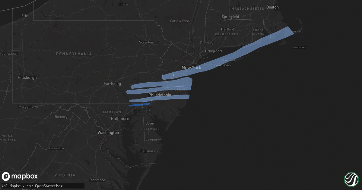
April 9 map
$229
one time, instant access
Download today. No call, no setup
Keep the $229
Bought the map and want the full workflow? Apply the entire $229 to a subscription within 7 days. None of it is wasted.
Every map, not just this one
This buys you this map. Subscription and you get every map we run, in the markets you choose from a few cities to whole states to nationwide. Plus real-time alerts the moment a storm fires.
Contact data
Name, contact info, occupancy, even credit band for addresses in the footprint. You go from where it hit to who to call.
Become the source they trust
Unlimited branding weather history reports on demand. You already have the documented answer ready for the property owner, and you are the one who showed up with it.
Property data and RoofTrace estimates
Pull up any address you have got, its value and the exact code rules for that jurisdiction, straight from One Click Code. Then RoofTrace estimates the squares, pitch, and roof value, priced the way you price.
Storm reports in New Jersey
New Jersey
| Date | Description |
|---|---|
| 04/09/20201:39 PM CDT | Njwxnet measured gust. |
| 04/09/20201:30 PM CDT | Report from mping: trees uprooted or snapped. Time correct based on radar. |
| 04/09/20201:29 PM CDT | A local report indicates 62 MPH wind near 4 ESE LANOKA HARBOR |
| 04/09/20201:25 PM CDT | Njwxnet measured gust. |
| 04/09/20201:15 PM CDT | Photo shows a large tree fallen onto a residence. No injuries reported. Time estimated from radar. |
| 04/09/20201:12 PM CDT | Large tree down into a home on heck ave in neptune. Heck ave is closed between fisher and myrtle. Time estimated from radar. |
| 04/09/20201:10 PM CDT | A local report indicates 64 MPH wind near OCEAN COUNTY AIRPORT (K |
| 04/09/202012:55 PM CDT | A local report indicates 66 MPH wind near LINDEN AIRPORT |
| 04/09/202012:52 PM CDT | A local report indicates 63 MPH wind near PORT READING |
| 04/09/202012:50 PM CDT | A local report indicates 60 MPH wind near SEWELL |
| 04/09/202012:46 PM CDT | Several large tree limbs downed with some minor property damage at a residence. Time estimated from radar. |
| 04/09/202012:45 PM CDT | Large branch down in mount laurel on marne highway near creek road. |
| 04/09/202012:45 PM CDT | Large tree uprooted. Time estimated from radar. |
| 04/09/202012:45 PM CDT | Power line down in mount laurel on coral avenue. |
| 04/09/202012:42 PM CDT | Downed tree on interstate 295 north of exit 43. Lane restrictions were required. Time estimated from radar. |
| 04/09/202012:42 PM CDT | Trees and wires reported down in edison and metuchen. Time estimated from radar. |
| 04/09/202012:42 PM CDT | Mostly pea size with a few stones to quarter size. Time estimated from radar. |
| 04/09/202012:40 PM CDT | Road closed due to trees down across the road. Time estimated from radar. |
| 04/09/202012:39 PM CDT | Downed tree on interstate 295 south of exit 34. Lane restrictions were required. Time estimated from radar. |
| 04/09/202012:37 PM CDT | Photo of a hardwood tree down. |
| 04/09/202012:37 PM CDT | Fencing blown over and several large tree limbs down at a residence. Time estimated from radar. |
| 04/09/202012:36 PM CDT | Parlin lane closed due to down trees and wires. Time estimated from radar. |
| 04/09/202012:36 PM CDT | Photos of trees and power poles downed on social media. Time estimated from radar. |
| 04/09/202012:35 PM CDT | Winds of 50-60 mph reported in gloucester city. |
| 04/09/202012:35 PM CDT | Njwxnet measured gust. |
| 04/09/202012:35 PM CDT | Corrects previous tstm wnd dmg report from 1 ssw florence. Downed tree blocking the right lane of west bound nj turnpike. Time estimated from radar. |
| 04/09/202012:35 PM CDT | A section of a roof was peeled off with reports of large branches scattered about in the city. |
| 04/09/202012:35 PM CDT | Njwxnet measured gust. |
| 04/09/202012:30 PM CDT | Large spruce tree down across driveway. Time estimated from radar. |
| 04/09/202012:30 PM CDT | Downed tree blocking the right lane of west bound nj turnpike. Time estimated from radar. |
| 04/09/202012:18 PM CDT | Large tree uprooted. Time estimated from radar. |
| 04/09/202012:06 PM CDT | Tree down on tumble falls road in kingwood township. Time estimated from radar. |
| 04/09/202012:16 AM CDT | A local report indicates 58 MPH wind near 2 SW BEACH HAVEN |
| 04/09/202012:12 AM CDT | Wxflow sensor. |
| 04/09/202012:02 AM CDT | A local report indicates 62 MPH wind near ATLANTIC CITY INTERNATI |
| 04/08/202011:44 PM CDT | Downed trees and power lines near yock wock road. Time estimated from radar. |
| 04/08/202011:39 PM CDT | Downed trees and power lines. Time estimated from radar. |
| 04/08/202011:30 PM CDT | Mping report of tree limbs down and shingles blown off. Time estimated from radar. |
| 04/08/202011:30 PM CDT | Mping report of tree limbs down and shingles blown off. Time estimated from radar. |
| 04/08/202011:25 PM CDT | Several reports of power lines down. Time estimated from radar. |
| 04/08/202011:25 PM CDT | Njwxnet sensor. |
| 04/08/202011:20 PM CDT | Several reports of downed power lines in the area. Time estimated from social media and radar. |
| 04/08/202011:15 PM CDT | Njwxnet sensor. |
| 04/08/202011:10 PM CDT | Several reports of power poles and wires down in and near salem. Time estimated from radar. |
| 04/08/202011:06 PM CDT | Several reports of downed power lines from penns grove to pennsville. |
| 04/08/202011:03 PM CDT | Downed tree at a residence. Report via social media. Time estimated from radar. |
| 04/08/20209:08 PM CDT | At 208 PM EDT, severe thunderstorms were located along a line extending from near Jacksons Mills to near Old Halfway to near Hammonton, moving east at 65 mph. HAZARD...60 mph wind gusts and penny size hail. SOURCE...Radar indicated. IMPACT...Damage to roofs, siding, trees, and power lines is possible. Locations impacted include... Toms River, Asbury Park, Lakewood, Jackson, Howell, Barnegat, Tinton Falls, Hammonton, Beachwood, Manasquan, Point Pleasant Beach, Egg Harbor City, Tuckerton, Seaside Heights, Lakehurst, Farmingdale, Surf City, Port Republic, Mantoloking and Allenwood.People attending Covid-19 Drive through testing should seek safeshelter immediately!This includes the following highways... Atlantic City Expressway between mile markers 23 and 27. Garden State Parkway between mile markers 48 and 102. Interstate 195 in New Jersey between mile markers 17 and 34. |
| 04/08/20208:34 PM CDT | At 133 PM EDT, severe thunderstorms were located along a line extending from Summit to Kingston, moving east at 65 mph. HAZARD...60 mph wind gusts and quarter size hail. SOURCE...Radar indicated. IMPACT...Minor hail damage to vehicles is possible. Expect wind damage to trees and power lines. Severe thunderstorms will be near... Elizabeth and Linden around 140 PM EDT. Newark and Bayonne around 145 PM EDT. Jersey City and Hoboken around 150 PM EDT. Midtown Manhattan and Long Island City around 155 PM EDT. Huguenot and Forest Hills around 200 PM EDT. Clearview Expressway around 205 PM EDT. Rockaway Beach and Coney Island around 210 PM EDT. |
| 04/08/20208:26 PM CDT | At 125 PM EDT, a severe thunderstorm was located over Glenmoore, or 12 miles northwest of West Chester, moving east at 55 mph. HAZARD...60 mph wind gusts. SOURCE...Radar indicated. IMPACT...Damage to roofs, siding, trees, and power lines is possible. Locations impacted include... Philadelphia, West Chester, Norristown, Chester, Pottstown, Phoenixville, Lansdale, West Norriton, East Norriton, Coatesville, Yeadon, Westtown, Downingtown, Conshohocken, Hatboro, Folcroft, Ambler, Swarthmore, Birdsboro and Collegeville.People attending Covid-19 Drive through testing should seek safeshelter immediately!This includes the following highways... Interstate 95 in Pennsylvania between mile markers 7 and 16, andnear mile marker 22. Interstate 476 in Pennsylvania between mile markers 0 and 19. Pennsylvania Turnpike between exits 298 and 343. Northeast Extension between exits A20 and A31. Interstate 676 in Pennsylvania between mile markers 0 and 1. Interstate 76 in Pennsylvania between mile markers 327 and 350. |
| 04/08/20208:00 PM CDT | At 100 PM EDT, severe thunderstorms were located along a line extending from near Bloomsbury to near Fricks to Marshallton, moving east at 45 mph. HAZARD...60 mph wind gusts and penny size hail. SOURCE...Radar indicated. IMPACT...Damage to roofs, siding, trees, and power lines is possible. Locations impacted include... Philadelphia, Trenton, West Chester, Somerville, Bensalem, Bridgewater, Ewing, Norristown, Chester, Phoenixville, Lansdale, West Norriton, Middlesex, East Norriton, Princeton, Yeadon, Westtown, Bound Brook, Manville and Perkasie.People attending Covid-19 Drive through testing should seek safeshelter immediately!This includes the following highways... Interstate 287 in New Jersey between mile markers 8 and 27. Interstate 295 in New Jersey between mile markers 68 and 76. Interstate 78 in New Jersey between mile markers 7 and 43. Interstate 95 in Pennsylvania between mile markers 6 and 10. Interstate 476 in Pennsylvania between mile markers 0 and 19. Pennsylvania Turnpike between exits 320 and 353. Northeast Extension between exits A20 and A31. Interstate 676 in Pennsylvania between mile markers 0 and 1. Interstate 76 in Pennsylvania between mile markers 327 and 347. |
All States Impacted by Hail Map on April 9, 2020
Cities Impacted by Hail Map on April 9, 2020
- Cotulla, TX
- Big Wells, TX
- Crystal City, TX
- Lexington, TX
- San Saba, TX
- Ville Platte, LA
- Mamou, LA
- Oakdale, LA
- Pitkin, LA
- Glenmora, LA
- Houston, TX
- Humble, TX
- Crosby, TX
- Burnet, TX
- Leesville, LA
- Deridder, LA
- Valley Spring, TX
- Brady, TX
- Lohn, TX
- Rochelle, TX
- Huntsville, TX
- Willis, TX
- Conroe, TX
- Rio Grande City, TX
- Garciasville, TX
- Mission, TX
- Grulla, TX
- Bedias, TX
- Laredo, TX
- Zapata, TX
- Hebbronville, TX
- San Ygnacio, TX
- Castroville, TX
- Mico, TX
- San Antonio, TX
- Rio Medina, TX
- Hondo, TX
- Bush, LA
- Navasota, TX
- Falls City, TX
- Caldwell, TX
- Charlotte, TX
- Pleasanton, TX
- Jourdanton, TX
- Poteet, TX
- Goliad, TX
- Beeville, TX
- Kenedy, TX
- Dime Box, TX
- Oberlin, LA
- Elton, LA
- Port Barre, LA
- Opelousas, LA
- Miles, TX
- Picayune, MS
- Encinal, TX
- Asherton, TX
- Somerville, TX
- Washington, TX
- College Station, TX
- Brenham, TX
- Church Point, LA
- Eunice, LA
- Basile, LA
- Sunset, LA
- Arnaudville, LA
- Branch, LA
- Pearsall, TX
- Blanco, TX
- Kendalia, TX
- San Marcos, TX
- Spring Branch, TX
- Fischer, TX
- Wimberley, TX
- Canyon Lake, TX
- Montgomery, TX
- Spurger, TX
- Karnes City, TX
- Campbellton, TX
- Mason, TX
- Penitas, TX
- Catarina, TX
- D Hanis, TX
- Yancey, TX
- Dilley, TX
- Fredonia, TX
- Voca, TX
- Darrow, LA
- Donaldsonville, LA
- Geismar, LA
- Slidell, LA
- Boerne, TX
- Comfort, TX
- Richland Springs, TX
- Bartlett, TX
- Granger, TX
- Thorndale, TX
- Freer, TX
- Jasper, TX
- Brookeland, TX
- Iola, TX
- Fort Polk, LA
- Breaux Bridge, LA
- Grosse Tete, LA
- Saint Martinville, LA
- Maringouin, LA
- Plaquemine, LA
- Rockdale, TX
- Bryan, TX
- Chireno, TX
- Medina, TX
- White Castle, LA
- Iota, LA
- Llano, TX
- Buchanan Dam, TX
- Anderson, TX
- Lumberton, MS
- Pineland, TX
- Bronson, TX
- Hemphill, TX
- Pearl River, LA
- San Diego, TX
- Corrigan, TX
- Junction, TX
- San Augustine, TX
- Kempner, TX
- Hunt, TX
- Mountain Home, TX
- Castell, TX
- Oakhurst, TX
- Chester, TX
- Florence, TX
- Evans, LA
- Colmesneil, TX
- Cleveland, TX
- Wiergate, TX
- Kinder, LA
- Broaddus, TX
- Melvin, TX
- New Llano, LA
- Waller, TX
- Center Point, TX
- Jarrell, TX
- Dry Creek, LA
- Apple Springs, TX
- Merryville, LA
- Plantersville, TX
- Guerra, TX
- Killeen, TX
- Channelview, TX
- Highlands, TX
- Baytown, TX
- Call, TX
- Porter, TX
- Kingwood, TX
- Doss, TX
- Harper, TX
- Pontotoc, TX
- Lampasas, TX
- New Caney, TX
- Roma, TX
- Lometa, TX
- Carville, LA
- Kennard, TX
- Trinity, TX
- Burkeville, TX
- Hillsborough, NJ
- Hockley, TX
- Pinehurst, TX
- Cameron, TX
- Gause, TX
- Thrall, TX
- Buckholts, TX
- Hempstead, TX
- Splendora, TX
- Hutto, TX
- Davilla, TX
- Rogers, TX
- Snook, TX
- Liberty Hill, TX
- Taylor, TX
- Burton, TX
- Milano, TX
- Lyons, TX
- Salado, TX
- Chappell Hill, TX
- Spring, TX
- Magnolia, TX
- Georgetown, TX
- Belton, TX
- Holland, TX
- Tomball, TX
- Deer Park, TX
- La Porte, TX
- Conowingo, MD
- Newark, DE
- Wilmington, DE
- Port Deposit, MD
- Rising Sun, MD
- Elk Mills, MD
- Pennsville, NJ
- Penns Grove, NJ
- New Castle, DE
- Darlington, MD
- Colora, MD
- Elkton, MD
- Street, MD
- North East, MD
- Oxford, PA
- Garnet Valley, PA
- Voorhees, NJ
- Paulsboro, NJ
- Crum Lynne, PA
- Peach Bottom, PA
- Media, PA
- Medford, NJ
- Glendora, NJ
- Hockessin, DE
- Vincentown, NJ
- Philadelphia, PA
- Oaklyn, NJ
- Beachwood, NJ
- Cherry Hill, NJ
- Glenolden, PA
- Sharon Hill, PA
- Bridgeport, NJ
- Woodbury Heights, NJ
- Ridley Park, PA
- Gloucester City, NJ
- Bayville, NJ
- Kirkwood, PA
- Clementon, NJ
- Mickleton, NJ
- Toms River, NJ
- Folcroft, PA
- West Berlin, NJ
- Chester, PA
- Brookhaven, PA
- Swedesboro, NJ
- Somerdale, NJ
- Mount Laurel, NJ
- Folsom, PA
- Clarksboro, NJ
- Camden, NJ
- West Grove, PA
- Swarthmore, PA
- Seaside Heights, NJ
- Thorofare, NJ
- Lincoln University, PA
- Runnemede, NJ
- Woodlyn, PA
- Lanoka Harbor, NJ
- Manchester Township, NJ
- Sewell, NJ
- Pemberton, NJ
- Marlton, NJ
- National Park, NJ
- Gibbstown, NJ
- Prospect Park, PA
- Woodbury, NJ
- Chester Heights, PA
- Ocean Gate, NJ
- Magnolia, NJ
- Drumore, PA
- Island Heights, NJ
- Westville, NJ
- Bellmawr, NJ
- Stratford, NJ
- Mount Royal, NJ
- Yorklyn, DE
- Forked River, NJ
- Pine Beach, NJ
- Landenberg, PA
- Browns Mills, NJ
- Lawnside, NJ
- Chatsworth, NJ
- Holmes, PA
- Norwood, PA
- Barrington, NJ
- Avondale, PA
- Haddon Heights, NJ
- Seaside Park, NJ
- Quarryville, PA
- Mount Ephraim, NJ
- Montchanin, DE
- Glen Mills, PA
- Audubon, NJ
- Gibbsboro, NJ
- Cochranville, PA
- Claymont, DE
- Kennett Square, PA
- Morton, PA
- Toughkenamon, PA
- Aston, PA
- Mantua, NJ
- Essington, PA
- Blackwood, NJ
- Wenonah, NJ
- Rockland, DE
- Nottingham, PA
- Collingswood, NJ
- Marcus Hook, PA
- Haddonfield, NJ
- Wallingford, PA
- Chadds Ford, PA
- Conshohocken, PA
- Newtown Square, PA
- Brielle, NJ
- Strasburg, PA
- Bridgeport, PA
- Fairless Hills, PA
- Atglen, PA
- Malvern, PA
- Lancaster, PA
- Kinzers, PA
- Thorndale, PA
- Chesterfield, NJ
- Burlington, NJ
- Devon, PA
- Gladwyne, PA
- Exton, PA
- New Egypt, NJ
- Allentown, NJ
- Honey Brook, PA
- East Earl, PA
- Immaculata, PA
- Langhorne, PA
- Wayne, PA
- Leola, PA
- Smoketown, PA
- Wrightstown, NJ
- Narvon, PA
- Bradley Beach, NJ
- Manasquan, NJ
- Jackson, NJ
- Robbinsville, NJ
- Cheltenham, PA
- Oreland, PA
- Brick, NJ
- Plymouth Meeting, PA
- Lafayette Hill, PA
- Freehold, NJ
- Elverson, PA
- Glenside, PA
- Feasterville Trevose, PA
- Roebling, NJ
- Berwyn, PA
- King Of Prussia, PA
- Oaks, PA
- Bryn Mawr, PA
- Phoenixville, PA
- Sea Girt, NJ
- Willow Grove, PA
- Trenton, NJ
- Millstone Township, NJ
- Intercourse, PA
- Blue Bell, PA
- Bryn Athyn, PA
- Millersville, PA
- Bird In Hand, PA
- Christiana, PA
- Point Pleasant Beach, NJ
- Paradise, PA
- Levittown, PA
- Downingtown, PA
- Jenkintown, PA
- Avon By The Sea, NJ
- Glenmoore, PA
- Paoli, PA
- Flourtown, PA
- Morrisville, PA
- Farmingdale, NJ
- Chester Springs, PA
- Willow Street, PA
- New Holland, PA
- Elkins Park, PA
- Fort Washington, PA
- Bensalem, PA
- Allenwood, NJ
- Wyncote, PA
- Parkesburg, PA
- Howell, NJ
- Dresher, PA
- Ambler, PA
- Florence, NJ
- Bordentown, NJ
- West Chester, PA
- Spring Lake, NJ
- Coatesville, PA
- Cream Ridge, NJ
- Abington, PA
- Lakewood, NJ
- Gordonville, PA
- Huntingdon Valley, PA
- Gap, PA
- Ronks, PA
- Croydon, PA
- Belmar, NJ
- Bristol, PA
- Neptune, NJ
- Norristown, PA
- Villanova, PA
- Southampton, PA
- Columbus, NJ
- Cranbury, NJ
- Denver, PA
- Reinholds, PA
- Monmouth Beach, NJ
- Perkiomenville, PA
- Akron, PA
- Fort Monmouth, NJ
- Gwynedd, PA
- Warrington, PA
- Shrewsbury, NJ
- Marlboro, NJ
- Mohnton, PA
- Jamison, PA
- Leonardo, NJ
- Keansburg, NJ
- Fair Haven, NJ
- Monroe Township, NJ
- Matawan, NJ
- Stevens, PA
- Birdsboro, PA
- Port Monmouth, NJ
- Gilbertsville, PA
- Oakhurst, NJ
- Englishtown, NJ
- Morgantown, PA
- Ephrata, PA
- Titusville, NJ
- Princeton Junction, NJ
- Spotswood, NJ
- Little Silver, NJ
- Plainsboro, NJ
- Hatboro, PA
- Roosevelt, NJ
- Warminster, PA
- Long Branch, NJ
- Washington Crossing, PA
- Deal, NJ
- Pennington, NJ
- Princeton, NJ
- Furlong, PA
- Pottstown, PA
- Belford, NJ
- East Brunswick, NJ
- Royersford, PA
- Colts Neck, NJ
- Zieglerville, PA
- Lansdale, PA
- Middletown, NJ
- Allenhurst, NJ
- Keyport, NJ
- Holmdel, NJ
- Spring City, PA
- Souderton, PA
- Monmouth Junction, NJ
- Hazlet, NJ
- Hightstown, NJ
- Collegeville, PA
- Doylestown, PA
- Chalfont, PA
- Hatfield, PA
- Richboro, PA
- Newtown, PA
- Windsor, NJ
- Harleysville, PA
- Highlands, NJ
- Morganville, NJ
- Atlantic Highlands, NJ
- Lawrence Township, NJ
- Schwenksville, PA
- West Long Branch, NJ
- North Wales, PA
- Red Bank, NJ
- Rumson, NJ
- Asbury Park, NJ
- Eatontown, NJ
- Oceanport, NJ
- Boyertown, PA
- Horsham, PA
- Montgomeryville, PA
- Skippack, PA
- New Hope, PA
- Old Bridge, NJ
- Hilltown, PA
- Colmar, PA
- Terre Hill, PA
- Helmetta, NJ
- Line Lexington, PA
- Ocean Grove, NJ
- Douglassville, PA
- Dayton, NJ
- Lincroft, NJ
- Telford, PA
- East Setauket, NY
- North Babylon, NY
- Woodhaven, NY
- Coram, NY
- Old Bethpage, NY
- Water Mill, NY
- Northport, NY
- Pittstown, NJ
- Kew Gardens, NY
- Island Park, NY
- Middle Island, NY
- Colonia, NJ
- Edison, NJ
- Bethpage, NY
- Long Beach, NY
- West Kingston, RI
- Commack, NY
- Great River, NY
- Plymouth, MA
- Farmingdale, NY
- West Barnstable, MA
- Fresh Meadows, NY
- Iselin, NJ
- Ronkonkoma, NY
- Tiverton, RI
- Neshanic Station, NJ
- Dunellen, NJ
- Bellport, NY
- Portsmouth, RI
- Mineola, NY
- Shelter Island Heights, NY
- Manville, NJ
- North Brunswick, NJ
- Moriches, NY
- Rahway, NJ
- Brooklyn, NY
- Marstons Mills, MA
- Middletown, RI
- Mashpee, MA
- Saint James, NY
- Holtsville, NY
- Stony Brook, NY
- Cedarhurst, NY
- Garden City, NY
- Marion, MA
- Yaphank, NY
- Jamestown, RI
- Albertson, NY
- Jamaica, NY
- Hauppauge, NY
- Milltown, NJ
- Holbrook, NY
- Piscataway, NJ
- Stockton, NJ
- Clark, NJ
- Scotch Plains, NJ
- Belle Mead, NJ
- North Falmouth, MA
- Centerville, MA
- Oakland Gardens, NY
- Medford, NY
- Flushing, NY
- South Bound Brook, NJ
- Far Rockaway, NY
- Lynbrook, NY
- Roslyn Heights, NY
- Huntington Station, NY
- Jericho, NY
- Woodbridge, NJ
- Cutchogue, NY
- Manhasset, NY
- Middle Village, NY
- Acushnet, MA
- Brightwaters, NY
- Calverton, NY
- Kendall Park, NJ
- Port Jefferson Station, NY
- Raritan, NJ
- Stonington, CT
- Little Compton, RI
- Inwood, NY
- Wyandanch, NY
- Lawrence, NY
- Mattituck, NY
- Oakdale, NY
- East Marion, NY
- Cotuit, MA
- Avenel, NJ
- Mastic, NY
- Westerly, RI
- Bay Shore, NY
- Fairhaven, MA
- Roosevelt, NY
- Orient, NY
- North Dartmouth, MA
- Massapequa, NY
- Oceanside, NY
- Cataumet, MA
- Cold Spring Harbor, NY
- West Hempstead, NY
- Queens Village, NY
- Farmingville, NY
- Westfield, NJ
- Howard Beach, NY
- Syosset, NY
- Metuchen, NJ
- Sagamore Beach, MA
- Glen Oaks, NY
- Mount Sinai, NY
- Hempstead, NY
- Wantagh, NY
- Center Moriches, NY
- Islandia, NY
- Pipersville, PA
- Freeport, NY
- Wading River, NY
- East Islip, NY
- Skillman, NJ
- Sayreville, NJ
- Cambria Heights, NY
- Kingston, RI
- Fishers Island, NY
- Smithtown, NY
- East Sandwich, MA
- New Hyde Park, NY
- Hicksville, NY
- Baldwin, NY
- Southampton, NY
- Greenport, NY
- Keasbey, NJ
- Charlestown, RI
- Woodmere, NY
- Central Islip, NY
- Pocasset, MA
- Ozone Park, NY
- Onset, MA
- Levittown, NY
- Westport, MA
- Atlantic Beach, NY
- Fords, NJ
- Rockville Centre, NY
- Malverne, NY
- Nesconset, NY
- Rockaway Park, NY
- Saint Albans, NY
- Hampton Bays, NY
- Laurel, NY
- Woods Hole, MA
- East Wareham, MA
- Whitehouse Station, NJ
- Elizabeth, NJ
- South Amboy, NJ
- Deer Park, NY
- Lumberville, PA
- Merrick, NY
- New Bedford, MA
- Brentwood, NY
- Copiague, NY
- Parlin, NJ
- Brookhaven, NY
- East Rockaway, NY
- Elmont, NY
- Mystic, CT
- Arverne, NY
- Patchogue, NY
- Seaford, NY
- South Richmond Hill, NY
- South Ozone Park, NY
- Islip Terrace, NY
- Pawcatuck, CT
- East Northport, NY
- Port Jefferson, NY
- Southold, NY
- Highland Park, NJ
- New Brunswick, NJ
- Cuttyhunk, MA
- Greenlawn, NY
- Point Pleasant, PA
- Manorville, NY
- Lambertville, NJ
- Old Westbury, NY
- Hyannis, MA
- South Jamesport, NY
- Amityville, NY
- Shoreham, NY
- Perth Amboy, NJ
- Bradford, RI
- Newport, RI
- Fall River, MA
- Bayport, NY
- Melville, NY
- Linden, NJ
- Selden, NY
- Saunderstown, RI
- Bellmore, NY
- South River, NJ
- Centereach, NY
- Elizabethport, NJ
- Sound Beach, NY
- Frenchtown, NJ
- Rego Park, NY
- Somerville, NJ
- Cranford, NJ
- Somerset, NJ
- Richmond Hill, NY
- Carteret, NJ
- West Islip, NY
- East Meadow, NY
- Huntington, NY
- Floral Park, NY
- Rocky Point, NY
- Jamesport, NY
- Riverhead, NY
- Groton, CT
- Bayonne, NJ
- Westbury, NY
- East Quogue, NY
- Wakefield, RI
- Flagtown, NJ
- Blue Point, NY
- New Suffolk, NY
- East Hampton, NY
- Three Bridges, NJ
- Ridge, NY
- Lake Grove, NY
- West Sayville, NY
- Warren, NJ
- Buzzards Bay, MA
- Bridgewater, NJ
- Westport Point, MA
- Breezy Point, NY
- Plainview, NY
- Mattapoisett, MA
- Great Neck, NY
- Flemington, NJ
- Rosedale, NY
- Springfield Gardens, NY
- Port Reading, NJ
- Babylon, NY
- Carle Place, NY
- Peconic, NY
- Miller Place, NY
- Wareham, MA
- East Falmouth, MA
- Forest Hills, NY
- Shelter Island, NY
- Forestdale, MA
- Falmouth, MA
- Franklin Square, NY
- Narragansett, RI
- Ringoes, NJ
- South Dartmouth, MA
- Middlesex, NJ
- Glen Head, NY
- Hewlett, NY
- Sayville, NY
- Ridgewood, NY
- Osterville, MA
- South Plainfield, NJ
- Plainfield, NJ
- Franklin Park, NJ
- Sandwich, MA
- Sag Harbor, NY
- Islip, NY
- Lindenhurst, NY
- Kings Park, NY
- Williston Park, NY
- Woodbury, NY
- West Babylon, NY
- Sagamore, MA
- Staten Island, NY
- Sewaren, NJ
- Uniondale, NY
- Martinsville, NJ
- Little Neck, NY
- Roslyn, NY
- Shirley, NY
- Bellerose, NY
- Roselle, NJ
- Hopewell, NJ
- Valley Stream, NY
- Hollis, NY
- Bound Brook, NJ
- Massapequa Park, NY
- Bohemia, NY
- Rocky Hill, NJ
- Batesville, TX
- Huffman, TX


