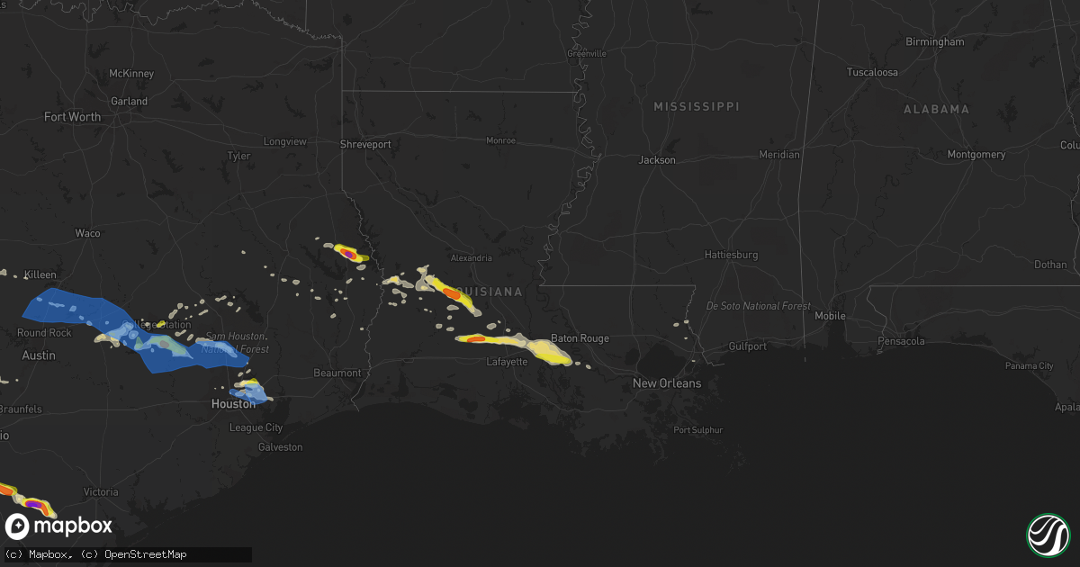
Hail Map in Louisiana on April 9, 2020
Get this storm
April 9 map
$229
one time, instant access
Download today. No call, no setup
Keep the $229
Bought the map and want the full workflow? Apply the entire $229 to a subscription within 7 days. None of it is wasted.
Every map, not just this one
This buys you this map. Subscription and you get every map we run, in the markets you choose from a few cities to whole states to nationwide. Plus real-time alerts the moment a storm fires.
Contact data
Name, contact info, occupancy, even credit band for addresses in the footprint. You go from where it hit to who to call.
Become the source they trust
Unlimited branding weather history reports on demand. You already have the documented answer ready for the property owner, and you are the one who showed up with it.
Property data and RoofTrace estimates
Pull up any address you have got, its value and the exact code rules for that jurisdiction, straight from One Click Code. Then RoofTrace estimates the squares, pitch, and roof value, priced the way you price.
Storm reports in Louisiana
Louisiana
| Date | Description |
|---|---|
| 04/09/20206:32 AM CDT | At 1131 PM CDT, a severe thunderstorm was located near East New Orleans, moving east at 35 mph. HAZARD...60 mph wind gusts. SOURCE...Radar indicated. IMPACT...Expect damage to roofs, siding, and trees. Locations impacted include... New Orleans, Chalmette, East New Orleans, Meraux, Shell Beach, Arabi and Violet. |
| 04/09/20206:23 AM CDT | At 1123 PM CDT, a severe thunderstorm was located near Pearlington, or near Slidell, moving east at 55 mph. HAZARD...60 mph wind gusts and penny size hail. SOURCE...Radar indicated. IMPACT...Expect damage to roofs, siding, and trees. Locations impacted include... New Orleans, Slidell, Bay St. Louis, Waveland, Diamondhead, East New Orleans, Lake Catherine, Pearlington, Shoreline Park, Stennis Space Center and Kiln. |
| 04/09/20204:43 AM CDT | At 943 PM CDT, severe thunderstorms were located along a line extending from near Plaquemine to near Bayou Sorrel, moving east at 35 mph. HAZARD...60 mph wind gusts and quarter size hail. SOURCE...Radar indicated. IMPACT...Hail damage to vehicles is expected. Expect wind damage to roofs, siding, and trees. Locations impacted include... Baton Rouge, Gonzales, Donaldsonville, Plaquemine, Napoleonville, Oak Hills Place, St. Gabriel, Gramercy, Addis, Lutcher, Brusly, White Castle, Sorrento, French Settlement, Port Vincent, Geismar, Bayou Sorrel, Whitehall, Old Jefferson and Paincourtville. |
| 04/09/20204:08 AM CDT | At 906 PM CDT, severe thunderstorms were located along a line extending from Ramah to near Catahoula, moving east at 40 mph. HAZARD...60 mph wind gusts and quarter size hail. SOURCE...Radar indicated. IMPACT...Hail damage to vehicles is expected. Expect wind damage to roofs, siding, and trees. Locations impacted include... Baton Rouge, Denham Springs, Plaquemine, Port Allen, Oak Hills Place, St. Gabriel, Addis, Brusly, White Castle, Rosedale, Grosse Tete, Westminster, Inniswold, Ramah, Village St. George, Bayou Sorrel, Shenandoah, Gardere, Carville and Old Jefferson. |
| 04/09/20203:39 AM CDT | At 838 PM CDT, a severe thunderstorm was located over Cecilia, or near Arnaudville, moving east at 45 mph. HAZARD...60 mph wind gusts and quarter size hail. SOURCE...Radar indicated. IMPACT...Hail damage to vehicles is expected. Expect wind damage to roofs, siding, and trees. Locations impacted include... Rosedale, Grosse Tete and Ramah. |
| 04/09/20203:34 AM CDT | At 834 PM CDT, a severe thunderstorm was located over Arnaudville, moving east at 50 mph. HAZARD...60 mph wind gusts and quarter size hail. SOURCE...Radar indicated. IMPACT...Hail damage to vehicles is expected. Expect wind damage to roofs, siding, and trees. Locations impacted include... Leonville, Arnaudville, Henderson, Butte La Rose, Cecilia, Atchafalaya Welcome Center and Atchafalaya National Wildlife Refuge.This includes Interstate 10 in Louisiana between mile markers 112 and126. |
| 04/09/20202:52 AM CDT | At 752 PM CDT, a severe thunderstorm was located near Pine Prairie, or 7 miles northwest of Ville Platte, moving southeast at 35 mph. HAZARD...60 mph wind gusts and quarter size hail. SOURCE...Radar indicated. IMPACT...Hail damage to vehicles is expected. Expect wind damage to roofs, siding, and trees. Locations impacted include... Opelousas, Ville Platte, Port Barre, Pine Prairie, Washington, Bayou Chicot, Prairie Ronde, Reddell, Indian Lake, Grand Prairie and Chicot State Park.This includes Interstate 49 between mile markers 18 and 40. |
| 04/09/20202:47 AM CDT | At 746 PM CDT, a severe thunderstorm was located near Mowata, or near Basile, moving east at 40 mph. HAZARD...60 mph wind gusts and half dollar size hail. SOURCE...Radar indicated. IMPACT...Hail damage to vehicles is expected. Expect wind damage to roofs, siding, and trees. Locations impacted include... Lafayette, Opelousas, Eunice, Scott, Carencro, Church Point, Iota, Leonville, Arnaudville, Sunset, Grand Coteau, Cankton, Mowata, Maxie, Mire, Savoy, Branch and Richard.This includes the following highways... Interstate 10 in Louisiana between mile markers 99 and 107. Interstate 49 between mile markers 1 and 17. |
| 04/09/20202:35 AM CDT | At 734 PM CDT, severe thunderstorms were located along a line extending from near Trout Creek to near Caney Head, moving east at 40 mph. HAZARD...60 mph wind gusts and nickel size hail. SOURCE...Radar indicated. IMPACT...Expect damage to roofs, siding, and trees. Locations impacted include... Lake Charles, Sulphur, Westlake, Kirbyville, Reeves, Deweyville, Moss Bluff, De Quincy, Ragley, Call, Starks, Fields, Buna, Trout Creek, Bivens, Lunita, Topsy, Gillis, Edgerly and Devils Pocket.This includes the following highways... Interstate 10 in Louisiana between mile markers 14 and 29. Interstate 210 between mile markers 1 and 2. |
| 04/09/20202:10 AM CDT | At 710 PM CDT, a severe thunderstorm was located near Oakdale, moving southeast at 35 mph. HAZARD...Two inch hail and 60 mph wind gusts. SOURCE...Radar indicated. IMPACT...People and animals outdoors will be injured. Expect hail damage to roofs, siding, windows, and vehicles. Expect wind damage to roofs, siding, and trees. Locations impacted include... Oakdale, Bond and Beaver. |
| 04/09/20201:45 AM CDT | At 645 PM CDT, a severe thunderstorm was located near Pitkin, moving southeast at 20 mph. HAZARD...60 mph wind gusts and quarter size hail. SOURCE...Radar indicated. IMPACT...Hail damage to vehicles is expected. Expect wind damage to roofs, siding, and trees. Locations impacted include... Oakdale, Elizabeth, Pitkin and Union Hill. |
| 04/09/20201:21 AM CDT | At 620 PM CDT, a severe thunderstorm was located near Pitkin, moving southeast at 30 mph. HAZARD...60 mph wind gusts and quarter size hail. SOURCE...Radar indicated. IMPACT...Hail damage to vehicles is expected. Expect wind damage to roofs, siding, and trees. Locations impacted include... Oakdale, Glenmora, Elizabeth, Allen Parish Airport, Beaver and Union Hill. |
| 04/09/20201:13 AM CDT | At 613 PM CDT, a severe thunderstorm was located 8 miles southeast of Hemphill, or 12 miles northwest of Toledo Bend Dam, moving southeast at 30 mph. HAZARD...60 mph wind gusts and quarter size hail. SOURCE...Radar indicated. IMPACT...Hail damage to vehicles is expected. Expect wind damage to roofs, siding, and trees. Locations impacted include... Leesville, Rosepine, Toledo Bend Dam, Fort Polk, Burkeville, New Llano, Burr Ferry, Mayflower, Evans, Pickering and Wiergate. |
| 04/09/202012:46 AM CDT | At 545 PM CDT, a severe thunderstorm was located near Hemphill, or 23 miles northeast of Ebenezer, moving east at 30 mph. HAZARD...Ping pong ball size hail. SOURCE...Radar indicated. IMPACT...People and animals outdoors will be injured. Expect damage to roofs, siding, windows, and vehicles. Locations impacted include... Milam, Hemphill, Pineland, Rosevine, Florien, Bronson, McElroy, Fairmount, Yellowpine and Columbus. |
| 04/09/202012:26 AM CDT | At 526 PM CDT, a severe thunderstorm was located near Lacamp, or 7 miles southeast of Slagle, moving east at 15 mph. HAZARD...60 mph wind gusts and quarter size hail. SOURCE...Radar indicated. IMPACT...Hail damage to vehicles is expected. Expect wind damage to roofs, siding, and trees. Locations impacted include... Hineston, Otis, Lacamp, Leander, Sieper and Calcasieu. |
| 04/09/202012:24 AM CDT | At 524 PM CDT, a severe thunderstorm was located near Burr Ferry, or 9 miles southwest of Leesville, moving east at 10 mph. HAZARD...60 mph wind gusts and quarter size hail. SOURCE...Radar indicated. IMPACT...Hail damage to vehicles is expected. Expect wind damage to roofs, siding, and trees. Locations impacted include... Leesville, Fort Polk, New Llano and Pickering. |
| 04/08/202011:21 PM CDT | Weatherflow station at lakefront airport gusted to 76 mph. |
| 04/08/202011:21 PM CDT | Weatherflow station at lakefront airport gusted to 76 mph. |
| 04/08/202011:15 PM CDT | Weatherflow station at mid point of pontchartrain causeway measured gust of 59 mph. |
| 04/08/202011:05 PM CDT | Tree and powerline down on dresden drive in lacombe. Road blocked. Time est from radar. |
| 04/08/202010:10 PM CDT | Delayed public report of straight line wind damage along norwood road... Near john west road in ascension parish. Atleast 3 large trees uprooted onto power lines. Trees |
| 04/08/20208:38 PM CDT | St martin em reports hail of unknown size and strong winds near cecilia. Time estimated by radar |
| 04/08/20208:30 PM CDT | Media reported trees blown down in arnaudville |
| 04/08/20208:25 PM CDT | Media reported trees blown down in sunset. |
| 04/08/20208:16 PM CDT | Public reports a tree blocking road on choupique road north of i-10. |
| 04/08/20208:15 PM CDT | Media reported trees blown down in mamou. |
| 04/08/20208:15 PM CDT | Media reported trees blown down in cecilia. |
| 04/08/20208:10 PM CDT | Opelousas pd reports widespread tree damage in the opelousas area. A woman was trapped in her home by tree damage. |
| 04/08/20208:08 PM CDT | Storm spotter reported half dollar sized hail. |
| 04/08/20208:08 PM CDT | Public reports a large tree limb down on a car at 801 w plaquemine st in church point. Time estimated by radar. |
| 04/08/20208:04 PM CDT | Spotter reported quarter sized hail in richard. |
| 04/08/20207:50 PM CDT | Public reports thunderstorm wind damage near iota. Time estimated by radar. |
| 04/08/20207:45 PM CDT | 60 mph wind gust measured by police department. |
| 04/08/20207:45 PM CDT | Reported of scattered trees down in evangeline parish. |
| 04/08/20207:35 PM CDT | Media reported a tree blown down on a car. |
| 04/08/20207:32 PM CDT | Allen parish ohsep reports scattered trees and power lines downed. |
All States Impacted by Hail Map on April 9, 2020
Cities Impacted by Hail Map on April 9, 2020
- Cotulla, TX
- Big Wells, TX
- Crystal City, TX
- Lexington, TX
- San Saba, TX
- Ville Platte, LA
- Mamou, LA
- Oakdale, LA
- Pitkin, LA
- Glenmora, LA
- Houston, TX
- Humble, TX
- Crosby, TX
- Burnet, TX
- Leesville, LA
- Deridder, LA
- Valley Spring, TX
- Brady, TX
- Lohn, TX
- Rochelle, TX
- Huntsville, TX
- Willis, TX
- Conroe, TX
- Rio Grande City, TX
- Garciasville, TX
- Mission, TX
- Grulla, TX
- Bedias, TX
- Laredo, TX
- Zapata, TX
- Hebbronville, TX
- San Ygnacio, TX
- Castroville, TX
- Mico, TX
- San Antonio, TX
- Rio Medina, TX
- Hondo, TX
- Bush, LA
- Navasota, TX
- Falls City, TX
- Caldwell, TX
- Charlotte, TX
- Pleasanton, TX
- Jourdanton, TX
- Poteet, TX
- Goliad, TX
- Beeville, TX
- Kenedy, TX
- Dime Box, TX
- Oberlin, LA
- Elton, LA
- Port Barre, LA
- Opelousas, LA
- Miles, TX
- Picayune, MS
- Encinal, TX
- Asherton, TX
- Somerville, TX
- Washington, TX
- College Station, TX
- Brenham, TX
- Church Point, LA
- Eunice, LA
- Basile, LA
- Sunset, LA
- Arnaudville, LA
- Branch, LA
- Pearsall, TX
- Blanco, TX
- Kendalia, TX
- San Marcos, TX
- Spring Branch, TX
- Fischer, TX
- Wimberley, TX
- Canyon Lake, TX
- Montgomery, TX
- Spurger, TX
- Karnes City, TX
- Campbellton, TX
- Mason, TX
- Penitas, TX
- Catarina, TX
- D Hanis, TX
- Yancey, TX
- Dilley, TX
- Fredonia, TX
- Voca, TX
- Darrow, LA
- Donaldsonville, LA
- Geismar, LA
- Slidell, LA
- Boerne, TX
- Comfort, TX
- Richland Springs, TX
- Bartlett, TX
- Granger, TX
- Thorndale, TX
- Freer, TX
- Jasper, TX
- Brookeland, TX
- Iola, TX
- Fort Polk, LA
- Breaux Bridge, LA
- Grosse Tete, LA
- Saint Martinville, LA
- Maringouin, LA
- Plaquemine, LA
- Rockdale, TX
- Bryan, TX
- Chireno, TX
- Medina, TX
- White Castle, LA
- Iota, LA
- Llano, TX
- Buchanan Dam, TX
- Anderson, TX
- Lumberton, MS
- Pineland, TX
- Bronson, TX
- Hemphill, TX
- Pearl River, LA
- San Diego, TX
- Corrigan, TX
- Junction, TX
- San Augustine, TX
- Kempner, TX
- Hunt, TX
- Mountain Home, TX
- Castell, TX
- Oakhurst, TX
- Chester, TX
- Florence, TX
- Evans, LA
- Colmesneil, TX
- Cleveland, TX
- Wiergate, TX
- Kinder, LA
- Broaddus, TX
- Melvin, TX
- New Llano, LA
- Waller, TX
- Center Point, TX
- Jarrell, TX
- Dry Creek, LA
- Apple Springs, TX
- Merryville, LA
- Plantersville, TX
- Guerra, TX
- Killeen, TX
- Channelview, TX
- Highlands, TX
- Baytown, TX
- Call, TX
- Porter, TX
- Kingwood, TX
- Doss, TX
- Harper, TX
- Pontotoc, TX
- Lampasas, TX
- New Caney, TX
- Roma, TX
- Lometa, TX
- Carville, LA
- Kennard, TX
- Trinity, TX
- Burkeville, TX
- Hillsborough, NJ
- Hockley, TX
- Pinehurst, TX
- Cameron, TX
- Gause, TX
- Thrall, TX
- Buckholts, TX
- Hempstead, TX
- Splendora, TX
- Hutto, TX
- Davilla, TX
- Rogers, TX
- Snook, TX
- Liberty Hill, TX
- Taylor, TX
- Burton, TX
- Milano, TX
- Lyons, TX
- Salado, TX
- Chappell Hill, TX
- Spring, TX
- Magnolia, TX
- Georgetown, TX
- Belton, TX
- Holland, TX
- Tomball, TX
- Deer Park, TX
- La Porte, TX
- Conowingo, MD
- Newark, DE
- Wilmington, DE
- Port Deposit, MD
- Rising Sun, MD
- Elk Mills, MD
- Pennsville, NJ
- Penns Grove, NJ
- New Castle, DE
- Darlington, MD
- Colora, MD
- Elkton, MD
- Street, MD
- North East, MD
- Oxford, PA
- Garnet Valley, PA
- Voorhees, NJ
- Paulsboro, NJ
- Crum Lynne, PA
- Peach Bottom, PA
- Media, PA
- Medford, NJ
- Glendora, NJ
- Hockessin, DE
- Vincentown, NJ
- Philadelphia, PA
- Oaklyn, NJ
- Beachwood, NJ
- Cherry Hill, NJ
- Glenolden, PA
- Sharon Hill, PA
- Bridgeport, NJ
- Woodbury Heights, NJ
- Ridley Park, PA
- Gloucester City, NJ
- Bayville, NJ
- Kirkwood, PA
- Clementon, NJ
- Mickleton, NJ
- Toms River, NJ
- Folcroft, PA
- West Berlin, NJ
- Chester, PA
- Brookhaven, PA
- Swedesboro, NJ
- Somerdale, NJ
- Mount Laurel, NJ
- Folsom, PA
- Clarksboro, NJ
- Camden, NJ
- West Grove, PA
- Swarthmore, PA
- Seaside Heights, NJ
- Thorofare, NJ
- Lincoln University, PA
- Runnemede, NJ
- Woodlyn, PA
- Lanoka Harbor, NJ
- Manchester Township, NJ
- Sewell, NJ
- Pemberton, NJ
- Marlton, NJ
- National Park, NJ
- Gibbstown, NJ
- Prospect Park, PA
- Woodbury, NJ
- Chester Heights, PA
- Ocean Gate, NJ
- Magnolia, NJ
- Drumore, PA
- Island Heights, NJ
- Westville, NJ
- Bellmawr, NJ
- Stratford, NJ
- Mount Royal, NJ
- Yorklyn, DE
- Forked River, NJ
- Pine Beach, NJ
- Landenberg, PA
- Browns Mills, NJ
- Lawnside, NJ
- Chatsworth, NJ
- Holmes, PA
- Norwood, PA
- Barrington, NJ
- Avondale, PA
- Haddon Heights, NJ
- Seaside Park, NJ
- Quarryville, PA
- Mount Ephraim, NJ
- Montchanin, DE
- Glen Mills, PA
- Audubon, NJ
- Gibbsboro, NJ
- Cochranville, PA
- Claymont, DE
- Kennett Square, PA
- Morton, PA
- Toughkenamon, PA
- Aston, PA
- Mantua, NJ
- Essington, PA
- Blackwood, NJ
- Wenonah, NJ
- Rockland, DE
- Nottingham, PA
- Collingswood, NJ
- Marcus Hook, PA
- Haddonfield, NJ
- Wallingford, PA
- Chadds Ford, PA
- Conshohocken, PA
- Newtown Square, PA
- Brielle, NJ
- Strasburg, PA
- Bridgeport, PA
- Fairless Hills, PA
- Atglen, PA
- Malvern, PA
- Lancaster, PA
- Kinzers, PA
- Thorndale, PA
- Chesterfield, NJ
- Burlington, NJ
- Devon, PA
- Gladwyne, PA
- Exton, PA
- New Egypt, NJ
- Allentown, NJ
- Honey Brook, PA
- East Earl, PA
- Immaculata, PA
- Langhorne, PA
- Wayne, PA
- Leola, PA
- Smoketown, PA
- Wrightstown, NJ
- Narvon, PA
- Bradley Beach, NJ
- Manasquan, NJ
- Jackson, NJ
- Robbinsville, NJ
- Cheltenham, PA
- Oreland, PA
- Brick, NJ
- Plymouth Meeting, PA
- Lafayette Hill, PA
- Freehold, NJ
- Elverson, PA
- Glenside, PA
- Feasterville Trevose, PA
- Roebling, NJ
- Berwyn, PA
- King Of Prussia, PA
- Oaks, PA
- Bryn Mawr, PA
- Phoenixville, PA
- Sea Girt, NJ
- Willow Grove, PA
- Trenton, NJ
- Millstone Township, NJ
- Intercourse, PA
- Blue Bell, PA
- Bryn Athyn, PA
- Millersville, PA
- Bird In Hand, PA
- Christiana, PA
- Point Pleasant Beach, NJ
- Paradise, PA
- Levittown, PA
- Downingtown, PA
- Jenkintown, PA
- Avon By The Sea, NJ
- Glenmoore, PA
- Paoli, PA
- Flourtown, PA
- Morrisville, PA
- Farmingdale, NJ
- Chester Springs, PA
- Willow Street, PA
- New Holland, PA
- Elkins Park, PA
- Fort Washington, PA
- Bensalem, PA
- Allenwood, NJ
- Wyncote, PA
- Parkesburg, PA
- Howell, NJ
- Dresher, PA
- Ambler, PA
- Florence, NJ
- Bordentown, NJ
- West Chester, PA
- Spring Lake, NJ
- Coatesville, PA
- Cream Ridge, NJ
- Abington, PA
- Lakewood, NJ
- Gordonville, PA
- Huntingdon Valley, PA
- Gap, PA
- Ronks, PA
- Croydon, PA
- Belmar, NJ
- Bristol, PA
- Neptune, NJ
- Norristown, PA
- Villanova, PA
- Southampton, PA
- Columbus, NJ
- Cranbury, NJ
- Denver, PA
- Reinholds, PA
- Monmouth Beach, NJ
- Perkiomenville, PA
- Akron, PA
- Fort Monmouth, NJ
- Gwynedd, PA
- Warrington, PA
- Shrewsbury, NJ
- Marlboro, NJ
- Mohnton, PA
- Jamison, PA
- Leonardo, NJ
- Keansburg, NJ
- Fair Haven, NJ
- Monroe Township, NJ
- Matawan, NJ
- Stevens, PA
- Birdsboro, PA
- Port Monmouth, NJ
- Gilbertsville, PA
- Oakhurst, NJ
- Englishtown, NJ
- Morgantown, PA
- Ephrata, PA
- Titusville, NJ
- Princeton Junction, NJ
- Spotswood, NJ
- Little Silver, NJ
- Plainsboro, NJ
- Hatboro, PA
- Roosevelt, NJ
- Warminster, PA
- Long Branch, NJ
- Washington Crossing, PA
- Deal, NJ
- Pennington, NJ
- Princeton, NJ
- Furlong, PA
- Pottstown, PA
- Belford, NJ
- East Brunswick, NJ
- Royersford, PA
- Colts Neck, NJ
- Zieglerville, PA
- Lansdale, PA
- Middletown, NJ
- Allenhurst, NJ
- Keyport, NJ
- Holmdel, NJ
- Spring City, PA
- Souderton, PA
- Monmouth Junction, NJ
- Hazlet, NJ
- Hightstown, NJ
- Collegeville, PA
- Doylestown, PA
- Chalfont, PA
- Hatfield, PA
- Richboro, PA
- Newtown, PA
- Windsor, NJ
- Harleysville, PA
- Highlands, NJ
- Morganville, NJ
- Atlantic Highlands, NJ
- Lawrence Township, NJ
- Schwenksville, PA
- West Long Branch, NJ
- North Wales, PA
- Red Bank, NJ
- Rumson, NJ
- Asbury Park, NJ
- Eatontown, NJ
- Oceanport, NJ
- Boyertown, PA
- Horsham, PA
- Montgomeryville, PA
- Skippack, PA
- New Hope, PA
- Old Bridge, NJ
- Hilltown, PA
- Colmar, PA
- Terre Hill, PA
- Helmetta, NJ
- Line Lexington, PA
- Ocean Grove, NJ
- Douglassville, PA
- Dayton, NJ
- Lincroft, NJ
- Telford, PA
- East Setauket, NY
- North Babylon, NY
- Woodhaven, NY
- Coram, NY
- Old Bethpage, NY
- Water Mill, NY
- Northport, NY
- Pittstown, NJ
- Kew Gardens, NY
- Island Park, NY
- Middle Island, NY
- Colonia, NJ
- Edison, NJ
- Bethpage, NY
- Long Beach, NY
- West Kingston, RI
- Commack, NY
- Great River, NY
- Plymouth, MA
- Farmingdale, NY
- West Barnstable, MA
- Fresh Meadows, NY
- Iselin, NJ
- Ronkonkoma, NY
- Tiverton, RI
- Neshanic Station, NJ
- Dunellen, NJ
- Bellport, NY
- Portsmouth, RI
- Mineola, NY
- Shelter Island Heights, NY
- Manville, NJ
- North Brunswick, NJ
- Moriches, NY
- Rahway, NJ
- Brooklyn, NY
- Marstons Mills, MA
- Middletown, RI
- Mashpee, MA
- Saint James, NY
- Holtsville, NY
- Stony Brook, NY
- Cedarhurst, NY
- Garden City, NY
- Marion, MA
- Yaphank, NY
- Jamestown, RI
- Albertson, NY
- Jamaica, NY
- Hauppauge, NY
- Milltown, NJ
- Holbrook, NY
- Piscataway, NJ
- Stockton, NJ
- Clark, NJ
- Scotch Plains, NJ
- Belle Mead, NJ
- North Falmouth, MA
- Centerville, MA
- Oakland Gardens, NY
- Medford, NY
- Flushing, NY
- South Bound Brook, NJ
- Far Rockaway, NY
- Lynbrook, NY
- Roslyn Heights, NY
- Huntington Station, NY
- Jericho, NY
- Woodbridge, NJ
- Cutchogue, NY
- Manhasset, NY
- Middle Village, NY
- Acushnet, MA
- Brightwaters, NY
- Calverton, NY
- Kendall Park, NJ
- Port Jefferson Station, NY
- Raritan, NJ
- Stonington, CT
- Little Compton, RI
- Inwood, NY
- Wyandanch, NY
- Lawrence, NY
- Mattituck, NY
- Oakdale, NY
- East Marion, NY
- Cotuit, MA
- Avenel, NJ
- Mastic, NY
- Westerly, RI
- Bay Shore, NY
- Fairhaven, MA
- Roosevelt, NY
- Orient, NY
- North Dartmouth, MA
- Massapequa, NY
- Oceanside, NY
- Cataumet, MA
- Cold Spring Harbor, NY
- West Hempstead, NY
- Queens Village, NY
- Farmingville, NY
- Westfield, NJ
- Howard Beach, NY
- Syosset, NY
- Metuchen, NJ
- Sagamore Beach, MA
- Glen Oaks, NY
- Mount Sinai, NY
- Hempstead, NY
- Wantagh, NY
- Center Moriches, NY
- Islandia, NY
- Pipersville, PA
- Freeport, NY
- Wading River, NY
- East Islip, NY
- Skillman, NJ
- Sayreville, NJ
- Cambria Heights, NY
- Kingston, RI
- Fishers Island, NY
- Smithtown, NY
- East Sandwich, MA
- New Hyde Park, NY
- Hicksville, NY
- Baldwin, NY
- Southampton, NY
- Greenport, NY
- Keasbey, NJ
- Charlestown, RI
- Woodmere, NY
- Central Islip, NY
- Pocasset, MA
- Ozone Park, NY
- Onset, MA
- Levittown, NY
- Westport, MA
- Atlantic Beach, NY
- Fords, NJ
- Rockville Centre, NY
- Malverne, NY
- Nesconset, NY
- Rockaway Park, NY
- Saint Albans, NY
- Hampton Bays, NY
- Laurel, NY
- Woods Hole, MA
- East Wareham, MA
- Whitehouse Station, NJ
- Elizabeth, NJ
- South Amboy, NJ
- Deer Park, NY
- Lumberville, PA
- Merrick, NY
- New Bedford, MA
- Brentwood, NY
- Copiague, NY
- Parlin, NJ
- Brookhaven, NY
- East Rockaway, NY
- Elmont, NY
- Mystic, CT
- Arverne, NY
- Patchogue, NY
- Seaford, NY
- South Richmond Hill, NY
- South Ozone Park, NY
- Islip Terrace, NY
- Pawcatuck, CT
- East Northport, NY
- Port Jefferson, NY
- Southold, NY
- Highland Park, NJ
- New Brunswick, NJ
- Cuttyhunk, MA
- Greenlawn, NY
- Point Pleasant, PA
- Manorville, NY
- Lambertville, NJ
- Old Westbury, NY
- Hyannis, MA
- South Jamesport, NY
- Amityville, NY
- Shoreham, NY
- Perth Amboy, NJ
- Bradford, RI
- Newport, RI
- Fall River, MA
- Bayport, NY
- Melville, NY
- Linden, NJ
- Selden, NY
- Saunderstown, RI
- Bellmore, NY
- South River, NJ
- Centereach, NY
- Elizabethport, NJ
- Sound Beach, NY
- Frenchtown, NJ
- Rego Park, NY
- Somerville, NJ
- Cranford, NJ
- Somerset, NJ
- Richmond Hill, NY
- Carteret, NJ
- West Islip, NY
- East Meadow, NY
- Huntington, NY
- Floral Park, NY
- Rocky Point, NY
- Jamesport, NY
- Riverhead, NY
- Groton, CT
- Bayonne, NJ
- Westbury, NY
- East Quogue, NY
- Wakefield, RI
- Flagtown, NJ
- Blue Point, NY
- New Suffolk, NY
- East Hampton, NY
- Three Bridges, NJ
- Ridge, NY
- Lake Grove, NY
- West Sayville, NY
- Warren, NJ
- Buzzards Bay, MA
- Bridgewater, NJ
- Westport Point, MA
- Breezy Point, NY
- Plainview, NY
- Mattapoisett, MA
- Great Neck, NY
- Flemington, NJ
- Rosedale, NY
- Springfield Gardens, NY
- Port Reading, NJ
- Babylon, NY
- Carle Place, NY
- Peconic, NY
- Miller Place, NY
- Wareham, MA
- East Falmouth, MA
- Forest Hills, NY
- Shelter Island, NY
- Forestdale, MA
- Falmouth, MA
- Franklin Square, NY
- Narragansett, RI
- Ringoes, NJ
- South Dartmouth, MA
- Middlesex, NJ
- Glen Head, NY
- Hewlett, NY
- Sayville, NY
- Ridgewood, NY
- Osterville, MA
- South Plainfield, NJ
- Plainfield, NJ
- Franklin Park, NJ
- Sandwich, MA
- Sag Harbor, NY
- Islip, NY
- Lindenhurst, NY
- Kings Park, NY
- Williston Park, NY
- Woodbury, NY
- West Babylon, NY
- Sagamore, MA
- Staten Island, NY
- Sewaren, NJ
- Uniondale, NY
- Martinsville, NJ
- Little Neck, NY
- Roslyn, NY
- Shirley, NY
- Bellerose, NY
- Roselle, NJ
- Hopewell, NJ
- Valley Stream, NY
- Hollis, NY
- Bound Brook, NJ
- Massapequa Park, NY
- Bohemia, NY
- Rocky Hill, NJ
- Batesville, TX
- Huffman, TX


