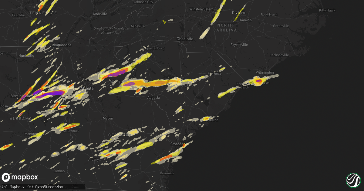
Hail Map in South Carolina on April 5, 2017
Get this storm
April 5 map
$229
one time, instant access
Download today. No call, no setup
Keep the $229
Bought the map and want the full workflow? Apply the entire $229 to a subscription within 7 days. None of it is wasted.
Every map, not just this one
This buys you this map. Subscription and you get every map we run, in the markets you choose from a few cities to whole states to nationwide. Plus real-time alerts the moment a storm fires.
Contact data
Name, contact info, occupancy, even credit band for addresses in the footprint. You go from where it hit to who to call.
Become the source they trust
Unlimited branding weather history reports on demand. You already have the documented answer ready for the property owner, and you are the one who showed up with it.
Property data and RoofTrace estimates
Pull up any address you have got, its value and the exact code rules for that jurisdiction, straight from One Click Code. Then RoofTrace estimates the squares, pitch, and roof value, priced the way you price.
Storm reports in South Carolina
South Carolina
| Date | Description |
|---|---|
| 04/05/20176:59 PM CDT | 1.25 to 1.5 inch hail |
| 04/05/20176:55 PM CDT | Spotter reported quarter size hail in carolina bay. |
| 04/05/20176:55 PM CDT | A local report indicates 1.00 inch wind near 3 S SHADOWMOSS |
| 04/05/20176:55 PM CDT | Downpour of hail up to the size of quarters...most of it falling as dime to nickel size. |
| 04/05/20176:04 PM CDT | Schp reported a tree on the roadway near the intersection of highway 17 and wiggins road. |
| 04/05/20175:00 PM CDT | Relayed by media. |
| 04/05/20174:46 PM CDT | Power lines down on sc highway 9 near pee dee church road. |
| 04/05/20174:10 PM CDT | Power lines down on sc highway 9 near pee dee church road. |
| 04/05/20174:00 PM CDT | *** 1 inj *** oak tree fell into home. Two vehicles damaged. One child injured and sent to hospital in florence. Hail of unknown size fell. |
| 04/05/20173:50 PM CDT | Media relayed report of brief period of quarter sized hail. |
| 04/05/20173:06 PM CDT | Quarter sized hail just south of u.s. Highway 76 and east lynches river road. |
| 04/05/20172:33 PM CDT | Half dollar sized hail photographed near dalzell... Sc. |
| 04/05/20172:21 PM CDT | Schp reports trees in roadway 1735 hatchaway bridge road at langdon road. |
| 04/05/20171:46 PM CDT | County reported power lines down at garner's ferry and trotter road. |
| 04/05/20171:45 PM CDT | A social media report through local broadcast media of a tree uprooted and landed on a small shed. Along with a nearby large hardwood tree snapped. |
| 04/05/20171:35 PM CDT | A local report indicates 1.75 inch wind near 9 WSW REMBERT |
| 04/05/20171:23 PM CDT | 68 mph wind gust recorded at the columbia metropolitan airport |
| 04/05/20171:22 PM CDT | Reported a couple small trees down near the platt springs road entrance to the columbia metro airport. |
| 04/05/20171:21 PM CDT | Tree down blocking roadway dogwood trail at woodside road. |
| 04/05/20171:20 PM CDT | Public reported golf ball size hail at the enterprise car lot near the columbia metropolitan airport. |
| 04/05/20171:18 PM CDT | A local report indicates 1.75 inch wind near 2 SE LEXINGTON |
| 04/05/20171:12 PM CDT | Trees blocking highway. |
| 04/05/20171:09 PM CDT | Social media picture through broadcast media of a tree down across railroad avenue in lexington. |
| 04/05/20171:06 PM CDT | Uprooted tree at intersection of rollingwood drive and old cherokee road. Brief touchdown. |
| 04/05/201712:50 PM CDT | Broadcast media reported with images significant wind damage to a mobile home in gilbert. Radar indicated a possible tornado in the area. |
| 04/05/201712:46 PM CDT | Amateur radio operator reported ping-pong ball size hail on main street in beatesburg-leesville... Sc. |
| 04/05/201712:45 PM CDT | Numerous trees down hwy 23 between ward and ridge spring blocking roadway. |
| 04/05/201712:35 PM CDT | Aiken county sheriff reported tornado in monetta with several trees down. |
| 04/05/201712:30 PM CDT | Trees down near the first baptist church. |
| 04/05/201712:30 PM CDT | Trained spotter reported multiple trees down on cars in dealership lot.. Several cars damaged. |
| 04/05/201712:25 PM CDT | Trees down near the first baptist church. |
| 04/05/201712:25 PM CDT | County em reported tree down on house. |
| 04/05/201712:22 PM CDT | Grain silo heavily damaged and multiple trees along with power lines down at hwy 39 and murphy farm road. |
| 04/05/201712:19 PM CDT | *** 1 inj *** nws survey team confirmed tornado damage on the east side of johnston near winthrow avenue and continued northeast through ward before dissipating northwe |
| 04/05/201712:19 PM CDT | Trees blocking road. |
| 04/05/201712:18 PM CDT | Trees down. |
| 04/05/201712:13 PM CDT | Roof blown off furniture store. |
| 04/05/201711:53 AM CDT | Media via social media posted image of 1 inch hail in newberry. |
| 04/05/201711:27 AM CDT | Ongoing large hail and gusty winds at hwy 81 and morrah bridge road. |
| 04/05/201712:59 AM CDT | Roof damage on sc highway 413. |
| 04/05/201712:04 AM CDT | Schp reported a tree down at horseshoe rd and princeton highway |
| 04/04/201711:55 PM CDT | Emergency mngr reported trees down on old emerson bridge rd. At hwy 185 |
| 04/04/201711:55 PM CDT | Schp reported a tree down at stagecoach rd and tomahawk ln |
| 04/04/201711:54 PM CDT | Emergency mngr reported trees down on middleton rd. |
| 04/04/201711:51 PM CDT | Emergency mngr reported a tree down on charles beaty rd |
| 04/04/201711:51 PM CDT | Emergency mngr reported trees down on pruitt rd |
| 04/04/201711:51 PM CDT | Schp reported a tree down at highway 252 and mill ham dr |
| 04/04/201711:51 PM CDT | Emergency mngr reported trees down on fred dean rd |
| 04/04/201711:51 PM CDT | Emergency mngr reported trees down on parker bowie rd. |
| 04/04/201711:49 PM CDT | Schp reported a tree down at harris bridge rd and boggy branch rd |
| 04/04/201711:45 PM CDT | Schp reported a tree down at ekom beach rd poplar springs rd and indian mound rd |
| 04/04/201711:45 PM CDT | Schp reported a tree down on poole st |
| 04/04/201711:45 PM CDT | Trees blown down in the campobello area. |
| 04/04/201711:42 PM CDT | Emergency mngr reported tree down on house on standing springs rd |
| 04/04/201711:42 PM CDT | Quarter sized hail. |
| 04/04/201711:35 PM CDT | Emergency mngr reported a tree down on pine dr in piedmont. |
| 04/04/201711:31 PM CDT | Schp reported a tree down at old gunter rd and bessie rd |
| 04/04/201711:30 PM CDT | 911 call center reported numerous trees blown down in the town of honea path...with main st still blocked and closed by fallen trees. |
| 04/04/201711:30 PM CDT | Public reported a tree down destroying a deck and a pool on blue forest ln. |
| 04/04/201711:28 PM CDT | At least a dozen trees down along williams road. |
| 04/04/201711:26 PM CDT | Public reported at least 18 trees snapped or uprooted across several properties along robinwood ln. Strong winds lifted off an outbuilding roof and at least a couple of |
| 04/04/201711:25 PM CDT | Schp reported a tree down at highway 252 and griffin farm rd |
| 04/04/201711:20 PM CDT | Fire dept/rescue reported trees and power lines down on highway 28s. |
| 04/04/201711:20 PM CDT | Fire dept/rescue reported trees and power lines down on due west hwy. |
| 04/04/201711:20 PM CDT | Schp reported a tree down at due west highway and old emerson bridge rd |
| 04/04/201711:17 PM CDT | Emergency mngr reported numerous trees down blocking hwy 81 at the starr fire department. |
| 04/04/201711:17 PM CDT | Emergency mngr reported numerous trees down in starr. |
| 04/04/201711:16 PM CDT | Schp reported a tree down at wright school rd and highway 28 |
| 04/04/201711:16 PM CDT | Anderson regional airport asos reported a wind gust of 70 mph |
| 04/04/201711:16 PM CDT | Schp reported a tree down at rainey rd and devonshire rd |
| 04/04/201711:15 PM CDT | Em reports damage to structures trees and power lines. At least one roof reportedly torn off structure. Roadway is blocked in both directions. No injuries reported. |
| 04/04/201711:15 PM CDT | At least 6 large trees twisted and snapped off... And at least 6 large trees uprooted... Most in the same area along carradine road. |
| 04/04/201711:15 PM CDT | Emergency mngr reported numerous trees and powerlines down on hwy 81 south at clyde arnold rd. |
| 04/04/201711:13 PM CDT | Schp reported a tree down at carrington ln and parker bowie rd |
| 04/04/201711:07 PM CDT | Fire dept reported a storage building roof blown off on walnut hill dr. |
| 04/04/201711:05 PM CDT | Amateur radio reported metal roof blown off abandoned building at sc hwy 253 and sc hwy 290. |
| 04/04/20177:20 PM CDT | Large tree down in the moss park area. |
| 04/04/20177:04 PM CDT | Observed near the intersection of highway 61 and glenn mcconnell parkway. |
| 04/04/20177:00 PM CDT | A local report indicates 1.25 inch wind near WEST ASHLEY |
| 04/04/20177:00 PM CDT | Social media picture indicated hail larger that quarter sized fell on indaba way. |
All States Impacted by Hail Map on April 5, 2017
Cities Impacted by Hail Map on April 5, 2017
- Wray, GA
- Ambrose, GA
- Fitzgerald, GA
- Broxton, GA
- Ocilla, GA
- Oak Island, NC
- Harned, KY
- Hardinsburg, KY
- Webster, KY
- Mammoth Cave, KY
- Bee Spring, KY
- Lineville, AL
- Dunmor, KY
- Belton, KY
- Morgantown, KY
- Orlinda, TN
- Rockfield, KY
- Woodburn, KY
- Oakland, KY
- Bowling Green, KY
- Brownsville, KY
- Springfield, TN
- Smiths Grove, KY
- Franklin, KY
- Park City, KY
- Gulf Breeze, FL
- Gordonsville, TN
- Moss, TN
- Watertown, TN
- Whitleyville, TN
- Carthage, TN
- Riddleton, TN
- Tompkinsville, KY
- Hartsville, TN
- Lafayette, TN
- Red Boiling Springs, TN
- Brush Creek, TN
- Lebanon, TN
- Elmwood, TN
- Pleasant Shade, TN
- Dixon Springs, TN
- Atlanta, GA
- Durham, NC
- Georgetown, SC
- Nesmith, SC
- Kingstree, SC
- Andrews, SC
- Hemingway, SC
- Waleska, GA
- Midland City, AL
- Newville, AL
- Lake View, SC
- Fairmont, NC
- Sonora, KY
- Upton, KY
- Dillon, SC
- Latta, SC
- Sellers, SC
- Farmersville, OH
- Centre, AL
- Vandalia, OH
- Stamping Ground, KY
- Georgetown, KY
- Midway, KY
- Sadieville, KY
- Frankfort, KY
- Leesville, SC
- Gaston, SC
- Pelion, SC
- Wagener, SC
- Lexington, SC
- Shelbyville, KY
- Bagdad, KY
- New Salisbury, IN
- Ramsey, IN
- Palmyra, IN
- Depauw, IN
- Winchester, KY
- Clay City, KY
- Jeffersonville, KY
- Adairville, KY
- Clayton, AL
- Clio, AL
- Ariton, AL
- Louisville, AL
- Shaw Afb, SC
- Rembert, SC
- Wedgefield, SC
- Cayce, SC
- Dalzell, SC
- Eastover, SC
- Hopkins, SC
- Columbia, SC
- West Columbia, SC
- Sumter, SC
- Gilbert, SC
- Birmingham, AL
- Leeds, AL
- Scottsville, KY
- Holland, KY
- Westminster, SC
- Seneca, SC
- Jacksonville, AL
- Reidsville, GA
- Uvalda, GA
- Hazlehurst, GA
- Lyons, GA
- Central, SC
- Roundhill, KY
- Cub Run, KY
- Clarkson, KY
- Sweeden, KY
- Anniston, AL
- Munford, AL
- Oxford, AL
- Talladega, AL
- Eastaboga, AL
- Eminence, KY
- Bethlehem, KY
- Lockport, KY
- Pleasureville, KY
- Owenton, KY
- Camden, AL
- Arabi, GA
- Ashburn, GA
- Alvaton, KY
- Midway, GA
- Prospect Hill, NC
- Leasburg, NC
- Pike Road, AL
- Gordon, AL
- Vincent, AL
- Sterrett, AL
- Glenwood, GA
- Soperton, GA
- Adrian, GA
- Dublin, GA
- Rockledge, GA
- East Dublin, GA
- Columbiana, AL
- Chelsea, AL
- Wilsonville, AL
- Greensburg, KY
- Thomson, GA
- Cedar Bluff, AL
- Piedmont, AL
- Gaylesville, AL
- Cordele, GA
- Riceville, TN
- Athens, TN
- Buffalo Valley, TN
- Silver Point, TN
- Bloomington, IN
- Bolivia, NC
- Supply, NC
- Starr, SC
- Canon, GA
- Danielsville, GA
- Pendergrass, GA
- Winder, GA
- Commerce, GA
- Hull, GA
- Dewy Rose, GA
- Talmo, GA
- Dacula, GA
- Gillsville, GA
- Jefferson, GA
- Auburn, GA
- Bowersville, GA
- Carnesville, GA
- Royston, GA
- Braselton, GA
- Buford, GA
- Iva, SC
- Gainesville, GA
- Hartwell, GA
- Lawrenceville, GA
- Hoschton, GA
- Maysville, GA
- Bowman, GA
- Flowery Branch, GA
- Lumpkin, GA
- Georgetown, GA
- Morris, GA
- Payneville, KY
- Brandenburg, KY
- Madison, GA
- Stephens, GA
- Greensboro, GA
- Watkinsville, GA
- Union Point, GA
- Newport, KY
- California, KY
- Cincinnati, OH
- Latonia, KY
- Batavia, OH
- New Richmond, OH
- Alexandria, KY
- Melbourne, KY
- Amelia, OH
- Morning View, KY
- Dayton, OH
- Rhine, GA
- Mount Orab, OH
- Fayetteville, OH
- Sardinia, OH
- Lynchburg, OH
- Roanoke, AL
- Wadley, AL
- Graham, AL
- Daviston, AL
- Alexander City, AL
- Bowdon, GA
- Woodland, AL
- Wedowee, AL
- Lincolnton, GA
- Lithia Springs, GA
- Douglasville, GA
- Austell, GA
- Winston, GA
- Gadsden, AL
- Wellington, AL
- Ohatchee, AL
- Muscadine, AL
- Bremen, GA
- Carrollton, GA
- Delta, AL
- Heflin, AL
- Waco, GA
- Ranburne, AL
- Elberton, GA
- Troy, SC
- Mount Carmel, SC
- McCormick, SC
- Carlton, GA
- Lexington, GA
- Rayle, GA
- Washington, GA
- Tignall, GA
- Sutherlin, VA
- Gibsonville, NC
- Milton, NC
- Pleasant Garden, NC
- Franklinville, NC
- Julian, NC
- Burlington, NC
- Climax, NC
- Liberty, NC
- Greensboro, NC
- Blanch, NC
- Alton, VA
- South Boston, VA
- Whitsett, NC
- Elon, NC
- Randleman, NC
- Yanceyville, NC
- McLeansville, NC
- Asheboro, NC
- Reidsville, NC
- Ringgold, VA
- Lakeland, GA
- Trussville, AL
- Rebecca, GA
- Sycamore, GA
- Rochelle, GA
- Lake Panasoffkee, FL
- Wildwood, FL
- Leitchfield, KY
- Temple, GA
- Villa Rica, GA
- Dallas, GA
- Dozier, AL
- Jemison, AL
- West Blocton, AL
- Vance, AL
- Woodstock, AL
- Bethel, OH
- Decherd, TN
- Ash, NC
- Southport, NC
- Carolina Beach, NC
- Shallotte, NC
- Wilmington, NC
- Sunset Beach, NC
- Longwood, NC
- Winnabow, NC
- Calabash, NC
- Ocean Isle Beach, NC
- Longs, SC
- Little River, SC
- Palmetto, GA
- Ranger, GA
- Fairmount, GA
- Versailles, KY
- Bradfordsville, KY
- Anderson, SC
- Lilburn, GA
- Oakwood, GA
- Alpharetta, GA
- Norcross, GA
- Cumming, GA
- Comer, GA
- Nicholson, GA
- Grayson, GA
- Tucker, GA
- Suwanee, GA
- Snellville, GA
- Defuniak Springs, FL
- Niceville, FL
- Holly Hill, SC
- Harleyville, SC
- Homerville, GA
- Naylor, GA
- Cochran, GA
- Baxter, TN
- Smithville, TN
- Cookeville, TN
- Gainesboro, TN
- Hilham, TN
- Bloomington Springs, TN
- Adams Run, SC
- Jacksonboro, SC
- Green Pond, SC
- Round O, SC
- Hernando, FL
- Dunnellon, FL
- Lexington, KY
- Nicholasville, KY
- Waco, KY
- Mount Sterling, KY
- Lancaster, KY
- Richmond, KY
- Brewton, AL
- Owingsville, KY
- Olympia, KY
- Salt Lick, KY
- Jesup, GA
- Richmond Hill, GA
- Riceboro, GA
- Savannah, GA
- Townsend, GA
- Ludowici, GA
- Fayetteville, TN
- Petersburg, TN
- Wartrace, TN
- Normandy, TN
- Manchester, TN
- Shelbyville, TN
- Tullahoma, TN
- Garfield, KY
- Irvington, KY
- McDaniels, KY
- Falls Of Rough, KY
- Westview, KY
- Eaton, OH
- Germantown, OH
- Bath, IN
- Hamilton, OH
- Middletown, OH
- West Alexandria, OH
- West College Corner, IN
- Miamisburg, OH
- Oxford, OH
- New Lebanon, OH
- Camden, OH
- Brookville, IN
- Tipp City, OH
- Fairborn, OH
- College Corner, OH
- Brookville, OH
- Somerville, OH
- Branchville, SC
- Cope, SC
- Bradyville, TN
- Woodbury, TN
- Inman, SC
- Lyman, SC
- Wellford, SC
- Alapaha, GA
- Willacoochee, GA
- Appling, GA
- Springville, AL
- Odenville, AL
- Frenchburg, KY
- Lithia, FL
- Conway, SC
- Palestine, WV
- Elizabeth, WV
- Bessemer, AL
- Bell Buckle, TN
- Murfreesboro, TN
- Christiana, TN
- Mulberry, FL
- Boston, KY
- Bardstown, KY
- Morehead, KY
- Wallingford, KY
- Liberty, KY
- Salem, IN
- Fredericksburg, IN
- Pekin, IN
- Corydon, IN
- Monetta, SC
- Ward, SC
- Modoc, SC
- Batesburg, SC
- Ridge Spring, SC
- Saluda, SC
- Edgefield, SC
- Johnston, SC
- Plum Branch, SC
- Williamsburg, OH
- Dexter, GA
- Cadwell, GA
- Smithville, GA
- Leesburg, GA
- Lincoln, AL
- Riverside, AL
- Pell City, AL
- Ragland, AL
- Alexandria, AL
- Saint Petersburg, FL
- Winchester, TN
- Estillfork, AL
- Cowan, TN
- Belvidere, TN
- Sewanee, TN
- Means, KY
- Bamberg, SC
- Olar, SC
- Ehrhardt, SC
- Dry Ridge, KY
- Crittenden, KY
- Marianna, FL
- Cottondale, FL
- Coy, AL
- Pine Hill, AL
- Fairfield, KY
- Elizabethtown, KY
- Lebanon Junction, KY
- Bloomfield, KY
- Taylorsville, KY
- Coxs Creek, KY
- Gurley, AL
- Huntsville, AL
- Rochester, KY
- Lewisburg, KY
- Leesburg, OH
- Greenfield, OH
- Decatur, GA
- Jakin, GA
- Moody, AL
- Summersville, KY
- Horse Branch, KY
- Cromwell, KY
- Lancaster, SC
- Pine Apple, AL
- Roswell, GA
- Weston, GA
- Dawson, GA
- Preston, GA
- Cuthbert, GA
- Richland, GA
- Parrott, GA
- Butler, KY
- Moscow, OH
- Hillsboro, OH
- Roopville, GA
- Georgetown, IN
- Lanesville, IN
- Senoia, GA
- Brooks, GA
- Peachtree City, GA
- Hampton, GA
- Fayetteville, GA
- Griffin, GA
- Beverly Hills, FL
- Brooksville, FL
- Lecanto, FL
- Inverness, FL
- Homosassa, FL
- Crystal River, FL
- Walterboro, SC
- Easley, SC
- Charleston, SC
- North Charleston, SC
- Opelika, AL
- Auburn, AL
- Pendleton, SC
- Galatia, IL
- Macedonia, IL
- Elba, AL
- Le Roy, WV
- Sandyville, WV
- Lodge, SC
- Sharpsburg, GA
- Newnan, GA
- Union City, GA
- Riverdale, GA
- Fairburn, GA
- Whitesburg, GA
- Tyrone, GA
- Rockford, AL
- Bishopville, SC
- Elliott, SC
- Lynchburg, SC
- Mayesville, SC
- Ramer, AL
- Montgomery, AL
- Letohatchee, AL
- Hope Hull, AL
- Franklin, GA
- McLeansboro, IL
- Milltown, IN
- Leavenworth, IN
- Collinsville, AL
- Fort Payne, AL
- Claxton, GA
- Lumber City, GA
- Collins, GA
- Baxley, GA
- Valley Head, AL
- Cataula, GA
- Waverly Hall, GA
- Ellerslie, GA
- Midland, GA
- Salem, AL
- Smiths Station, AL
- Phenix City, AL
- Columbus, GA
- Fortson, GA
- Johns Island, SC
- Hollywood, SC
- Mount Pleasant, SC
- Ravenel, SC
- Brooklet, GA
- Pembroke, GA
- Simpsonville, SC
- Lebanon, KY
- Gravel Switch, KY
- Campbellsville, KY
- Pineville, SC
- Saint Stephen, SC
- Rineyville, KY
- Shepherdsville, KY
- Big Clifty, KY
- Eastview, KY
- Cecilia, KY
- Glendale, KY
- Lafayette, AL
- Camp Hill, AL
- Ashland, AL
- Millerville, AL
- Goodwater, AL
- Grantville, GA
- Moreland, GA
- Magnolia, KY
- Bonnieville, KY
- Munfordville, KY
- Mount Sherman, KY
- Cross Plains, TN
- Cottontown, TN
- White House, TN
- McKenzie, AL
- Dadeville, AL
- Jacksons Gap, AL
- Lagrange, GA
- Five Points, AL
- Lanett, AL
- Sylvester, GA
- Pulaski, GA
- Metter, GA
- Springfield, GA
- Guyton, GA
- Burkesville, KY
- Albany, KY
- Buchanan, GA
- Tallapoosa, GA
- Cropwell, AL
- Harpersville, AL
- Fruithurst, AL
- Childersburg, AL
- Alpine, AL
- Tybee Island, GA
- Glasgow, KY
- Whitwell, TN
- Millry, AL
- State Line, MS
- Fountain Inn, SC
- Mount Washington, KY
- Cheshire, OH
- Apple Grove, WV
- Clemson, SC
- Townville, SC
- Steele, AL
- Helena, AL
- Attalla, AL
- Ashville, AL
- Perry, FL
- Varnville, SC
- Greenville, IN
- Memphis, IN
- Borden, IN
- Floyds Knobs, IN
- Henryville, IN
- Troy, NC
- New London, NC
- Badin, NC
- Albemarle, NC
- Shellman, GA
- Eufaula, AL
- Plains, GA
- Americus, GA
- Folkston, GA
- Apollo Beach, FL
- Ruskin, FL
- Abbeville, SC
- Greenwood, SC
- Glencoe, KY
- Jonesville, KY
- De Mossville, KY
- Falmouth, KY
- Corinth, KY
- Williamstown, KY
- Simpsonville, KY
- Powder Springs, GA
- Hiram, GA
- Bowling Green, FL
- Bartow, FL
- Homeland, FL
- Bradley, FL
- Mentone, AL
- Brundidge, AL
- Troy, AL
- Glenwood, AL
- Chester, GA
- Hawkinsville, GA
- Vidalia, GA
- Mount Vernon, GA
- Ailey, GA
- Tarrytown, GA
- Greensburg, IN
- Warwick, GA
- Abbeville, GA
- Horse Cave, KY
- Cave City, KY
- Hardyville, KY
- Elk Horn, KY
- Center, KY
- Springfield, OH
- South Vienna, OH
- Lyerly, GA
- Montevallo, AL
- Pelham, AL
- Alabaster, AL
- Brierfield, AL
- Poulan, GA
- Jacksonville, GA
- Milan, GA
- Oakfield, GA
- Swansea, SC
- Olive Hill, KY
- Bradley, SC
- Calhoun, GA
- Greensboro, AL
- Emerson, KY
- Grayson, KY
- Hillsboro, KY
- Stanton, KY
- Clearfield, KY
- Vanceburg, KY
- Hope, KY
- Williamston, SC
- Georgiana, AL
- Evergreen, AL
- Cobbtown, GA
- Kure Beach, NC
- North Myrtle Beach, SC
- Monroe, GA
- Loganville, GA
- Caneyville, KY
- Fordsville, KY
- Olaton, KY
- Guston, KY
- Beaver Dam, KY
- Morrison, TN
- Timmonsville, SC
- Florence, SC
- Darlington, SC
- Shorter, AL
- Rentz, GA
- Swainsboro, GA
- Pedro, OH
- North, SC
- Orangeburg, SC
- Saint Matthews, SC
- Oakboro, NC
- Norwood, NC
- Horton, AL
- Gainestown, AL
- Jackson, AL
- Talbotton, GA
- Enterprise, AL
- Talking Rock, GA
- Old Town, FL
- Sumner, GA
- Ty Ty, GA
- Tifton, GA
- Hodges, SC
- Dowelltown, TN
- Valley, AL
- Cedartown, GA
- Rockmart, GA
- Athens, GA
- Winterville, GA
- Bishop, GA
- Fairfax, SC
- Brunson, SC
- Ulmer, SC
- Allons, TN
- Livingston, TN
- Byrdstown, TN
- Celina, TN
- Hardeeville, SC
- Rincon, GA
- Granite Falls, NC
- Connelly Springs, NC
- Hickory, NC
- Merritt Island, FL
- Melbourne, FL
- Cocoa Beach, FL
- Cape Canaveral, FL
- Rockledge, FL
- Chattanooga, TN
- Douglas, GA
- Lenox, GA
- Nashville, GA
- Marietta, GA
- Grove Hill, AL
- Nashville, IN
- Maplesville, AL
- Register, GA
- McRae Helena, GA
- Pitts, GA
- Statesboro, GA
- Glennville, GA
- Clyo, GA
- Denton, GA
- Ellabell, GA
- Tillman, SC
- Garnett, SC
- Greenbrier, TN
- Knifley, KY
- Knob Lick, KY
- Gradyville, KY
- Mannsville, KY
- Edmonton, KY
- Dunnville, KY
- Columbia, KY
- Portland, TN
- Frisco City, AL
- Uriah, AL
- Cave Spring, GA
- New Market, AL
- Stevenson, AL
- Sherwood, TN
- Tracy City, TN
- Scottsboro, AL
- Princeton, AL
- South Pittsburg, TN
- Signal Mountain, TN
- Sequatchie, TN
- Dunlap, TN
- Fackler, AL
- Brownsboro, AL
- Wadmalaw Island, SC
- Edisto Island, SC
- Jasper, TN
- Pisgah, AL
- Flat Rock, AL
- Higdon, AL
- Ider, AL
- Henagar, AL
- Graysville, TN
- Statham, GA
- Trenton, GA
- Wildwood, GA
- Yemassee, SC
- Lumberton, NC
- Aiken, SC
- Lamar, SC
- Gadsden, SC
- Pelzer, SC
- Belton, SC
- Piedmont, SC
- Greenville, SC
- Mcminnville, TN
- Lawrenceburg, KY
- Waddy, KY
- Raywick, KY
- Blenheim, SC
- Middleburg, KY
- Repton, AL
- Calhoun Falls, SC
- Hogansville, GA
- Greenville, GA
- Newberry, IN
- Bloomfield, IN
- Live Oak, FL
- Lee, FL
- Valdosta, GA
- Rhodelia, KY
- Union Star, KY
- Pomaria, SC
- Westville, FL
- Ponce De Leon, FL
- Hillsboro, TN
- Little River, AL
- McIntosh, AL
- Kellyton, AL
- Geff, IL
- Notasulga, AL
- Jetson, KY
- Awendaw, SC
- Menlo, GA
- Highland Home, AL
- Tallassee, AL
- Mount Hermon, KY
- Cragford, AL
- Wetumpka, AL
- Aragon, GA
- Monteagle, TN
- Pelham, TN
- Navarre, FL
- Sellersburg, IN
- Horseshoe Beach, FL
- Early Branch, SC
- Ozark, AL
- Daleville, AL
- Fort Rucker, AL
- Newton, AL
- Fountain Run, KY
- Summer Shade, KY
- Adolphus, KY
- Westmoreland, TN
- Etoile, KY
- Marbury, AL
- Citronelle, AL
- Lower Peach Tree, AL
- Omaha, GA
- Midway, AL
- Hayneville, AL
- Lowndesboro, AL
- Russell Springs, KY
- Stockton, GA
- Du Pont, GA
- Buckhead, GA
- Newberry, SC
- Pinewood, SC
- Leslie, GA
- Gray Court, SC
- Barboursville, WV
- Milton, WV
- Ona, WV
- Colquitt, GA
- Altamont, TN
- Eclectic, AL
- Unadilla, GA
- Vienna, GA
- Buffalo, KY
- Slocomb, AL
- Thompsonville, IL
- Bluffton, GA
- Fort Gaines, GA
- Coleman, GA
- Sylvania, GA
- Saint Augustine, FL
- Rainbow City, AL
- McCalla, AL
- Rising Fawn, GA
- Portal, GA
- Tuskegee Institute, AL
- Union Springs, AL
- Tuskegee, AL
- Hurtsboro, AL
- Box Springs, GA
- Hatchechubbee, AL
- Twin City, GA
- Fraziers Bottom, WV
- Ashton, WV
- Leon, WV
- Southside, WV
- Evans, WV
- Cottageville, WV
- Gallipolis Ferry, WV
- Ripley, WV
- Weaver, AL
- Pittsboro, NC
- Chapel Hill, NC
- Eastman, GA
- Mauldin, SC
- Estill, SC
- Lake City, FL
- Rio Grande, OH
- Thurman, OH
- Patriot, OH
- Oak Hill, OH
- Gallipolis, OH
- Vinton, OH
- Bidwell, OH
- Meridianville, AL
- Goshen, OH
- Hamersville, OH
- Finchville, KY
- Louisville, KY
- Fisherville, KY
- Auburn, KY
- Russellville, KY
- Forest Park, GA
- Glens Fork, KY
- Whitesville, KY
- Newton, GA
- Albany, GA
- Springerton, IL
- Leesburg, AL
- Jonesboro, GA
- Red Level, AL
- Mount Eden, KY
- New Haven, KY
- West Point, KY
- Enigma, GA
- Paris, KY
- Commiskey, IN
- North Vernon, IN
- Cynthiana, KY
- Beersheba Springs, TN
- Crawford, GA
- Rutledge, GA
- Crawfordville, GA
- Clarks Hill, SC
- Norwood, GA
- Fort Deposit, AL
- Cecil, AL
- Graceville, FL
- Chipley, FL
- Baconton, GA
- Camilla, GA
- Bluffton, SC
- Creston, WV
- Covington, GA
- Lucedale, MS
- Lascassas, TN
- Auburntown, TN
- Milton, TN
- Duncanville, AL
- Vandiver, AL
- Calera, AL
- Mableton, GA
- Morrow, GA
- Cottondale, AL
- Smyrna, GA
- New Zion, SC
- Ridgeland, SC
- Greer, SC
- Peachtree Corners, GA
- Stone Mountain, GA
- Homer, GA
- Woodruff, SC
- Duluth, GA
- Myrtle Beach, SC
- Mcdonough, GA
- Verbena, AL
- Equality, AL
- Lithonia, GA
- Middleport, OH
- Bonifay, FL
- Alamo, GA
- Cross, SC
- Bell, FL
- Sparta, TN
- Union Mills, NC
- Bostic, NC
- Rutherfordton, NC
- Doerun, GA
- Olanta, SC
- Beechgrove, TN
- Readyville, TN
- Pearson, GA
- Sylacauga, AL
- Denton, NC
- Baldwin, GA
- Lula, GA
- Toccoa, GA
- Alto, GA
- Hardinsburg, IN
- Stem, NC
- Creedmoor, NC
- Butner, NC
- Saint Helena Island, SC
- Lawley, AL
- Randolph, AL
- Oxford, NC
- Foster, KY
- Ray City, GA
- Chauncey, GA
- Albertville, AL
- Guntersville, AL
- Elgin, SC
- Lugoff, SC
- Springfield, KY
- Yulee, FL
- Russell, KY
- Ashland, KY
- Argillite, KY
- Greenup, KY
- Worthington, KY
- Ironton, OH
- Flatwoods, KY
- Lynchburg, TN
- Scottown, OH
- Crown City, OH
- Beaufort, SC
- Hilton Head Island, SC
- Elora, TN
- Hazel Green, AL
- Castleberry, AL
- Moody Afb, GA
- Good Hope, GA
- Chickamauga, GA
- Rossville, GA
- Martin, GA
- Fair Play, SC
- Lavonia, GA
- Saint George, GA
- Bridgeport, AL
- Bethlehem, GA
- Hortense, GA
- Westport, IN
- Paint Lick, KY
- Spencer, TN
- Taylors, SC
- Trion, GA
- Summerville, GA
- Clanton, AL
- White Springs, FL
- Monroeville, AL
- Pelham, GA
- Caryville, FL
- Salley, SC
- Eighty Eight, KY
- Hilliard, FL
- Oxford, GA
- Conyers, GA
- Hodgenville, KY
- Brantley, AL
- Rydal, GA
- White, GA
- Huntland, TN
- Troy, OH
- Rainsville, AL
- Sylvania, AL
- Bryant, AL
- Reedy, WV
- Fort Meade, FL
- Wimauma, FL
- Riverview, FL
- Vine Grove, KY
- Waterloo, OH
- Sun City Center, FL
- De Soto, GA
- Pineview, GA
- Pinehurst, GA
- Cobb, GA
- Rock Island, TN
- Smithfield, KY
- Mount Vernon, AL
- Battletown, KY
- Rome, IN
- Hawesville, KY
- Cannelton, IN
- Mauckport, IN
- Central, IN
- Rocky Hill, KY
- White Mills, KY
- Cisne, IL
- Fairfield, IL
- Sims, IL
- Wayne City, IL
- Burnt Prairie, IL
- Barnhill, IL
- Enfield, IL
- Broughton, IL
- Dale, IL
- Mill Shoals, IL
- West Salem, IL
- Sumner, IL
- Claremont, IL
- Olney, IL
- Parkersburg, IL
- Calhoun, IL
- Bridgeport, IL
- Mount Erie, IL
- Alexandria, TN
- Flintville, TN
- Alpha, KY
- Gamaliel, KY
- Smoaks, SC
- Lynn, IN
- Minter, AL
- New Carlisle, OH
- Medway, OH
- New Vienna, OH
- Morganton, NC
- Valdese, NC
- Drexel, NC
- Sophia, NC
- Ruffin, NC
- Keeling, VA
- Apex, NC
- Screven, GA
- Colbert, GA
- Honea Path, SC


