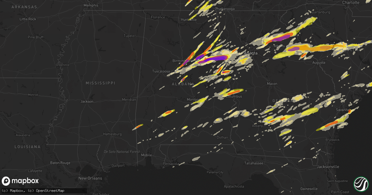
Hail Map in Alabama on April 5, 2017
Get this storm
April 5 map
$229
one time, instant access
Download today. No call, no setup
Keep the $229
Bought the map and want the full workflow? Apply the entire $229 to a subscription within 7 days. None of it is wasted.
Every map, not just this one
This buys you this map. Subscription and you get every map we run, in the markets you choose from a few cities to whole states to nationwide. Plus real-time alerts the moment a storm fires.
Contact data
Name, contact info, occupancy, even credit band for addresses in the footprint. You go from where it hit to who to call.
Become the source they trust
Unlimited branding weather history reports on demand. You already have the documented answer ready for the property owner, and you are the one who showed up with it.
Property data and RoofTrace estimates
Pull up any address you have got, its value and the exact code rules for that jurisdiction, straight from One Click Code. Then RoofTrace estimates the squares, pitch, and roof value, priced the way you price.
Storm reports in Alabama
Alabama
| Date | Description |
|---|---|
| 04/05/20176:48 PM CDT | A local report indicates 1.00 inch wind near ALEXANDRIA |
| 04/05/20176:45 PM CDT | A few outbuilding suffered damaged and some equipment was overturned. |
| 04/05/20176:43 PM CDT | A local report indicates 1.25 inch wind near 2 W RIDGEVILLE |
| 04/05/20176:30 PM CDT | Hail may have been larger. |
| 04/05/20176:26 PM CDT | A local report indicates 2.50 inch wind near LINCOLN |
| 04/05/20176:25 PM CDT | Several vehicles had windows broken out and some structure damage. |
| 04/05/20176:23 PM CDT | A local report indicates 3.00 inch wind near 4 SSW OHATCHEE |
| 04/05/20176:22 PM CDT | A local report indicates 2.50 inch wind near PELL CITY |
| 04/05/20176:20 PM CDT | A local report indicates 2.50 inch wind near PELL CITY |
| 04/05/20176:20 PM CDT | A local report indicates 1.25 inch wind near ASHVILLE |
| 04/05/20176:15 PM CDT | A local report indicates 1.00 inch wind near ODENVILLE |
| 04/05/20176:14 PM CDT | A local report indicates 2.75 inch wind near PELL CITY |
| 04/05/20176:13 PM CDT | Several trees uprooted in around springville. |
| 04/05/20176:13 PM CDT | A local report indicates 2.00 inch wind near 2 W PELL CITY |
| 04/05/20176:10 PM CDT | A local report indicates 1.00 inch wind near 1 ENE MARGARET |
| 04/05/20176:10 PM CDT | A local report indicates 1.75 inch wind near WEDOWEE |
| 04/05/20176:08 PM CDT | Quarter size hail covering the ground. |
| 04/05/20176:07 PM CDT | A local report indicates 1.00 inch wind near 1 ENE ODENVILLE |
| 04/05/20176:05 PM CDT | A local report indicates 1.00 inch wind near ARGO |
| 04/05/20176:04 PM CDT | Several trees blown down around argo. |
| 04/05/20176:00 PM CDT | A local report indicates 1.50 inch wind near 3 E TRUSSVILLE |
| 04/05/20175:57 PM CDT | A local report indicates 1.75 inch wind near 2 SSE IRONDALE |
| 04/05/20175:57 PM CDT | A local report indicates 2.50 inch wind near 1 SSW IRONDALE |
| 04/05/20175:56 PM CDT | A local report indicates 3.00 inch wind near 2 WSW IRONDALE |
| 04/05/20175:55 PM CDT | A local report indicates 2.00 inch wind near 3 SW JEMISON |
| 04/05/20175:55 PM CDT | A local report indicates 2.00 inch wind near 1 NW LEEDS |
| 04/05/20175:52 PM CDT | A local report indicates 1.75 inch wind near CAHABA HEIGHTS |
| 04/05/20175:50 PM CDT | A local report indicates 1.00 inch wind near LEEDS |
| 04/05/20175:50 PM CDT | Colonnade shopping area. |
| 04/05/20175:46 PM CDT | A local report indicates 1.00 inch wind near 1 S VESTAVIA HILLS |
| 04/05/20175:45 PM CDT | A local report indicates 1.00 inch wind near 2 NNW HOOVER VETERANS P |
| 04/05/20175:40 PM CDT | A local report indicates 1.00 inch wind near RIVERCHASE GALLERIA |
| 04/05/20175:38 PM CDT | A local report indicates 1.00 inch wind near 1 NNW RIVERCHASE GALLER |
| 04/05/20175:30 PM CDT | A local report indicates 1.00 inch wind near 1 SSW PATTON CREEK SHOP |
| 04/05/20175:30 PM CDT | A local report indicates 2.50 inch wind near 1 NNW ROANOKE |
| 04/05/20175:28 PM CDT | A local report indicates 1.00 inch wind near 3 SSW BENT BROOK GOLF C |
| 04/05/20175:26 PM CDT | A local report indicates 1.00 inch wind near 4 SSW BENT BROOK GOLF C |
| 04/05/20175:12 PM CDT | A local report indicates 1.00 inch wind near 3 NNE WADLEY |
| 04/05/20174:56 PM CDT | Quarter sized hail was reported. |
| 04/05/20174:56 PM CDT | Quarter size hail on jordan road in huntsville. |
| 04/05/20174:56 PM CDT | Quarter sized hail was reported on jordan road. |
| 04/05/20174:55 PM CDT | Quarter size hail in medical district of huntsville hospital. |
| 04/05/20174:51 PM CDT | Straight line winds caused damage around new site. One barn was damaged and several trees were snapped off. Winds estimated at 70-75 mph. |
| 04/05/20174:45 PM CDT | Quarter size hail hail on cr 9. |
| 04/05/20174:40 PM CDT | Minor tree damage... Damage to a chicken house roof. Tornado caught on video. |
| 04/05/20174:40 PM CDT | Tree downed. |
| 04/05/20174:39 PM CDT | Golfball- to tennis ball-sized hail. |
| 04/05/20174:35 PM CDT | Hail was measured at 2.25 inches. |
| 04/05/20174:30 PM CDT | A local report indicates 1.25 inch wind near 2 NE TENNALA |
| 04/05/20174:28 PM CDT | A local report indicates 1.75 inch wind near 1 NE HEFLIN |
| 04/05/20174:23 PM CDT | A local report indicates 2.00 inch wind near 3 SSW HEFLIN |
| 04/05/20174:23 PM CDT | Golfball- to tennis ball-sized hail. Time corrected |
| 04/05/20174:20 PM CDT | Trees blown down on county line road. |
| 04/05/20174:15 PM CDT | A local report indicates 1.00 inch wind near 1 ESE REAVES |
| 04/05/20174:12 PM CDT | Trees down across the road at stemley road and renfroe road. |
| 04/05/20174:11 PM CDT | A local report indicates 1.75 inch wind near 3 ENE COBB CITY |
| 04/05/20174:11 PM CDT | A local report indicates 1.25 inch wind near 3 SW REAVES |
| 04/05/20174:10 PM CDT | A local report indicates 1.75 inch wind near OXFORD |
| 04/05/20174:05 PM CDT | A local report indicates 1.25 inch wind near OXFORD |
| 04/05/20173:55 PM CDT | Hail was measured at 3.75 inches in diameter. Several vehicles had windows broken out and some structure damage. |
| 04/05/20173:54 PM CDT | Several more reports of baseball-sized hail reported in the munford area. |
| 04/05/20173:54 PM CDT | A local report indicates 2.00 inch wind near MUNFORD |
| 04/05/20173:50 PM CDT | A local report indicates 1.00 inch wind near 7 WNW MORGAN SPRINGS |
| 04/05/20173:50 PM CDT | A local report indicates 1.50 inch wind near OHATCHEE |
| 04/05/20173:42 PM CDT | A local report indicates 1.75 inch wind near 3 N TALLADEGA |
| 04/05/20173:36 PM CDT | A local report indicates 1.75 inch wind near 2 ENE HOWELL'S COVE |
| 04/05/20172:58 PM CDT | A local report indicates 1.75 inch wind near 4 WNW TWIN SPRINGS |
| 04/05/20171:17 PM CDT | Two weekend homes had been heavily damaged from fallen trees. Several other trees down in the area. Possible tornado. |
| 04/05/201712:45 PM CDT | Tree down on house. Estimated 40-50 mph winds. |
| 04/05/201710:53 AM CDT | Many trees and power lines down along state route 95 near holly and calhoun drives in the white oak subdivision. This could possibly be tornado damage and will be inves |
| 04/05/201710:50 AM CDT | Preliminary data from storm survey suggests ef-2 tornado touchdown near the henry/barbour county line before moving into quitman county. Surveys are ongoing along the r |
| 04/05/201710:25 AM CDT | A local report indicates 1.00 inch wind near 2 SSW HOPE HULL |
| 04/05/201710:15 AM CDT | Trees down at boykin avenue and don circle. One power line down. |
| 04/05/20179:49 AM CDT | 10:49 am cdt. Tae surveyed ef1 damage in southern barbour county. |
| 04/05/20179:10 AM CDT | Pictures on social media of ping pong to golf ball size hail in camden |
| 04/05/20178:36 AM CDT | Trees down blocking dickinson road |
| 04/05/20177:41 AM CDT | Tree down blocking westover road near old highway 280. Estimated 40-50 mph winds. |
| 04/05/20177:39 AM CDT | Tree down near the intersection of county road 5 and bishop road in clay county. Estimated 40-50 mph winds. |
| 04/04/201710:07 PM CDT | Trees were blown down in and around smiths station. |
| 04/04/201710:05 PM CDT | A local report indicates 1.75 inch wind near SMITHS STATION |
| 04/04/201710:04 PM CDT | A local report indicates 1.00 inch wind near BLEECKER |
| 04/04/201710:03 PM CDT | A local report indicates 1.00 inch wind near SALEM |
| 04/04/20179:38 PM CDT | A local report indicates 1.00 inch wind near BEAUREGARD |
| 04/04/20179:37 PM CDT | A local report indicates 1.00 inch wind near OPELIKA |
| 04/04/20179:31 PM CDT | A local report indicates 1.00 inch wind near OPELIKA |
| 04/04/20178:42 PM CDT | Several trees blown down. Possible tornado. |
| 04/04/20178:41 PM CDT | Several trees blown down. Possible tornado. |
| 04/04/20178:40 PM CDT | Radar detected tds in northwest chambers county. |
| 04/04/20178:39 PM CDT | Several trees were uprooted along the path. One barn suffered minor damage... One barn suffered major damage and one small fire station had major damage. |
| 04/04/20178:22 PM CDT | A large tree was blown down and blocking the road. |
| 04/04/20177:45 PM CDT | Lots of hail ranging from pea to quarter size around hanover. |
| 04/04/20177:25 PM CDT | Quarter sized hail was reported on cr-89 and fell for about 3 minutes. |
| 04/04/20177:15 PM CDT | Quarter size hail reported in downtown fort payne... Near interstate 59. |
| 04/04/20177:04 PM CDT | A local report indicates 1.00 inch wind near PIEDMONT |
All States Impacted by Hail Map on April 5, 2017
Cities Impacted by Hail Map on April 5, 2017
- Wray, GA
- Ambrose, GA
- Fitzgerald, GA
- Broxton, GA
- Ocilla, GA
- Oak Island, NC
- Harned, KY
- Hardinsburg, KY
- Webster, KY
- Mammoth Cave, KY
- Bee Spring, KY
- Lineville, AL
- Dunmor, KY
- Belton, KY
- Morgantown, KY
- Orlinda, TN
- Rockfield, KY
- Woodburn, KY
- Oakland, KY
- Bowling Green, KY
- Brownsville, KY
- Springfield, TN
- Smiths Grove, KY
- Franklin, KY
- Park City, KY
- Gulf Breeze, FL
- Gordonsville, TN
- Moss, TN
- Watertown, TN
- Whitleyville, TN
- Carthage, TN
- Riddleton, TN
- Tompkinsville, KY
- Hartsville, TN
- Lafayette, TN
- Red Boiling Springs, TN
- Brush Creek, TN
- Lebanon, TN
- Elmwood, TN
- Pleasant Shade, TN
- Dixon Springs, TN
- Atlanta, GA
- Durham, NC
- Georgetown, SC
- Nesmith, SC
- Kingstree, SC
- Andrews, SC
- Hemingway, SC
- Waleska, GA
- Midland City, AL
- Newville, AL
- Lake View, SC
- Fairmont, NC
- Sonora, KY
- Upton, KY
- Dillon, SC
- Latta, SC
- Sellers, SC
- Farmersville, OH
- Centre, AL
- Vandalia, OH
- Stamping Ground, KY
- Georgetown, KY
- Midway, KY
- Sadieville, KY
- Frankfort, KY
- Leesville, SC
- Gaston, SC
- Pelion, SC
- Wagener, SC
- Lexington, SC
- Shelbyville, KY
- Bagdad, KY
- New Salisbury, IN
- Ramsey, IN
- Palmyra, IN
- Depauw, IN
- Winchester, KY
- Clay City, KY
- Jeffersonville, KY
- Adairville, KY
- Clayton, AL
- Clio, AL
- Ariton, AL
- Louisville, AL
- Shaw Afb, SC
- Rembert, SC
- Wedgefield, SC
- Cayce, SC
- Dalzell, SC
- Eastover, SC
- Hopkins, SC
- Columbia, SC
- West Columbia, SC
- Sumter, SC
- Gilbert, SC
- Birmingham, AL
- Leeds, AL
- Scottsville, KY
- Holland, KY
- Westminster, SC
- Seneca, SC
- Jacksonville, AL
- Reidsville, GA
- Uvalda, GA
- Hazlehurst, GA
- Lyons, GA
- Central, SC
- Roundhill, KY
- Cub Run, KY
- Clarkson, KY
- Sweeden, KY
- Anniston, AL
- Munford, AL
- Oxford, AL
- Talladega, AL
- Eastaboga, AL
- Eminence, KY
- Bethlehem, KY
- Lockport, KY
- Pleasureville, KY
- Owenton, KY
- Camden, AL
- Arabi, GA
- Ashburn, GA
- Alvaton, KY
- Midway, GA
- Prospect Hill, NC
- Leasburg, NC
- Pike Road, AL
- Gordon, AL
- Vincent, AL
- Sterrett, AL
- Glenwood, GA
- Soperton, GA
- Adrian, GA
- Dublin, GA
- Rockledge, GA
- East Dublin, GA
- Columbiana, AL
- Chelsea, AL
- Wilsonville, AL
- Greensburg, KY
- Thomson, GA
- Cedar Bluff, AL
- Piedmont, AL
- Gaylesville, AL
- Cordele, GA
- Riceville, TN
- Athens, TN
- Buffalo Valley, TN
- Silver Point, TN
- Bloomington, IN
- Bolivia, NC
- Supply, NC
- Starr, SC
- Canon, GA
- Danielsville, GA
- Pendergrass, GA
- Winder, GA
- Commerce, GA
- Hull, GA
- Dewy Rose, GA
- Talmo, GA
- Dacula, GA
- Gillsville, GA
- Jefferson, GA
- Auburn, GA
- Bowersville, GA
- Carnesville, GA
- Royston, GA
- Braselton, GA
- Buford, GA
- Iva, SC
- Gainesville, GA
- Hartwell, GA
- Lawrenceville, GA
- Hoschton, GA
- Maysville, GA
- Bowman, GA
- Flowery Branch, GA
- Lumpkin, GA
- Georgetown, GA
- Morris, GA
- Payneville, KY
- Brandenburg, KY
- Madison, GA
- Stephens, GA
- Greensboro, GA
- Watkinsville, GA
- Union Point, GA
- Newport, KY
- California, KY
- Cincinnati, OH
- Latonia, KY
- Batavia, OH
- New Richmond, OH
- Alexandria, KY
- Melbourne, KY
- Amelia, OH
- Morning View, KY
- Dayton, OH
- Rhine, GA
- Mount Orab, OH
- Fayetteville, OH
- Sardinia, OH
- Lynchburg, OH
- Roanoke, AL
- Wadley, AL
- Graham, AL
- Daviston, AL
- Alexander City, AL
- Bowdon, GA
- Woodland, AL
- Wedowee, AL
- Lincolnton, GA
- Lithia Springs, GA
- Douglasville, GA
- Austell, GA
- Winston, GA
- Gadsden, AL
- Wellington, AL
- Ohatchee, AL
- Muscadine, AL
- Bremen, GA
- Carrollton, GA
- Delta, AL
- Heflin, AL
- Waco, GA
- Ranburne, AL
- Elberton, GA
- Troy, SC
- Mount Carmel, SC
- McCormick, SC
- Carlton, GA
- Lexington, GA
- Rayle, GA
- Washington, GA
- Tignall, GA
- Sutherlin, VA
- Gibsonville, NC
- Milton, NC
- Pleasant Garden, NC
- Franklinville, NC
- Julian, NC
- Burlington, NC
- Climax, NC
- Liberty, NC
- Greensboro, NC
- Blanch, NC
- Alton, VA
- South Boston, VA
- Whitsett, NC
- Elon, NC
- Randleman, NC
- Yanceyville, NC
- McLeansville, NC
- Asheboro, NC
- Reidsville, NC
- Ringgold, VA
- Lakeland, GA
- Trussville, AL
- Rebecca, GA
- Sycamore, GA
- Rochelle, GA
- Lake Panasoffkee, FL
- Wildwood, FL
- Leitchfield, KY
- Temple, GA
- Villa Rica, GA
- Dallas, GA
- Dozier, AL
- Jemison, AL
- West Blocton, AL
- Vance, AL
- Woodstock, AL
- Bethel, OH
- Decherd, TN
- Ash, NC
- Southport, NC
- Carolina Beach, NC
- Shallotte, NC
- Wilmington, NC
- Sunset Beach, NC
- Longwood, NC
- Winnabow, NC
- Calabash, NC
- Ocean Isle Beach, NC
- Longs, SC
- Little River, SC
- Palmetto, GA
- Ranger, GA
- Fairmount, GA
- Versailles, KY
- Bradfordsville, KY
- Anderson, SC
- Lilburn, GA
- Oakwood, GA
- Alpharetta, GA
- Norcross, GA
- Cumming, GA
- Comer, GA
- Nicholson, GA
- Grayson, GA
- Tucker, GA
- Suwanee, GA
- Snellville, GA
- Defuniak Springs, FL
- Niceville, FL
- Holly Hill, SC
- Harleyville, SC
- Homerville, GA
- Naylor, GA
- Cochran, GA
- Baxter, TN
- Smithville, TN
- Cookeville, TN
- Gainesboro, TN
- Hilham, TN
- Bloomington Springs, TN
- Adams Run, SC
- Jacksonboro, SC
- Green Pond, SC
- Round O, SC
- Hernando, FL
- Dunnellon, FL
- Lexington, KY
- Nicholasville, KY
- Waco, KY
- Mount Sterling, KY
- Lancaster, KY
- Richmond, KY
- Brewton, AL
- Owingsville, KY
- Olympia, KY
- Salt Lick, KY
- Jesup, GA
- Richmond Hill, GA
- Riceboro, GA
- Savannah, GA
- Townsend, GA
- Ludowici, GA
- Fayetteville, TN
- Petersburg, TN
- Wartrace, TN
- Normandy, TN
- Manchester, TN
- Shelbyville, TN
- Tullahoma, TN
- Garfield, KY
- Irvington, KY
- McDaniels, KY
- Falls Of Rough, KY
- Westview, KY
- Eaton, OH
- Germantown, OH
- Bath, IN
- Hamilton, OH
- Middletown, OH
- West Alexandria, OH
- West College Corner, IN
- Miamisburg, OH
- Oxford, OH
- New Lebanon, OH
- Camden, OH
- Brookville, IN
- Tipp City, OH
- Fairborn, OH
- College Corner, OH
- Brookville, OH
- Somerville, OH
- Branchville, SC
- Cope, SC
- Bradyville, TN
- Woodbury, TN
- Inman, SC
- Lyman, SC
- Wellford, SC
- Alapaha, GA
- Willacoochee, GA
- Appling, GA
- Springville, AL
- Odenville, AL
- Frenchburg, KY
- Lithia, FL
- Conway, SC
- Palestine, WV
- Elizabeth, WV
- Bessemer, AL
- Bell Buckle, TN
- Murfreesboro, TN
- Christiana, TN
- Mulberry, FL
- Boston, KY
- Bardstown, KY
- Morehead, KY
- Wallingford, KY
- Liberty, KY
- Salem, IN
- Fredericksburg, IN
- Pekin, IN
- Corydon, IN
- Monetta, SC
- Ward, SC
- Modoc, SC
- Batesburg, SC
- Ridge Spring, SC
- Saluda, SC
- Edgefield, SC
- Johnston, SC
- Plum Branch, SC
- Williamsburg, OH
- Dexter, GA
- Cadwell, GA
- Smithville, GA
- Leesburg, GA
- Lincoln, AL
- Riverside, AL
- Pell City, AL
- Ragland, AL
- Alexandria, AL
- Saint Petersburg, FL
- Winchester, TN
- Estillfork, AL
- Cowan, TN
- Belvidere, TN
- Sewanee, TN
- Means, KY
- Bamberg, SC
- Olar, SC
- Ehrhardt, SC
- Dry Ridge, KY
- Crittenden, KY
- Marianna, FL
- Cottondale, FL
- Coy, AL
- Pine Hill, AL
- Fairfield, KY
- Elizabethtown, KY
- Lebanon Junction, KY
- Bloomfield, KY
- Taylorsville, KY
- Coxs Creek, KY
- Gurley, AL
- Huntsville, AL
- Rochester, KY
- Lewisburg, KY
- Leesburg, OH
- Greenfield, OH
- Decatur, GA
- Jakin, GA
- Moody, AL
- Summersville, KY
- Horse Branch, KY
- Cromwell, KY
- Lancaster, SC
- Pine Apple, AL
- Roswell, GA
- Weston, GA
- Dawson, GA
- Preston, GA
- Cuthbert, GA
- Richland, GA
- Parrott, GA
- Butler, KY
- Moscow, OH
- Hillsboro, OH
- Roopville, GA
- Georgetown, IN
- Lanesville, IN
- Senoia, GA
- Brooks, GA
- Peachtree City, GA
- Hampton, GA
- Fayetteville, GA
- Griffin, GA
- Beverly Hills, FL
- Brooksville, FL
- Lecanto, FL
- Inverness, FL
- Homosassa, FL
- Crystal River, FL
- Walterboro, SC
- Easley, SC
- Charleston, SC
- North Charleston, SC
- Opelika, AL
- Auburn, AL
- Pendleton, SC
- Galatia, IL
- Macedonia, IL
- Elba, AL
- Le Roy, WV
- Sandyville, WV
- Lodge, SC
- Sharpsburg, GA
- Newnan, GA
- Union City, GA
- Riverdale, GA
- Fairburn, GA
- Whitesburg, GA
- Tyrone, GA
- Rockford, AL
- Bishopville, SC
- Elliott, SC
- Lynchburg, SC
- Mayesville, SC
- Ramer, AL
- Montgomery, AL
- Letohatchee, AL
- Hope Hull, AL
- Franklin, GA
- McLeansboro, IL
- Milltown, IN
- Leavenworth, IN
- Collinsville, AL
- Fort Payne, AL
- Claxton, GA
- Lumber City, GA
- Collins, GA
- Baxley, GA
- Valley Head, AL
- Cataula, GA
- Waverly Hall, GA
- Ellerslie, GA
- Midland, GA
- Salem, AL
- Smiths Station, AL
- Phenix City, AL
- Columbus, GA
- Fortson, GA
- Johns Island, SC
- Hollywood, SC
- Mount Pleasant, SC
- Ravenel, SC
- Brooklet, GA
- Pembroke, GA
- Simpsonville, SC
- Lebanon, KY
- Gravel Switch, KY
- Campbellsville, KY
- Pineville, SC
- Saint Stephen, SC
- Rineyville, KY
- Shepherdsville, KY
- Big Clifty, KY
- Eastview, KY
- Cecilia, KY
- Glendale, KY
- Lafayette, AL
- Camp Hill, AL
- Ashland, AL
- Millerville, AL
- Goodwater, AL
- Grantville, GA
- Moreland, GA
- Magnolia, KY
- Bonnieville, KY
- Munfordville, KY
- Mount Sherman, KY
- Cross Plains, TN
- Cottontown, TN
- White House, TN
- McKenzie, AL
- Dadeville, AL
- Jacksons Gap, AL
- Lagrange, GA
- Five Points, AL
- Lanett, AL
- Sylvester, GA
- Pulaski, GA
- Metter, GA
- Springfield, GA
- Guyton, GA
- Burkesville, KY
- Albany, KY
- Buchanan, GA
- Tallapoosa, GA
- Cropwell, AL
- Harpersville, AL
- Fruithurst, AL
- Childersburg, AL
- Alpine, AL
- Tybee Island, GA
- Glasgow, KY
- Whitwell, TN
- Millry, AL
- State Line, MS
- Fountain Inn, SC
- Mount Washington, KY
- Cheshire, OH
- Apple Grove, WV
- Clemson, SC
- Townville, SC
- Steele, AL
- Helena, AL
- Attalla, AL
- Ashville, AL
- Perry, FL
- Varnville, SC
- Greenville, IN
- Memphis, IN
- Borden, IN
- Floyds Knobs, IN
- Henryville, IN
- Troy, NC
- New London, NC
- Badin, NC
- Albemarle, NC
- Shellman, GA
- Eufaula, AL
- Plains, GA
- Americus, GA
- Folkston, GA
- Apollo Beach, FL
- Ruskin, FL
- Abbeville, SC
- Greenwood, SC
- Glencoe, KY
- Jonesville, KY
- De Mossville, KY
- Falmouth, KY
- Corinth, KY
- Williamstown, KY
- Simpsonville, KY
- Powder Springs, GA
- Hiram, GA
- Bowling Green, FL
- Bartow, FL
- Homeland, FL
- Bradley, FL
- Mentone, AL
- Brundidge, AL
- Troy, AL
- Glenwood, AL
- Chester, GA
- Hawkinsville, GA
- Vidalia, GA
- Mount Vernon, GA
- Ailey, GA
- Tarrytown, GA
- Greensburg, IN
- Warwick, GA
- Abbeville, GA
- Horse Cave, KY
- Cave City, KY
- Hardyville, KY
- Elk Horn, KY
- Center, KY
- Springfield, OH
- South Vienna, OH
- Lyerly, GA
- Montevallo, AL
- Pelham, AL
- Alabaster, AL
- Brierfield, AL
- Poulan, GA
- Jacksonville, GA
- Milan, GA
- Oakfield, GA
- Swansea, SC
- Olive Hill, KY
- Bradley, SC
- Calhoun, GA
- Greensboro, AL
- Emerson, KY
- Grayson, KY
- Hillsboro, KY
- Stanton, KY
- Clearfield, KY
- Vanceburg, KY
- Hope, KY
- Williamston, SC
- Georgiana, AL
- Evergreen, AL
- Cobbtown, GA
- Kure Beach, NC
- North Myrtle Beach, SC
- Monroe, GA
- Loganville, GA
- Caneyville, KY
- Fordsville, KY
- Olaton, KY
- Guston, KY
- Beaver Dam, KY
- Morrison, TN
- Timmonsville, SC
- Florence, SC
- Darlington, SC
- Shorter, AL
- Rentz, GA
- Swainsboro, GA
- Pedro, OH
- North, SC
- Orangeburg, SC
- Saint Matthews, SC
- Oakboro, NC
- Norwood, NC
- Horton, AL
- Gainestown, AL
- Jackson, AL
- Talbotton, GA
- Enterprise, AL
- Talking Rock, GA
- Old Town, FL
- Sumner, GA
- Ty Ty, GA
- Tifton, GA
- Hodges, SC
- Dowelltown, TN
- Valley, AL
- Cedartown, GA
- Rockmart, GA
- Athens, GA
- Winterville, GA
- Bishop, GA
- Fairfax, SC
- Brunson, SC
- Ulmer, SC
- Allons, TN
- Livingston, TN
- Byrdstown, TN
- Celina, TN
- Hardeeville, SC
- Rincon, GA
- Granite Falls, NC
- Connelly Springs, NC
- Hickory, NC
- Merritt Island, FL
- Melbourne, FL
- Cocoa Beach, FL
- Cape Canaveral, FL
- Rockledge, FL
- Chattanooga, TN
- Douglas, GA
- Lenox, GA
- Nashville, GA
- Marietta, GA
- Grove Hill, AL
- Nashville, IN
- Maplesville, AL
- Register, GA
- McRae Helena, GA
- Pitts, GA
- Statesboro, GA
- Glennville, GA
- Clyo, GA
- Denton, GA
- Ellabell, GA
- Tillman, SC
- Garnett, SC
- Greenbrier, TN
- Knifley, KY
- Knob Lick, KY
- Gradyville, KY
- Mannsville, KY
- Edmonton, KY
- Dunnville, KY
- Columbia, KY
- Portland, TN
- Frisco City, AL
- Uriah, AL
- Cave Spring, GA
- New Market, AL
- Stevenson, AL
- Sherwood, TN
- Tracy City, TN
- Scottsboro, AL
- Princeton, AL
- South Pittsburg, TN
- Signal Mountain, TN
- Sequatchie, TN
- Dunlap, TN
- Fackler, AL
- Brownsboro, AL
- Wadmalaw Island, SC
- Edisto Island, SC
- Jasper, TN
- Pisgah, AL
- Flat Rock, AL
- Higdon, AL
- Ider, AL
- Henagar, AL
- Graysville, TN
- Statham, GA
- Trenton, GA
- Wildwood, GA
- Yemassee, SC
- Lumberton, NC
- Aiken, SC
- Lamar, SC
- Gadsden, SC
- Pelzer, SC
- Belton, SC
- Piedmont, SC
- Greenville, SC
- Mcminnville, TN
- Lawrenceburg, KY
- Waddy, KY
- Raywick, KY
- Blenheim, SC
- Middleburg, KY
- Repton, AL
- Calhoun Falls, SC
- Hogansville, GA
- Greenville, GA
- Newberry, IN
- Bloomfield, IN
- Live Oak, FL
- Lee, FL
- Valdosta, GA
- Rhodelia, KY
- Union Star, KY
- Pomaria, SC
- Westville, FL
- Ponce De Leon, FL
- Hillsboro, TN
- Little River, AL
- McIntosh, AL
- Kellyton, AL
- Geff, IL
- Notasulga, AL
- Jetson, KY
- Awendaw, SC
- Menlo, GA
- Highland Home, AL
- Tallassee, AL
- Mount Hermon, KY
- Cragford, AL
- Wetumpka, AL
- Aragon, GA
- Monteagle, TN
- Pelham, TN
- Navarre, FL
- Sellersburg, IN
- Horseshoe Beach, FL
- Early Branch, SC
- Ozark, AL
- Daleville, AL
- Fort Rucker, AL
- Newton, AL
- Fountain Run, KY
- Summer Shade, KY
- Adolphus, KY
- Westmoreland, TN
- Etoile, KY
- Marbury, AL
- Citronelle, AL
- Lower Peach Tree, AL
- Omaha, GA
- Midway, AL
- Hayneville, AL
- Lowndesboro, AL
- Russell Springs, KY
- Stockton, GA
- Du Pont, GA
- Buckhead, GA
- Newberry, SC
- Pinewood, SC
- Leslie, GA
- Gray Court, SC
- Barboursville, WV
- Milton, WV
- Ona, WV
- Colquitt, GA
- Altamont, TN
- Eclectic, AL
- Unadilla, GA
- Vienna, GA
- Buffalo, KY
- Slocomb, AL
- Thompsonville, IL
- Bluffton, GA
- Fort Gaines, GA
- Coleman, GA
- Sylvania, GA
- Saint Augustine, FL
- Rainbow City, AL
- McCalla, AL
- Rising Fawn, GA
- Portal, GA
- Tuskegee Institute, AL
- Union Springs, AL
- Tuskegee, AL
- Hurtsboro, AL
- Box Springs, GA
- Hatchechubbee, AL
- Twin City, GA
- Fraziers Bottom, WV
- Ashton, WV
- Leon, WV
- Southside, WV
- Evans, WV
- Cottageville, WV
- Gallipolis Ferry, WV
- Ripley, WV
- Weaver, AL
- Pittsboro, NC
- Chapel Hill, NC
- Eastman, GA
- Mauldin, SC
- Estill, SC
- Lake City, FL
- Rio Grande, OH
- Thurman, OH
- Patriot, OH
- Oak Hill, OH
- Gallipolis, OH
- Vinton, OH
- Bidwell, OH
- Meridianville, AL
- Goshen, OH
- Hamersville, OH
- Finchville, KY
- Louisville, KY
- Fisherville, KY
- Auburn, KY
- Russellville, KY
- Forest Park, GA
- Glens Fork, KY
- Whitesville, KY
- Newton, GA
- Albany, GA
- Springerton, IL
- Leesburg, AL
- Jonesboro, GA
- Red Level, AL
- Mount Eden, KY
- New Haven, KY
- West Point, KY
- Enigma, GA
- Paris, KY
- Commiskey, IN
- North Vernon, IN
- Cynthiana, KY
- Beersheba Springs, TN
- Crawford, GA
- Rutledge, GA
- Crawfordville, GA
- Clarks Hill, SC
- Norwood, GA
- Fort Deposit, AL
- Cecil, AL
- Graceville, FL
- Chipley, FL
- Baconton, GA
- Camilla, GA
- Bluffton, SC
- Creston, WV
- Covington, GA
- Lucedale, MS
- Lascassas, TN
- Auburntown, TN
- Milton, TN
- Duncanville, AL
- Vandiver, AL
- Calera, AL
- Mableton, GA
- Morrow, GA
- Cottondale, AL
- Smyrna, GA
- New Zion, SC
- Ridgeland, SC
- Greer, SC
- Peachtree Corners, GA
- Stone Mountain, GA
- Homer, GA
- Woodruff, SC
- Duluth, GA
- Myrtle Beach, SC
- Mcdonough, GA
- Verbena, AL
- Equality, AL
- Lithonia, GA
- Middleport, OH
- Bonifay, FL
- Alamo, GA
- Cross, SC
- Bell, FL
- Sparta, TN
- Union Mills, NC
- Bostic, NC
- Rutherfordton, NC
- Doerun, GA
- Olanta, SC
- Beechgrove, TN
- Readyville, TN
- Pearson, GA
- Sylacauga, AL
- Denton, NC
- Baldwin, GA
- Lula, GA
- Toccoa, GA
- Alto, GA
- Hardinsburg, IN
- Stem, NC
- Creedmoor, NC
- Butner, NC
- Saint Helena Island, SC
- Lawley, AL
- Randolph, AL
- Oxford, NC
- Foster, KY
- Ray City, GA
- Chauncey, GA
- Albertville, AL
- Guntersville, AL
- Elgin, SC
- Lugoff, SC
- Springfield, KY
- Yulee, FL
- Russell, KY
- Ashland, KY
- Argillite, KY
- Greenup, KY
- Worthington, KY
- Ironton, OH
- Flatwoods, KY
- Lynchburg, TN
- Scottown, OH
- Crown City, OH
- Beaufort, SC
- Hilton Head Island, SC
- Elora, TN
- Hazel Green, AL
- Castleberry, AL
- Moody Afb, GA
- Good Hope, GA
- Chickamauga, GA
- Rossville, GA
- Martin, GA
- Fair Play, SC
- Lavonia, GA
- Saint George, GA
- Bridgeport, AL
- Bethlehem, GA
- Hortense, GA
- Westport, IN
- Paint Lick, KY
- Spencer, TN
- Taylors, SC
- Trion, GA
- Summerville, GA
- Clanton, AL
- White Springs, FL
- Monroeville, AL
- Pelham, GA
- Caryville, FL
- Salley, SC
- Eighty Eight, KY
- Hilliard, FL
- Oxford, GA
- Conyers, GA
- Hodgenville, KY
- Brantley, AL
- Rydal, GA
- White, GA
- Huntland, TN
- Troy, OH
- Rainsville, AL
- Sylvania, AL
- Bryant, AL
- Reedy, WV
- Fort Meade, FL
- Wimauma, FL
- Riverview, FL
- Vine Grove, KY
- Waterloo, OH
- Sun City Center, FL
- De Soto, GA
- Pineview, GA
- Pinehurst, GA
- Cobb, GA
- Rock Island, TN
- Smithfield, KY
- Mount Vernon, AL
- Battletown, KY
- Rome, IN
- Hawesville, KY
- Cannelton, IN
- Mauckport, IN
- Central, IN
- Rocky Hill, KY
- White Mills, KY
- Cisne, IL
- Fairfield, IL
- Sims, IL
- Wayne City, IL
- Burnt Prairie, IL
- Barnhill, IL
- Enfield, IL
- Broughton, IL
- Dale, IL
- Mill Shoals, IL
- West Salem, IL
- Sumner, IL
- Claremont, IL
- Olney, IL
- Parkersburg, IL
- Calhoun, IL
- Bridgeport, IL
- Mount Erie, IL
- Alexandria, TN
- Flintville, TN
- Alpha, KY
- Gamaliel, KY
- Smoaks, SC
- Lynn, IN
- Minter, AL
- New Carlisle, OH
- Medway, OH
- New Vienna, OH
- Morganton, NC
- Valdese, NC
- Drexel, NC
- Sophia, NC
- Ruffin, NC
- Keeling, VA
- Apex, NC
- Screven, GA
- Colbert, GA
- Honea Path, SC


