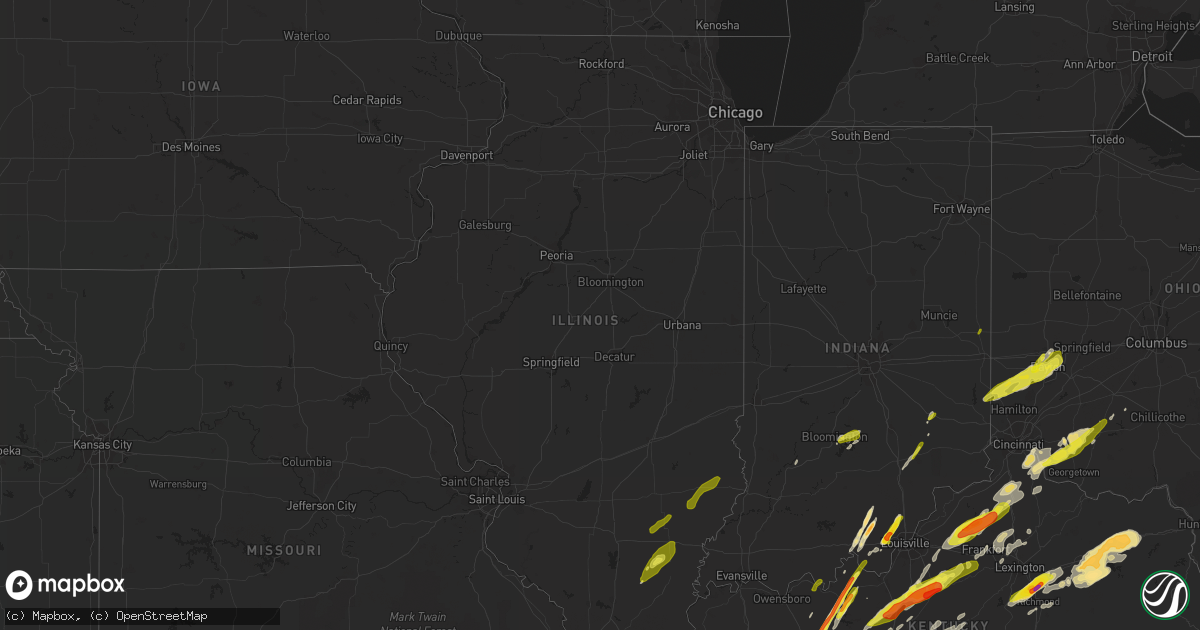
Hail Map in Illinois on April 5, 2017
Get this storm
April 5 map
$229
one time, instant access
Download today. No call, no setup
Keep the $229
Bought the map and want the full workflow? Apply the entire $229 to a subscription within 7 days. None of it is wasted.
Every map, not just this one
This buys you this map. Subscription and you get every map we run, in the markets you choose from a few cities to whole states to nationwide. Plus real-time alerts the moment a storm fires.
Contact data
Name, contact info, occupancy, even credit band for addresses in the footprint. You go from where it hit to who to call.
Become the source they trust
Unlimited branding weather history reports on demand. You already have the documented answer ready for the property owner, and you are the one who showed up with it.
Property data and RoofTrace estimates
Pull up any address you have got, its value and the exact code rules for that jurisdiction, straight from One Click Code. Then RoofTrace estimates the squares, pitch, and roof value, priced the way you price.
Storm reports in Illinois
Illinois
| Date | Description |
|---|---|
| 04/05/20174:09 PM CDT | Reported 1 mile north of route 50. |
| 04/05/20173:49 PM CDT | Pea to quarter size hail at 500 north and route 130...south of olney and west of calhoun. |
| 04/05/20173:34 PM CDT | Another enfield report. Possible tornado. Witnesses saw funnel. Large trees 4 feet in diameter uprooted. Tree tops twisted and broke apart. Some car ports were lifted a |
| 04/05/20173:33 PM CDT | Peak winds 90 mph. Dozens of trees and large limbs down primarily in the city limits. Some minor roof damage occurred at several houses... An apartment building... And |
| 04/05/20173:22 PM CDT | Viewer submitted picture slightly larger than quarter sized. |
| 04/05/20172:10 PM CDT | A brief ef1 tornado touched down damaging 2 residences and a few trees. Details can be found in public information statement. |
| 04/05/20172:08 PM CDT | Significant roof damage to home and tree slammed through garage. Damage oriented northwest to southeast. Occurred on cameron dr near dogwood rd. |
All States Impacted by Hail Map on April 5, 2017
Cities Impacted by Hail Map on April 5, 2017
- Wray, GA
- Ambrose, GA
- Fitzgerald, GA
- Broxton, GA
- Ocilla, GA
- Oak Island, NC
- Harned, KY
- Hardinsburg, KY
- Webster, KY
- Mammoth Cave, KY
- Bee Spring, KY
- Lineville, AL
- Dunmor, KY
- Belton, KY
- Morgantown, KY
- Orlinda, TN
- Rockfield, KY
- Woodburn, KY
- Oakland, KY
- Bowling Green, KY
- Brownsville, KY
- Springfield, TN
- Smiths Grove, KY
- Franklin, KY
- Park City, KY
- Gulf Breeze, FL
- Gordonsville, TN
- Moss, TN
- Watertown, TN
- Whitleyville, TN
- Carthage, TN
- Riddleton, TN
- Tompkinsville, KY
- Hartsville, TN
- Lafayette, TN
- Red Boiling Springs, TN
- Brush Creek, TN
- Lebanon, TN
- Elmwood, TN
- Pleasant Shade, TN
- Dixon Springs, TN
- Atlanta, GA
- Durham, NC
- Georgetown, SC
- Nesmith, SC
- Kingstree, SC
- Andrews, SC
- Hemingway, SC
- Waleska, GA
- Midland City, AL
- Newville, AL
- Lake View, SC
- Fairmont, NC
- Sonora, KY
- Upton, KY
- Dillon, SC
- Latta, SC
- Sellers, SC
- Farmersville, OH
- Centre, AL
- Vandalia, OH
- Stamping Ground, KY
- Georgetown, KY
- Midway, KY
- Sadieville, KY
- Frankfort, KY
- Leesville, SC
- Gaston, SC
- Pelion, SC
- Wagener, SC
- Lexington, SC
- Shelbyville, KY
- Bagdad, KY
- New Salisbury, IN
- Ramsey, IN
- Palmyra, IN
- Depauw, IN
- Winchester, KY
- Clay City, KY
- Jeffersonville, KY
- Adairville, KY
- Clayton, AL
- Clio, AL
- Ariton, AL
- Louisville, AL
- Shaw Afb, SC
- Rembert, SC
- Wedgefield, SC
- Cayce, SC
- Dalzell, SC
- Eastover, SC
- Hopkins, SC
- Columbia, SC
- West Columbia, SC
- Sumter, SC
- Gilbert, SC
- Birmingham, AL
- Leeds, AL
- Scottsville, KY
- Holland, KY
- Westminster, SC
- Seneca, SC
- Jacksonville, AL
- Reidsville, GA
- Uvalda, GA
- Hazlehurst, GA
- Lyons, GA
- Central, SC
- Roundhill, KY
- Cub Run, KY
- Clarkson, KY
- Sweeden, KY
- Anniston, AL
- Munford, AL
- Oxford, AL
- Talladega, AL
- Eastaboga, AL
- Eminence, KY
- Bethlehem, KY
- Lockport, KY
- Pleasureville, KY
- Owenton, KY
- Camden, AL
- Arabi, GA
- Ashburn, GA
- Alvaton, KY
- Midway, GA
- Prospect Hill, NC
- Leasburg, NC
- Pike Road, AL
- Gordon, AL
- Vincent, AL
- Sterrett, AL
- Glenwood, GA
- Soperton, GA
- Adrian, GA
- Dublin, GA
- Rockledge, GA
- East Dublin, GA
- Columbiana, AL
- Chelsea, AL
- Wilsonville, AL
- Greensburg, KY
- Thomson, GA
- Cedar Bluff, AL
- Piedmont, AL
- Gaylesville, AL
- Cordele, GA
- Riceville, TN
- Athens, TN
- Buffalo Valley, TN
- Silver Point, TN
- Bloomington, IN
- Bolivia, NC
- Supply, NC
- Starr, SC
- Canon, GA
- Danielsville, GA
- Pendergrass, GA
- Winder, GA
- Commerce, GA
- Hull, GA
- Dewy Rose, GA
- Talmo, GA
- Dacula, GA
- Gillsville, GA
- Jefferson, GA
- Auburn, GA
- Bowersville, GA
- Carnesville, GA
- Royston, GA
- Braselton, GA
- Buford, GA
- Iva, SC
- Gainesville, GA
- Hartwell, GA
- Lawrenceville, GA
- Hoschton, GA
- Maysville, GA
- Bowman, GA
- Flowery Branch, GA
- Lumpkin, GA
- Georgetown, GA
- Morris, GA
- Payneville, KY
- Brandenburg, KY
- Madison, GA
- Stephens, GA
- Greensboro, GA
- Watkinsville, GA
- Union Point, GA
- Newport, KY
- California, KY
- Cincinnati, OH
- Latonia, KY
- Batavia, OH
- New Richmond, OH
- Alexandria, KY
- Melbourne, KY
- Amelia, OH
- Morning View, KY
- Dayton, OH
- Rhine, GA
- Mount Orab, OH
- Fayetteville, OH
- Sardinia, OH
- Lynchburg, OH
- Roanoke, AL
- Wadley, AL
- Graham, AL
- Daviston, AL
- Alexander City, AL
- Bowdon, GA
- Woodland, AL
- Wedowee, AL
- Lincolnton, GA
- Lithia Springs, GA
- Douglasville, GA
- Austell, GA
- Winston, GA
- Gadsden, AL
- Wellington, AL
- Ohatchee, AL
- Muscadine, AL
- Bremen, GA
- Carrollton, GA
- Delta, AL
- Heflin, AL
- Waco, GA
- Ranburne, AL
- Elberton, GA
- Troy, SC
- Mount Carmel, SC
- McCormick, SC
- Carlton, GA
- Lexington, GA
- Rayle, GA
- Washington, GA
- Tignall, GA
- Sutherlin, VA
- Gibsonville, NC
- Milton, NC
- Pleasant Garden, NC
- Franklinville, NC
- Julian, NC
- Burlington, NC
- Climax, NC
- Liberty, NC
- Greensboro, NC
- Blanch, NC
- Alton, VA
- South Boston, VA
- Whitsett, NC
- Elon, NC
- Randleman, NC
- Yanceyville, NC
- McLeansville, NC
- Asheboro, NC
- Reidsville, NC
- Ringgold, VA
- Lakeland, GA
- Trussville, AL
- Rebecca, GA
- Sycamore, GA
- Rochelle, GA
- Lake Panasoffkee, FL
- Wildwood, FL
- Leitchfield, KY
- Temple, GA
- Villa Rica, GA
- Dallas, GA
- Dozier, AL
- Jemison, AL
- West Blocton, AL
- Vance, AL
- Woodstock, AL
- Bethel, OH
- Decherd, TN
- Ash, NC
- Southport, NC
- Carolina Beach, NC
- Shallotte, NC
- Wilmington, NC
- Sunset Beach, NC
- Longwood, NC
- Winnabow, NC
- Calabash, NC
- Ocean Isle Beach, NC
- Longs, SC
- Little River, SC
- Palmetto, GA
- Ranger, GA
- Fairmount, GA
- Versailles, KY
- Bradfordsville, KY
- Anderson, SC
- Lilburn, GA
- Oakwood, GA
- Alpharetta, GA
- Norcross, GA
- Cumming, GA
- Comer, GA
- Nicholson, GA
- Grayson, GA
- Tucker, GA
- Suwanee, GA
- Snellville, GA
- Defuniak Springs, FL
- Niceville, FL
- Holly Hill, SC
- Harleyville, SC
- Homerville, GA
- Naylor, GA
- Cochran, GA
- Baxter, TN
- Smithville, TN
- Cookeville, TN
- Gainesboro, TN
- Hilham, TN
- Bloomington Springs, TN
- Adams Run, SC
- Jacksonboro, SC
- Green Pond, SC
- Round O, SC
- Hernando, FL
- Dunnellon, FL
- Lexington, KY
- Nicholasville, KY
- Waco, KY
- Mount Sterling, KY
- Lancaster, KY
- Richmond, KY
- Brewton, AL
- Owingsville, KY
- Olympia, KY
- Salt Lick, KY
- Jesup, GA
- Richmond Hill, GA
- Riceboro, GA
- Savannah, GA
- Townsend, GA
- Ludowici, GA
- Fayetteville, TN
- Petersburg, TN
- Wartrace, TN
- Normandy, TN
- Manchester, TN
- Shelbyville, TN
- Tullahoma, TN
- Garfield, KY
- Irvington, KY
- McDaniels, KY
- Falls Of Rough, KY
- Westview, KY
- Eaton, OH
- Germantown, OH
- Bath, IN
- Hamilton, OH
- Middletown, OH
- West Alexandria, OH
- West College Corner, IN
- Miamisburg, OH
- Oxford, OH
- New Lebanon, OH
- Camden, OH
- Brookville, IN
- Tipp City, OH
- Fairborn, OH
- College Corner, OH
- Brookville, OH
- Somerville, OH
- Branchville, SC
- Cope, SC
- Bradyville, TN
- Woodbury, TN
- Inman, SC
- Lyman, SC
- Wellford, SC
- Alapaha, GA
- Willacoochee, GA
- Appling, GA
- Springville, AL
- Odenville, AL
- Frenchburg, KY
- Lithia, FL
- Conway, SC
- Palestine, WV
- Elizabeth, WV
- Bessemer, AL
- Bell Buckle, TN
- Murfreesboro, TN
- Christiana, TN
- Mulberry, FL
- Boston, KY
- Bardstown, KY
- Morehead, KY
- Wallingford, KY
- Liberty, KY
- Salem, IN
- Fredericksburg, IN
- Pekin, IN
- Corydon, IN
- Monetta, SC
- Ward, SC
- Modoc, SC
- Batesburg, SC
- Ridge Spring, SC
- Saluda, SC
- Edgefield, SC
- Johnston, SC
- Plum Branch, SC
- Williamsburg, OH
- Dexter, GA
- Cadwell, GA
- Smithville, GA
- Leesburg, GA
- Lincoln, AL
- Riverside, AL
- Pell City, AL
- Ragland, AL
- Alexandria, AL
- Saint Petersburg, FL
- Winchester, TN
- Estillfork, AL
- Cowan, TN
- Belvidere, TN
- Sewanee, TN
- Means, KY
- Bamberg, SC
- Olar, SC
- Ehrhardt, SC
- Dry Ridge, KY
- Crittenden, KY
- Marianna, FL
- Cottondale, FL
- Coy, AL
- Pine Hill, AL
- Fairfield, KY
- Elizabethtown, KY
- Lebanon Junction, KY
- Bloomfield, KY
- Taylorsville, KY
- Coxs Creek, KY
- Gurley, AL
- Huntsville, AL
- Rochester, KY
- Lewisburg, KY
- Leesburg, OH
- Greenfield, OH
- Decatur, GA
- Jakin, GA
- Moody, AL
- Summersville, KY
- Horse Branch, KY
- Cromwell, KY
- Lancaster, SC
- Pine Apple, AL
- Roswell, GA
- Weston, GA
- Dawson, GA
- Preston, GA
- Cuthbert, GA
- Richland, GA
- Parrott, GA
- Butler, KY
- Moscow, OH
- Hillsboro, OH
- Roopville, GA
- Georgetown, IN
- Lanesville, IN
- Senoia, GA
- Brooks, GA
- Peachtree City, GA
- Hampton, GA
- Fayetteville, GA
- Griffin, GA
- Beverly Hills, FL
- Brooksville, FL
- Lecanto, FL
- Inverness, FL
- Homosassa, FL
- Crystal River, FL
- Walterboro, SC
- Easley, SC
- Charleston, SC
- North Charleston, SC
- Opelika, AL
- Auburn, AL
- Pendleton, SC
- Galatia, IL
- Macedonia, IL
- Elba, AL
- Le Roy, WV
- Sandyville, WV
- Lodge, SC
- Sharpsburg, GA
- Newnan, GA
- Union City, GA
- Riverdale, GA
- Fairburn, GA
- Whitesburg, GA
- Tyrone, GA
- Rockford, AL
- Bishopville, SC
- Elliott, SC
- Lynchburg, SC
- Mayesville, SC
- Ramer, AL
- Montgomery, AL
- Letohatchee, AL
- Hope Hull, AL
- Franklin, GA
- McLeansboro, IL
- Milltown, IN
- Leavenworth, IN
- Collinsville, AL
- Fort Payne, AL
- Claxton, GA
- Lumber City, GA
- Collins, GA
- Baxley, GA
- Valley Head, AL
- Cataula, GA
- Waverly Hall, GA
- Ellerslie, GA
- Midland, GA
- Salem, AL
- Smiths Station, AL
- Phenix City, AL
- Columbus, GA
- Fortson, GA
- Johns Island, SC
- Hollywood, SC
- Mount Pleasant, SC
- Ravenel, SC
- Brooklet, GA
- Pembroke, GA
- Simpsonville, SC
- Lebanon, KY
- Gravel Switch, KY
- Campbellsville, KY
- Pineville, SC
- Saint Stephen, SC
- Rineyville, KY
- Shepherdsville, KY
- Big Clifty, KY
- Eastview, KY
- Cecilia, KY
- Glendale, KY
- Lafayette, AL
- Camp Hill, AL
- Ashland, AL
- Millerville, AL
- Goodwater, AL
- Grantville, GA
- Moreland, GA
- Magnolia, KY
- Bonnieville, KY
- Munfordville, KY
- Mount Sherman, KY
- Cross Plains, TN
- Cottontown, TN
- White House, TN
- McKenzie, AL
- Dadeville, AL
- Jacksons Gap, AL
- Lagrange, GA
- Five Points, AL
- Lanett, AL
- Sylvester, GA
- Pulaski, GA
- Metter, GA
- Springfield, GA
- Guyton, GA
- Burkesville, KY
- Albany, KY
- Buchanan, GA
- Tallapoosa, GA
- Cropwell, AL
- Harpersville, AL
- Fruithurst, AL
- Childersburg, AL
- Alpine, AL
- Tybee Island, GA
- Glasgow, KY
- Whitwell, TN
- Millry, AL
- State Line, MS
- Fountain Inn, SC
- Mount Washington, KY
- Cheshire, OH
- Apple Grove, WV
- Clemson, SC
- Townville, SC
- Steele, AL
- Helena, AL
- Attalla, AL
- Ashville, AL
- Perry, FL
- Varnville, SC
- Greenville, IN
- Memphis, IN
- Borden, IN
- Floyds Knobs, IN
- Henryville, IN
- Troy, NC
- New London, NC
- Badin, NC
- Albemarle, NC
- Shellman, GA
- Eufaula, AL
- Plains, GA
- Americus, GA
- Folkston, GA
- Apollo Beach, FL
- Ruskin, FL
- Abbeville, SC
- Greenwood, SC
- Glencoe, KY
- Jonesville, KY
- De Mossville, KY
- Falmouth, KY
- Corinth, KY
- Williamstown, KY
- Simpsonville, KY
- Powder Springs, GA
- Hiram, GA
- Bowling Green, FL
- Bartow, FL
- Homeland, FL
- Bradley, FL
- Mentone, AL
- Brundidge, AL
- Troy, AL
- Glenwood, AL
- Chester, GA
- Hawkinsville, GA
- Vidalia, GA
- Mount Vernon, GA
- Ailey, GA
- Tarrytown, GA
- Greensburg, IN
- Warwick, GA
- Abbeville, GA
- Horse Cave, KY
- Cave City, KY
- Hardyville, KY
- Elk Horn, KY
- Center, KY
- Springfield, OH
- South Vienna, OH
- Lyerly, GA
- Montevallo, AL
- Pelham, AL
- Alabaster, AL
- Brierfield, AL
- Poulan, GA
- Jacksonville, GA
- Milan, GA
- Oakfield, GA
- Swansea, SC
- Olive Hill, KY
- Bradley, SC
- Calhoun, GA
- Greensboro, AL
- Emerson, KY
- Grayson, KY
- Hillsboro, KY
- Stanton, KY
- Clearfield, KY
- Vanceburg, KY
- Hope, KY
- Williamston, SC
- Georgiana, AL
- Evergreen, AL
- Cobbtown, GA
- Kure Beach, NC
- North Myrtle Beach, SC
- Monroe, GA
- Loganville, GA
- Caneyville, KY
- Fordsville, KY
- Olaton, KY
- Guston, KY
- Beaver Dam, KY
- Morrison, TN
- Timmonsville, SC
- Florence, SC
- Darlington, SC
- Shorter, AL
- Rentz, GA
- Swainsboro, GA
- Pedro, OH
- North, SC
- Orangeburg, SC
- Saint Matthews, SC
- Oakboro, NC
- Norwood, NC
- Horton, AL
- Gainestown, AL
- Jackson, AL
- Talbotton, GA
- Enterprise, AL
- Talking Rock, GA
- Old Town, FL
- Sumner, GA
- Ty Ty, GA
- Tifton, GA
- Hodges, SC
- Dowelltown, TN
- Valley, AL
- Cedartown, GA
- Rockmart, GA
- Athens, GA
- Winterville, GA
- Bishop, GA
- Fairfax, SC
- Brunson, SC
- Ulmer, SC
- Allons, TN
- Livingston, TN
- Byrdstown, TN
- Celina, TN
- Hardeeville, SC
- Rincon, GA
- Granite Falls, NC
- Connelly Springs, NC
- Hickory, NC
- Merritt Island, FL
- Melbourne, FL
- Cocoa Beach, FL
- Cape Canaveral, FL
- Rockledge, FL
- Chattanooga, TN
- Douglas, GA
- Lenox, GA
- Nashville, GA
- Marietta, GA
- Grove Hill, AL
- Nashville, IN
- Maplesville, AL
- Register, GA
- McRae Helena, GA
- Pitts, GA
- Statesboro, GA
- Glennville, GA
- Clyo, GA
- Denton, GA
- Ellabell, GA
- Tillman, SC
- Garnett, SC
- Greenbrier, TN
- Knifley, KY
- Knob Lick, KY
- Gradyville, KY
- Mannsville, KY
- Edmonton, KY
- Dunnville, KY
- Columbia, KY
- Portland, TN
- Frisco City, AL
- Uriah, AL
- Cave Spring, GA
- New Market, AL
- Stevenson, AL
- Sherwood, TN
- Tracy City, TN
- Scottsboro, AL
- Princeton, AL
- South Pittsburg, TN
- Signal Mountain, TN
- Sequatchie, TN
- Dunlap, TN
- Fackler, AL
- Brownsboro, AL
- Wadmalaw Island, SC
- Edisto Island, SC
- Jasper, TN
- Pisgah, AL
- Flat Rock, AL
- Higdon, AL
- Ider, AL
- Henagar, AL
- Graysville, TN
- Statham, GA
- Trenton, GA
- Wildwood, GA
- Yemassee, SC
- Lumberton, NC
- Aiken, SC
- Lamar, SC
- Gadsden, SC
- Pelzer, SC
- Belton, SC
- Piedmont, SC
- Greenville, SC
- Mcminnville, TN
- Lawrenceburg, KY
- Waddy, KY
- Raywick, KY
- Blenheim, SC
- Middleburg, KY
- Repton, AL
- Calhoun Falls, SC
- Hogansville, GA
- Greenville, GA
- Newberry, IN
- Bloomfield, IN
- Live Oak, FL
- Lee, FL
- Valdosta, GA
- Rhodelia, KY
- Union Star, KY
- Pomaria, SC
- Westville, FL
- Ponce De Leon, FL
- Hillsboro, TN
- Little River, AL
- McIntosh, AL
- Kellyton, AL
- Geff, IL
- Notasulga, AL
- Jetson, KY
- Awendaw, SC
- Menlo, GA
- Highland Home, AL
- Tallassee, AL
- Mount Hermon, KY
- Cragford, AL
- Wetumpka, AL
- Aragon, GA
- Monteagle, TN
- Pelham, TN
- Navarre, FL
- Sellersburg, IN
- Horseshoe Beach, FL
- Early Branch, SC
- Ozark, AL
- Daleville, AL
- Fort Rucker, AL
- Newton, AL
- Fountain Run, KY
- Summer Shade, KY
- Adolphus, KY
- Westmoreland, TN
- Etoile, KY
- Marbury, AL
- Citronelle, AL
- Lower Peach Tree, AL
- Omaha, GA
- Midway, AL
- Hayneville, AL
- Lowndesboro, AL
- Russell Springs, KY
- Stockton, GA
- Du Pont, GA
- Buckhead, GA
- Newberry, SC
- Pinewood, SC
- Leslie, GA
- Gray Court, SC
- Barboursville, WV
- Milton, WV
- Ona, WV
- Colquitt, GA
- Altamont, TN
- Eclectic, AL
- Unadilla, GA
- Vienna, GA
- Buffalo, KY
- Slocomb, AL
- Thompsonville, IL
- Bluffton, GA
- Fort Gaines, GA
- Coleman, GA
- Sylvania, GA
- Saint Augustine, FL
- Rainbow City, AL
- McCalla, AL
- Rising Fawn, GA
- Portal, GA
- Tuskegee Institute, AL
- Union Springs, AL
- Tuskegee, AL
- Hurtsboro, AL
- Box Springs, GA
- Hatchechubbee, AL
- Twin City, GA
- Fraziers Bottom, WV
- Ashton, WV
- Leon, WV
- Southside, WV
- Evans, WV
- Cottageville, WV
- Gallipolis Ferry, WV
- Ripley, WV
- Weaver, AL
- Pittsboro, NC
- Chapel Hill, NC
- Eastman, GA
- Mauldin, SC
- Estill, SC
- Lake City, FL
- Rio Grande, OH
- Thurman, OH
- Patriot, OH
- Oak Hill, OH
- Gallipolis, OH
- Vinton, OH
- Bidwell, OH
- Meridianville, AL
- Goshen, OH
- Hamersville, OH
- Finchville, KY
- Louisville, KY
- Fisherville, KY
- Auburn, KY
- Russellville, KY
- Forest Park, GA
- Glens Fork, KY
- Whitesville, KY
- Newton, GA
- Albany, GA
- Springerton, IL
- Leesburg, AL
- Jonesboro, GA
- Red Level, AL
- Mount Eden, KY
- New Haven, KY
- West Point, KY
- Enigma, GA
- Paris, KY
- Commiskey, IN
- North Vernon, IN
- Cynthiana, KY
- Beersheba Springs, TN
- Crawford, GA
- Rutledge, GA
- Crawfordville, GA
- Clarks Hill, SC
- Norwood, GA
- Fort Deposit, AL
- Cecil, AL
- Graceville, FL
- Chipley, FL
- Baconton, GA
- Camilla, GA
- Bluffton, SC
- Creston, WV
- Covington, GA
- Lucedale, MS
- Lascassas, TN
- Auburntown, TN
- Milton, TN
- Duncanville, AL
- Vandiver, AL
- Calera, AL
- Mableton, GA
- Morrow, GA
- Cottondale, AL
- Smyrna, GA
- New Zion, SC
- Ridgeland, SC
- Greer, SC
- Peachtree Corners, GA
- Stone Mountain, GA
- Homer, GA
- Woodruff, SC
- Duluth, GA
- Myrtle Beach, SC
- Mcdonough, GA
- Verbena, AL
- Equality, AL
- Lithonia, GA
- Middleport, OH
- Bonifay, FL
- Alamo, GA
- Cross, SC
- Bell, FL
- Sparta, TN
- Union Mills, NC
- Bostic, NC
- Rutherfordton, NC
- Doerun, GA
- Olanta, SC
- Beechgrove, TN
- Readyville, TN
- Pearson, GA
- Sylacauga, AL
- Denton, NC
- Baldwin, GA
- Lula, GA
- Toccoa, GA
- Alto, GA
- Hardinsburg, IN
- Stem, NC
- Creedmoor, NC
- Butner, NC
- Saint Helena Island, SC
- Lawley, AL
- Randolph, AL
- Oxford, NC
- Foster, KY
- Ray City, GA
- Chauncey, GA
- Albertville, AL
- Guntersville, AL
- Elgin, SC
- Lugoff, SC
- Springfield, KY
- Yulee, FL
- Russell, KY
- Ashland, KY
- Argillite, KY
- Greenup, KY
- Worthington, KY
- Ironton, OH
- Flatwoods, KY
- Lynchburg, TN
- Scottown, OH
- Crown City, OH
- Beaufort, SC
- Hilton Head Island, SC
- Elora, TN
- Hazel Green, AL
- Castleberry, AL
- Moody Afb, GA
- Good Hope, GA
- Chickamauga, GA
- Rossville, GA
- Martin, GA
- Fair Play, SC
- Lavonia, GA
- Saint George, GA
- Bridgeport, AL
- Bethlehem, GA
- Hortense, GA
- Westport, IN
- Paint Lick, KY
- Spencer, TN
- Taylors, SC
- Trion, GA
- Summerville, GA
- Clanton, AL
- White Springs, FL
- Monroeville, AL
- Pelham, GA
- Caryville, FL
- Salley, SC
- Eighty Eight, KY
- Hilliard, FL
- Oxford, GA
- Conyers, GA
- Hodgenville, KY
- Brantley, AL
- Rydal, GA
- White, GA
- Huntland, TN
- Troy, OH
- Rainsville, AL
- Sylvania, AL
- Bryant, AL
- Reedy, WV
- Fort Meade, FL
- Wimauma, FL
- Riverview, FL
- Vine Grove, KY
- Waterloo, OH
- Sun City Center, FL
- De Soto, GA
- Pineview, GA
- Pinehurst, GA
- Cobb, GA
- Rock Island, TN
- Smithfield, KY
- Mount Vernon, AL
- Battletown, KY
- Rome, IN
- Hawesville, KY
- Cannelton, IN
- Mauckport, IN
- Central, IN
- Rocky Hill, KY
- White Mills, KY
- Cisne, IL
- Fairfield, IL
- Sims, IL
- Wayne City, IL
- Burnt Prairie, IL
- Barnhill, IL
- Enfield, IL
- Broughton, IL
- Dale, IL
- Mill Shoals, IL
- West Salem, IL
- Sumner, IL
- Claremont, IL
- Olney, IL
- Parkersburg, IL
- Calhoun, IL
- Bridgeport, IL
- Mount Erie, IL
- Alexandria, TN
- Flintville, TN
- Alpha, KY
- Gamaliel, KY
- Smoaks, SC
- Lynn, IN
- Minter, AL
- New Carlisle, OH
- Medway, OH
- New Vienna, OH
- Morganton, NC
- Valdese, NC
- Drexel, NC
- Sophia, NC
- Ruffin, NC
- Keeling, VA
- Apex, NC
- Screven, GA
- Colbert, GA
- Honea Path, SC


