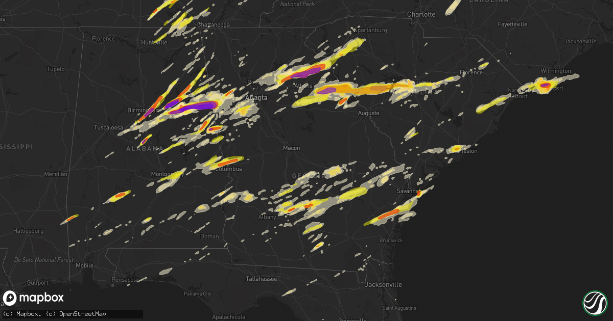
Hail Map in Georgia on April 5, 2017
Get this storm
April 5 map
$229
one time, instant access
Download today. No call, no setup
Keep the $229
Bought the map and want the full workflow? Apply the entire $229 to a subscription within 7 days. None of it is wasted.
Every map, not just this one
This buys you this map. Subscription and you get every map we run, in the markets you choose from a few cities to whole states to nationwide. Plus real-time alerts the moment a storm fires.
Contact data
Name, contact info, occupancy, even credit band for addresses in the footprint. You go from where it hit to who to call.
Become the source they trust
Unlimited branding weather history reports on demand. You already have the documented answer ready for the property owner, and you are the one who showed up with it.
Property data and RoofTrace estimates
Pull up any address you have got, its value and the exact code rules for that jurisdiction, straight from One Click Code. Then RoofTrace estimates the squares, pitch, and roof value, priced the way you price.
Storm reports in Georgia
Georgia
| Date | Description |
|---|---|
| 04/05/20176:30 PM CDT | Several trees reported down along grnatville road and bradbury rd. |
| 04/05/20175:53 PM CDT | Trees and power lines down around the city of douglas. Portion of a roof collapsed on a home in douglas. |
| 04/05/20175:45 PM CDT | Evans county warning point reports a large pine tree down across daisy nevils hwy. Time estimated from radar. |
| 04/05/20175:43 PM CDT | A local report indicates 1.00 inch wind near GLENN |
| 04/05/20175:18 PM CDT | Quarter to half dollar sized hail off sam beasley road |
| 04/05/20175:04 PM CDT | Tree reported down on hwy 117 southwest of lumber city. |
| 04/05/20175:04 PM CDT | Quarter-sized hail reported on fishing creek road |
| 04/05/20174:58 PM CDT | At intersection of hwy 27 and i-20. |
| 04/05/20174:50 PM CDT | Quarter to half dollar sized hail on i-20 at exit 5 |
| 04/05/20174:45 PM CDT | At intersection of hwy 16 and i-20. |
| 04/05/20174:43 PM CDT | Bulloch county 911 reported a tree down at the intersection of harville road and jim waters road |
| 04/05/20174:43 PM CDT | Trees down along the daisy nevills highway at mosley road. Time estimated based on radar. |
| 04/05/20174:40 PM CDT | Quarter-sized hail spotted in haralson county about a half mile south of i-20. |
| 04/05/20174:38 PM CDT | Screven county 911 reported a tree down on rocky ford rd. |
| 04/05/20174:34 PM CDT | Trees down along maria sorrel road...one leaning power pole. Roadway not blocked. |
| 04/05/20174:34 PM CDT | Bulloch county 911 reported a tree down at the intersection of maria sorrell road and bell road |
| 04/05/20174:24 PM CDT | Bulloch county 911 reported a tree down on w c hodges rd. |
| 04/05/20174:23 PM CDT | Bulloch county 911 reported a tree down on red fern lane near statesboro. |
| 04/05/20174:21 PM CDT | Bulloch county 911 reported a tree down on garfield street. |
| 04/05/20174:00 PM CDT | Emergency manager reports two trees down near george brinson road. |
| 04/05/20174:00 PM CDT | Emergency manager reports two trees down along george brinson road. |
| 04/05/20173:20 PM CDT | Emergency manager reports trees down. Eastern placement of reports based on radar. |
| 04/05/20173:01 PM CDT | Report of golf ball sized hail in ben hill county |
| 04/05/20172:45 PM CDT | Media relayed report and photo of golf ball size hail via twitter. |
| 04/05/20172:42 PM CDT | Trained spotter reported trees snapped and powerlines down along hwy 319. |
| 04/05/20172:40 PM CDT | Multiple trees and power lines down on james evans road. Structural damage to a home and a barn. |
| 04/05/20172:38 PM CDT | This was an ef2 tornado with a path length of 20.4 miles and a maximum path width of 400 yards. The estimated peak wind is 115 mph. |
| 04/05/20172:28 PM CDT | Spotter reports 1.25 inch hail in sycamore...edited for location |
| 04/05/20172:28 PM CDT | Spotter reports hail of 1 inch in ashburn |
| 04/05/20172:20 PM CDT | Quarter sized hail confirmed in arabi |
| 04/05/20172:16 PM CDT | Called about half dollar-sized hail in fairmount. |
| 04/05/20172:10 PM CDT | Public reports multiuple large trees blown down... 1 of which was blown onto a house. |
| 04/05/20172:05 PM CDT | An ef1 tornado with a path length of 8.9 miles and a maximum path width of 350 yards. The estimated peak wind was 105 mph. |
| 04/05/20171:46 PM CDT | Social media through broadcast media that a tree was down on power lines along west lake forest drive. |
| 04/05/20171:15 PM CDT | Several trees reported down across the southern portion of the county. |
| 04/05/20171:10 PM CDT | Lincoln county em reported golf-ball size hail occurring on greenwood church road near the county line. |
| 04/05/20171:10 PM CDT | Several trees reported down across the county. Position of report based on radar. |
| 04/05/201712:59 PM CDT | Roof blown off of a garage near intersection of franklin road and collier cemetary road |
| 04/05/201712:55 PM CDT | A strong ef1 tornado with a path length of 8.9 miles and a path width of 200 yards. The most substantial damage with this tornado occurred to a home along franklin road |
| 04/05/201712:44 PM CDT | Received a picture of golfball sized hail near rayle |
| 04/05/201712:40 PM CDT | An ef0 tornado briefly touched down southwest of the town of plains ga along ga-45 snapping a few trees. The tornado continued ne crossing n carter fishpond rd and chav |
| 04/05/201712:30 PM CDT | Quarter-sized hail reported in penfield ga |
| 04/05/201712:10 PM CDT | Emergency manager reports numerous trees and powerlines down across the county. |
| 04/05/201711:44 AM CDT | Damage reported to two structures along main street in weston. One building had roof removed and the other structure collapsed |
| 04/05/201711:26 AM CDT | Lincoln county em reported golf-ball size hail from goshen northward to the county line. |
| 04/05/201711:24 AM CDT | Mult reports to em of tornado sighted with damage |
| 04/05/201711:24 AM CDT | Multiple large trees were reported down... With one tree on a house. No injuries were reported. |
| 04/05/201711:15 AM CDT | Social media report of trees down along highway 11 sw of jefferson. |
| 04/05/201711:10 AM CDT | Half dollar-sized hail reported in tyrone. |
| 04/05/201711:09 AM CDT | Multiple houses damaged along wapakonata trail...trees on houses and cars...multiple powerlines and trees down |
| 04/05/201711:09 AM CDT | Multiple houses damaged along wapakonata trail...trees on houses...multiple powerlines and trees down |
| 04/05/201711:04 AM CDT | Tree down on house...possible tornado in the area |
| 04/05/201710:55 AM CDT | One inch hail reported in rayle with additional one inch hail in tignall. |
| 04/05/201710:55 AM CDT | One inch hail reported in tignall. |
| 04/05/201710:50 AM CDT | A tree was blown over in the road near the intersection of castle dr and gloster rd sw |
| 04/05/201710:48 AM CDT | Metal roof blown off of bilding...multiple trees down with home damage. Possible tornado sighting. |
| 04/05/201710:00 AM CDT | Social media report of one inch hail between villa rica and douglasville. |
| 04/05/20179:16 AM CDT | Small tree limbs down... Less than 2 inch in diameter. |
| 04/05/20179:15 AM CDT | Post event report from emergency manager of trees down across the county. Position based on radar. |
| 04/05/20179:00 AM CDT | Large tree down blocking deshong rd |
| 04/05/20177:44 AM CDT | Reports of golf ball sized hail was being reported by the fire chief in chattahoochee hills near the intersection of wilkerson mill rd and cascade palmetto hwy |
| 04/05/20171:25 AM CDT | Scattered power outages across waynesville area. Wind gusts estimated to 35-45 mph. |
| 04/05/20171:15 AM CDT | Tree down in st marys near ready street. Time estimated from radar. |
| 04/04/201711:02 PM CDT | Golf ball sized hail |
| 04/04/201711:00 PM CDT | Public reported quarter size hail on reed creek. |
| 04/04/201711:00 PM CDT | Emergency mngr reported about a half dozen homes damaged in southern hart county...two by falling trees and the others with roofs partially torn off. Numerous trees wer |
| 04/04/201711:00 PM CDT | Post storm report from emergency management of trees down near a car wash in social circle. |
| 04/04/201710:55 PM CDT | A local report indicates 1.75 inch wind near TYBEE ISLAND |
| 04/04/201710:52 PM CDT | A local report indicates 1.50 inch wind near TYBEE ISLAND |
| 04/04/201710:50 PM CDT | Observed near andrea drive. |
| 04/04/201710:50 PM CDT | Hail for about 10 minutes on jones avenue |
| 04/04/201710:45 PM CDT | Post storm report from emergency management of trees down near a car wash in social circle. |
| 04/04/201710:45 PM CDT | General public reported quarter size hail ssw of carnesville |
| 04/04/201710:38 PM CDT | Trees down at intersection of 14th street and w poplar street in griffin |
| 04/04/201710:35 PM CDT | Public reported quarter-sized hail at the quiktrip near commerce |
| 04/04/201710:30 PM CDT | A cocorahs spotter reported 1.75 inch sized hail. |
| 04/04/201710:25 PM CDT | Social media photo of hail noticably bigger than a golf ball in the preserve neighborhood near jefferson middle school |
| 04/04/201710:20 PM CDT | 1.50 inch hail was reported as well as estimated wind gusts to 50 mph. The hail was reported to last around 5-6 minutes. |
| 04/04/201710:10 PM CDT | Social media report of approximatly 1 inch hail in braselton at the intersection of i-85 and hwy 53 |
| 04/04/201710:08 PM CDT | Quarter sized hail and rainfall rates at 3.5 inches per hour at the hall county eoc |
| 04/04/201710:07 PM CDT | Ping pong ball sized hail reported in auburn ga |
| 04/04/201710:05 PM CDT | Social media report of approximatly 1 inch hail in braselton at the intersection of i-85 and hwy 53 |
| 04/04/201710:05 PM CDT | Trees and powerlines down along us-27 north of hamilton. Power out in parts of hamilton |
| 04/04/201710:00 PM CDT | Quarter-sized hail reported near ga-324 and ga-124. |
| 04/04/20179:25 PM CDT | Quarter sized hail reported in the pyne road area |
| 04/04/20178:50 PM CDT | 2 trees down in road at hwy 27 and hwy 5. |
| 04/04/20178:30 PM CDT | A power line was reported down near the intersection of marietta highway and riverside drive. |
| 04/04/20178:29 PM CDT | Golf ball sized hail reported near hwy 101 and hwy 120 in paulding county. |
| 04/04/20178:10 PM CDT | Tree and powerlines reported down in canton on oakdale road off of knox bridge highway |
| 04/04/20177:57 PM CDT | Tree down on vickers road |
| 04/04/20177:52 PM CDT | Tattnall county warning point reports one tree down on anderson st. Time estimated from radar |
| 04/04/20177:42 PM CDT | Tree down on bugle lane at highway 319. |
| 04/04/20177:30 PM CDT | Numerous trees and powerlines reported down across the county including several on darlington way. |
| 04/04/20177:30 PM CDT | Numerous trees and powerlines reported down across the county including numerous on garrard ave nw. |
| 04/04/20177:27 PM CDT | Em reported hail of 1.5 inches in the sirmans area of lanier county. |
| 04/04/20177:27 PM CDT | Hail of 1 inch reported in lanier county |
All States Impacted by Hail Map on April 5, 2017
Cities Impacted by Hail Map on April 5, 2017
- Wray, GA
- Ambrose, GA
- Fitzgerald, GA
- Broxton, GA
- Ocilla, GA
- Oak Island, NC
- Harned, KY
- Hardinsburg, KY
- Webster, KY
- Mammoth Cave, KY
- Bee Spring, KY
- Lineville, AL
- Dunmor, KY
- Belton, KY
- Morgantown, KY
- Orlinda, TN
- Rockfield, KY
- Woodburn, KY
- Oakland, KY
- Bowling Green, KY
- Brownsville, KY
- Springfield, TN
- Smiths Grove, KY
- Franklin, KY
- Park City, KY
- Gulf Breeze, FL
- Gordonsville, TN
- Moss, TN
- Watertown, TN
- Whitleyville, TN
- Carthage, TN
- Riddleton, TN
- Tompkinsville, KY
- Hartsville, TN
- Lafayette, TN
- Red Boiling Springs, TN
- Brush Creek, TN
- Lebanon, TN
- Elmwood, TN
- Pleasant Shade, TN
- Dixon Springs, TN
- Atlanta, GA
- Durham, NC
- Georgetown, SC
- Nesmith, SC
- Kingstree, SC
- Andrews, SC
- Hemingway, SC
- Waleska, GA
- Midland City, AL
- Newville, AL
- Lake View, SC
- Fairmont, NC
- Sonora, KY
- Upton, KY
- Dillon, SC
- Latta, SC
- Sellers, SC
- Farmersville, OH
- Centre, AL
- Vandalia, OH
- Stamping Ground, KY
- Georgetown, KY
- Midway, KY
- Sadieville, KY
- Frankfort, KY
- Leesville, SC
- Gaston, SC
- Pelion, SC
- Wagener, SC
- Lexington, SC
- Shelbyville, KY
- Bagdad, KY
- New Salisbury, IN
- Ramsey, IN
- Palmyra, IN
- Depauw, IN
- Winchester, KY
- Clay City, KY
- Jeffersonville, KY
- Adairville, KY
- Clayton, AL
- Clio, AL
- Ariton, AL
- Louisville, AL
- Shaw Afb, SC
- Rembert, SC
- Wedgefield, SC
- Cayce, SC
- Dalzell, SC
- Eastover, SC
- Hopkins, SC
- Columbia, SC
- West Columbia, SC
- Sumter, SC
- Gilbert, SC
- Birmingham, AL
- Leeds, AL
- Scottsville, KY
- Holland, KY
- Westminster, SC
- Seneca, SC
- Jacksonville, AL
- Reidsville, GA
- Uvalda, GA
- Hazlehurst, GA
- Lyons, GA
- Central, SC
- Roundhill, KY
- Cub Run, KY
- Clarkson, KY
- Sweeden, KY
- Anniston, AL
- Munford, AL
- Oxford, AL
- Talladega, AL
- Eastaboga, AL
- Eminence, KY
- Bethlehem, KY
- Lockport, KY
- Pleasureville, KY
- Owenton, KY
- Camden, AL
- Arabi, GA
- Ashburn, GA
- Alvaton, KY
- Midway, GA
- Prospect Hill, NC
- Leasburg, NC
- Pike Road, AL
- Gordon, AL
- Vincent, AL
- Sterrett, AL
- Glenwood, GA
- Soperton, GA
- Adrian, GA
- Dublin, GA
- Rockledge, GA
- East Dublin, GA
- Columbiana, AL
- Chelsea, AL
- Wilsonville, AL
- Greensburg, KY
- Thomson, GA
- Cedar Bluff, AL
- Piedmont, AL
- Gaylesville, AL
- Cordele, GA
- Riceville, TN
- Athens, TN
- Buffalo Valley, TN
- Silver Point, TN
- Bloomington, IN
- Bolivia, NC
- Supply, NC
- Starr, SC
- Canon, GA
- Danielsville, GA
- Pendergrass, GA
- Winder, GA
- Commerce, GA
- Hull, GA
- Dewy Rose, GA
- Talmo, GA
- Dacula, GA
- Gillsville, GA
- Jefferson, GA
- Auburn, GA
- Bowersville, GA
- Carnesville, GA
- Royston, GA
- Braselton, GA
- Buford, GA
- Iva, SC
- Gainesville, GA
- Hartwell, GA
- Lawrenceville, GA
- Hoschton, GA
- Maysville, GA
- Bowman, GA
- Flowery Branch, GA
- Lumpkin, GA
- Georgetown, GA
- Morris, GA
- Payneville, KY
- Brandenburg, KY
- Madison, GA
- Stephens, GA
- Greensboro, GA
- Watkinsville, GA
- Union Point, GA
- Newport, KY
- California, KY
- Cincinnati, OH
- Latonia, KY
- Batavia, OH
- New Richmond, OH
- Alexandria, KY
- Melbourne, KY
- Amelia, OH
- Morning View, KY
- Dayton, OH
- Rhine, GA
- Mount Orab, OH
- Fayetteville, OH
- Sardinia, OH
- Lynchburg, OH
- Roanoke, AL
- Wadley, AL
- Graham, AL
- Daviston, AL
- Alexander City, AL
- Bowdon, GA
- Woodland, AL
- Wedowee, AL
- Lincolnton, GA
- Lithia Springs, GA
- Douglasville, GA
- Austell, GA
- Winston, GA
- Gadsden, AL
- Wellington, AL
- Ohatchee, AL
- Muscadine, AL
- Bremen, GA
- Carrollton, GA
- Delta, AL
- Heflin, AL
- Waco, GA
- Ranburne, AL
- Elberton, GA
- Troy, SC
- Mount Carmel, SC
- McCormick, SC
- Carlton, GA
- Lexington, GA
- Rayle, GA
- Washington, GA
- Tignall, GA
- Sutherlin, VA
- Gibsonville, NC
- Milton, NC
- Pleasant Garden, NC
- Franklinville, NC
- Julian, NC
- Burlington, NC
- Climax, NC
- Liberty, NC
- Greensboro, NC
- Blanch, NC
- Alton, VA
- South Boston, VA
- Whitsett, NC
- Elon, NC
- Randleman, NC
- Yanceyville, NC
- McLeansville, NC
- Asheboro, NC
- Reidsville, NC
- Ringgold, VA
- Lakeland, GA
- Trussville, AL
- Rebecca, GA
- Sycamore, GA
- Rochelle, GA
- Lake Panasoffkee, FL
- Wildwood, FL
- Leitchfield, KY
- Temple, GA
- Villa Rica, GA
- Dallas, GA
- Dozier, AL
- Jemison, AL
- West Blocton, AL
- Vance, AL
- Woodstock, AL
- Bethel, OH
- Decherd, TN
- Ash, NC
- Southport, NC
- Carolina Beach, NC
- Shallotte, NC
- Wilmington, NC
- Sunset Beach, NC
- Longwood, NC
- Winnabow, NC
- Calabash, NC
- Ocean Isle Beach, NC
- Longs, SC
- Little River, SC
- Palmetto, GA
- Ranger, GA
- Fairmount, GA
- Versailles, KY
- Bradfordsville, KY
- Anderson, SC
- Lilburn, GA
- Oakwood, GA
- Alpharetta, GA
- Norcross, GA
- Cumming, GA
- Comer, GA
- Nicholson, GA
- Grayson, GA
- Tucker, GA
- Suwanee, GA
- Snellville, GA
- Defuniak Springs, FL
- Niceville, FL
- Holly Hill, SC
- Harleyville, SC
- Homerville, GA
- Naylor, GA
- Cochran, GA
- Baxter, TN
- Smithville, TN
- Cookeville, TN
- Gainesboro, TN
- Hilham, TN
- Bloomington Springs, TN
- Adams Run, SC
- Jacksonboro, SC
- Green Pond, SC
- Round O, SC
- Hernando, FL
- Dunnellon, FL
- Lexington, KY
- Nicholasville, KY
- Waco, KY
- Mount Sterling, KY
- Lancaster, KY
- Richmond, KY
- Brewton, AL
- Owingsville, KY
- Olympia, KY
- Salt Lick, KY
- Jesup, GA
- Richmond Hill, GA
- Riceboro, GA
- Savannah, GA
- Townsend, GA
- Ludowici, GA
- Fayetteville, TN
- Petersburg, TN
- Wartrace, TN
- Normandy, TN
- Manchester, TN
- Shelbyville, TN
- Tullahoma, TN
- Garfield, KY
- Irvington, KY
- McDaniels, KY
- Falls Of Rough, KY
- Westview, KY
- Eaton, OH
- Germantown, OH
- Bath, IN
- Hamilton, OH
- Middletown, OH
- West Alexandria, OH
- West College Corner, IN
- Miamisburg, OH
- Oxford, OH
- New Lebanon, OH
- Camden, OH
- Brookville, IN
- Tipp City, OH
- Fairborn, OH
- College Corner, OH
- Brookville, OH
- Somerville, OH
- Branchville, SC
- Cope, SC
- Bradyville, TN
- Woodbury, TN
- Inman, SC
- Lyman, SC
- Wellford, SC
- Alapaha, GA
- Willacoochee, GA
- Appling, GA
- Springville, AL
- Odenville, AL
- Frenchburg, KY
- Lithia, FL
- Conway, SC
- Palestine, WV
- Elizabeth, WV
- Bessemer, AL
- Bell Buckle, TN
- Murfreesboro, TN
- Christiana, TN
- Mulberry, FL
- Boston, KY
- Bardstown, KY
- Morehead, KY
- Wallingford, KY
- Liberty, KY
- Salem, IN
- Fredericksburg, IN
- Pekin, IN
- Corydon, IN
- Monetta, SC
- Ward, SC
- Modoc, SC
- Batesburg, SC
- Ridge Spring, SC
- Saluda, SC
- Edgefield, SC
- Johnston, SC
- Plum Branch, SC
- Williamsburg, OH
- Dexter, GA
- Cadwell, GA
- Smithville, GA
- Leesburg, GA
- Lincoln, AL
- Riverside, AL
- Pell City, AL
- Ragland, AL
- Alexandria, AL
- Saint Petersburg, FL
- Winchester, TN
- Estillfork, AL
- Cowan, TN
- Belvidere, TN
- Sewanee, TN
- Means, KY
- Bamberg, SC
- Olar, SC
- Ehrhardt, SC
- Dry Ridge, KY
- Crittenden, KY
- Marianna, FL
- Cottondale, FL
- Coy, AL
- Pine Hill, AL
- Fairfield, KY
- Elizabethtown, KY
- Lebanon Junction, KY
- Bloomfield, KY
- Taylorsville, KY
- Coxs Creek, KY
- Gurley, AL
- Huntsville, AL
- Rochester, KY
- Lewisburg, KY
- Leesburg, OH
- Greenfield, OH
- Decatur, GA
- Jakin, GA
- Moody, AL
- Summersville, KY
- Horse Branch, KY
- Cromwell, KY
- Lancaster, SC
- Pine Apple, AL
- Roswell, GA
- Weston, GA
- Dawson, GA
- Preston, GA
- Cuthbert, GA
- Richland, GA
- Parrott, GA
- Butler, KY
- Moscow, OH
- Hillsboro, OH
- Roopville, GA
- Georgetown, IN
- Lanesville, IN
- Senoia, GA
- Brooks, GA
- Peachtree City, GA
- Hampton, GA
- Fayetteville, GA
- Griffin, GA
- Beverly Hills, FL
- Brooksville, FL
- Lecanto, FL
- Inverness, FL
- Homosassa, FL
- Crystal River, FL
- Walterboro, SC
- Easley, SC
- Charleston, SC
- North Charleston, SC
- Opelika, AL
- Auburn, AL
- Pendleton, SC
- Galatia, IL
- Macedonia, IL
- Elba, AL
- Le Roy, WV
- Sandyville, WV
- Lodge, SC
- Sharpsburg, GA
- Newnan, GA
- Union City, GA
- Riverdale, GA
- Fairburn, GA
- Whitesburg, GA
- Tyrone, GA
- Rockford, AL
- Bishopville, SC
- Elliott, SC
- Lynchburg, SC
- Mayesville, SC
- Ramer, AL
- Montgomery, AL
- Letohatchee, AL
- Hope Hull, AL
- Franklin, GA
- McLeansboro, IL
- Milltown, IN
- Leavenworth, IN
- Collinsville, AL
- Fort Payne, AL
- Claxton, GA
- Lumber City, GA
- Collins, GA
- Baxley, GA
- Valley Head, AL
- Cataula, GA
- Waverly Hall, GA
- Ellerslie, GA
- Midland, GA
- Salem, AL
- Smiths Station, AL
- Phenix City, AL
- Columbus, GA
- Fortson, GA
- Johns Island, SC
- Hollywood, SC
- Mount Pleasant, SC
- Ravenel, SC
- Brooklet, GA
- Pembroke, GA
- Simpsonville, SC
- Lebanon, KY
- Gravel Switch, KY
- Campbellsville, KY
- Pineville, SC
- Saint Stephen, SC
- Rineyville, KY
- Shepherdsville, KY
- Big Clifty, KY
- Eastview, KY
- Cecilia, KY
- Glendale, KY
- Lafayette, AL
- Camp Hill, AL
- Ashland, AL
- Millerville, AL
- Goodwater, AL
- Grantville, GA
- Moreland, GA
- Magnolia, KY
- Bonnieville, KY
- Munfordville, KY
- Mount Sherman, KY
- Cross Plains, TN
- Cottontown, TN
- White House, TN
- McKenzie, AL
- Dadeville, AL
- Jacksons Gap, AL
- Lagrange, GA
- Five Points, AL
- Lanett, AL
- Sylvester, GA
- Pulaski, GA
- Metter, GA
- Springfield, GA
- Guyton, GA
- Burkesville, KY
- Albany, KY
- Buchanan, GA
- Tallapoosa, GA
- Cropwell, AL
- Harpersville, AL
- Fruithurst, AL
- Childersburg, AL
- Alpine, AL
- Tybee Island, GA
- Glasgow, KY
- Whitwell, TN
- Millry, AL
- State Line, MS
- Fountain Inn, SC
- Mount Washington, KY
- Cheshire, OH
- Apple Grove, WV
- Clemson, SC
- Townville, SC
- Steele, AL
- Helena, AL
- Attalla, AL
- Ashville, AL
- Perry, FL
- Varnville, SC
- Greenville, IN
- Memphis, IN
- Borden, IN
- Floyds Knobs, IN
- Henryville, IN
- Troy, NC
- New London, NC
- Badin, NC
- Albemarle, NC
- Shellman, GA
- Eufaula, AL
- Plains, GA
- Americus, GA
- Folkston, GA
- Apollo Beach, FL
- Ruskin, FL
- Abbeville, SC
- Greenwood, SC
- Glencoe, KY
- Jonesville, KY
- De Mossville, KY
- Falmouth, KY
- Corinth, KY
- Williamstown, KY
- Simpsonville, KY
- Powder Springs, GA
- Hiram, GA
- Bowling Green, FL
- Bartow, FL
- Homeland, FL
- Bradley, FL
- Mentone, AL
- Brundidge, AL
- Troy, AL
- Glenwood, AL
- Chester, GA
- Hawkinsville, GA
- Vidalia, GA
- Mount Vernon, GA
- Ailey, GA
- Tarrytown, GA
- Greensburg, IN
- Warwick, GA
- Abbeville, GA
- Horse Cave, KY
- Cave City, KY
- Hardyville, KY
- Elk Horn, KY
- Center, KY
- Springfield, OH
- South Vienna, OH
- Lyerly, GA
- Montevallo, AL
- Pelham, AL
- Alabaster, AL
- Brierfield, AL
- Poulan, GA
- Jacksonville, GA
- Milan, GA
- Oakfield, GA
- Swansea, SC
- Olive Hill, KY
- Bradley, SC
- Calhoun, GA
- Greensboro, AL
- Emerson, KY
- Grayson, KY
- Hillsboro, KY
- Stanton, KY
- Clearfield, KY
- Vanceburg, KY
- Hope, KY
- Williamston, SC
- Georgiana, AL
- Evergreen, AL
- Cobbtown, GA
- Kure Beach, NC
- North Myrtle Beach, SC
- Monroe, GA
- Loganville, GA
- Caneyville, KY
- Fordsville, KY
- Olaton, KY
- Guston, KY
- Beaver Dam, KY
- Morrison, TN
- Timmonsville, SC
- Florence, SC
- Darlington, SC
- Shorter, AL
- Rentz, GA
- Swainsboro, GA
- Pedro, OH
- North, SC
- Orangeburg, SC
- Saint Matthews, SC
- Oakboro, NC
- Norwood, NC
- Horton, AL
- Gainestown, AL
- Jackson, AL
- Talbotton, GA
- Enterprise, AL
- Talking Rock, GA
- Old Town, FL
- Sumner, GA
- Ty Ty, GA
- Tifton, GA
- Hodges, SC
- Dowelltown, TN
- Valley, AL
- Cedartown, GA
- Rockmart, GA
- Athens, GA
- Winterville, GA
- Bishop, GA
- Fairfax, SC
- Brunson, SC
- Ulmer, SC
- Allons, TN
- Livingston, TN
- Byrdstown, TN
- Celina, TN
- Hardeeville, SC
- Rincon, GA
- Granite Falls, NC
- Connelly Springs, NC
- Hickory, NC
- Merritt Island, FL
- Melbourne, FL
- Cocoa Beach, FL
- Cape Canaveral, FL
- Rockledge, FL
- Chattanooga, TN
- Douglas, GA
- Lenox, GA
- Nashville, GA
- Marietta, GA
- Grove Hill, AL
- Nashville, IN
- Maplesville, AL
- Register, GA
- McRae Helena, GA
- Pitts, GA
- Statesboro, GA
- Glennville, GA
- Clyo, GA
- Denton, GA
- Ellabell, GA
- Tillman, SC
- Garnett, SC
- Greenbrier, TN
- Knifley, KY
- Knob Lick, KY
- Gradyville, KY
- Mannsville, KY
- Edmonton, KY
- Dunnville, KY
- Columbia, KY
- Portland, TN
- Frisco City, AL
- Uriah, AL
- Cave Spring, GA
- New Market, AL
- Stevenson, AL
- Sherwood, TN
- Tracy City, TN
- Scottsboro, AL
- Princeton, AL
- South Pittsburg, TN
- Signal Mountain, TN
- Sequatchie, TN
- Dunlap, TN
- Fackler, AL
- Brownsboro, AL
- Wadmalaw Island, SC
- Edisto Island, SC
- Jasper, TN
- Pisgah, AL
- Flat Rock, AL
- Higdon, AL
- Ider, AL
- Henagar, AL
- Graysville, TN
- Statham, GA
- Trenton, GA
- Wildwood, GA
- Yemassee, SC
- Lumberton, NC
- Aiken, SC
- Lamar, SC
- Gadsden, SC
- Pelzer, SC
- Belton, SC
- Piedmont, SC
- Greenville, SC
- Mcminnville, TN
- Lawrenceburg, KY
- Waddy, KY
- Raywick, KY
- Blenheim, SC
- Middleburg, KY
- Repton, AL
- Calhoun Falls, SC
- Hogansville, GA
- Greenville, GA
- Newberry, IN
- Bloomfield, IN
- Live Oak, FL
- Lee, FL
- Valdosta, GA
- Rhodelia, KY
- Union Star, KY
- Pomaria, SC
- Westville, FL
- Ponce De Leon, FL
- Hillsboro, TN
- Little River, AL
- McIntosh, AL
- Kellyton, AL
- Geff, IL
- Notasulga, AL
- Jetson, KY
- Awendaw, SC
- Menlo, GA
- Highland Home, AL
- Tallassee, AL
- Mount Hermon, KY
- Cragford, AL
- Wetumpka, AL
- Aragon, GA
- Monteagle, TN
- Pelham, TN
- Navarre, FL
- Sellersburg, IN
- Horseshoe Beach, FL
- Early Branch, SC
- Ozark, AL
- Daleville, AL
- Fort Rucker, AL
- Newton, AL
- Fountain Run, KY
- Summer Shade, KY
- Adolphus, KY
- Westmoreland, TN
- Etoile, KY
- Marbury, AL
- Citronelle, AL
- Lower Peach Tree, AL
- Omaha, GA
- Midway, AL
- Hayneville, AL
- Lowndesboro, AL
- Russell Springs, KY
- Stockton, GA
- Du Pont, GA
- Buckhead, GA
- Newberry, SC
- Pinewood, SC
- Leslie, GA
- Gray Court, SC
- Barboursville, WV
- Milton, WV
- Ona, WV
- Colquitt, GA
- Altamont, TN
- Eclectic, AL
- Unadilla, GA
- Vienna, GA
- Buffalo, KY
- Slocomb, AL
- Thompsonville, IL
- Bluffton, GA
- Fort Gaines, GA
- Coleman, GA
- Sylvania, GA
- Saint Augustine, FL
- Rainbow City, AL
- McCalla, AL
- Rising Fawn, GA
- Portal, GA
- Tuskegee Institute, AL
- Union Springs, AL
- Tuskegee, AL
- Hurtsboro, AL
- Box Springs, GA
- Hatchechubbee, AL
- Twin City, GA
- Fraziers Bottom, WV
- Ashton, WV
- Leon, WV
- Southside, WV
- Evans, WV
- Cottageville, WV
- Gallipolis Ferry, WV
- Ripley, WV
- Weaver, AL
- Pittsboro, NC
- Chapel Hill, NC
- Eastman, GA
- Mauldin, SC
- Estill, SC
- Lake City, FL
- Rio Grande, OH
- Thurman, OH
- Patriot, OH
- Oak Hill, OH
- Gallipolis, OH
- Vinton, OH
- Bidwell, OH
- Meridianville, AL
- Goshen, OH
- Hamersville, OH
- Finchville, KY
- Louisville, KY
- Fisherville, KY
- Auburn, KY
- Russellville, KY
- Forest Park, GA
- Glens Fork, KY
- Whitesville, KY
- Newton, GA
- Albany, GA
- Springerton, IL
- Leesburg, AL
- Jonesboro, GA
- Red Level, AL
- Mount Eden, KY
- New Haven, KY
- West Point, KY
- Enigma, GA
- Paris, KY
- Commiskey, IN
- North Vernon, IN
- Cynthiana, KY
- Beersheba Springs, TN
- Crawford, GA
- Rutledge, GA
- Crawfordville, GA
- Clarks Hill, SC
- Norwood, GA
- Fort Deposit, AL
- Cecil, AL
- Graceville, FL
- Chipley, FL
- Baconton, GA
- Camilla, GA
- Bluffton, SC
- Creston, WV
- Covington, GA
- Lucedale, MS
- Lascassas, TN
- Auburntown, TN
- Milton, TN
- Duncanville, AL
- Vandiver, AL
- Calera, AL
- Mableton, GA
- Morrow, GA
- Cottondale, AL
- Smyrna, GA
- New Zion, SC
- Ridgeland, SC
- Greer, SC
- Peachtree Corners, GA
- Stone Mountain, GA
- Homer, GA
- Woodruff, SC
- Duluth, GA
- Myrtle Beach, SC
- Mcdonough, GA
- Verbena, AL
- Equality, AL
- Lithonia, GA
- Middleport, OH
- Bonifay, FL
- Alamo, GA
- Cross, SC
- Bell, FL
- Sparta, TN
- Union Mills, NC
- Bostic, NC
- Rutherfordton, NC
- Doerun, GA
- Olanta, SC
- Beechgrove, TN
- Readyville, TN
- Pearson, GA
- Sylacauga, AL
- Denton, NC
- Baldwin, GA
- Lula, GA
- Toccoa, GA
- Alto, GA
- Hardinsburg, IN
- Stem, NC
- Creedmoor, NC
- Butner, NC
- Saint Helena Island, SC
- Lawley, AL
- Randolph, AL
- Oxford, NC
- Foster, KY
- Ray City, GA
- Chauncey, GA
- Albertville, AL
- Guntersville, AL
- Elgin, SC
- Lugoff, SC
- Springfield, KY
- Yulee, FL
- Russell, KY
- Ashland, KY
- Argillite, KY
- Greenup, KY
- Worthington, KY
- Ironton, OH
- Flatwoods, KY
- Lynchburg, TN
- Scottown, OH
- Crown City, OH
- Beaufort, SC
- Hilton Head Island, SC
- Elora, TN
- Hazel Green, AL
- Castleberry, AL
- Moody Afb, GA
- Good Hope, GA
- Chickamauga, GA
- Rossville, GA
- Martin, GA
- Fair Play, SC
- Lavonia, GA
- Saint George, GA
- Bridgeport, AL
- Bethlehem, GA
- Hortense, GA
- Westport, IN
- Paint Lick, KY
- Spencer, TN
- Taylors, SC
- Trion, GA
- Summerville, GA
- Clanton, AL
- White Springs, FL
- Monroeville, AL
- Pelham, GA
- Caryville, FL
- Salley, SC
- Eighty Eight, KY
- Hilliard, FL
- Oxford, GA
- Conyers, GA
- Hodgenville, KY
- Brantley, AL
- Rydal, GA
- White, GA
- Huntland, TN
- Troy, OH
- Rainsville, AL
- Sylvania, AL
- Bryant, AL
- Reedy, WV
- Fort Meade, FL
- Wimauma, FL
- Riverview, FL
- Vine Grove, KY
- Waterloo, OH
- Sun City Center, FL
- De Soto, GA
- Pineview, GA
- Pinehurst, GA
- Cobb, GA
- Rock Island, TN
- Smithfield, KY
- Mount Vernon, AL
- Battletown, KY
- Rome, IN
- Hawesville, KY
- Cannelton, IN
- Mauckport, IN
- Central, IN
- Rocky Hill, KY
- White Mills, KY
- Cisne, IL
- Fairfield, IL
- Sims, IL
- Wayne City, IL
- Burnt Prairie, IL
- Barnhill, IL
- Enfield, IL
- Broughton, IL
- Dale, IL
- Mill Shoals, IL
- West Salem, IL
- Sumner, IL
- Claremont, IL
- Olney, IL
- Parkersburg, IL
- Calhoun, IL
- Bridgeport, IL
- Mount Erie, IL
- Alexandria, TN
- Flintville, TN
- Alpha, KY
- Gamaliel, KY
- Smoaks, SC
- Lynn, IN
- Minter, AL
- New Carlisle, OH
- Medway, OH
- New Vienna, OH
- Morganton, NC
- Valdese, NC
- Drexel, NC
- Sophia, NC
- Ruffin, NC
- Keeling, VA
- Apex, NC
- Screven, GA
- Colbert, GA
- Honea Path, SC


