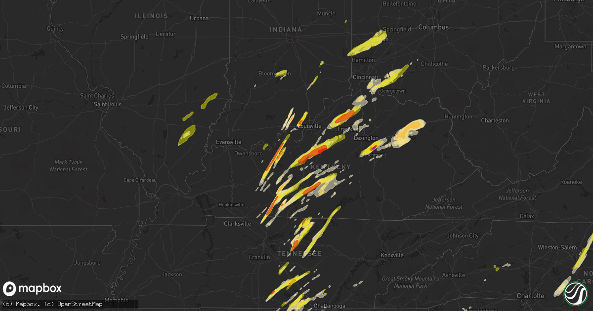
Hail Map in Kentucky on April 5, 2017
Get this storm
April 5 map
$229
one time, instant access
Download today. No call, no setup
Keep the $229
Bought the map and want the full workflow? Apply the entire $229 to a subscription within 7 days. None of it is wasted.
Every map, not just this one
This buys you this map. Subscription and you get every map we run, in the markets you choose from a few cities to whole states to nationwide. Plus real-time alerts the moment a storm fires.
Contact data
Name, contact info, occupancy, even credit band for addresses in the footprint. You go from where it hit to who to call.
Become the source they trust
Unlimited branding weather history reports on demand. You already have the documented answer ready for the property owner, and you are the one who showed up with it.
Property data and RoofTrace estimates
Pull up any address you have got, its value and the exact code rules for that jurisdiction, straight from One Click Code. Then RoofTrace estimates the squares, pitch, and roof value, priced the way you price.
Storm reports in Kentucky
Kentucky
| Date | Description |
|---|---|
| 04/05/20176:50 PM CDT | Shingles blown off a home. One inch tree limbs snapped. |
| 04/05/20176:35 PM CDT | Shingles torn off the roof of a house. |
| 04/05/20176:35 PM CDT | Trees down on power lines. 300 to 400 customers in jessamine county without power. |
| 04/05/20176:29 PM CDT | Reported at private weather station. |
| 04/05/20176:20 PM CDT | Trees and power lines down at hwy 34 and taylor rd. |
| 04/05/20176:15 PM CDT | Report of a roof off a house on spruce drive and ky state hwy 365. |
| 04/05/20176:14 PM CDT | Damage done to old barn. Sheeting thrown 400 yards. Minor damage to rohs opera house in cynthiana. |
| 04/05/20176:05 PM CDT | Twitter report of quarter-sized hail in georgetown. Time estimated based on radar and time of report. |
| 04/05/20176:05 PM CDT | Damage to roof reported at scott county high school. |
| 04/05/20176:04 PM CDT | Barn and tree damage. Sheeting thrown 400 yards. Estimated 70 mph winds. |
| 04/05/20176:04 PM CDT | Large barn heavily damaged along highway 62. |
| 04/05/20176:03 PM CDT | Scattered tree damage throughout county... Particularly in northern half. Time estimated from radar. |
| 04/05/20176:00 PM CDT | Trees down. |
| 04/05/20175:55 PM CDT | Damage to barns and outbuildings... Large limbs down along duvall station road. |
| 04/05/20175:55 PM CDT | Small tree limbs down. |
| 04/05/20175:54 PM CDT | Measured at private weather station. |
| 04/05/20175:47 PM CDT | Facebook report of tree's downed at gaddis ridge road and a barn damaged. Time estimated based on radar. |
| 04/05/20175:45 PM CDT | Trees down reported at pearidge rd... Frankfort... Ky. |
| 04/05/20175:43 PM CDT | A local report indicates 1.25 inch wind near 1 S CAMPBELLSVILLE |
| 04/05/20175:40 PM CDT | Tree down on daugherty ave and miller pike. |
| 04/05/20175:36 PM CDT | Tree down on race track rd. Couple of powerlines down in several locations throughout the county. Time estimated from radar. |
| 04/05/20175:34 PM CDT | A local report indicates 72 MPH wind near 2 NE ALTON |
| 04/05/20175:25 PM CDT | Trees down. |
| 04/05/20175:25 PM CDT | A local report indicates 1.75 inch wind near GREENSBURG |
| 04/05/20175:20 PM CDT | Large well built barn destroyed. Two small outbuildings and a fifth wheeler destroyed. Debris blown 1/4 mile to the northeast exhibited convergence and rotation. Cor to |
| 04/05/20175:20 PM CDT | Tore part of roof off barn. Tossed into road. Time estimated based on radar. |
| 04/05/20175:18 PM CDT | Building wall blown down. |
| 04/05/20175:17 PM CDT | Relayed viewer image of a tree uprooted. Time estimated based on radar. |
| 04/05/20175:16 PM CDT | Corrected time. Large well built barn destroyed. Two small outbuildings and a fifth wheeler destroyed. Debris blown 1/4 mile to the northeast exhibited convergence and |
| 04/05/20175:15 PM CDT | A local report indicates 1.00 inch wind near FAIRFIELD |
| 04/05/20175:14 PM CDT | Tree down on greenup rd. Barn debris from unknown source location also on greenup rd. Time estimated from radar. |
| 04/05/20175:13 PM CDT | Barns damaged...60 ft silo collapsed...tree damage. The duration of the tornado event was 2 minutes. |
| 04/05/20175:13 PM CDT | A local report indicates 1.00 inch wind near 7 NE CELINA |
| 04/05/20175:12 PM CDT | Tree damage. Well built barn destroyed and debris thrown one quarter mile. The duration of the tornado event was 1 minute. |
| 04/05/20175:12 PM CDT | Barn destroyed. |
| 04/05/20175:11 PM CDT | Corrected time. Barns damaged...60 ft silo collapsed...tree damage. |
| 04/05/20175:06 PM CDT | A local report indicates 1.75 inch wind near LOCKPORT |
| 04/05/20175:06 PM CDT | A local report indicates 1.00 inch wind near CROPPER |
| 04/05/20175:03 PM CDT | Barns flattened between glasgow and hiseville. |
| 04/05/20175:03 PM CDT | A local report indicates 1.75 inch wind near 2 W LOCKPORT |
| 04/05/20175:00 PM CDT | A local report indicates 1.00 inch wind near FAIRFIELD |
| 04/05/20175:00 PM CDT | A local report indicates 1.75 inch wind near BARDSTOWN |
| 04/05/20174:55 PM CDT | Damage to barns and outbuildings... Large limbs down along duvall station road. |
| 04/05/20174:55 PM CDT | Barns down along point pleasant road. |
| 04/05/20174:55 PM CDT | A local report indicates 1.00 inch wind near 1 ENE BETHLEHEM |
| 04/05/20174:54 PM CDT | Barns damaged... Garage door blown in. Anticyclonic tornado. Also hail damage to siding on homes. |
| 04/05/20174:53 PM CDT | A roof was blown off a modular home. Four to 5 barns were destroyed. A mobile home was destroyed near watkins lane. Trees were downed. Boards were peeled off a fence. |
| 04/05/20174:50 PM CDT | Trees down... Building damage... Power lines down. |
| 04/05/20174:47 PM CDT | A local report indicates 1.00 inch wind near BOSTON |
| 04/05/20174:46 PM CDT | A local report indicates 1.75 inch wind near ALVATON |
| 04/05/20174:45 PM CDT | A local report indicates 1.75 inch wind near BOSTON |
| 04/05/20174:34 PM CDT | Power lines down. |
| 04/05/20174:34 PM CDT | A local report indicates 1.75 inch wind near 4 ENE RICHARDSVILLE |
| 04/05/20174:30 PM CDT | Tree blown on to a mobile home in the woodland mobile home park. |
| 04/05/20174:30 PM CDT | Metal roof damage and a camper overturned along hwy 31w near ky 101. |
| 04/05/20174:30 PM CDT | Mobile home blown over. |
| 04/05/20174:30 PM CDT | A local report indicates 58 MPH wind near 4 SSW SIMPSONVILLE |
| 04/05/20174:29 PM CDT | Barn damaged. |
| 04/05/20174:27 PM CDT | Uprooted tree fell on roof of mobile home. Wind speed estimated 70-75 mph. |
| 04/05/20174:25 PM CDT | Roof sustained a fair amount of damage on home. Time estimated based on radar and approximate time of report from observer. |
| 04/05/20174:25 PM CDT | A local report indicates 1.00 inch wind near ELIZABETHTOWN |
| 04/05/20174:23 PM CDT | A local report indicates 1.75 inch wind near 1 NNW BOWLING GREEN |
| 04/05/20174:23 PM CDT | Veterans memorial parkway and morgantown road. |
| 04/05/20174:22 PM CDT | A local report indicates 1.00 inch wind near 2 W BOWLING GREEN |
| 04/05/20174:21 PM CDT | Power lines down on ky 79. |
| 04/05/20174:20 PM CDT | Large well built barn destroyed. Two small outbuildings and a fifth wheeler destroyed. Debris blown 1/4 mile to the northeast exhibited convergence and rotation. The du |
| 04/05/20174:18 PM CDT | Trees damaged. Report via mping. Time estimated based on radar... Which had two cells go over that area. Used the stronger second cell. |
| 04/05/20174:17 PM CDT | Power lines down. |
| 04/05/20174:17 PM CDT | A local report indicates 1.00 inch wind near 3 WSW WINDYVILLE |
| 04/05/20174:10 PM CDT | Shingles off a home near warren east high school. |
| 04/05/20174:10 PM CDT | A local report indicates 62 MPH wind near 1 SE PLUM SPRINGS |
| 04/05/20173:28 PM CDT | Near horse branch. |
| 04/05/20173:18 PM CDT | Twitter report relayed from viewer of quarter-sized hail and smaller in cromwell. Time estimated based on radar. |
| 04/05/20172:58 PM CDT | A local report indicates 1.50 inch wind near HARNED |
| 04/04/20179:10 PM CDT | Several trees down |
| 04/04/20178:55 PM CDT | Tree down - time estimated from radar |
| 04/04/20178:50 PM CDT | Tree down -- time estimated from radar |
| 04/04/20178:50 PM CDT | Several trees down throughout carter county. |
| 04/04/20178:42 PM CDT | Trees down in the fallsburg area |
| 04/04/20178:38 PM CDT | One tree down up buck creek/hwy 3329. |
| 04/04/20178:30 PM CDT | One tree down on hwy 649. |
| 04/04/20178:25 PM CDT | One tree down and tree debris in the road on hwy 711. |
| 04/04/20178:12 PM CDT | Trees down at intersection of amos ridge road and highway 460 e. |
| 04/04/20178:12 PM CDT | Trees down on christian street. |
| 04/04/20178:07 PM CDT | Measured at a private weather station east of berea. |
| 04/04/20178:06 PM CDT | Trees down on highway 1722. |
| 04/04/20178:06 PM CDT | Trees down on hawkins branch road. |
| 04/04/20178:00 PM CDT | Trees down on oakley peeble road near intersection with hwy 111. |
| 04/04/20178:00 PM CDT | Two trees down on hwy 713 and 3339 with large limbs down throughout the county. |
| 04/04/20177:55 PM CDT | Trees down on highway 60. Power lines down in salt lick and olympia springs. |
| 04/04/20177:54 PM CDT | Trees down on highway 36 east at olympia. |
| 04/04/20177:48 PM CDT | Two trees down at intersections of main street and science ridge road. |
| 04/04/20177:48 PM CDT | Trees down on highway 60. Power lines down in salt lick and olympia springs. |
| 04/04/20177:46 PM CDT | Trees down. |
| 04/04/20177:37 PM CDT | Trees down on highway 82. |
| 04/04/20177:22 PM CDT | Many shingles off a roof and garage door caved in on diamond brook drive. |
| 04/04/20177:22 PM CDT | Trees down at several locations on union city road... Including one older tree on the roof of a shed. Minor siding and roof damage on diamond brook drive. |
| 04/04/20177:20 PM CDT | Twitter report |
| 04/04/20177:17 PM CDT | Power lines down. Tree on a house. |
| 04/04/20177:07 PM CDT | Hail half inch to quarter size. |
| 04/04/20177:07 PM CDT | Reported through mping. Time estimated based on radar. |
| 04/04/20177:05 PM CDT | Twitter report at exit 97 on i-75 north of richmond. |
| 04/04/20177:05 PM CDT | Reported through mping. Time estimated based on radar. |
| 04/04/20177:05 PM CDT | Also had a window pane blown out and some shingles damaged. |
| 04/04/20177:04 PM CDT | A local report indicates 2.00 inch wind near 2 ESE VALLEY VIEW |
All States Impacted by Hail Map on April 5, 2017
Cities Impacted by Hail Map on April 5, 2017
- Wray, GA
- Ambrose, GA
- Fitzgerald, GA
- Broxton, GA
- Ocilla, GA
- Oak Island, NC
- Harned, KY
- Hardinsburg, KY
- Webster, KY
- Mammoth Cave, KY
- Bee Spring, KY
- Lineville, AL
- Dunmor, KY
- Belton, KY
- Morgantown, KY
- Orlinda, TN
- Rockfield, KY
- Woodburn, KY
- Oakland, KY
- Bowling Green, KY
- Brownsville, KY
- Springfield, TN
- Smiths Grove, KY
- Franklin, KY
- Park City, KY
- Gulf Breeze, FL
- Gordonsville, TN
- Moss, TN
- Watertown, TN
- Whitleyville, TN
- Carthage, TN
- Riddleton, TN
- Tompkinsville, KY
- Hartsville, TN
- Lafayette, TN
- Red Boiling Springs, TN
- Brush Creek, TN
- Lebanon, TN
- Elmwood, TN
- Pleasant Shade, TN
- Dixon Springs, TN
- Atlanta, GA
- Durham, NC
- Georgetown, SC
- Nesmith, SC
- Kingstree, SC
- Andrews, SC
- Hemingway, SC
- Waleska, GA
- Midland City, AL
- Newville, AL
- Lake View, SC
- Fairmont, NC
- Sonora, KY
- Upton, KY
- Dillon, SC
- Latta, SC
- Sellers, SC
- Farmersville, OH
- Centre, AL
- Vandalia, OH
- Stamping Ground, KY
- Georgetown, KY
- Midway, KY
- Sadieville, KY
- Frankfort, KY
- Leesville, SC
- Gaston, SC
- Pelion, SC
- Wagener, SC
- Lexington, SC
- Shelbyville, KY
- Bagdad, KY
- New Salisbury, IN
- Ramsey, IN
- Palmyra, IN
- Depauw, IN
- Winchester, KY
- Clay City, KY
- Jeffersonville, KY
- Adairville, KY
- Clayton, AL
- Clio, AL
- Ariton, AL
- Louisville, AL
- Shaw Afb, SC
- Rembert, SC
- Wedgefield, SC
- Cayce, SC
- Dalzell, SC
- Eastover, SC
- Hopkins, SC
- Columbia, SC
- West Columbia, SC
- Sumter, SC
- Gilbert, SC
- Birmingham, AL
- Leeds, AL
- Scottsville, KY
- Holland, KY
- Westminster, SC
- Seneca, SC
- Jacksonville, AL
- Reidsville, GA
- Uvalda, GA
- Hazlehurst, GA
- Lyons, GA
- Central, SC
- Roundhill, KY
- Cub Run, KY
- Clarkson, KY
- Sweeden, KY
- Anniston, AL
- Munford, AL
- Oxford, AL
- Talladega, AL
- Eastaboga, AL
- Eminence, KY
- Bethlehem, KY
- Lockport, KY
- Pleasureville, KY
- Owenton, KY
- Camden, AL
- Arabi, GA
- Ashburn, GA
- Alvaton, KY
- Midway, GA
- Prospect Hill, NC
- Leasburg, NC
- Pike Road, AL
- Gordon, AL
- Vincent, AL
- Sterrett, AL
- Glenwood, GA
- Soperton, GA
- Adrian, GA
- Dublin, GA
- Rockledge, GA
- East Dublin, GA
- Columbiana, AL
- Chelsea, AL
- Wilsonville, AL
- Greensburg, KY
- Thomson, GA
- Cedar Bluff, AL
- Piedmont, AL
- Gaylesville, AL
- Cordele, GA
- Riceville, TN
- Athens, TN
- Buffalo Valley, TN
- Silver Point, TN
- Bloomington, IN
- Bolivia, NC
- Supply, NC
- Starr, SC
- Canon, GA
- Danielsville, GA
- Pendergrass, GA
- Winder, GA
- Commerce, GA
- Hull, GA
- Dewy Rose, GA
- Talmo, GA
- Dacula, GA
- Gillsville, GA
- Jefferson, GA
- Auburn, GA
- Bowersville, GA
- Carnesville, GA
- Royston, GA
- Braselton, GA
- Buford, GA
- Iva, SC
- Gainesville, GA
- Hartwell, GA
- Lawrenceville, GA
- Hoschton, GA
- Maysville, GA
- Bowman, GA
- Flowery Branch, GA
- Lumpkin, GA
- Georgetown, GA
- Morris, GA
- Payneville, KY
- Brandenburg, KY
- Madison, GA
- Stephens, GA
- Greensboro, GA
- Watkinsville, GA
- Union Point, GA
- Newport, KY
- California, KY
- Cincinnati, OH
- Latonia, KY
- Batavia, OH
- New Richmond, OH
- Alexandria, KY
- Melbourne, KY
- Amelia, OH
- Morning View, KY
- Dayton, OH
- Rhine, GA
- Mount Orab, OH
- Fayetteville, OH
- Sardinia, OH
- Lynchburg, OH
- Roanoke, AL
- Wadley, AL
- Graham, AL
- Daviston, AL
- Alexander City, AL
- Bowdon, GA
- Woodland, AL
- Wedowee, AL
- Lincolnton, GA
- Lithia Springs, GA
- Douglasville, GA
- Austell, GA
- Winston, GA
- Gadsden, AL
- Wellington, AL
- Ohatchee, AL
- Muscadine, AL
- Bremen, GA
- Carrollton, GA
- Delta, AL
- Heflin, AL
- Waco, GA
- Ranburne, AL
- Elberton, GA
- Troy, SC
- Mount Carmel, SC
- McCormick, SC
- Carlton, GA
- Lexington, GA
- Rayle, GA
- Washington, GA
- Tignall, GA
- Sutherlin, VA
- Gibsonville, NC
- Milton, NC
- Pleasant Garden, NC
- Franklinville, NC
- Julian, NC
- Burlington, NC
- Climax, NC
- Liberty, NC
- Greensboro, NC
- Blanch, NC
- Alton, VA
- South Boston, VA
- Whitsett, NC
- Elon, NC
- Randleman, NC
- Yanceyville, NC
- McLeansville, NC
- Asheboro, NC
- Reidsville, NC
- Ringgold, VA
- Lakeland, GA
- Trussville, AL
- Rebecca, GA
- Sycamore, GA
- Rochelle, GA
- Lake Panasoffkee, FL
- Wildwood, FL
- Leitchfield, KY
- Temple, GA
- Villa Rica, GA
- Dallas, GA
- Dozier, AL
- Jemison, AL
- West Blocton, AL
- Vance, AL
- Woodstock, AL
- Bethel, OH
- Decherd, TN
- Ash, NC
- Southport, NC
- Carolina Beach, NC
- Shallotte, NC
- Wilmington, NC
- Sunset Beach, NC
- Longwood, NC
- Winnabow, NC
- Calabash, NC
- Ocean Isle Beach, NC
- Longs, SC
- Little River, SC
- Palmetto, GA
- Ranger, GA
- Fairmount, GA
- Versailles, KY
- Bradfordsville, KY
- Anderson, SC
- Lilburn, GA
- Oakwood, GA
- Alpharetta, GA
- Norcross, GA
- Cumming, GA
- Comer, GA
- Nicholson, GA
- Grayson, GA
- Tucker, GA
- Suwanee, GA
- Snellville, GA
- Defuniak Springs, FL
- Niceville, FL
- Holly Hill, SC
- Harleyville, SC
- Homerville, GA
- Naylor, GA
- Cochran, GA
- Baxter, TN
- Smithville, TN
- Cookeville, TN
- Gainesboro, TN
- Hilham, TN
- Bloomington Springs, TN
- Adams Run, SC
- Jacksonboro, SC
- Green Pond, SC
- Round O, SC
- Hernando, FL
- Dunnellon, FL
- Lexington, KY
- Nicholasville, KY
- Waco, KY
- Mount Sterling, KY
- Lancaster, KY
- Richmond, KY
- Brewton, AL
- Owingsville, KY
- Olympia, KY
- Salt Lick, KY
- Jesup, GA
- Richmond Hill, GA
- Riceboro, GA
- Savannah, GA
- Townsend, GA
- Ludowici, GA
- Fayetteville, TN
- Petersburg, TN
- Wartrace, TN
- Normandy, TN
- Manchester, TN
- Shelbyville, TN
- Tullahoma, TN
- Garfield, KY
- Irvington, KY
- McDaniels, KY
- Falls Of Rough, KY
- Westview, KY
- Eaton, OH
- Germantown, OH
- Bath, IN
- Hamilton, OH
- Middletown, OH
- West Alexandria, OH
- West College Corner, IN
- Miamisburg, OH
- Oxford, OH
- New Lebanon, OH
- Camden, OH
- Brookville, IN
- Tipp City, OH
- Fairborn, OH
- College Corner, OH
- Brookville, OH
- Somerville, OH
- Branchville, SC
- Cope, SC
- Bradyville, TN
- Woodbury, TN
- Inman, SC
- Lyman, SC
- Wellford, SC
- Alapaha, GA
- Willacoochee, GA
- Appling, GA
- Springville, AL
- Odenville, AL
- Frenchburg, KY
- Lithia, FL
- Conway, SC
- Palestine, WV
- Elizabeth, WV
- Bessemer, AL
- Bell Buckle, TN
- Murfreesboro, TN
- Christiana, TN
- Mulberry, FL
- Boston, KY
- Bardstown, KY
- Morehead, KY
- Wallingford, KY
- Liberty, KY
- Salem, IN
- Fredericksburg, IN
- Pekin, IN
- Corydon, IN
- Monetta, SC
- Ward, SC
- Modoc, SC
- Batesburg, SC
- Ridge Spring, SC
- Saluda, SC
- Edgefield, SC
- Johnston, SC
- Plum Branch, SC
- Williamsburg, OH
- Dexter, GA
- Cadwell, GA
- Smithville, GA
- Leesburg, GA
- Lincoln, AL
- Riverside, AL
- Pell City, AL
- Ragland, AL
- Alexandria, AL
- Saint Petersburg, FL
- Winchester, TN
- Estillfork, AL
- Cowan, TN
- Belvidere, TN
- Sewanee, TN
- Means, KY
- Bamberg, SC
- Olar, SC
- Ehrhardt, SC
- Dry Ridge, KY
- Crittenden, KY
- Marianna, FL
- Cottondale, FL
- Coy, AL
- Pine Hill, AL
- Fairfield, KY
- Elizabethtown, KY
- Lebanon Junction, KY
- Bloomfield, KY
- Taylorsville, KY
- Coxs Creek, KY
- Gurley, AL
- Huntsville, AL
- Rochester, KY
- Lewisburg, KY
- Leesburg, OH
- Greenfield, OH
- Decatur, GA
- Jakin, GA
- Moody, AL
- Summersville, KY
- Horse Branch, KY
- Cromwell, KY
- Lancaster, SC
- Pine Apple, AL
- Roswell, GA
- Weston, GA
- Dawson, GA
- Preston, GA
- Cuthbert, GA
- Richland, GA
- Parrott, GA
- Butler, KY
- Moscow, OH
- Hillsboro, OH
- Roopville, GA
- Georgetown, IN
- Lanesville, IN
- Senoia, GA
- Brooks, GA
- Peachtree City, GA
- Hampton, GA
- Fayetteville, GA
- Griffin, GA
- Beverly Hills, FL
- Brooksville, FL
- Lecanto, FL
- Inverness, FL
- Homosassa, FL
- Crystal River, FL
- Walterboro, SC
- Easley, SC
- Charleston, SC
- North Charleston, SC
- Opelika, AL
- Auburn, AL
- Pendleton, SC
- Galatia, IL
- Macedonia, IL
- Elba, AL
- Le Roy, WV
- Sandyville, WV
- Lodge, SC
- Sharpsburg, GA
- Newnan, GA
- Union City, GA
- Riverdale, GA
- Fairburn, GA
- Whitesburg, GA
- Tyrone, GA
- Rockford, AL
- Bishopville, SC
- Elliott, SC
- Lynchburg, SC
- Mayesville, SC
- Ramer, AL
- Montgomery, AL
- Letohatchee, AL
- Hope Hull, AL
- Franklin, GA
- McLeansboro, IL
- Milltown, IN
- Leavenworth, IN
- Collinsville, AL
- Fort Payne, AL
- Claxton, GA
- Lumber City, GA
- Collins, GA
- Baxley, GA
- Valley Head, AL
- Cataula, GA
- Waverly Hall, GA
- Ellerslie, GA
- Midland, GA
- Salem, AL
- Smiths Station, AL
- Phenix City, AL
- Columbus, GA
- Fortson, GA
- Johns Island, SC
- Hollywood, SC
- Mount Pleasant, SC
- Ravenel, SC
- Brooklet, GA
- Pembroke, GA
- Simpsonville, SC
- Lebanon, KY
- Gravel Switch, KY
- Campbellsville, KY
- Pineville, SC
- Saint Stephen, SC
- Rineyville, KY
- Shepherdsville, KY
- Big Clifty, KY
- Eastview, KY
- Cecilia, KY
- Glendale, KY
- Lafayette, AL
- Camp Hill, AL
- Ashland, AL
- Millerville, AL
- Goodwater, AL
- Grantville, GA
- Moreland, GA
- Magnolia, KY
- Bonnieville, KY
- Munfordville, KY
- Mount Sherman, KY
- Cross Plains, TN
- Cottontown, TN
- White House, TN
- McKenzie, AL
- Dadeville, AL
- Jacksons Gap, AL
- Lagrange, GA
- Five Points, AL
- Lanett, AL
- Sylvester, GA
- Pulaski, GA
- Metter, GA
- Springfield, GA
- Guyton, GA
- Burkesville, KY
- Albany, KY
- Buchanan, GA
- Tallapoosa, GA
- Cropwell, AL
- Harpersville, AL
- Fruithurst, AL
- Childersburg, AL
- Alpine, AL
- Tybee Island, GA
- Glasgow, KY
- Whitwell, TN
- Millry, AL
- State Line, MS
- Fountain Inn, SC
- Mount Washington, KY
- Cheshire, OH
- Apple Grove, WV
- Clemson, SC
- Townville, SC
- Steele, AL
- Helena, AL
- Attalla, AL
- Ashville, AL
- Perry, FL
- Varnville, SC
- Greenville, IN
- Memphis, IN
- Borden, IN
- Floyds Knobs, IN
- Henryville, IN
- Troy, NC
- New London, NC
- Badin, NC
- Albemarle, NC
- Shellman, GA
- Eufaula, AL
- Plains, GA
- Americus, GA
- Folkston, GA
- Apollo Beach, FL
- Ruskin, FL
- Abbeville, SC
- Greenwood, SC
- Glencoe, KY
- Jonesville, KY
- De Mossville, KY
- Falmouth, KY
- Corinth, KY
- Williamstown, KY
- Simpsonville, KY
- Powder Springs, GA
- Hiram, GA
- Bowling Green, FL
- Bartow, FL
- Homeland, FL
- Bradley, FL
- Mentone, AL
- Brundidge, AL
- Troy, AL
- Glenwood, AL
- Chester, GA
- Hawkinsville, GA
- Vidalia, GA
- Mount Vernon, GA
- Ailey, GA
- Tarrytown, GA
- Greensburg, IN
- Warwick, GA
- Abbeville, GA
- Horse Cave, KY
- Cave City, KY
- Hardyville, KY
- Elk Horn, KY
- Center, KY
- Springfield, OH
- South Vienna, OH
- Lyerly, GA
- Montevallo, AL
- Pelham, AL
- Alabaster, AL
- Brierfield, AL
- Poulan, GA
- Jacksonville, GA
- Milan, GA
- Oakfield, GA
- Swansea, SC
- Olive Hill, KY
- Bradley, SC
- Calhoun, GA
- Greensboro, AL
- Emerson, KY
- Grayson, KY
- Hillsboro, KY
- Stanton, KY
- Clearfield, KY
- Vanceburg, KY
- Hope, KY
- Williamston, SC
- Georgiana, AL
- Evergreen, AL
- Cobbtown, GA
- Kure Beach, NC
- North Myrtle Beach, SC
- Monroe, GA
- Loganville, GA
- Caneyville, KY
- Fordsville, KY
- Olaton, KY
- Guston, KY
- Beaver Dam, KY
- Morrison, TN
- Timmonsville, SC
- Florence, SC
- Darlington, SC
- Shorter, AL
- Rentz, GA
- Swainsboro, GA
- Pedro, OH
- North, SC
- Orangeburg, SC
- Saint Matthews, SC
- Oakboro, NC
- Norwood, NC
- Horton, AL
- Gainestown, AL
- Jackson, AL
- Talbotton, GA
- Enterprise, AL
- Talking Rock, GA
- Old Town, FL
- Sumner, GA
- Ty Ty, GA
- Tifton, GA
- Hodges, SC
- Dowelltown, TN
- Valley, AL
- Cedartown, GA
- Rockmart, GA
- Athens, GA
- Winterville, GA
- Bishop, GA
- Fairfax, SC
- Brunson, SC
- Ulmer, SC
- Allons, TN
- Livingston, TN
- Byrdstown, TN
- Celina, TN
- Hardeeville, SC
- Rincon, GA
- Granite Falls, NC
- Connelly Springs, NC
- Hickory, NC
- Merritt Island, FL
- Melbourne, FL
- Cocoa Beach, FL
- Cape Canaveral, FL
- Rockledge, FL
- Chattanooga, TN
- Douglas, GA
- Lenox, GA
- Nashville, GA
- Marietta, GA
- Grove Hill, AL
- Nashville, IN
- Maplesville, AL
- Register, GA
- McRae Helena, GA
- Pitts, GA
- Statesboro, GA
- Glennville, GA
- Clyo, GA
- Denton, GA
- Ellabell, GA
- Tillman, SC
- Garnett, SC
- Greenbrier, TN
- Knifley, KY
- Knob Lick, KY
- Gradyville, KY
- Mannsville, KY
- Edmonton, KY
- Dunnville, KY
- Columbia, KY
- Portland, TN
- Frisco City, AL
- Uriah, AL
- Cave Spring, GA
- New Market, AL
- Stevenson, AL
- Sherwood, TN
- Tracy City, TN
- Scottsboro, AL
- Princeton, AL
- South Pittsburg, TN
- Signal Mountain, TN
- Sequatchie, TN
- Dunlap, TN
- Fackler, AL
- Brownsboro, AL
- Wadmalaw Island, SC
- Edisto Island, SC
- Jasper, TN
- Pisgah, AL
- Flat Rock, AL
- Higdon, AL
- Ider, AL
- Henagar, AL
- Graysville, TN
- Statham, GA
- Trenton, GA
- Wildwood, GA
- Yemassee, SC
- Lumberton, NC
- Aiken, SC
- Lamar, SC
- Gadsden, SC
- Pelzer, SC
- Belton, SC
- Piedmont, SC
- Greenville, SC
- Mcminnville, TN
- Lawrenceburg, KY
- Waddy, KY
- Raywick, KY
- Blenheim, SC
- Middleburg, KY
- Repton, AL
- Calhoun Falls, SC
- Hogansville, GA
- Greenville, GA
- Newberry, IN
- Bloomfield, IN
- Live Oak, FL
- Lee, FL
- Valdosta, GA
- Rhodelia, KY
- Union Star, KY
- Pomaria, SC
- Westville, FL
- Ponce De Leon, FL
- Hillsboro, TN
- Little River, AL
- McIntosh, AL
- Kellyton, AL
- Geff, IL
- Notasulga, AL
- Jetson, KY
- Awendaw, SC
- Menlo, GA
- Highland Home, AL
- Tallassee, AL
- Mount Hermon, KY
- Cragford, AL
- Wetumpka, AL
- Aragon, GA
- Monteagle, TN
- Pelham, TN
- Navarre, FL
- Sellersburg, IN
- Horseshoe Beach, FL
- Early Branch, SC
- Ozark, AL
- Daleville, AL
- Fort Rucker, AL
- Newton, AL
- Fountain Run, KY
- Summer Shade, KY
- Adolphus, KY
- Westmoreland, TN
- Etoile, KY
- Marbury, AL
- Citronelle, AL
- Lower Peach Tree, AL
- Omaha, GA
- Midway, AL
- Hayneville, AL
- Lowndesboro, AL
- Russell Springs, KY
- Stockton, GA
- Du Pont, GA
- Buckhead, GA
- Newberry, SC
- Pinewood, SC
- Leslie, GA
- Gray Court, SC
- Barboursville, WV
- Milton, WV
- Ona, WV
- Colquitt, GA
- Altamont, TN
- Eclectic, AL
- Unadilla, GA
- Vienna, GA
- Buffalo, KY
- Slocomb, AL
- Thompsonville, IL
- Bluffton, GA
- Fort Gaines, GA
- Coleman, GA
- Sylvania, GA
- Saint Augustine, FL
- Rainbow City, AL
- McCalla, AL
- Rising Fawn, GA
- Portal, GA
- Tuskegee Institute, AL
- Union Springs, AL
- Tuskegee, AL
- Hurtsboro, AL
- Box Springs, GA
- Hatchechubbee, AL
- Twin City, GA
- Fraziers Bottom, WV
- Ashton, WV
- Leon, WV
- Southside, WV
- Evans, WV
- Cottageville, WV
- Gallipolis Ferry, WV
- Ripley, WV
- Weaver, AL
- Pittsboro, NC
- Chapel Hill, NC
- Eastman, GA
- Mauldin, SC
- Estill, SC
- Lake City, FL
- Rio Grande, OH
- Thurman, OH
- Patriot, OH
- Oak Hill, OH
- Gallipolis, OH
- Vinton, OH
- Bidwell, OH
- Meridianville, AL
- Goshen, OH
- Hamersville, OH
- Finchville, KY
- Louisville, KY
- Fisherville, KY
- Auburn, KY
- Russellville, KY
- Forest Park, GA
- Glens Fork, KY
- Whitesville, KY
- Newton, GA
- Albany, GA
- Springerton, IL
- Leesburg, AL
- Jonesboro, GA
- Red Level, AL
- Mount Eden, KY
- New Haven, KY
- West Point, KY
- Enigma, GA
- Paris, KY
- Commiskey, IN
- North Vernon, IN
- Cynthiana, KY
- Beersheba Springs, TN
- Crawford, GA
- Rutledge, GA
- Crawfordville, GA
- Clarks Hill, SC
- Norwood, GA
- Fort Deposit, AL
- Cecil, AL
- Graceville, FL
- Chipley, FL
- Baconton, GA
- Camilla, GA
- Bluffton, SC
- Creston, WV
- Covington, GA
- Lucedale, MS
- Lascassas, TN
- Auburntown, TN
- Milton, TN
- Duncanville, AL
- Vandiver, AL
- Calera, AL
- Mableton, GA
- Morrow, GA
- Cottondale, AL
- Smyrna, GA
- New Zion, SC
- Ridgeland, SC
- Greer, SC
- Peachtree Corners, GA
- Stone Mountain, GA
- Homer, GA
- Woodruff, SC
- Duluth, GA
- Myrtle Beach, SC
- Mcdonough, GA
- Verbena, AL
- Equality, AL
- Lithonia, GA
- Middleport, OH
- Bonifay, FL
- Alamo, GA
- Cross, SC
- Bell, FL
- Sparta, TN
- Union Mills, NC
- Bostic, NC
- Rutherfordton, NC
- Doerun, GA
- Olanta, SC
- Beechgrove, TN
- Readyville, TN
- Pearson, GA
- Sylacauga, AL
- Denton, NC
- Baldwin, GA
- Lula, GA
- Toccoa, GA
- Alto, GA
- Hardinsburg, IN
- Stem, NC
- Creedmoor, NC
- Butner, NC
- Saint Helena Island, SC
- Lawley, AL
- Randolph, AL
- Oxford, NC
- Foster, KY
- Ray City, GA
- Chauncey, GA
- Albertville, AL
- Guntersville, AL
- Elgin, SC
- Lugoff, SC
- Springfield, KY
- Yulee, FL
- Russell, KY
- Ashland, KY
- Argillite, KY
- Greenup, KY
- Worthington, KY
- Ironton, OH
- Flatwoods, KY
- Lynchburg, TN
- Scottown, OH
- Crown City, OH
- Beaufort, SC
- Hilton Head Island, SC
- Elora, TN
- Hazel Green, AL
- Castleberry, AL
- Moody Afb, GA
- Good Hope, GA
- Chickamauga, GA
- Rossville, GA
- Martin, GA
- Fair Play, SC
- Lavonia, GA
- Saint George, GA
- Bridgeport, AL
- Bethlehem, GA
- Hortense, GA
- Westport, IN
- Paint Lick, KY
- Spencer, TN
- Taylors, SC
- Trion, GA
- Summerville, GA
- Clanton, AL
- White Springs, FL
- Monroeville, AL
- Pelham, GA
- Caryville, FL
- Salley, SC
- Eighty Eight, KY
- Hilliard, FL
- Oxford, GA
- Conyers, GA
- Hodgenville, KY
- Brantley, AL
- Rydal, GA
- White, GA
- Huntland, TN
- Troy, OH
- Rainsville, AL
- Sylvania, AL
- Bryant, AL
- Reedy, WV
- Fort Meade, FL
- Wimauma, FL
- Riverview, FL
- Vine Grove, KY
- Waterloo, OH
- Sun City Center, FL
- De Soto, GA
- Pineview, GA
- Pinehurst, GA
- Cobb, GA
- Rock Island, TN
- Smithfield, KY
- Mount Vernon, AL
- Battletown, KY
- Rome, IN
- Hawesville, KY
- Cannelton, IN
- Mauckport, IN
- Central, IN
- Rocky Hill, KY
- White Mills, KY
- Cisne, IL
- Fairfield, IL
- Sims, IL
- Wayne City, IL
- Burnt Prairie, IL
- Barnhill, IL
- Enfield, IL
- Broughton, IL
- Dale, IL
- Mill Shoals, IL
- West Salem, IL
- Sumner, IL
- Claremont, IL
- Olney, IL
- Parkersburg, IL
- Calhoun, IL
- Bridgeport, IL
- Mount Erie, IL
- Alexandria, TN
- Flintville, TN
- Alpha, KY
- Gamaliel, KY
- Smoaks, SC
- Lynn, IN
- Minter, AL
- New Carlisle, OH
- Medway, OH
- New Vienna, OH
- Morganton, NC
- Valdese, NC
- Drexel, NC
- Sophia, NC
- Ruffin, NC
- Keeling, VA
- Apex, NC
- Screven, GA
- Colbert, GA
- Honea Path, SC


