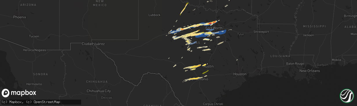
Hail Map in Texas on April 1, 2024
The weather event in Texas on April 1, 2024 includes Hail, Wind, and Tornado maps. 13 states and 893 cities were impacted and suffered possible damage. The total estimated number of properties impacted is 261,917.
Want more than just the map?
Turn this storm into a full workflow.
- Owner + property data so you know who to knock
- OnDemand branded weather history reports to win the "did we even have hail?" argument
- RoofTrace estimate so reps stop guessing numbers at the door
Bought this map? Upgrade within 7 days and we'll credit the $230. (10-15 min setup call)
Hail
Wind
Tornado
261,917
Estimated number of impacted properties by a 1.00" hail or larger95,558
Estimated number of impacted properties by a 1.75" hail or larger17,959
Estimated number of impacted properties by a 2.50" hail or largerStorm reports in Texas
Texas
| Date | Description |
|---|---|
| 04/01/20246:59 PM CDT | Report from mping: tennis ball |
| 04/01/20246:59 PM CDT | Hen egg size hail in newark. |
| 04/01/20246:57 PM CDT | Golfball size hail reported in new fairview. |
| 04/01/20246:53 PM CDT | 2 inch measured south of boyd. |
| 04/01/20246:51 PM CDT | A local report indicates 1.75 inch wind near Boyd |
| 04/01/20246:50 PM CDT | Tennis ball size hail reported just ne of springtown. |
| 04/01/20246:50 PM CDT | Downed traffic sign and dumpster moved into the road. |
| 04/01/20246:46 PM CDT | Hen egg size hail in briar... Tx. |
| 04/01/20246:42 PM CDT | Half dollar size hail in boyd. |
| 04/01/20246:40 PM CDT | Grapefruit size hail reported 5 ne of springtown by nws employee. |
| 04/01/20246:40 PM CDT | Grapefruit size hail reported 5 ne of springtown by nws employee. At us 90 and rocky rd . |
| 04/01/20246:40 PM CDT | Report from mping: quarter |
| 04/01/20246:38 PM CDT | Report from mping: half dollar |
| 04/01/20246:36 PM CDT | Report from mping: quarter |
| 04/01/20246:35 PM CDT | Report from mping: quarter |
| 04/01/20246:34 PM CDT | Spotter report of half dollar size hail. |
| 04/01/20246:23 PM CDT | Quarter size hail reported near poolville. |
| 04/01/20246:12 PM CDT | Quarter size hail reported. |
| 04/01/20246:04 PM CDT | Half dollar size hail south of eastland. |
| 04/01/20246:03 PM CDT | A local report indicates 71 MPH wind near Bangs |
| 04/01/20245:58 PM CDT | Wind damage reported to steel framed metal building. |
| 04/01/20245:47 PM CDT | Report from mping: quarter |
| 04/01/20245:36 PM CDT | Delayed report: roof off of house... Power line down on road. |
| 04/01/20245:26 PM CDT | A local report indicates 2.00 inch wind near Cisco |
| 04/01/20245:14 PM CDT | Two inch size hail near southbend tx. |
| 04/01/20245:10 PM CDT | A local report indicates 1.00 inch wind near 8 SW Admiral |
| 04/01/20244:55 PM CDT | Shingles blown off roofs. |
| 04/01/20244:45 PM CDT | A local report indicates 1.50 inch wind near Thalia |
| 04/01/20244:30 PM CDT | A local report indicates 88 MPH wind near 3 ENE Albany |
| 04/01/20244:30 PM CDT | Reported roof blown off of house. |
| 04/01/20244:25 PM CDT | A local report indicates 1.00 inch wind near Tuscola |
| 04/01/20244:10 PM CDT | 1-inch tree limbs broken and shingles blown off. |
| 04/01/20243:59 PM CDT | Trained spotter reported baseball sized hail north of lake phantom hill on fm 600. |
| 04/01/20243:46 PM CDT | Fort chadbourne mesonet reported a 71 mph gust. |
| 04/01/20243:46 PM CDT | A local report indicates 1.00 inch wind near Hawley |
| 04/01/20243:45 PM CDT | Vehicles damaged and home windows broken. |
| 04/01/20243:15 PM CDT | Nolan co s.o. Reported multiple power poles down in the city of sweetwater. |
| 04/01/20243:10 PM CDT | Power poles reported down in the city of roscoe by the nolan county sheriffs office. |
| 04/01/20243:00 PM CDT | *delayed report* cotton storage warehouse heavily damaged by thunderstorm downburst. |
| 04/01/20242:33 AM CDT | Picture of 1 inch hail with measurement received by texas state em. |
| 03/31/202410:36 PM CDT | Large tree down via nws employee photo. |
| 03/31/202410:31 PM CDT | Report from mping quarter |
| 03/31/202410:30 PM CDT | Social media picture of hail at the intersection of blanco rd and fresno st. |
| 03/31/202410:20 PM CDT | A trained spotter reported one quarter inch hail. |
| 03/31/202410:19 PM CDT | Report of hail up to quarter size with photo via twitter at potranco and 1604. |
| 03/31/202410:19 PM CDT | Ping pong sized hail reported in leon valley from trained spotter. |
| 03/31/202410:15 PM CDT | Public report of 1 inch hail 1 mile sw of sea world. |
| 03/31/202410:13 PM CDT | Hail via twitter from public of 1 inch diameter hail 7 mi ne of castroville. |
| 03/31/202410:05 PM CDT | Cocorahs reported one to one and a quarter inch hail. |
| 03/31/202410:01 PM CDT | Picture shared on social media of 1 to 1.75 inch hail in rio medina. |
| 03/31/202410:00 PM CDT | A local report indicates 1.25 inch wind near 3 WSW Rio Medina |
| 03/31/202410:00 PM CDT | A local report indicates 1.25 inch wind near 3 E Rio Medina |
| 03/31/20249:55 PM CDT | Picture of several near ping pong ball sized hailstones relayed from the public to news media. Time estimated by radar. |
| 03/31/20249:55 PM CDT | Picture of near quarter sized hail in steiner ranch shared on social media. |
| 03/31/20249:52 PM CDT | Time estimated via radar. Hail near ping pong ball size via facebook. |
| 03/31/20249:52 PM CDT | Picture of measured hail stone relayed from the public to the news media. Time adjusted based on radar. |
| 03/31/20249:48 PM CDT | Measured picture of 1.25 inch hail shared on social media. |
| 03/31/20249:30 PM CDT | Report from mping quarter |
| 03/31/20249:25 PM CDT | 1 to 1.5 inch hail reported. |
| 03/31/20249:23 PM CDT | A local report indicates 1.25 inch wind near 2 NNE Johnson City |
| 03/31/20249:23 PM CDT | Near hen egg sized hail pictured next to an egg... Relayed from the public to the media. |
| 03/31/20249:12 PM CDT | A trained spotter reported one quarter to half dollar hail at us 90 and rocky rd |
| 03/31/20249:10 PM CDT | 1.75 inch hail reported in stonewall. |
| 03/31/20249:06 PM CDT | Hen egg size hail with photo included via facebook message. |
| 03/31/20248:56 PM CDT | 1 inch hail reported at bending oaks ranch. |
| 03/31/20248:56 PM CDT | 1 inch hail reported. |
| 03/31/20248:20 PM CDT | Sheet metal shed rolled over. Scattered tree damage occurred between alvarado and venus. |
| 03/31/20247:55 PM CDT | Scattered tree damage and a large pavilion collapsed along quail park ln. Damage is consistent with straight line winds estimated at 75 mph. |
| 03/31/20247:41 PM CDT | Quarter size hail at pecan plantation. |
| 03/31/20247:35 PM CDT | Report from mping: quarter |
| 03/31/20247:33 PM CDT | Quarter size hail in iredell. |
| 03/31/20247:32 PM CDT | Report from mping: ping pong ball |
| 03/31/20247:32 PM CDT | Report from mping: ping pong ball |
| 03/31/20247:30 PM CDT | Mature bradford pear tree snapped in half vertically. |
| 03/31/20247:27 PM CDT | Hail slightly smaller than tennis balls in corral city. |
| 03/31/20247:26 PM CDT | Quarter size hail. |
| 03/31/20247:24 PM CDT | Tennis ball size hail near northlake. |
| 03/31/20247:20 PM CDT | 3 inch size hail in justin near 156 and 407. |
| 03/31/20247:20 PM CDT | Quarter size hail near robson ranch. |
| 03/31/20247:20 PM CDT | 3 inch size hail in justin near 156 and 407. |
| 03/31/20247:03 PM CDT | Quarter size hail in aurora. |
| 03/31/20247:03 PM CDT | 1 inch hail in justin. |
| 03/31/20247:02 PM CDT | 2 inch hail in rhome. |
| 03/31/20247:00 PM CDT | Golf ball size hail west of justin. |
| 03/31/20247:00 PM CDT | 3.4 inch hail measured by caliper 8 east of rhome. |
All States Impacted by Hail Map on April 1, 2024
Cities Impacted by Hail Map on April 1, 2024
- Chapin, IL
- Concord, IL
- Jacksonville, IL
- Arenzville, IL
- Tallula, IL
- Hennessey, OK
- Perry, OK
- Red Rock, OK
- Bison, OK
- Douglas, OK
- Waukomis, OK
- Kingfisher, OK
- Dover, OK
- Crescent, OK
- Sweetwater, TX
- Covington, OK
- Colorado City, TX
- Fairmont, OK
- Loraine, TX
- Roscoe, TX
- Garber, OK
- Marland, OK
- Marshall, OK
- Orlando, OK
- Rotan, TX
- Billings, OK
- Ponca City, OK
- Burbank, OK
- Shidler, OK
- Hamlin, TX
- Lucien, OK
- Cosby, MO
- Trent, TX
- Merkel, TX
- Pawhuska, OK
- Sedan, KS
- Maryneal, TX
- Amity, MO
- King City, MO
- Union Star, MO
- Cedar Vale, KS
- Maysville, MO
- Helena, MO
- Clarksdale, MO
- Kaw City, OK
- Morrison, OK
- Hawley, TX
- Anson, TX
- Peru, KS
- Petersburg, KY
- Burlington, KY
- Chautauqua, KS
- Abilene, TX
- Aurora, IN
- Rising Sun, IN
- McFall, MO
- Blackwell, TX
- Fairfax, OK
- Sylvester, TX
- Pawnee, OK
- Lueders, TX
- Niotaze, KS
- Havana, KS
- Ralston, OK
- Albany, TX
- Aspermont, TX
- Old Glory, TX
- Bronte, TX
- Latonia, KY
- Newport, KY
- Ft Mitchell, KY
- Albany, MO
- Darlington, MO
- Wingate, TX
- New Hampton, MO
- Winters, TX
- Tuscola, TX
- Ovalo, TX
- Stanberry, MO
- Bethany, MO
- Alexandria, KY
- Melbourne, KY
- Martinsville, MO
- Seymour, TX
- Crowell, TX
- Caney, KS
- Copan, OK
- Eagleville, MO
- Morning View, KY
- Independence, KY
- Ridgeway, MO
- Blythedale, MO
- Tyro, KS
- Wann, OK
- Independence, KS
- Coffeyville, KS
- Dearing, KS
- Liberty, KS
- Breckenridge, TX
- Clyde, TX
- Lawn, TX
- Lyndon, KS
- Lebo, KS
- California, KY
- New Richmond, OH
- Vassar, KS
- Overbrook, KS
- Quenemo, KS
- Butler, KY
- Vernon, TX
- Moscow, OH
- Cherryvale, KS
- Baird, TX
- Mound Valley, KS
- Edna, KS
- Cisco, TX
- Bethel, OH
- Bartlesville, OK
- Moline, KS
- Grenola, KS
- Hamersville, OH
- Goldsboro, TX
- Elk City, KS
- Felicity, OH
- Altamont, KS
- Parsons, KS
- Chillicothe, TX
- Moran, TX
- Woodson, TX
- Owensville, MO
- Foster, KY
- Dewey, OK
- Coleman, TX
- South Bend, TX
- Neville, OH
- Graham, TX
- Oswego, KS
- Graford, TX
- Strawn, TX
- Georgetown, OH
- Eastland, TX
- Hermann, MO
- Berger, MO
- New Haven, MO
- Gerald, MO
- Cross Plains, TX
- Rising Star, TX
- Barnett, MO
- Dennis, KS
- Thayer, KS
- Versailles, MO
- Caddo, TX
- Neodesha, KS
- McCune, KS
- Eldon, MO
- Russellville, MO
- Ranger, TX
- Bryson, TX
- Carbon, TX
- Marthasville, MO
- Burkett, TX
- Washington, MO
- Augusta, KY
- Eldorado, TX
- Okarche, OK
- Rich Hill, MO
- Perrin, TX
- Jacksboro, TX
- Eugene, MO
- Lohman, MO
- Olean, MO
- Jefferson City, MO
- Henley, MO
- Gorman, TX
- Mineral Wells, TX
- Augusta, MO
- Saint Thomas, MO
- Desdemona, TX
- Santa Anna, TX
- Mulhall, OK
- Guthrie, OK
- California, MO
- Leslie, MO
- Gouldbusk, TX
- Loyal, OK
- Defiance, MO
- Foristell, MO
- Weatherford, TX
- Whitt, TX
- Poolville, TX
- De Leon, TX
- Saint Charles, MO
- Westphalia, MO
- Bonnots Mill, MO
- Loose Creek, MO
- Meta, MO
- Springtown, TX
- Dublin, TX
- Mingus, TX
- Brownwood, TX
- Lamar, MO
- Stillwater, OK
- Liberal, MO
- Bangs, TX
- O'Fallon, MO
- Saint Albans, MO
- Chesterfield, MO
- Wildwood, MO
- Stephenville, TX
- Early, TX
- Jerico Springs, MO
- Sheldon, MO
- Paradise, TX
- Boyd, TX
- Linn, MO
- Gordon, TX
- Ballwin, MO
- Saint Louis, MO
- Hydro, OK
- Saint Peters, MO
- Geary, OK
- Godfrey, IL
- Alton, IL
- Hinton, OK
- Bridgeport, TX
- May, TX
- Maryland Heights, MO
- Earth City, MO
- Bridgeton, MO
- Rhome, TX
- Azle, TX
- Saint Ann, MO
- Lipan, TX
- Bluff Dale, TX
- Blanket, TX
- Hazelwood, MO
- Chamois, MO
- Zephyr, TX
- Florissant, MO
- Newark, TX
- Tolar, TX
- Granbury, TX
- Palmer, IL
- Taylorville, IL
- Carnegie, OK
- Brookesmith, TX
- Lohn, TX
- Rochelle, TX
- Watonga, OK
- Jasper, MO
- Stonington, IL
- Canute, OK
- Dill City, OK
- Foss, OK
- Decatur, TX
- Comanche, TX
- Fort Worth, TX
- Haslet, TX
- Lockwood, MO
- Stockton, MO
- Justin, TX
- Menard, TX
- Rocksprings, TX
- Sonora, TX
- Brighton, IL
- El Dorado Springs, MO
- Morrison, MO
- Moweaqua, IL
- Collins, MO
- Dover, KY
- Ripley, OH
- Perkins, OK
- Coyle, OK
- Calumet, OK
- Ripley, OK
- Glencoe, OK
- Glen Rose, TX
- Wood River, IL
- Roxana, IL
- Granite City, IL
- South Roxana, IL
- East Alton, IL
- Hartford, IL
- Denton, TX
- Argyle, TX
- Yale, OK
- Hominy, OK
- Wynona, OK
- Assumption, IL
- Bland, MO
- Fair Play, MO
- Owaneco, IL
- Arcola, MO
- Richland Springs, TX
- San Saba, TX
- Bethany, IL
- Elsah, IL
- West Alton, MO
- Portage Des Sioux, MO
- Dalton City, IL
- Mount Sterling, MO
- Humansville, MO
- Hico, TX
- Iredell, TX
- Barnsdall, OK
- Dadeville, MO
- Dunnegan, MO
- Bolivar, MO
- Polk, MO
- Godley, TX
- Cleburne, TX
- Maramec, OK
- Jennings, OK
- Cleveland, OK
- Glasgow, VA
- Buena Vista, VA
- Natural Bridge, VA
- Lexington, VA
- Ponder, TX
- Camargo, IL
- Tuscola, IL
- Roanoke, TX
- Coalgate, OK
- Mount Hope, WV
- Warrenton, MO
- Yucca, AZ
- Montgomery City, MO
- Rainbow, TX
- Cresson, TX
- Aledo, TX
- Half Way, MO
- Louisburg, MO
- Meridian, TX
- Walnut Springs, TX
- Wright City, MO
- Joshua, TX
- Crowley, TX
- Buffalo, MO
- Ochelata, OK
- Goldthwaite, TX
- Wardville, OK
- Mcalester, OK
- Stuart, OK
- Villa Grove, IL
- Weaubleau, MO
- Gravois Mills, MO
- Monroe, VA
- Morgan, TX
- Nemo, TX
- Windyville, MO
- Tunas, MO
- Osage, OK
- Keene, TX
- Burleson, TX
- Alvarado, TX
- Ramona, OK
- Wentzville, MO
- Prue, OK
- Slab Fork, WV
- Lake Ozark, MO
- Hermitage, MO
- Preston, MO
- Vesuvius, VA
- Amherst, VA
- Camdenton, MO
- Rocky Mount, MO
- Sunrise Beach, MO
- Evant, TX
- Star, TX
- Roseland, VA
- Nowata, OK
- Delaware, OK
- Oak Hill, WV
- Venus, TX
- Grandview, TX
- Skiatook, OK
- Lenapah, OK
- Midlothian, TX
- Climax Springs, MO
- Tuscumbia, MO
- Rhodell, WV
- Coal City, WV
- Josephine, WV
- Princewick, WV
- Lake Saint Louis, MO
- Rio Vista, TX
- Greencastle, IN
- Arrington, VA
- Wheatland, MO
- Quincy, MO
- Mountain Home, TX
- Hamilton, TX
- Savanna, OK
- Little Elm, TX
- Aubrey, TX
- Kaiser, MO
- Osage Beach, MO
- Ingram, TX
- Talala, OK
- Waxahachie, TX
- Vinita, OK
- Chelsea, OK
- S Coffeyville, OK
- Welch, OK
- Bainbridge, IN
- Coatesville, IN
- Harper, TX
- Gatesville, TX
- Purmela, TX
- Jonesboro, TX
- Macks Creek, MO
- Clifton, TX
- Centertown, MO
- Lampasas, TX
- Lometa, TX
- Fredericksburg, TX
- Prosper, TX
- Bluejacket, OK
- Ennis, TX
- Palmer, TX
- Red Oak, TX
- Fillmore, IN
- Kerrville, TX
- Danville, IN
- Holts Summit, MO
- Copperas Cove, TX
- Hunt, TX
- Electra, TX
- Girard, KS
- Itasca, TX
- Hillsboro, TX
- Milford, TX
- Columbus, KS
- Chetopa, KS
- Bartlett, KS
- Lancaster, TX
- Wilmer, TX
- Ferris, TX
- Baxter Springs, KS
- Miami, OK
- Stonewall, TX
- Hye, TX
- Johnson City, TX
- Meridian, OK
- Valley Mills, TX
- Steedman, MO
- Comfort, TX
- Italy, TX
- Tebbetts, MO
- New Bloomfield, MO
- Knippa, TX
- Iowa Park, TX
- Scurry, TX
- Crandall, TX
- Rosser, TX
- Kaufman, TX
- Seagoville, TX
- Galena, KS
- Scammon, KS
- Weir, KS
- Saint Elizabeth, MO
- Pittsburg, KS
- Sabinal, TX
- Cherokee, KS
- Brazil, IN
- Boerne, TX
- D Hanis, TX
- Picher, OK
- Quapaw, OK
- Center Point, TX
- Axtell, TX
- Elm Mott, TX
- Waco, TX
- Rhineland, MO
- Carl Junction, MO
- Webb City, MO
- Joplin, MO
- Riverton, KS
- Carterville, MO
- Oronogo, MO
- Purcell, MO
- Carthage, MO
- Alba, MO
- Jonesburg, MO
- Hondo, TX
- Duenweg, MO
- Mount Calm, TX
- Hubbard, TX
- Coolidge, TX
- Dripping Springs, TX
- Wills Point, TX
- Dawson, TX
- Austin, TX
- Spicewood, TX
- Golden City, MO
- Avilla, MO
- Reeds, MO
- Sarcoxie, MO
- Miller, MO
- La Russell, MO
- Castroville, TX
- Mico, TX
- San Antonio, TX
- Rio Medina, TX
- Diamond, MO
- Leander, TX
- Mannford, OK
- Drumright, OK
- Comanche, OK
- Duncan, OK
- Big Cabin, OK
- Foster, OK
- Terlton, OK
- Lindsay, OK
- Elmore City, OK
- Maysville, OK
- Pauls Valley, OK
- Greenfield, MO
- South Greenfield, MO
- Sand Springs, OK
- Sapulpa, OK
- Troy, MO
- Hennepin, OK
- Springer, OK
- Wellston, OK
- Ratliff City, OK
- Richland, TX
- Wortham, TX
- Jbsa Ft Sam Houston, TX
- Everton, MO
- Tulsa, OK
- Willard, MO
- Ash Grove, MO
- Belle, MO
- Afton, OK
- Paoli, OK
- Wayne, OK
- Pacific, MO
- Walnut Grove, MO
- Fairland, OK
- Aldrich, MO
- Pleasant Hope, MO
- Rosebud, MO
- Converse, TX
- Brighton, MO
- Bristow, OK
- Morrisville, MO
- Union, MO
- West Mineral, KS
- Seneca, MO
- Springfield, MO
- Eldridge, MO
- Schertz, TX
- Jbsa Randolph, TX
- Cibolo, TX
- Urbana, MO
- Labadie, MO
- Elkland, MO
- Villa Ridge, MO
- Lebanon, MO
- Marion, TX
- Fair Grove, MO
- Claremore, OK
- Long Lane, MO
- Brumley, MO
- Stoutland, MO
- Richland, MO
- Seguin, TX
- Marshfield, MO
- Eureka, MO
- Gray Summit, MO
- Crocker, MO
- McQueeney, TX
- Sullivan, MO
- Beaufort, MO
- Inola, OK
- Okmulgee, OK
- Valley Park, MO
- Fenton, MO
- Niangua, MO
- Conway, MO
- Morris, OK
- Mount Vernon, IL
- High Ridge, MO
- Saint Clair, MO
- Phillipsburg, MO
- Pryor, OK
- Chouteau, OK
- Iberia, MO
- Montreal, MO
- Ulman, MO
- Linn Creek, MO
- Keenes, IL
- Bluford, IL
- Spavinaw, OK
- Dixon, MO
- Laquey, MO
- Falcon, MO
- Waynesville, MO
- Fort Leonard Wood, MO
- East Saint Louis, IL
- Argyle, MO
- Kenefic, OK
- Durant, OK
- Caddo, OK
- Atoka, OK
- Kiowa, OK
- Newburg, MO
- Mount Vernon, MO
- Rolla, MO
- Blanco, OK
- Stotts City, MO
- Saint Robert, MO
- Devils Elbow, MO
- Duke, MO
- Edgar Springs, MO
- Cook Sta, MO
- Saint James, MO
- Cuba, MO
- Vichy, MO
- Braggs, OK
- Gore, OK
- Muskogee, OK
- Bunch, OK
- Cookson, OK
- Vian, OK
- Park Hill, OK
- Stilwell, OK
- Evansville, AR
- Natural Dam, AR
- Canehill, AR
- West Fork, AR
- Prairie Grove, AR
- Steelville, MO
- Potosi, MO
- Robinson, IL
- Winslow, AR
- Belgrade, MO
- Hutsonville, IL
- Fayetteville, AR
- Park Hills, MO
- Leadwood, MO
- Bonne Terre, MO
- French Village, MO
- Irondale, MO
- Valles Mines, MO
- Bismarck, MO
- Elkins, AR
- East Carondelet, IL
- Dupo, IL
- Collinsville, IL
- Maryville, IL
- Sainte Genevieve, MO
- Sparta, IL
- Saint Mary, MO
- Ellis Grove, IL
- Evansville, IL
- Walsh, IL
- Perryville, MO
- Chester, IL
- Steeleville, IL
- Coulterville, IL
- Bloomfield, IN
- Campbell Hill, IL
- Percy, IL
- Cutler, IL
- Martinsville, IN
- Switz City, IN
- San Marcos, TX
- Franklin, IN
- Morgantown, IN
- Nashville, IL
- Solsberry, IN
- Pinckneyville, IL
- Odd, WV
- Huntsville, TX
- Beckley, WV
- Bargersville, IN
- Huntsville, AR
- New Braunfels, TX
- Maxwell, TX
- Lockhart, TX
- Kyle, TX
- Tamaroa, IL
- Scheller, IL
- Iuka, IL
- Xenia, IL
- Sesser, IL
- Du Quoin, IL
- Johnsonville, IL
- Kingston, AR
- Ponca, AR
- Columbia, IL
- Compton, AR
- Opdyke, IL
- Belle Rive, IL
- Bonnie, IL
- Milroy, IN
- Rushville, IN
- Bloomsdale, MO
- Prairie Du Rocher, IL
- Jasper, AR
- Dahlgren, IL
- Wayne City, IL
- Mineral Point, MO
- Cadet, MO
- House Springs, MO
- Kingsbury, TX
- Fairfield, IL
- Cisne, IL
- Modoc, IL
- Sims, IL
- Oakdale, IL
- Glenwood, IN
- Connersville, IN
- Laurel, IN
- Chaffee, MO
- Mount Erie, IL
- Liberty, IN
- Metamora, IN
- Brookville, IN
- Albion, IL
- Ellery, IL
- Golden Gate, IL
- Bone Gap, IL
- West Salem, IL
- Waltonville, IL
- Mount Carmel, IL
- West College Corner, IN
- Lyons, IN
- Tamms, IL
- Jonesboro, IL
- Thebes, IL
- McClure, IL
- Allendale, IL
- Ullin, IL
- Dongola, IL
- Raleigh, IL
- Eldorado, IL
- Harrisburg, IL
- Omaha, IL
- Norris City, IL
- New Haven, IL
- Carmi, IL
- Mount Vernon, IN
- Equality, IL
- Junction, IL
- Ridgway, IL
- Shawneetown, IL
- Round Mountain, TX
- Poseyville, IN
- Fort Branch, IN
- Cynthiana, IN
- Haubstadt, IN
- Wadesville, IN
- Evansville, IN
- Chandler, IN
- Elberfeld, IN
- Newburgh, IN
- Lynnville, IN
- Boonville, IN
- Tennyson, IN
- Oakland City, IN
- Haynesville, LA
- Shongaloo, LA
- Gentryville, IN
- Chrisney, IN
- Rockport, IN
- Richland, IN
- Grandview, IN
- Lincoln City, IN
- Lamar, IN
- Holland, IN
- Dale, IN
- Santa Claus, IN
- Ferdinand, IN
- Evanston, IN
- Saint Meinrad, IN
- Warren, AR
- Banks, AR
- Emerson, AR
- English, IN
- Bristow, IN
- Saint Croix, IN
- Birdseye, IN
- Troy, IN
- Lewisport, KY
- Tell City, IN
- Hawesville, KY
- New Edinburg, AR
- Sulphur, IN
- Grantsburg, IN
- Whitewater, MO
- Jackson, MO
- Cape Girardeau, MO
- Marble Hill, MO
- Burfordville, MO
- Daisy, MO
- Friedheim, MO
- Oak Ridge, MO
- Millersville, MO
- Sedgewickville, MO
- Leopold, MO
- Marquand, MO
- Patton, MO
- Glenallen, MO
- Fredericktown, MO
- Greenville, MO
- Zalma, MO
- Miller City, IL
- Charleston, MO
- Cairo, IL
- Oran, MO
- Advance, MO
- Scott City, MO
- Sikeston, MO
- Benton, MO
- Olive Branch, IL
- Olmsted, IL
- Mounds, IL
- Grand Chain, IL
- Pulaski, IL
- Pomona, IL
- Old Appleton, MO
- Anna, IL
- Carbondale, IL
- Cypress, IL
- Frohna, MO
- Altenburg, MO
- Mound City, IL
- Alto Pass, IL
- Goreville, IL
- Buncombe, IL
- Jacob, IL
- Villa Ridge, IL
- Barlow, KY
- Marion, IL
- Grand Tower, IL
- Cobden, IL
- Murphysboro, IL
- Uniontown, MO
- Gorham, IL
- Wolf Lake, IL
- Makanda, IL
- Farrar, MO
- Carterville, IL
- New Burnside, IL
- Ozark, IL
- Galatia, IL
- Stonefort, IL
- Belknap, IL
- Kevil, KY
- La Center, KY
- Carrier Mills, IL
- Vienna, IL
- Karnak, IL
- Creal Springs, IL
- Simpson, IL
- Marion, KY
- Golconda, IL
- Grantsburg, IL
- Metropolis, IL
- Elizabethtown, IL
- Rosiclare, IL
- Salem, KY
- West Paducah, KY
- Eddyville, IL
- Herod, IL
- Wickliffe, KY
- Hampton, KY
- Smithland, KY
- Paducah, KY
- Brookport, IL
- Burna, KY
- Cave In Rock, IL
- De Mossville, KY
- Bloomington, IN
- Farmington, MO
- Bath, IN
- Trafalgar, IN
- Nineveh, IN
- Manilla, IN
- Festus, MO
- Waldron, IN
- Shelbyville, IN
- Bourbon, MO
- Garfield, AR
- Grovespring, MO
- Morganfield, KY
- Uniontown, KY
- Waverly, KY
- New Harmony, IN
- Sturgis, KY


