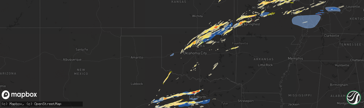
Hail Map in Oklahoma on April 1, 2024
The weather event in Oklahoma on April 1, 2024 includes Hail, Wind, and Tornado maps. 13 states and 893 cities were impacted and suffered possible damage. The total estimated number of properties impacted is 18,254.
Want more than just the map?
Turn this storm into a full workflow.
- Owner + property data so you know who to knock
- OnDemand branded weather history reports to win the "did we even have hail?" argument
- RoofTrace estimate so reps stop guessing numbers at the door
Bought this map? Upgrade within 7 days and we'll credit the $230. (10-15 min setup call)
Hail
Wind
Tornado
18,254
Estimated number of impacted properties by a 1.00" hail or larger1,975
Estimated number of impacted properties by a 1.75" hail or larger376
Estimated number of impacted properties by a 2.50" hail or largerStorm reports in Oklahoma
Oklahoma
| Date | Description |
|---|---|
| 04/01/20246:28 PM CDT | Clinton-sherman asos. |
| 04/01/20244:30 PM CDT | Report of damage from strong thunderstorm winds west of hulah. |
| 04/01/20242:58 PM CDT | Video of 2 inch diameter hail. |
| 04/01/20241:55 PM CDT | A local report indicates 1.00 inch wind near Hennessey |
| 04/01/202412:57 AM CDT | Tree limb across road near lyons switch. |
| 03/31/20249:13 PM CDT | Report from mping: quarter |
| 03/31/20248:15 PM CDT | Rolled semi with 1 trapped occupant. |
| 03/31/20248:07 PM CDT | Public reported a tornado on the ground southeast of hominy. |
| 03/31/20247:53 PM CDT | Tornado crossing highway 75. |
| 03/31/20247:38 PM CDT | A tornado damaged homes... Destroyed outbuildings... And blew down trees and power poles. |
| 03/31/20247:30 PM CDT | Report of tree damage 1 mile north of the dick conner correctional center north of hominy. Possible tornado. |
| 03/31/20247:30 PM CDT | Report from mping: quarter |
| 03/31/20247:30 PM CDT | Report of tree damage 1 mile north of the dick conner correctional center north of hominy. Possi |
| 03/31/20247:30 PM CDT | Report from mping: quarter |
| 03/31/20247:30 PM CDT | Report from mping: quarter |
| 03/31/20247:29 PM CDT | A tornado removed the roof from a two-car garage... Uprooted or snapped numerous trees... And snapped power poles. |
| 03/31/20247:18 PM CDT | Corrects previous tornado report from 4 n hominy. Nws survey crew found ef1 damage from sw of wynona to e of wynona. Survey still ongoing and will be refined. |
All States Impacted by Hail Map on April 1, 2024
Cities Impacted by Hail Map on April 1, 2024
- Chapin, IL
- Concord, IL
- Jacksonville, IL
- Arenzville, IL
- Tallula, IL
- Hennessey, OK
- Perry, OK
- Red Rock, OK
- Bison, OK
- Douglas, OK
- Waukomis, OK
- Kingfisher, OK
- Dover, OK
- Crescent, OK
- Sweetwater, TX
- Covington, OK
- Colorado City, TX
- Fairmont, OK
- Loraine, TX
- Roscoe, TX
- Garber, OK
- Marland, OK
- Marshall, OK
- Orlando, OK
- Rotan, TX
- Billings, OK
- Ponca City, OK
- Burbank, OK
- Shidler, OK
- Hamlin, TX
- Lucien, OK
- Cosby, MO
- Trent, TX
- Merkel, TX
- Pawhuska, OK
- Sedan, KS
- Maryneal, TX
- Amity, MO
- King City, MO
- Union Star, MO
- Cedar Vale, KS
- Maysville, MO
- Helena, MO
- Clarksdale, MO
- Kaw City, OK
- Morrison, OK
- Hawley, TX
- Anson, TX
- Peru, KS
- Petersburg, KY
- Burlington, KY
- Chautauqua, KS
- Abilene, TX
- Aurora, IN
- Rising Sun, IN
- McFall, MO
- Blackwell, TX
- Fairfax, OK
- Sylvester, TX
- Pawnee, OK
- Lueders, TX
- Niotaze, KS
- Havana, KS
- Ralston, OK
- Albany, TX
- Aspermont, TX
- Old Glory, TX
- Bronte, TX
- Latonia, KY
- Newport, KY
- Ft Mitchell, KY
- Albany, MO
- Darlington, MO
- Wingate, TX
- New Hampton, MO
- Winters, TX
- Tuscola, TX
- Ovalo, TX
- Stanberry, MO
- Bethany, MO
- Alexandria, KY
- Melbourne, KY
- Martinsville, MO
- Seymour, TX
- Crowell, TX
- Caney, KS
- Copan, OK
- Eagleville, MO
- Morning View, KY
- Independence, KY
- Ridgeway, MO
- Blythedale, MO
- Tyro, KS
- Wann, OK
- Independence, KS
- Coffeyville, KS
- Dearing, KS
- Liberty, KS
- Breckenridge, TX
- Clyde, TX
- Lawn, TX
- Lyndon, KS
- Lebo, KS
- California, KY
- New Richmond, OH
- Vassar, KS
- Overbrook, KS
- Quenemo, KS
- Butler, KY
- Vernon, TX
- Moscow, OH
- Cherryvale, KS
- Baird, TX
- Mound Valley, KS
- Edna, KS
- Cisco, TX
- Bethel, OH
- Bartlesville, OK
- Moline, KS
- Grenola, KS
- Hamersville, OH
- Goldsboro, TX
- Elk City, KS
- Felicity, OH
- Altamont, KS
- Parsons, KS
- Chillicothe, TX
- Moran, TX
- Woodson, TX
- Owensville, MO
- Foster, KY
- Dewey, OK
- Coleman, TX
- South Bend, TX
- Neville, OH
- Graham, TX
- Oswego, KS
- Graford, TX
- Strawn, TX
- Georgetown, OH
- Eastland, TX
- Hermann, MO
- Berger, MO
- New Haven, MO
- Gerald, MO
- Cross Plains, TX
- Rising Star, TX
- Barnett, MO
- Dennis, KS
- Thayer, KS
- Versailles, MO
- Caddo, TX
- Neodesha, KS
- McCune, KS
- Eldon, MO
- Russellville, MO
- Ranger, TX
- Bryson, TX
- Carbon, TX
- Marthasville, MO
- Burkett, TX
- Washington, MO
- Augusta, KY
- Eldorado, TX
- Okarche, OK
- Rich Hill, MO
- Perrin, TX
- Jacksboro, TX
- Eugene, MO
- Lohman, MO
- Olean, MO
- Jefferson City, MO
- Henley, MO
- Gorman, TX
- Mineral Wells, TX
- Augusta, MO
- Saint Thomas, MO
- Desdemona, TX
- Santa Anna, TX
- Mulhall, OK
- Guthrie, OK
- California, MO
- Leslie, MO
- Gouldbusk, TX
- Loyal, OK
- Defiance, MO
- Foristell, MO
- Weatherford, TX
- Whitt, TX
- Poolville, TX
- De Leon, TX
- Saint Charles, MO
- Westphalia, MO
- Bonnots Mill, MO
- Loose Creek, MO
- Meta, MO
- Springtown, TX
- Dublin, TX
- Mingus, TX
- Brownwood, TX
- Lamar, MO
- Stillwater, OK
- Liberal, MO
- Bangs, TX
- O'Fallon, MO
- Saint Albans, MO
- Chesterfield, MO
- Wildwood, MO
- Stephenville, TX
- Early, TX
- Jerico Springs, MO
- Sheldon, MO
- Paradise, TX
- Boyd, TX
- Linn, MO
- Gordon, TX
- Ballwin, MO
- Saint Louis, MO
- Hydro, OK
- Saint Peters, MO
- Geary, OK
- Godfrey, IL
- Alton, IL
- Hinton, OK
- Bridgeport, TX
- May, TX
- Maryland Heights, MO
- Earth City, MO
- Bridgeton, MO
- Rhome, TX
- Azle, TX
- Saint Ann, MO
- Lipan, TX
- Bluff Dale, TX
- Blanket, TX
- Hazelwood, MO
- Chamois, MO
- Zephyr, TX
- Florissant, MO
- Newark, TX
- Tolar, TX
- Granbury, TX
- Palmer, IL
- Taylorville, IL
- Carnegie, OK
- Brookesmith, TX
- Lohn, TX
- Rochelle, TX
- Watonga, OK
- Jasper, MO
- Stonington, IL
- Canute, OK
- Dill City, OK
- Foss, OK
- Decatur, TX
- Comanche, TX
- Fort Worth, TX
- Haslet, TX
- Lockwood, MO
- Stockton, MO
- Justin, TX
- Menard, TX
- Rocksprings, TX
- Sonora, TX
- Brighton, IL
- El Dorado Springs, MO
- Morrison, MO
- Moweaqua, IL
- Collins, MO
- Dover, KY
- Ripley, OH
- Perkins, OK
- Coyle, OK
- Calumet, OK
- Ripley, OK
- Glencoe, OK
- Glen Rose, TX
- Wood River, IL
- Roxana, IL
- Granite City, IL
- South Roxana, IL
- East Alton, IL
- Hartford, IL
- Denton, TX
- Argyle, TX
- Yale, OK
- Hominy, OK
- Wynona, OK
- Assumption, IL
- Bland, MO
- Fair Play, MO
- Owaneco, IL
- Arcola, MO
- Richland Springs, TX
- San Saba, TX
- Bethany, IL
- Elsah, IL
- West Alton, MO
- Portage Des Sioux, MO
- Dalton City, IL
- Mount Sterling, MO
- Humansville, MO
- Hico, TX
- Iredell, TX
- Barnsdall, OK
- Dadeville, MO
- Dunnegan, MO
- Bolivar, MO
- Polk, MO
- Godley, TX
- Cleburne, TX
- Maramec, OK
- Jennings, OK
- Cleveland, OK
- Glasgow, VA
- Buena Vista, VA
- Natural Bridge, VA
- Lexington, VA
- Ponder, TX
- Camargo, IL
- Tuscola, IL
- Roanoke, TX
- Coalgate, OK
- Mount Hope, WV
- Warrenton, MO
- Yucca, AZ
- Montgomery City, MO
- Rainbow, TX
- Cresson, TX
- Aledo, TX
- Half Way, MO
- Louisburg, MO
- Meridian, TX
- Walnut Springs, TX
- Wright City, MO
- Joshua, TX
- Crowley, TX
- Buffalo, MO
- Ochelata, OK
- Goldthwaite, TX
- Wardville, OK
- Mcalester, OK
- Stuart, OK
- Villa Grove, IL
- Weaubleau, MO
- Gravois Mills, MO
- Monroe, VA
- Morgan, TX
- Nemo, TX
- Windyville, MO
- Tunas, MO
- Osage, OK
- Keene, TX
- Burleson, TX
- Alvarado, TX
- Ramona, OK
- Wentzville, MO
- Prue, OK
- Slab Fork, WV
- Lake Ozark, MO
- Hermitage, MO
- Preston, MO
- Vesuvius, VA
- Amherst, VA
- Camdenton, MO
- Rocky Mount, MO
- Sunrise Beach, MO
- Evant, TX
- Star, TX
- Roseland, VA
- Nowata, OK
- Delaware, OK
- Oak Hill, WV
- Venus, TX
- Grandview, TX
- Skiatook, OK
- Lenapah, OK
- Midlothian, TX
- Climax Springs, MO
- Tuscumbia, MO
- Rhodell, WV
- Coal City, WV
- Josephine, WV
- Princewick, WV
- Lake Saint Louis, MO
- Rio Vista, TX
- Greencastle, IN
- Arrington, VA
- Wheatland, MO
- Quincy, MO
- Mountain Home, TX
- Hamilton, TX
- Savanna, OK
- Little Elm, TX
- Aubrey, TX
- Kaiser, MO
- Osage Beach, MO
- Ingram, TX
- Talala, OK
- Waxahachie, TX
- Vinita, OK
- Chelsea, OK
- S Coffeyville, OK
- Welch, OK
- Bainbridge, IN
- Coatesville, IN
- Harper, TX
- Gatesville, TX
- Purmela, TX
- Jonesboro, TX
- Macks Creek, MO
- Clifton, TX
- Centertown, MO
- Lampasas, TX
- Lometa, TX
- Fredericksburg, TX
- Prosper, TX
- Bluejacket, OK
- Ennis, TX
- Palmer, TX
- Red Oak, TX
- Fillmore, IN
- Kerrville, TX
- Danville, IN
- Holts Summit, MO
- Copperas Cove, TX
- Hunt, TX
- Electra, TX
- Girard, KS
- Itasca, TX
- Hillsboro, TX
- Milford, TX
- Columbus, KS
- Chetopa, KS
- Bartlett, KS
- Lancaster, TX
- Wilmer, TX
- Ferris, TX
- Baxter Springs, KS
- Miami, OK
- Stonewall, TX
- Hye, TX
- Johnson City, TX
- Meridian, OK
- Valley Mills, TX
- Steedman, MO
- Comfort, TX
- Italy, TX
- Tebbetts, MO
- New Bloomfield, MO
- Knippa, TX
- Iowa Park, TX
- Scurry, TX
- Crandall, TX
- Rosser, TX
- Kaufman, TX
- Seagoville, TX
- Galena, KS
- Scammon, KS
- Weir, KS
- Saint Elizabeth, MO
- Pittsburg, KS
- Sabinal, TX
- Cherokee, KS
- Brazil, IN
- Boerne, TX
- D Hanis, TX
- Picher, OK
- Quapaw, OK
- Center Point, TX
- Axtell, TX
- Elm Mott, TX
- Waco, TX
- Rhineland, MO
- Carl Junction, MO
- Webb City, MO
- Joplin, MO
- Riverton, KS
- Carterville, MO
- Oronogo, MO
- Purcell, MO
- Carthage, MO
- Alba, MO
- Jonesburg, MO
- Hondo, TX
- Duenweg, MO
- Mount Calm, TX
- Hubbard, TX
- Coolidge, TX
- Dripping Springs, TX
- Wills Point, TX
- Dawson, TX
- Austin, TX
- Spicewood, TX
- Golden City, MO
- Avilla, MO
- Reeds, MO
- Sarcoxie, MO
- Miller, MO
- La Russell, MO
- Castroville, TX
- Mico, TX
- San Antonio, TX
- Rio Medina, TX
- Diamond, MO
- Leander, TX
- Mannford, OK
- Drumright, OK
- Comanche, OK
- Duncan, OK
- Big Cabin, OK
- Foster, OK
- Terlton, OK
- Lindsay, OK
- Elmore City, OK
- Maysville, OK
- Pauls Valley, OK
- Greenfield, MO
- South Greenfield, MO
- Sand Springs, OK
- Sapulpa, OK
- Troy, MO
- Hennepin, OK
- Springer, OK
- Wellston, OK
- Ratliff City, OK
- Richland, TX
- Wortham, TX
- Jbsa Ft Sam Houston, TX
- Everton, MO
- Tulsa, OK
- Willard, MO
- Ash Grove, MO
- Belle, MO
- Afton, OK
- Paoli, OK
- Wayne, OK
- Pacific, MO
- Walnut Grove, MO
- Fairland, OK
- Aldrich, MO
- Pleasant Hope, MO
- Rosebud, MO
- Converse, TX
- Brighton, MO
- Bristow, OK
- Morrisville, MO
- Union, MO
- West Mineral, KS
- Seneca, MO
- Springfield, MO
- Eldridge, MO
- Schertz, TX
- Jbsa Randolph, TX
- Cibolo, TX
- Urbana, MO
- Labadie, MO
- Elkland, MO
- Villa Ridge, MO
- Lebanon, MO
- Marion, TX
- Fair Grove, MO
- Claremore, OK
- Long Lane, MO
- Brumley, MO
- Stoutland, MO
- Richland, MO
- Seguin, TX
- Marshfield, MO
- Eureka, MO
- Gray Summit, MO
- Crocker, MO
- McQueeney, TX
- Sullivan, MO
- Beaufort, MO
- Inola, OK
- Okmulgee, OK
- Valley Park, MO
- Fenton, MO
- Niangua, MO
- Conway, MO
- Morris, OK
- Mount Vernon, IL
- High Ridge, MO
- Saint Clair, MO
- Phillipsburg, MO
- Pryor, OK
- Chouteau, OK
- Iberia, MO
- Montreal, MO
- Ulman, MO
- Linn Creek, MO
- Keenes, IL
- Bluford, IL
- Spavinaw, OK
- Dixon, MO
- Laquey, MO
- Falcon, MO
- Waynesville, MO
- Fort Leonard Wood, MO
- East Saint Louis, IL
- Argyle, MO
- Kenefic, OK
- Durant, OK
- Caddo, OK
- Atoka, OK
- Kiowa, OK
- Newburg, MO
- Mount Vernon, MO
- Rolla, MO
- Blanco, OK
- Stotts City, MO
- Saint Robert, MO
- Devils Elbow, MO
- Duke, MO
- Edgar Springs, MO
- Cook Sta, MO
- Saint James, MO
- Cuba, MO
- Vichy, MO
- Braggs, OK
- Gore, OK
- Muskogee, OK
- Bunch, OK
- Cookson, OK
- Vian, OK
- Park Hill, OK
- Stilwell, OK
- Evansville, AR
- Natural Dam, AR
- Canehill, AR
- West Fork, AR
- Prairie Grove, AR
- Steelville, MO
- Potosi, MO
- Robinson, IL
- Winslow, AR
- Belgrade, MO
- Hutsonville, IL
- Fayetteville, AR
- Park Hills, MO
- Leadwood, MO
- Bonne Terre, MO
- French Village, MO
- Irondale, MO
- Valles Mines, MO
- Bismarck, MO
- Elkins, AR
- East Carondelet, IL
- Dupo, IL
- Collinsville, IL
- Maryville, IL
- Sainte Genevieve, MO
- Sparta, IL
- Saint Mary, MO
- Ellis Grove, IL
- Evansville, IL
- Walsh, IL
- Perryville, MO
- Chester, IL
- Steeleville, IL
- Coulterville, IL
- Bloomfield, IN
- Campbell Hill, IL
- Percy, IL
- Cutler, IL
- Martinsville, IN
- Switz City, IN
- San Marcos, TX
- Franklin, IN
- Morgantown, IN
- Nashville, IL
- Solsberry, IN
- Pinckneyville, IL
- Odd, WV
- Huntsville, TX
- Beckley, WV
- Bargersville, IN
- Huntsville, AR
- New Braunfels, TX
- Maxwell, TX
- Lockhart, TX
- Kyle, TX
- Tamaroa, IL
- Scheller, IL
- Iuka, IL
- Xenia, IL
- Sesser, IL
- Du Quoin, IL
- Johnsonville, IL
- Kingston, AR
- Ponca, AR
- Columbia, IL
- Compton, AR
- Opdyke, IL
- Belle Rive, IL
- Bonnie, IL
- Milroy, IN
- Rushville, IN
- Bloomsdale, MO
- Prairie Du Rocher, IL
- Jasper, AR
- Dahlgren, IL
- Wayne City, IL
- Mineral Point, MO
- Cadet, MO
- House Springs, MO
- Kingsbury, TX
- Fairfield, IL
- Cisne, IL
- Modoc, IL
- Sims, IL
- Oakdale, IL
- Glenwood, IN
- Connersville, IN
- Laurel, IN
- Chaffee, MO
- Mount Erie, IL
- Liberty, IN
- Metamora, IN
- Brookville, IN
- Albion, IL
- Ellery, IL
- Golden Gate, IL
- Bone Gap, IL
- West Salem, IL
- Waltonville, IL
- Mount Carmel, IL
- West College Corner, IN
- Lyons, IN
- Tamms, IL
- Jonesboro, IL
- Thebes, IL
- McClure, IL
- Allendale, IL
- Ullin, IL
- Dongola, IL
- Raleigh, IL
- Eldorado, IL
- Harrisburg, IL
- Omaha, IL
- Norris City, IL
- New Haven, IL
- Carmi, IL
- Mount Vernon, IN
- Equality, IL
- Junction, IL
- Ridgway, IL
- Shawneetown, IL
- Round Mountain, TX
- Poseyville, IN
- Fort Branch, IN
- Cynthiana, IN
- Haubstadt, IN
- Wadesville, IN
- Evansville, IN
- Chandler, IN
- Elberfeld, IN
- Newburgh, IN
- Lynnville, IN
- Boonville, IN
- Tennyson, IN
- Oakland City, IN
- Haynesville, LA
- Shongaloo, LA
- Gentryville, IN
- Chrisney, IN
- Rockport, IN
- Richland, IN
- Grandview, IN
- Lincoln City, IN
- Lamar, IN
- Holland, IN
- Dale, IN
- Santa Claus, IN
- Ferdinand, IN
- Evanston, IN
- Saint Meinrad, IN
- Warren, AR
- Banks, AR
- Emerson, AR
- English, IN
- Bristow, IN
- Saint Croix, IN
- Birdseye, IN
- Troy, IN
- Lewisport, KY
- Tell City, IN
- Hawesville, KY
- New Edinburg, AR
- Sulphur, IN
- Grantsburg, IN
- Whitewater, MO
- Jackson, MO
- Cape Girardeau, MO
- Marble Hill, MO
- Burfordville, MO
- Daisy, MO
- Friedheim, MO
- Oak Ridge, MO
- Millersville, MO
- Sedgewickville, MO
- Leopold, MO
- Marquand, MO
- Patton, MO
- Glenallen, MO
- Fredericktown, MO
- Greenville, MO
- Zalma, MO
- Miller City, IL
- Charleston, MO
- Cairo, IL
- Oran, MO
- Advance, MO
- Scott City, MO
- Sikeston, MO
- Benton, MO
- Olive Branch, IL
- Olmsted, IL
- Mounds, IL
- Grand Chain, IL
- Pulaski, IL
- Pomona, IL
- Old Appleton, MO
- Anna, IL
- Carbondale, IL
- Cypress, IL
- Frohna, MO
- Altenburg, MO
- Mound City, IL
- Alto Pass, IL
- Goreville, IL
- Buncombe, IL
- Jacob, IL
- Villa Ridge, IL
- Barlow, KY
- Marion, IL
- Grand Tower, IL
- Cobden, IL
- Murphysboro, IL
- Uniontown, MO
- Gorham, IL
- Wolf Lake, IL
- Makanda, IL
- Farrar, MO
- Carterville, IL
- New Burnside, IL
- Ozark, IL
- Galatia, IL
- Stonefort, IL
- Belknap, IL
- Kevil, KY
- La Center, KY
- Carrier Mills, IL
- Vienna, IL
- Karnak, IL
- Creal Springs, IL
- Simpson, IL
- Marion, KY
- Golconda, IL
- Grantsburg, IL
- Metropolis, IL
- Elizabethtown, IL
- Rosiclare, IL
- Salem, KY
- West Paducah, KY
- Eddyville, IL
- Herod, IL
- Wickliffe, KY
- Hampton, KY
- Smithland, KY
- Paducah, KY
- Brookport, IL
- Burna, KY
- Cave In Rock, IL
- De Mossville, KY
- Bloomington, IN
- Farmington, MO
- Bath, IN
- Trafalgar, IN
- Nineveh, IN
- Manilla, IN
- Festus, MO
- Waldron, IN
- Shelbyville, IN
- Bourbon, MO
- Garfield, AR
- Grovespring, MO
- Morganfield, KY
- Uniontown, KY
- Waverly, KY
- New Harmony, IN
- Sturgis, KY


