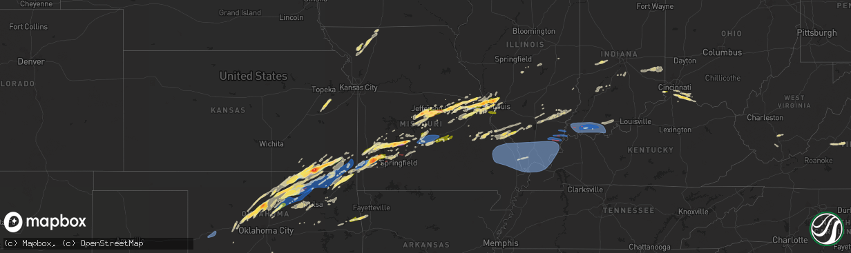
Hail Map in Missouri on April 1, 2024
The weather event in Missouri on April 1, 2024 includes Hail, Wind, and Tornado maps. 13 states and 893 cities were impacted and suffered possible damage. The total estimated number of properties impacted is 191,367.
Want more than just the map?
Turn this storm into a full workflow.
- Owner + property data so you know who to knock
- OnDemand branded weather history reports to win the "did we even have hail?" argument
- RoofTrace estimate so reps stop guessing numbers at the door
Bought this map? Upgrade within 7 days and we'll credit the $230. (10-15 min setup call)
Hail
Wind
Tornado
191,367
Estimated number of impacted properties by a 1.00" hail or larger91,855
Estimated number of impacted properties by a 1.75" hail or larger3,651
Estimated number of impacted properties by a 2.50" hail or largerStorm reports in Missouri
Missouri
| Date | Description |
|---|---|
| 04/01/20246:59 PM CDT | Unsure on the true size of the stones... But was confident they were larger than quarters. |
| 04/01/20246:58 PM CDT | Quarter sized hail reported at location. |
| 04/01/20246:57 PM CDT | Estimated ping pong ball sized hail from emailed photo. |
| 04/01/20246:56 PM CDT | A local report indicates 1.50 inch wind near Ferguson |
| 04/01/20246:56 PM CDT | Reported ping pong ball sized hail in florissant. Via facebook. |
| 04/01/20246:56 PM CDT | Spotter measured 2 inch hail at his home. |
| 04/01/20246:55 PM CDT | Picture of golf ball sized hail in ferguson estimated compared to penny in hand. |
| 04/01/20246:54 PM CDT | Via social media picture on x. Large tree down over the road. |
| 04/01/20246:54 PM CDT | Numerous reports of quarter sized hail in hazelwood. |
| 04/01/20246:54 PM CDT | Numerous reports of quarter sized hail in hazelwood. |
| 04/01/20246:53 PM CDT | Quarter sized hail. |
| 04/01/20246:53 PM CDT | 1.5 inch hail reported in pershing. |
| 04/01/20246:51 PM CDT | Via twitter... Estimated quarter sized hail from video. |
| 04/01/20246:51 PM CDT | A local report indicates 1.00 inch wind near 1 NE Hazelwood |
| 04/01/20246:51 PM CDT | Via twitter with picture. Hail slightly larger than quarter. |
| 04/01/20246:48 PM CDT | Strong winds came through for 3-5 minutes and took over a 12 to 14 inch tree. |
| 04/01/20246:48 PM CDT | Strong winds came through for 3-5 minutes and took over a 12 to 14 inch tree. |
| 04/01/20246:46 PM CDT | Spotter reports 3 inch limbs down with estimated 40 to 50 mph winds. |
| 04/01/20246:46 PM CDT | Missouri state highway patrol reports an unknown object blocking all westbound lanes and a portion of the eastbound lanes on rte z. Its not confirmed if its a tree... T |
| 04/01/20246:42 PM CDT | Quarter sized hail near family arena. |
| 04/01/20246:41 PM CDT | Estimated from picture of large hail covering the ground. |
| 04/01/20246:40 PM CDT | Picture on twitter of measurement. Quarter sized hail. |
| 04/01/20246:36 PM CDT | Uprooted tree. No picture. |
| 04/01/20246:36 PM CDT | Fallen light pole... A few shingles missing from roof... Light tree damage... And fallen sign. All pictures from twitter. |
| 04/01/20246:32 PM CDT | An nws storm survey team found that an ef0 tornado occurred yesterday april 1 in chesterfield. The tornado was on the ground for 2 miles... Had a max path width of 332 |
| 04/01/20246:29 PM CDT | Quarter sized hail at location. |
| 04/01/20246:28 PM CDT | Copious amounts of quarter to golf ball sized hail fallen in russellville. Via a picture sent from sgf shared by local broadcast media. |
| 04/01/20246:27 PM CDT | Spotter reported quarter sized hail. |
| 04/01/20246:27 PM CDT | A local report indicates 61 MPH wind near 4 S Weldon Spring |
| 04/01/20246:27 PM CDT | Trees down in westphalia - report from sgf from miller county 911 center. |
| 04/01/20246:26 PM CDT | One large tree snapped at base and branches splintered. The health of the tree isnt clear. |
| 04/01/20246:26 PM CDT | Downed tree branches varying in size... Most small one large. Sagging power lines as a result. |
| 04/01/20246:25 PM CDT | Spotter reported quarter sized hail. |
| 04/01/20246:25 PM CDT | A local report indicates 1.00 inch wind near 1 NW Linn |
| 04/01/20246:24 PM CDT | A local report indicates 1.00 inch wind near 3 W Wildwood |
| 04/01/20246:21 PM CDT | Numerous reports of heavy golf ball sized hail falling in chesterfield for at least 5 minutes. |
| 04/01/20246:20 PM CDT | Damage to multiple large trees including uprooting and snapping at base and trunk. |
| 04/01/20246:20 PM CDT | Corrects previous tstm wnd dmg report from 3 e chesterfield. From news broadcast: large uprooted tree... Tree branches piercing roof in a home. Numerous branches down i |
| 04/01/20246:20 PM CDT | Media broadcast of tree damage on appalachian trail. |
| 04/01/20246:11 PM CDT | Several golf ball sized hailstones in wardsville... With lots more small hail. Via twitter with picture. |
| 04/01/20246:11 PM CDT | Several golf ball sized hailstones in wardsville... With lots more small hail. Via twitter with picture. |
| 04/01/20246:11 PM CDT | Golf balls at wardsville. |
| 04/01/20246:09 PM CDT | A local report indicates 1.75 inch wind near Wardsville |
| 04/01/20245:56 PM CDT | Large tree uprooted. Health of tree is unclear. |
| 04/01/20245:55 PM CDT | Spotter reported estimated quarter sized hail at location. |
| 04/01/20245:55 PM CDT | Multiple trees and branches down on west end of washington. Branches between 6 and 12 inches. |
| 04/01/20245:50 PM CDT | A local report indicates 72 MPH wind near 1 SSW Dutzow |
| 04/01/20245:38 PM CDT | Photo sent in with reports from em and 911... Estimated 1.75 hail from nwschat2.0. |
| 04/01/20245:26 PM CDT | Reported via em on nwschat2.0 with photo. |
| 04/01/20243:55 PM CDT | Quarter sized hail reported in king city. Time estimated from radar. |
| 04/01/202411:44 AM CDT | Facebook photo report of large trees snapped at a residence on elliott dr. Time estimated from radar. |
| 04/01/202411:43 AM CDT | Facebook photo report of displaced shingles on roof of home and an uprooted tree. Time estimated by radar. |
| 04/01/20244:53 AM CDT | Asos station kcgi cape girardeau mo. |
| 04/01/20244:24 AM CDT | Large grain bin destroyed. Relayed via facebook. |
| 04/01/20244:20 AM CDT | A couple large trees down. |
| 04/01/20244:20 AM CDT | Roof damage to a house on highland drive. |
| 04/01/20244:17 AM CDT | Trees down on powerlines. |
| 04/01/20244:15 AM CDT | Damage to a barn. |
| 04/01/20242:01 AM CDT | Report from mping: quarter |
| 04/01/20241:55 AM CDT | Quarter sized hail in oakville. |
| 04/01/20241:55 AM CDT | Mping report of quarter sized hail. |
| 04/01/20241:55 AM CDT | Report from mping: quarter |
| 04/01/20241:34 AM CDT | Spotter reported trees down along hwy k. Trees that arent down have been stripped of leaves. Home damage nearby on stormy lane. |
| 04/01/20241:30 AM CDT | Facebook photo report of several tree limbs down. |
| 04/01/20241:15 AM CDT | Corrects previous tstm wnd dmg report from blue eye. Metal outbuildings destroyed and damage home siding. Time estimated from radar. |
| 04/01/20241:15 AM CDT | Metal outbuildings destroyed and damage home siding. Time estimated from radar. |
| 04/01/20241:03 AM CDT | Metal from structures twisted... Large trees and poles down... Twisted metal form structure lodged in tree... Barn damage to siding. Time estimated from radar. |
| 04/01/202412:31 AM CDT | Report from mping: quarter |
| 04/01/202412:30 AM CDT | Mping report of quarter sized hail in cuba. |
| 04/01/202412:27 AM CDT | Updates tornado report from saint james. A brief and weak ef-0 tornado damaged small outbuildings at an elementary school before causing damage to a light pole at the f |
| 04/01/202412:27 AM CDT | Nws storm survey found that a brief and weak ef 0 tornado damaged small outbuildings at an elementary school before causing damage to a light pole at the football stadi |
| 04/01/202412:18 AM CDT | Nws storm survey found that 80 mph straight line winds caused damage to outbuildings in southeast maries county. |
| 04/01/202412:18 AM CDT | Report from mping: 3-inch tree limbs broken; power poles broken. |
| 04/01/202412:16 AM CDT | Report from mping: trees uprooted or snapped; roof blown off. |
| 04/01/202412:12 AM CDT | Report from mping: trees uprooted or snapped; roof blown off. |
| 04/01/202412:05 AM CDT | Photo via email from phelps county... Just north of i44 near mile marker 169 of large trees completely uprooted and others are snapped and tops twisted out. Diameters r |
| 03/31/202411:59 PM CDT | Facebook report with photo of chicken coops turned over and a barn with roof torn off of it. Time estimated by radar. |
| 03/31/202411:59 PM CDT | Facebook report with photo of chicken coops turned over and a barn with roof torn off of it. Time estimated by radar. |
| 03/31/202411:58 PM CDT | Delayed report. Porch ripped off... Metal buildings destroyed... And large trees uprooted and branches removed on state route p just east of route j. |
| 03/31/202411:58 PM CDT | Delayed report. Porch ripped off... Metal buildings destroyed... And large trees uprooted and branches removed on state route p just east of route j. |
| 03/31/202411:55 PM CDT | Photos via media in nwschat2.0. Ed morse ford in st. Robert with damage of metal stick embedded in a wall... And ceiling tiles blown out of a structure. Time estimated |
| 03/31/202411:51 PM CDT | Facebook photo report tree stripped of bark and multiple limbs displaced... With part of the tree broken off and onto the roof of a home. Sunset village hwy z saint rob |
| 03/31/202411:51 PM CDT | Facebook photo report tree stripped of bark and multiple limbs displaced... With part of the tree broken off and onto the roof of a home. Sunset village hwy z saint rob |
| 03/31/202411:50 PM CDT | Facebook photo report of ripped billboard at road ranger truck stop off i44 exit 163. Time estimated by radar. |
| 03/31/202411:50 PM CDT | Delayed reports. Large number of tree branches and power lines down across central pulaski county. Time estimated from radar. |
| 03/31/202411:50 PM CDT | Delayed reports. Large number of tree branches and power lines down across central pulaski county. Time estimated from radar. |
| 03/31/202411:50 PM CDT | Facebook photo report of ripped billboard at road ranger truck stop off i44 exit 163. Time estimated by radar. |
| 03/31/202411:49 PM CDT | Report from mping: 1-inch tree limbs broken; shingles blown off. |
| 03/31/202411:48 PM CDT | 5 large pine trees down along highway 17 before roubidoux creek bridge. Time estimated from radar. |
| 03/31/202411:47 PM CDT | Photo via facebook of uprooted tree at hwy cc past fr 199 outside fair grove city limits. Time estimated from radar. |
| 03/31/202411:44 PM CDT | Reported via facebook messenger. Multiple large trees down... One over a dirt road. Time estimated via radar. |
| 03/31/202411:44 PM CDT | Facebook photo report of large trees snapped at a residence on elliott dr. Time estimated from radar. |
| 03/31/202411:43 PM CDT | Coop observer reported holes in roof of garage and house... House was not a mobile home... Built in the 20s. Shingles are all over the yard and neighbors yards... Very |
| 03/31/202411:43 PM CDT | Facebook photo report of displaced shingles on roof of home and an uprooted tree. Time estimated by radar. |
| 03/31/202411:43 PM CDT | Public report and photo via facebook of large... Uprooted tree near intersection of sheppard st and phoenix st in fort leonard wood. Time estimated by radar. |
| 03/31/202411:40 PM CDT | Facebook photos of tree limbs down near hull valley dr and tiger st. Time estimated via radar. |
| 03/31/202411:38 PM CDT | Mping report of quarter sized hail just east of villa ridge. |
| 03/31/202411:36 PM CDT | 2 nw hazelgreen... Laclede county. Pea sized hail... Winds est 50 to 60 mph... Power out. |
| 03/31/202411:34 PM CDT | Nws storm survey concluded that straight line winds up to 75 mph downed trees and power lines. Trees were laying in an easterly direction. |
| 03/31/202411:33 PM CDT | Facebook photo report of trees down. Time estimated from radar. |
| 03/31/202411:28 PM CDT | Quarter sized hail in rock hill. |
| 03/31/202411:24 PM CDT | Nws storm survey concluded that an ef 0 tornado caused intermittent damage to outbuildings including one large equipment barn. The associated convergent debris pattern |
| 03/31/202411:21 PM CDT | Quarter sized hail. |
| 03/31/202411:20 PM CDT | Report forwarded via media through email. Viewer called saying her roof is blown off house and several outbuildings have damage. Pictures coming. Near hwy 5 and hwy o s |
| 03/31/202411:20 PM CDT | A local report indicates 1.75 inch wind near 3 NE Montreal |
| 03/31/202411:20 PM CDT | Report forwarded via media through email. Viewer called saying her roof is blown off house and several outbuildings have damage. Near hwy 5 and hwy o south of lebanon. |
| 03/31/202411:20 PM CDT | Nws storm survey indicated an ef 0 tornado caused intermittent damage to outbuildings and trees along highway j southeast of phillipsburg. Some trees were uprooted and |
| 03/31/202411:20 PM CDT | Corrects previous tstm wnd dmg report from 3 sse twin bridges. Report forwarded via media through email. Viewer called saying her roof is blown off house and several ou |
| 03/31/202411:14 PM CDT | Facebook photo report of a tree with only one side stripped of bark near hwy 42 in brumley. Time estimated via radar. |
| 03/31/202411:13 PM CDT | From news broadcast: large uprooted tree... Tree branches piercing roof in a home. Numerous branches down in neighborhood. |
| 03/31/202411:09 PM CDT | Corrects previous tstm wnd dmg report from 2 nnw niangua. Report via facebook photo. Tree bark stripped... Nearly all branches of trees removed. Roof of metal structure |
| 03/31/202411:09 PM CDT | Report via facebook photo. Tree bark stripped... Nearly all branches of trees removed. Roof of metal structure with small sections of damage. Time estimated via radar. |
| 03/31/202411:06 PM CDT | Nws storm survey indicated an ef 0 tornado with peak winds of 80 mph uprooted or snapped over 200 trees as it moved east southeast across extreme eastern dallas and ext |
| 03/31/202411:00 PM CDT | Via x social media. Sizable pieces of sheet metal partially wrapped around trees along n farm road 185... And significant tree damage along n farm road 177.time based o |
| 03/31/202411:00 PM CDT | Reports of trees down as well as some debris in the roadways in the area of 38/old hillcrest rd in elkland. |
| 03/31/202410:59 PM CDT | Nws storm survey indicated straight line wind speeds up to 75 mph uprooted a tree which fell onto a house. Another residence sustained minor roof damage. Multiple small |
| 03/31/202410:58 PM CDT | Damage to barns and a house. Time estimated from radar. |
| 03/31/202410:57 PM CDT | Small trees down and wood fence down off red fox lane. |
| 03/31/202410:55 PM CDT | Facebook photo report of tree limbs through the roof penetrating into a room. Fixed home... Tree top estimated 7 to 8 inches in diameter. Time estimated by radar. |
| 03/31/202410:54 PM CDT | Photos sent via fair grove em... Within 2 blocks of high school... Large tree limbs and trees split... Path looked west to east. Time estimated by radar. |
| 03/31/202410:54 PM CDT | Numerous large trees and road signs down. |
| 03/31/202410:51 PM CDT | Near intersection of sr aa and sr o... Minor roof damage to shingles via facebook photo. Time estimated by radar. |
| 03/31/202410:51 PM CDT | Facebook video report of large trees down... Fallen onto vehicle and home... And a basketball hoop held down by bricks pushed over as well. Across from high school. Tim |
| 03/31/202410:51 PM CDT | Photo report of uprooted tree in fair grove... Forwarded by media via email. Time estimated by radar. |
| 03/31/202410:51 PM CDT | Via social media. Good size trees damaged and a tree across the street. |
| 03/31/202410:48 PM CDT | Major tree damage down highway af and farm road 2 some are 6 to 8 inches in diameter per polk emd. |
| 03/31/202410:48 PM CDT | Major tree damage down highway af and farm road 2 some are 6 to 8 inches in diameter per polk emd. |
| 03/31/202410:47 PM CDT | Photo via facebook of uprooted tree at hwy cc past fr 199 outside fair grove city limits. Time estimated from radar. |
| 03/31/202410:47 PM CDT | Corrects previous tornado report from 5 wnw fair grove. Nws storm survey concluded that an ef-1 tornado with peak winds of 95 mph occurred near fair grove... Missouri. |
| 03/31/202410:47 PM CDT | Corrects previous tstm wnd dmg report from 2 w fair grove. Photo via facebook of uprooted tree at hwy cc past fr 199 outside fair grove city limits. Time estimated from |
| 03/31/202410:47 PM CDT | Nws storm survey concluded that an ef 1 tornado with peak winds of 95 mph occurred near fair grove... Missouri. The width of the tornado was 100 yards. The tornado rema |
| 03/31/202410:44 PM CDT | Facebook photos with latitude and longitude shared of a barn with a roof completely removed... And sides of the barn caved in. Many other items are also thrown about th |
| 03/31/202410:44 PM CDT | Facebook photo reports of several downed trees near farm road 167 and hwy cc... Many trees uprooted as well. Time estimated from radar. |
| 03/31/202410:44 PM CDT | Facebook message with photos of structures along fr 167. A wooden structure had the metal roof halfway blown off... And two other metal and wooden structures were compl |
| 03/31/202410:43 PM CDT | Report from mping: trees uprooted or snapped; roof blown off. |
| 03/31/202410:40 PM CDT | Near the fire department on hwy cc... Multiple photos of numerous trees down via nwschat2.0. Additional caller reported a hay barn caved in... Shingles and siding off.. |
| 03/31/202410:37 PM CDT | Corrects previous tornado report from 5 wnw fair grove. Nws storm survey concluded that an ef-1 tornado with peak winds of 95 mph occurred near fair grove... Missouri. |
| 03/31/202410:36 PM CDT | Uprooted tree reported with photo via facebook messenger... Near hwy 215 and 541st road. Time estimated from radar. |
| 03/31/202410:35 PM CDT | Photo of barn walls ripped and moved several yards... Forwarded by media via email. Time estimated by radar. |
| 03/31/202410:35 PM CDT | Trees blown over and limbs broken off. |
| 03/31/202410:32 PM CDT | Photo report near bolivar... Forwarded by media via contact email. Time estimated by radar. |
| 03/31/202410:28 PM CDT | Public report of large trees down... Full size trampoline tosseed a quarter of a mile... Winds moving heavy playset... And smaller lawn furniture swirled and moved. No |
| 03/31/202410:25 PM CDT | Photo of 2 inch hail forwarded by media via email. Time estimated by radar. |
| 03/31/202410:25 PM CDT | Nws storm survey concluded that straight line winds of 80 to 95 mph snapped and uprooted trees as well as partially damaging the roof and siding of a home. |
| 03/31/202410:24 PM CDT | Lost part of house roof and had substantial tree damage. |
| 03/31/202410:24 PM CDT | Lost part of house roof and had substantial tree damage. |
| 03/31/202410:20 PM CDT | Photo report via email forwarded by media. |
| 03/31/202410:20 PM CDT | Corrects previous hail report from bolivar. |
| 03/31/202410:20 PM CDT | Photo of half dollar sized hail forwarded by media via email. Time estimated by radar. |
| 03/31/20249:54 PM CDT | Tennis ball size hall maple grove at this time on 37 hwy. |
| 03/31/20249:40 PM CDT | Report from mping 3-inch tree limbs broken... Power poles broken. Time based on radar. |
| 03/31/20249:39 PM CDT | Jasper county deputy reporting tree down at highway 171/highway 43 roundabout. Jln asos reported 73 mph wind gust. |
| 03/31/20249:39 PM CDT | Report from mping trees uprooted or snapped; roof blown off. Time based on radar. |
| 03/31/20249:39 PM CDT | Jasper county deputy reporting tree down at highway 17 |
| 03/31/20249:38 PM CDT | Reported by cartahge police pd carthage square has been damaged... Broken windows... Power poles and lines down. Time based on radar. |
| 03/31/20249:36 PM CDT | Nws storm survey found straight line winds causing roof damage to businesses in downtown carthage. Power poles were also broken. Trees were snapped. Peak winds were est |
| 03/31/20249:35 PM CDT | Facebook photo report for large tree fully uprooted near 96 hwy and 249. |
| 03/31/20249:33 PM CDT | Photo via facebook of large tree down in front yard and small tree damage down in back yard. Time estimated via radar. |
| 03/31/20249:29 PM CDT | Asos station kjln joplin asos. |
| 03/31/20249:27 PM CDT | Corrects previous non-tstm wnd gst report from 1 ne airport drive. Asos station kjln joplin asos. |
| 03/31/20249:27 PM CDT | Asos station kjln joplin asos. |
| 03/31/20248:09 PM CDT | Facebook photo report. |
| 03/31/20248:05 PM CDT | Corrects previous hail report from 1 sw wentzville. Via slack. Quarter sized hail. |
| 03/31/20248:05 PM CDT | Via slack. Quarter sized hail. |
| 03/31/20247:50 PM CDT | Large tree uprooted... Report via facebook photo. Location airport rd... 73 hwy and dd hwy 2.2 miles n of buffalo. Small area of single limb with tree debarked. Time es |
| 03/31/20247:48 PM CDT | 12 inch tree down over power lines. |
| 03/31/20247:48 PM CDT | Video sent from le of golf ball size hail. |
| 03/31/20247:48 PM CDT | Report from mping trees uprooted or snapped and roof blown off. |
| 03/31/20247:40 PM CDT | A local report indicates 1.75 inch wind near 3 W Louisburg |
| 03/31/20247:32 PM CDT | Photo report near bolivar... Forwarded by media via contact email. Time estimated by radar. |
| 03/31/20247:32 PM CDT | Corrects previous hail report from 2 ne bolivar. Photo report near bolivar... Forwarded by media via contact email. Time estimated by radar. |
| 03/31/20247:30 PM CDT | Photo report via email forwarded by media. |
| 03/31/20247:30 PM CDT | Corrects previous hail report from 1 ene bolivar. Photo report via email forwarded by media. |
| 03/31/20247:30 PM CDT | Report from mping ping pong ball 1.50 in. |
| 03/31/20247:27 PM CDT | Estimated egg size hail. |
| 03/31/20247:27 PM CDT | Gold ball sized hail reported by polk emd via ham skywarn on nwschat2.0. |
| 03/31/20247:27 PM CDT | Golf ball sized hail reported by polk emd via ham skywarn on nwschat2.0. |
| 03/31/20247:25 PM CDT | Photo of 2 inch hail forwarded by media via email. Time estimated by radar. |
| 03/31/20247:25 PM CDT | Corrects previous hail report from bolivar. Photo of 2 inch hail forwarded by media via email. Time estimated by radar. |
| 03/31/20247:24 PM CDT | Quarter size hail at 13 and 32 bolivar. |
| 03/31/20247:24 PM CDT | A local report indicates 1.25 inch wind near Bolivar |
| 03/31/20247:24 PM CDT | Quarter size hail at 13 and 32 bolivar. |
| 03/31/20247:20 PM CDT | Quarter size hail and 60 mile wind between fair play and bolivar per polk emd. |
| 03/31/20247:20 PM CDT | A local report indicates 1.25 inch wind near Bolivar |
| 03/31/20247:20 PM CDT | Quarter size hail and 60 mile wind between fair play and bolivar per polk emd. |
| 03/31/20247:20 PM CDT | Corrects previous hail report from bolivar. Corrects previous hail report from bolivar. |
| 03/31/20247:20 PM CDT | Photo of half dollar sized hail forwarded by media via email. Time estimated by radar. |
| 03/31/20247:20 PM CDT | Corrects previous hail report from bolivar. Photo of half dollar sized hail forwarded by media via email. Time estimated by radar. |
| 03/31/20247:18 PM CDT | Had a report of some sections of vinyl siding on a shop damaged near south 90 and east 438 in bolivar. |
| 03/31/20247:18 PM CDT | Had a report of some sections of vinyl siding on a shop damaged near south 90 and east 438 in bolivar. |
| 03/31/20247:07 PM CDT | Delayed report. Forty-foot conex container fully flipped over fence into next field... 2 barn roofs partial missing grain bin on side... Lots of tree limbs and uprooted |
| 03/31/20247:02 PM CDT | Several three inch tree limbs down on highway m east of stockton. |
| 03/31/20247:00 PM CDT | Report from mping 1-inch tree limbs broken; shingles blown off. |
All States Impacted by Hail Map on April 1, 2024
Cities Impacted by Hail Map on April 1, 2024
- Chapin, IL
- Concord, IL
- Jacksonville, IL
- Arenzville, IL
- Tallula, IL
- Hennessey, OK
- Perry, OK
- Red Rock, OK
- Bison, OK
- Douglas, OK
- Waukomis, OK
- Kingfisher, OK
- Dover, OK
- Crescent, OK
- Sweetwater, TX
- Covington, OK
- Colorado City, TX
- Fairmont, OK
- Loraine, TX
- Roscoe, TX
- Garber, OK
- Marland, OK
- Marshall, OK
- Orlando, OK
- Rotan, TX
- Billings, OK
- Ponca City, OK
- Burbank, OK
- Shidler, OK
- Hamlin, TX
- Lucien, OK
- Cosby, MO
- Trent, TX
- Merkel, TX
- Pawhuska, OK
- Sedan, KS
- Maryneal, TX
- Amity, MO
- King City, MO
- Union Star, MO
- Cedar Vale, KS
- Maysville, MO
- Helena, MO
- Clarksdale, MO
- Kaw City, OK
- Morrison, OK
- Hawley, TX
- Anson, TX
- Peru, KS
- Petersburg, KY
- Burlington, KY
- Chautauqua, KS
- Abilene, TX
- Aurora, IN
- Rising Sun, IN
- McFall, MO
- Blackwell, TX
- Fairfax, OK
- Sylvester, TX
- Pawnee, OK
- Lueders, TX
- Niotaze, KS
- Havana, KS
- Ralston, OK
- Albany, TX
- Aspermont, TX
- Old Glory, TX
- Bronte, TX
- Latonia, KY
- Newport, KY
- Ft Mitchell, KY
- Albany, MO
- Darlington, MO
- Wingate, TX
- New Hampton, MO
- Winters, TX
- Tuscola, TX
- Ovalo, TX
- Stanberry, MO
- Bethany, MO
- Alexandria, KY
- Melbourne, KY
- Martinsville, MO
- Seymour, TX
- Crowell, TX
- Caney, KS
- Copan, OK
- Eagleville, MO
- Morning View, KY
- Independence, KY
- Ridgeway, MO
- Blythedale, MO
- Tyro, KS
- Wann, OK
- Independence, KS
- Coffeyville, KS
- Dearing, KS
- Liberty, KS
- Breckenridge, TX
- Clyde, TX
- Lawn, TX
- Lyndon, KS
- Lebo, KS
- California, KY
- New Richmond, OH
- Vassar, KS
- Overbrook, KS
- Quenemo, KS
- Butler, KY
- Vernon, TX
- Moscow, OH
- Cherryvale, KS
- Baird, TX
- Mound Valley, KS
- Edna, KS
- Cisco, TX
- Bethel, OH
- Bartlesville, OK
- Moline, KS
- Grenola, KS
- Hamersville, OH
- Goldsboro, TX
- Elk City, KS
- Felicity, OH
- Altamont, KS
- Parsons, KS
- Chillicothe, TX
- Moran, TX
- Woodson, TX
- Owensville, MO
- Foster, KY
- Dewey, OK
- Coleman, TX
- South Bend, TX
- Neville, OH
- Graham, TX
- Oswego, KS
- Graford, TX
- Strawn, TX
- Georgetown, OH
- Eastland, TX
- Hermann, MO
- Berger, MO
- New Haven, MO
- Gerald, MO
- Cross Plains, TX
- Rising Star, TX
- Barnett, MO
- Dennis, KS
- Thayer, KS
- Versailles, MO
- Caddo, TX
- Neodesha, KS
- McCune, KS
- Eldon, MO
- Russellville, MO
- Ranger, TX
- Bryson, TX
- Carbon, TX
- Marthasville, MO
- Burkett, TX
- Washington, MO
- Augusta, KY
- Eldorado, TX
- Okarche, OK
- Rich Hill, MO
- Perrin, TX
- Jacksboro, TX
- Eugene, MO
- Lohman, MO
- Olean, MO
- Jefferson City, MO
- Henley, MO
- Gorman, TX
- Mineral Wells, TX
- Augusta, MO
- Saint Thomas, MO
- Desdemona, TX
- Santa Anna, TX
- Mulhall, OK
- Guthrie, OK
- California, MO
- Leslie, MO
- Gouldbusk, TX
- Loyal, OK
- Defiance, MO
- Foristell, MO
- Weatherford, TX
- Whitt, TX
- Poolville, TX
- De Leon, TX
- Saint Charles, MO
- Westphalia, MO
- Bonnots Mill, MO
- Loose Creek, MO
- Meta, MO
- Springtown, TX
- Dublin, TX
- Mingus, TX
- Brownwood, TX
- Lamar, MO
- Stillwater, OK
- Liberal, MO
- Bangs, TX
- O'Fallon, MO
- Saint Albans, MO
- Chesterfield, MO
- Wildwood, MO
- Stephenville, TX
- Early, TX
- Jerico Springs, MO
- Sheldon, MO
- Paradise, TX
- Boyd, TX
- Linn, MO
- Gordon, TX
- Ballwin, MO
- Saint Louis, MO
- Hydro, OK
- Saint Peters, MO
- Geary, OK
- Godfrey, IL
- Alton, IL
- Hinton, OK
- Bridgeport, TX
- May, TX
- Maryland Heights, MO
- Earth City, MO
- Bridgeton, MO
- Rhome, TX
- Azle, TX
- Saint Ann, MO
- Lipan, TX
- Bluff Dale, TX
- Blanket, TX
- Hazelwood, MO
- Chamois, MO
- Zephyr, TX
- Florissant, MO
- Newark, TX
- Tolar, TX
- Granbury, TX
- Palmer, IL
- Taylorville, IL
- Carnegie, OK
- Brookesmith, TX
- Lohn, TX
- Rochelle, TX
- Watonga, OK
- Jasper, MO
- Stonington, IL
- Canute, OK
- Dill City, OK
- Foss, OK
- Decatur, TX
- Comanche, TX
- Fort Worth, TX
- Haslet, TX
- Lockwood, MO
- Stockton, MO
- Justin, TX
- Menard, TX
- Rocksprings, TX
- Sonora, TX
- Brighton, IL
- El Dorado Springs, MO
- Morrison, MO
- Moweaqua, IL
- Collins, MO
- Dover, KY
- Ripley, OH
- Perkins, OK
- Coyle, OK
- Calumet, OK
- Ripley, OK
- Glencoe, OK
- Glen Rose, TX
- Wood River, IL
- Roxana, IL
- Granite City, IL
- South Roxana, IL
- East Alton, IL
- Hartford, IL
- Denton, TX
- Argyle, TX
- Yale, OK
- Hominy, OK
- Wynona, OK
- Assumption, IL
- Bland, MO
- Fair Play, MO
- Owaneco, IL
- Arcola, MO
- Richland Springs, TX
- San Saba, TX
- Bethany, IL
- Elsah, IL
- West Alton, MO
- Portage Des Sioux, MO
- Dalton City, IL
- Mount Sterling, MO
- Humansville, MO
- Hico, TX
- Iredell, TX
- Barnsdall, OK
- Dadeville, MO
- Dunnegan, MO
- Bolivar, MO
- Polk, MO
- Godley, TX
- Cleburne, TX
- Maramec, OK
- Jennings, OK
- Cleveland, OK
- Glasgow, VA
- Buena Vista, VA
- Natural Bridge, VA
- Lexington, VA
- Ponder, TX
- Camargo, IL
- Tuscola, IL
- Roanoke, TX
- Coalgate, OK
- Mount Hope, WV
- Warrenton, MO
- Yucca, AZ
- Montgomery City, MO
- Rainbow, TX
- Cresson, TX
- Aledo, TX
- Half Way, MO
- Louisburg, MO
- Meridian, TX
- Walnut Springs, TX
- Wright City, MO
- Joshua, TX
- Crowley, TX
- Buffalo, MO
- Ochelata, OK
- Goldthwaite, TX
- Wardville, OK
- Mcalester, OK
- Stuart, OK
- Villa Grove, IL
- Weaubleau, MO
- Gravois Mills, MO
- Monroe, VA
- Morgan, TX
- Nemo, TX
- Windyville, MO
- Tunas, MO
- Osage, OK
- Keene, TX
- Burleson, TX
- Alvarado, TX
- Ramona, OK
- Wentzville, MO
- Prue, OK
- Slab Fork, WV
- Lake Ozark, MO
- Hermitage, MO
- Preston, MO
- Vesuvius, VA
- Amherst, VA
- Camdenton, MO
- Rocky Mount, MO
- Sunrise Beach, MO
- Evant, TX
- Star, TX
- Roseland, VA
- Nowata, OK
- Delaware, OK
- Oak Hill, WV
- Venus, TX
- Grandview, TX
- Skiatook, OK
- Lenapah, OK
- Midlothian, TX
- Climax Springs, MO
- Tuscumbia, MO
- Rhodell, WV
- Coal City, WV
- Josephine, WV
- Princewick, WV
- Lake Saint Louis, MO
- Rio Vista, TX
- Greencastle, IN
- Arrington, VA
- Wheatland, MO
- Quincy, MO
- Mountain Home, TX
- Hamilton, TX
- Savanna, OK
- Little Elm, TX
- Aubrey, TX
- Kaiser, MO
- Osage Beach, MO
- Ingram, TX
- Talala, OK
- Waxahachie, TX
- Vinita, OK
- Chelsea, OK
- S Coffeyville, OK
- Welch, OK
- Bainbridge, IN
- Coatesville, IN
- Harper, TX
- Gatesville, TX
- Purmela, TX
- Jonesboro, TX
- Macks Creek, MO
- Clifton, TX
- Centertown, MO
- Lampasas, TX
- Lometa, TX
- Fredericksburg, TX
- Prosper, TX
- Bluejacket, OK
- Ennis, TX
- Palmer, TX
- Red Oak, TX
- Fillmore, IN
- Kerrville, TX
- Danville, IN
- Holts Summit, MO
- Copperas Cove, TX
- Hunt, TX
- Electra, TX
- Girard, KS
- Itasca, TX
- Hillsboro, TX
- Milford, TX
- Columbus, KS
- Chetopa, KS
- Bartlett, KS
- Lancaster, TX
- Wilmer, TX
- Ferris, TX
- Baxter Springs, KS
- Miami, OK
- Stonewall, TX
- Hye, TX
- Johnson City, TX
- Meridian, OK
- Valley Mills, TX
- Steedman, MO
- Comfort, TX
- Italy, TX
- Tebbetts, MO
- New Bloomfield, MO
- Knippa, TX
- Iowa Park, TX
- Scurry, TX
- Crandall, TX
- Rosser, TX
- Kaufman, TX
- Seagoville, TX
- Galena, KS
- Scammon, KS
- Weir, KS
- Saint Elizabeth, MO
- Pittsburg, KS
- Sabinal, TX
- Cherokee, KS
- Brazil, IN
- Boerne, TX
- D Hanis, TX
- Picher, OK
- Quapaw, OK
- Center Point, TX
- Axtell, TX
- Elm Mott, TX
- Waco, TX
- Rhineland, MO
- Carl Junction, MO
- Webb City, MO
- Joplin, MO
- Riverton, KS
- Carterville, MO
- Oronogo, MO
- Purcell, MO
- Carthage, MO
- Alba, MO
- Jonesburg, MO
- Hondo, TX
- Duenweg, MO
- Mount Calm, TX
- Hubbard, TX
- Coolidge, TX
- Dripping Springs, TX
- Wills Point, TX
- Dawson, TX
- Austin, TX
- Spicewood, TX
- Golden City, MO
- Avilla, MO
- Reeds, MO
- Sarcoxie, MO
- Miller, MO
- La Russell, MO
- Castroville, TX
- Mico, TX
- San Antonio, TX
- Rio Medina, TX
- Diamond, MO
- Leander, TX
- Mannford, OK
- Drumright, OK
- Comanche, OK
- Duncan, OK
- Big Cabin, OK
- Foster, OK
- Terlton, OK
- Lindsay, OK
- Elmore City, OK
- Maysville, OK
- Pauls Valley, OK
- Greenfield, MO
- South Greenfield, MO
- Sand Springs, OK
- Sapulpa, OK
- Troy, MO
- Hennepin, OK
- Springer, OK
- Wellston, OK
- Ratliff City, OK
- Richland, TX
- Wortham, TX
- Jbsa Ft Sam Houston, TX
- Everton, MO
- Tulsa, OK
- Willard, MO
- Ash Grove, MO
- Belle, MO
- Afton, OK
- Paoli, OK
- Wayne, OK
- Pacific, MO
- Walnut Grove, MO
- Fairland, OK
- Aldrich, MO
- Pleasant Hope, MO
- Rosebud, MO
- Converse, TX
- Brighton, MO
- Bristow, OK
- Morrisville, MO
- Union, MO
- West Mineral, KS
- Seneca, MO
- Springfield, MO
- Eldridge, MO
- Schertz, TX
- Jbsa Randolph, TX
- Cibolo, TX
- Urbana, MO
- Labadie, MO
- Elkland, MO
- Villa Ridge, MO
- Lebanon, MO
- Marion, TX
- Fair Grove, MO
- Claremore, OK
- Long Lane, MO
- Brumley, MO
- Stoutland, MO
- Richland, MO
- Seguin, TX
- Marshfield, MO
- Eureka, MO
- Gray Summit, MO
- Crocker, MO
- McQueeney, TX
- Sullivan, MO
- Beaufort, MO
- Inola, OK
- Okmulgee, OK
- Valley Park, MO
- Fenton, MO
- Niangua, MO
- Conway, MO
- Morris, OK
- Mount Vernon, IL
- High Ridge, MO
- Saint Clair, MO
- Phillipsburg, MO
- Pryor, OK
- Chouteau, OK
- Iberia, MO
- Montreal, MO
- Ulman, MO
- Linn Creek, MO
- Keenes, IL
- Bluford, IL
- Spavinaw, OK
- Dixon, MO
- Laquey, MO
- Falcon, MO
- Waynesville, MO
- Fort Leonard Wood, MO
- East Saint Louis, IL
- Argyle, MO
- Kenefic, OK
- Durant, OK
- Caddo, OK
- Atoka, OK
- Kiowa, OK
- Newburg, MO
- Mount Vernon, MO
- Rolla, MO
- Blanco, OK
- Stotts City, MO
- Saint Robert, MO
- Devils Elbow, MO
- Duke, MO
- Edgar Springs, MO
- Cook Sta, MO
- Saint James, MO
- Cuba, MO
- Vichy, MO
- Braggs, OK
- Gore, OK
- Muskogee, OK
- Bunch, OK
- Cookson, OK
- Vian, OK
- Park Hill, OK
- Stilwell, OK
- Evansville, AR
- Natural Dam, AR
- Canehill, AR
- West Fork, AR
- Prairie Grove, AR
- Steelville, MO
- Potosi, MO
- Robinson, IL
- Winslow, AR
- Belgrade, MO
- Hutsonville, IL
- Fayetteville, AR
- Park Hills, MO
- Leadwood, MO
- Bonne Terre, MO
- French Village, MO
- Irondale, MO
- Valles Mines, MO
- Bismarck, MO
- Elkins, AR
- East Carondelet, IL
- Dupo, IL
- Collinsville, IL
- Maryville, IL
- Sainte Genevieve, MO
- Sparta, IL
- Saint Mary, MO
- Ellis Grove, IL
- Evansville, IL
- Walsh, IL
- Perryville, MO
- Chester, IL
- Steeleville, IL
- Coulterville, IL
- Bloomfield, IN
- Campbell Hill, IL
- Percy, IL
- Cutler, IL
- Martinsville, IN
- Switz City, IN
- San Marcos, TX
- Franklin, IN
- Morgantown, IN
- Nashville, IL
- Solsberry, IN
- Pinckneyville, IL
- Odd, WV
- Huntsville, TX
- Beckley, WV
- Bargersville, IN
- Huntsville, AR
- New Braunfels, TX
- Maxwell, TX
- Lockhart, TX
- Kyle, TX
- Tamaroa, IL
- Scheller, IL
- Iuka, IL
- Xenia, IL
- Sesser, IL
- Du Quoin, IL
- Johnsonville, IL
- Kingston, AR
- Ponca, AR
- Columbia, IL
- Compton, AR
- Opdyke, IL
- Belle Rive, IL
- Bonnie, IL
- Milroy, IN
- Rushville, IN
- Bloomsdale, MO
- Prairie Du Rocher, IL
- Jasper, AR
- Dahlgren, IL
- Wayne City, IL
- Mineral Point, MO
- Cadet, MO
- House Springs, MO
- Kingsbury, TX
- Fairfield, IL
- Cisne, IL
- Modoc, IL
- Sims, IL
- Oakdale, IL
- Glenwood, IN
- Connersville, IN
- Laurel, IN
- Chaffee, MO
- Mount Erie, IL
- Liberty, IN
- Metamora, IN
- Brookville, IN
- Albion, IL
- Ellery, IL
- Golden Gate, IL
- Bone Gap, IL
- West Salem, IL
- Waltonville, IL
- Mount Carmel, IL
- West College Corner, IN
- Lyons, IN
- Tamms, IL
- Jonesboro, IL
- Thebes, IL
- McClure, IL
- Allendale, IL
- Ullin, IL
- Dongola, IL
- Raleigh, IL
- Eldorado, IL
- Harrisburg, IL
- Omaha, IL
- Norris City, IL
- New Haven, IL
- Carmi, IL
- Mount Vernon, IN
- Equality, IL
- Junction, IL
- Ridgway, IL
- Shawneetown, IL
- Round Mountain, TX
- Poseyville, IN
- Fort Branch, IN
- Cynthiana, IN
- Haubstadt, IN
- Wadesville, IN
- Evansville, IN
- Chandler, IN
- Elberfeld, IN
- Newburgh, IN
- Lynnville, IN
- Boonville, IN
- Tennyson, IN
- Oakland City, IN
- Haynesville, LA
- Shongaloo, LA
- Gentryville, IN
- Chrisney, IN
- Rockport, IN
- Richland, IN
- Grandview, IN
- Lincoln City, IN
- Lamar, IN
- Holland, IN
- Dale, IN
- Santa Claus, IN
- Ferdinand, IN
- Evanston, IN
- Saint Meinrad, IN
- Warren, AR
- Banks, AR
- Emerson, AR
- English, IN
- Bristow, IN
- Saint Croix, IN
- Birdseye, IN
- Troy, IN
- Lewisport, KY
- Tell City, IN
- Hawesville, KY
- New Edinburg, AR
- Sulphur, IN
- Grantsburg, IN
- Whitewater, MO
- Jackson, MO
- Cape Girardeau, MO
- Marble Hill, MO
- Burfordville, MO
- Daisy, MO
- Friedheim, MO
- Oak Ridge, MO
- Millersville, MO
- Sedgewickville, MO
- Leopold, MO
- Marquand, MO
- Patton, MO
- Glenallen, MO
- Fredericktown, MO
- Greenville, MO
- Zalma, MO
- Miller City, IL
- Charleston, MO
- Cairo, IL
- Oran, MO
- Advance, MO
- Scott City, MO
- Sikeston, MO
- Benton, MO
- Olive Branch, IL
- Olmsted, IL
- Mounds, IL
- Grand Chain, IL
- Pulaski, IL
- Pomona, IL
- Old Appleton, MO
- Anna, IL
- Carbondale, IL
- Cypress, IL
- Frohna, MO
- Altenburg, MO
- Mound City, IL
- Alto Pass, IL
- Goreville, IL
- Buncombe, IL
- Jacob, IL
- Villa Ridge, IL
- Barlow, KY
- Marion, IL
- Grand Tower, IL
- Cobden, IL
- Murphysboro, IL
- Uniontown, MO
- Gorham, IL
- Wolf Lake, IL
- Makanda, IL
- Farrar, MO
- Carterville, IL
- New Burnside, IL
- Ozark, IL
- Galatia, IL
- Stonefort, IL
- Belknap, IL
- Kevil, KY
- La Center, KY
- Carrier Mills, IL
- Vienna, IL
- Karnak, IL
- Creal Springs, IL
- Simpson, IL
- Marion, KY
- Golconda, IL
- Grantsburg, IL
- Metropolis, IL
- Elizabethtown, IL
- Rosiclare, IL
- Salem, KY
- West Paducah, KY
- Eddyville, IL
- Herod, IL
- Wickliffe, KY
- Hampton, KY
- Smithland, KY
- Paducah, KY
- Brookport, IL
- Burna, KY
- Cave In Rock, IL
- De Mossville, KY
- Bloomington, IN
- Farmington, MO
- Bath, IN
- Trafalgar, IN
- Nineveh, IN
- Manilla, IN
- Festus, MO
- Waldron, IN
- Shelbyville, IN
- Bourbon, MO
- Garfield, AR
- Grovespring, MO
- Morganfield, KY
- Uniontown, KY
- Waverly, KY
- New Harmony, IN
- Sturgis, KY


