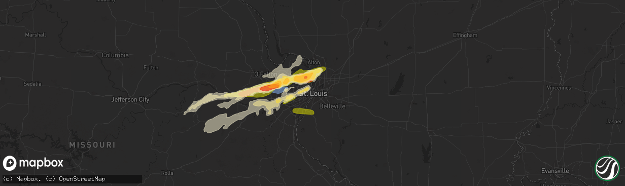
Hail Map in Saint Louis, MO on April 1, 2024
The weather event in Saint Louis, MO on April 1, 2024 includes Hail, Wind, and Tornado maps. 13 states and 893 cities were impacted and suffered possible damage. The total estimated number of properties impacted is 73,541.
Hail
Wind
Tornado
73,541
Estimated number of impacted properties by a 1.00" hail or larger55,860
Estimated number of impacted properties by a 1.75" hail or larger0
Estimated number of impacted properties by a 2.50" hail or largerStorm reports in Saint Louis, MO
Saint Louis, MO
| Date | Description |
|---|---|
| 04/01/20246:59 PM CDT | Unsure on the true size of the stones... But was confident they were larger than quarters. |
| 04/01/20246:57 PM CDT | Estimated ping pong ball sized hail from emailed photo. |
| 04/01/20246:56 PM CDT | A local report indicates 1.50 inch wind near Ferguson |
| 04/01/20246:55 PM CDT | Picture of golf ball sized hail in ferguson estimated compared to penny in hand. |
| 04/01/20242:01 AM CDT | Report from mping: quarter |
| 04/01/20241:55 AM CDT | Mping report of quarter sized hail. |
| 04/01/20241:55 AM CDT | Quarter sized hail in oakville. |
| 04/01/20241:55 AM CDT | Report from mping: quarter |
| 03/31/202411:28 PM CDT | Quarter sized hail in rock hill. |
| 03/31/202411:21 PM CDT | Quarter sized hail. |
All States Impacted by Hail Map on April 1, 2024
All Cities Impacted by Hail Map on April 1, 2024
- Chapin, IL
- Concord, IL
- Jacksonville, IL
- Arenzville, IL
- Tallula, IL
- Hennessey, OK
- Perry, OK
- Red Rock, OK
- Bison, OK
- Douglas, OK
- Waukomis, OK
- Kingfisher, OK
- Dover, OK
- Crescent, OK
- Sweetwater, TX
- Covington, OK
- Colorado City, TX
- Fairmont, OK
- Loraine, TX
- Roscoe, TX
- Garber, OK
- Marland, OK
- Marshall, OK
- Orlando, OK
- Rotan, TX
- Billings, OK
- Ponca City, OK
- Burbank, OK
- Shidler, OK
- Hamlin, TX
- Lucien, OK
- Cosby, MO
- Trent, TX
- Merkel, TX
- Pawhuska, OK
- Sedan, KS
- Maryneal, TX
- Amity, MO
- King City, MO
- Union Star, MO
- Cedar Vale, KS
- Maysville, MO
- Helena, MO
- Clarksdale, MO
- Kaw City, OK
- Morrison, OK
- Hawley, TX
- Anson, TX
- Peru, KS
- Petersburg, KY
- Burlington, KY
- Chautauqua, KS
- Abilene, TX
- Aurora, IN
- Rising Sun, IN
- McFall, MO
- Blackwell, TX
- Fairfax, OK
- Sylvester, TX
- Pawnee, OK
- Lueders, TX
- Niotaze, KS
- Havana, KS
- Ralston, OK
- Albany, TX
- Aspermont, TX
- Old Glory, TX
- Bronte, TX
- Latonia, KY
- Newport, KY
- Ft Mitchell, KY
- Albany, MO
- Darlington, MO
- Wingate, TX
- New Hampton, MO
- Winters, TX
- Tuscola, TX
- Ovalo, TX
- Stanberry, MO
- Bethany, MO
- Alexandria, KY
- Melbourne, KY
- Martinsville, MO
- Seymour, TX
- Crowell, TX
- Caney, KS
- Copan, OK
- Eagleville, MO
- Morning View, KY
- Independence, KY
- Ridgeway, MO
- Blythedale, MO
- Tyro, KS
- Wann, OK
- Independence, KS
- Coffeyville, KS
- Dearing, KS
- Liberty, KS
- Breckenridge, TX
- Clyde, TX
- Lawn, TX
- Lyndon, KS
- Lebo, KS
- California, KY
- New Richmond, OH
- Vassar, KS
- Overbrook, KS
- Quenemo, KS
- Butler, KY
- Vernon, TX
- Moscow, OH
- Cherryvale, KS
- Baird, TX
- Mound Valley, KS
- Edna, KS
- Cisco, TX
- Bethel, OH
- Bartlesville, OK
- Moline, KS
- Grenola, KS
- Hamersville, OH
- Goldsboro, TX
- Elk City, KS
- Felicity, OH
- Altamont, KS
- Parsons, KS
- Chillicothe, TX
- Moran, TX
- Woodson, TX
- Owensville, MO
- Foster, KY
- Dewey, OK
- Coleman, TX
- South Bend, TX
- Neville, OH
- Graham, TX
- Oswego, KS
- Graford, TX
- Strawn, TX
- Georgetown, OH
- Eastland, TX
- Hermann, MO
- Berger, MO
- New Haven, MO
- Gerald, MO
- Cross Plains, TX
- Rising Star, TX
- Barnett, MO
- Dennis, KS
- Thayer, KS
- Versailles, MO
- Caddo, TX
- Neodesha, KS
- McCune, KS
- Eldon, MO
- Russellville, MO
- Ranger, TX
- Bryson, TX
- Carbon, TX
- Marthasville, MO
- Burkett, TX
- Washington, MO
- Augusta, KY
- Eldorado, TX
- Okarche, OK
- Rich Hill, MO
- Perrin, TX
- Jacksboro, TX
- Eugene, MO
- Lohman, MO
- Olean, MO
- Jefferson City, MO
- Henley, MO
- Gorman, TX
- Mineral Wells, TX
- Augusta, MO
- Saint Thomas, MO
- Desdemona, TX
- Santa Anna, TX
- Mulhall, OK
- Guthrie, OK
- California, MO
- Leslie, MO
- Gouldbusk, TX
- Loyal, OK
- Defiance, MO
- Foristell, MO
- Weatherford, TX
- Whitt, TX
- Poolville, TX
- De Leon, TX
- Saint Charles, MO
- Westphalia, MO
- Bonnots Mill, MO
- Loose Creek, MO
- Meta, MO
- Springtown, TX
- Dublin, TX
- Mingus, TX
- Brownwood, TX
- Lamar, MO
- Stillwater, OK
- Liberal, MO
- Bangs, TX
- O'Fallon, MO
- Saint Albans, MO
- Chesterfield, MO
- Wildwood, MO
- Stephenville, TX
- Early, TX
- Jerico Springs, MO
- Sheldon, MO
- Paradise, TX
- Boyd, TX
- Linn, MO
- Gordon, TX
- Ballwin, MO
- Saint Louis, MO
- Hydro, OK
- Saint Peters, MO
- Geary, OK
- Godfrey, IL
- Alton, IL
- Hinton, OK
- Bridgeport, TX
- May, TX
- Maryland Heights, MO
- Earth City, MO
- Bridgeton, MO
- Rhome, TX
- Azle, TX
- Saint Ann, MO
- Lipan, TX
- Bluff Dale, TX
- Blanket, TX
- Hazelwood, MO
- Chamois, MO
- Zephyr, TX
- Florissant, MO
- Newark, TX
- Tolar, TX
- Granbury, TX
- Palmer, IL
- Taylorville, IL
- Carnegie, OK
- Brookesmith, TX
- Lohn, TX
- Rochelle, TX
- Watonga, OK
- Jasper, MO
- Stonington, IL
- Canute, OK
- Dill City, OK
- Foss, OK
- Decatur, TX
- Comanche, TX
- Fort Worth, TX
- Haslet, TX
- Lockwood, MO
- Stockton, MO
- Justin, TX
- Menard, TX
- Rocksprings, TX
- Sonora, TX
- Brighton, IL
- El Dorado Springs, MO
- Morrison, MO
- Moweaqua, IL
- Collins, MO
- Dover, KY
- Ripley, OH
- Perkins, OK
- Coyle, OK
- Calumet, OK
- Ripley, OK
- Glencoe, OK
- Glen Rose, TX
- Wood River, IL
- Roxana, IL
- Granite City, IL
- South Roxana, IL
- East Alton, IL
- Hartford, IL
- Denton, TX
- Argyle, TX
- Yale, OK
- Hominy, OK
- Wynona, OK
- Assumption, IL
- Bland, MO
- Fair Play, MO
- Owaneco, IL
- Arcola, MO
- Richland Springs, TX
- San Saba, TX
- Bethany, IL
- Elsah, IL
- West Alton, MO
- Portage Des Sioux, MO
- Dalton City, IL
- Mount Sterling, MO
- Humansville, MO
- Hico, TX
- Iredell, TX
- Barnsdall, OK
- Dadeville, MO
- Dunnegan, MO
- Bolivar, MO
- Polk, MO
- Godley, TX
- Cleburne, TX
- Maramec, OK
- Jennings, OK
- Cleveland, OK
- Glasgow, VA
- Buena Vista, VA
- Natural Bridge, VA
- Lexington, VA
- Ponder, TX
- Camargo, IL
- Tuscola, IL
- Roanoke, TX
- Coalgate, OK
- Mount Hope, WV
- Warrenton, MO
- Yucca, AZ
- Montgomery City, MO
- Rainbow, TX
- Cresson, TX
- Aledo, TX
- Half Way, MO
- Louisburg, MO
- Meridian, TX
- Walnut Springs, TX
- Wright City, MO
- Joshua, TX
- Crowley, TX
- Buffalo, MO
- Ochelata, OK
- Goldthwaite, TX
- Wardville, OK
- Mcalester, OK
- Stuart, OK
- Villa Grove, IL
- Weaubleau, MO
- Gravois Mills, MO
- Monroe, VA
- Morgan, TX
- Nemo, TX
- Windyville, MO
- Tunas, MO
- Osage, OK
- Keene, TX
- Burleson, TX
- Alvarado, TX
- Ramona, OK
- Wentzville, MO
- Prue, OK
- Slab Fork, WV
- Lake Ozark, MO
- Hermitage, MO
- Preston, MO
- Vesuvius, VA
- Amherst, VA
- Camdenton, MO
- Rocky Mount, MO
- Sunrise Beach, MO
- Evant, TX
- Star, TX
- Roseland, VA
- Nowata, OK
- Delaware, OK
- Oak Hill, WV
- Venus, TX
- Grandview, TX
- Skiatook, OK
- Lenapah, OK
- Midlothian, TX
- Climax Springs, MO
- Tuscumbia, MO
- Rhodell, WV
- Coal City, WV
- Josephine, WV
- Princewick, WV
- Lake Saint Louis, MO
- Rio Vista, TX
- Greencastle, IN
- Arrington, VA
- Wheatland, MO
- Quincy, MO
- Mountain Home, TX
- Hamilton, TX
- Savanna, OK
- Little Elm, TX
- Aubrey, TX
- Kaiser, MO
- Osage Beach, MO
- Ingram, TX
- Talala, OK
- Waxahachie, TX
- Vinita, OK
- Chelsea, OK
- S Coffeyville, OK
- Welch, OK
- Bainbridge, IN
- Coatesville, IN
- Harper, TX
- Gatesville, TX
- Purmela, TX
- Jonesboro, TX
- Macks Creek, MO
- Clifton, TX
- Centertown, MO
- Lampasas, TX
- Lometa, TX
- Fredericksburg, TX
- Prosper, TX
- Bluejacket, OK
- Ennis, TX
- Palmer, TX
- Red Oak, TX
- Fillmore, IN
- Kerrville, TX
- Danville, IN
- Holts Summit, MO
- Copperas Cove, TX
- Hunt, TX
- Electra, TX
- Girard, KS
- Itasca, TX
- Hillsboro, TX
- Milford, TX
- Columbus, KS
- Chetopa, KS
- Bartlett, KS
- Lancaster, TX
- Wilmer, TX
- Ferris, TX
- Baxter Springs, KS
- Miami, OK
- Stonewall, TX
- Hye, TX
- Johnson City, TX
- Meridian, OK
- Valley Mills, TX
- Steedman, MO
- Comfort, TX
- Italy, TX
- Tebbetts, MO
- New Bloomfield, MO
- Knippa, TX
- Iowa Park, TX
- Scurry, TX
- Crandall, TX
- Rosser, TX
- Kaufman, TX
- Seagoville, TX
- Galena, KS
- Scammon, KS
- Weir, KS
- Saint Elizabeth, MO
- Pittsburg, KS
- Sabinal, TX
- Cherokee, KS
- Brazil, IN
- Boerne, TX
- D Hanis, TX
- Picher, OK
- Quapaw, OK
- Center Point, TX
- Axtell, TX
- Elm Mott, TX
- Waco, TX
- Rhineland, MO
- Carl Junction, MO
- Webb City, MO
- Joplin, MO
- Riverton, KS
- Carterville, MO
- Oronogo, MO
- Purcell, MO
- Carthage, MO
- Alba, MO
- Jonesburg, MO
- Hondo, TX
- Duenweg, MO
- Mount Calm, TX
- Hubbard, TX
- Coolidge, TX
- Dripping Springs, TX
- Wills Point, TX
- Dawson, TX
- Austin, TX
- Spicewood, TX
- Golden City, MO
- Avilla, MO
- Reeds, MO
- Sarcoxie, MO
- Miller, MO
- La Russell, MO
- Castroville, TX
- Mico, TX
- San Antonio, TX
- Rio Medina, TX
- Diamond, MO
- Leander, TX
- Mannford, OK
- Drumright, OK
- Comanche, OK
- Duncan, OK
- Big Cabin, OK
- Foster, OK
- Terlton, OK
- Lindsay, OK
- Elmore City, OK
- Maysville, OK
- Pauls Valley, OK
- Greenfield, MO
- South Greenfield, MO
- Sand Springs, OK
- Sapulpa, OK
- Troy, MO
- Hennepin, OK
- Springer, OK
- Wellston, OK
- Ratliff City, OK
- Richland, TX
- Wortham, TX
- Jbsa Ft Sam Houston, TX
- Everton, MO
- Tulsa, OK
- Willard, MO
- Ash Grove, MO
- Belle, MO
- Afton, OK
- Paoli, OK
- Wayne, OK
- Pacific, MO
- Walnut Grove, MO
- Fairland, OK
- Aldrich, MO
- Pleasant Hope, MO
- Rosebud, MO
- Converse, TX
- Brighton, MO
- Bristow, OK
- Morrisville, MO
- Union, MO
- West Mineral, KS
- Seneca, MO
- Springfield, MO
- Eldridge, MO
- Schertz, TX
- Jbsa Randolph, TX
- Cibolo, TX
- Urbana, MO
- Labadie, MO
- Elkland, MO
- Villa Ridge, MO
- Lebanon, MO
- Marion, TX
- Fair Grove, MO
- Claremore, OK
- Long Lane, MO
- Brumley, MO
- Stoutland, MO
- Richland, MO
- Seguin, TX
- Marshfield, MO
- Eureka, MO
- Gray Summit, MO
- Crocker, MO
- McQueeney, TX
- Sullivan, MO
- Beaufort, MO
- Inola, OK
- Okmulgee, OK
- Valley Park, MO
- Fenton, MO
- Niangua, MO
- Conway, MO
- Morris, OK
- Mount Vernon, IL
- High Ridge, MO
- Saint Clair, MO
- Phillipsburg, MO
- Pryor, OK
- Chouteau, OK
- Iberia, MO
- Montreal, MO
- Ulman, MO
- Linn Creek, MO
- Keenes, IL
- Bluford, IL
- Spavinaw, OK
- Dixon, MO
- Laquey, MO
- Falcon, MO
- Waynesville, MO
- Fort Leonard Wood, MO
- East Saint Louis, IL
- Argyle, MO
- Kenefic, OK
- Durant, OK
- Caddo, OK
- Atoka, OK
- Kiowa, OK
- Newburg, MO
- Mount Vernon, MO
- Rolla, MO
- Blanco, OK
- Stotts City, MO
- Saint Robert, MO
- Devils Elbow, MO
- Duke, MO
- Edgar Springs, MO
- Cook Sta, MO
- Saint James, MO
- Cuba, MO
- Vichy, MO
- Braggs, OK
- Gore, OK
- Muskogee, OK
- Bunch, OK
- Cookson, OK
- Vian, OK
- Park Hill, OK
- Stilwell, OK
- Evansville, AR
- Natural Dam, AR
- Canehill, AR
- West Fork, AR
- Prairie Grove, AR
- Steelville, MO
- Potosi, MO
- Robinson, IL
- Winslow, AR
- Belgrade, MO
- Hutsonville, IL
- Fayetteville, AR
- Park Hills, MO
- Leadwood, MO
- Bonne Terre, MO
- French Village, MO
- Irondale, MO
- Valles Mines, MO
- Bismarck, MO
- Elkins, AR
- East Carondelet, IL
- Dupo, IL
- Collinsville, IL
- Maryville, IL
- Sainte Genevieve, MO
- Sparta, IL
- Saint Mary, MO
- Ellis Grove, IL
- Evansville, IL
- Walsh, IL
- Perryville, MO
- Chester, IL
- Steeleville, IL
- Coulterville, IL
- Bloomfield, IN
- Campbell Hill, IL
- Percy, IL
- Cutler, IL
- Martinsville, IN
- Switz City, IN
- San Marcos, TX
- Franklin, IN
- Morgantown, IN
- Nashville, IL
- Solsberry, IN
- Pinckneyville, IL
- Odd, WV
- Huntsville, TX
- Beckley, WV
- Bargersville, IN
- Huntsville, AR
- New Braunfels, TX
- Maxwell, TX
- Lockhart, TX
- Kyle, TX
- Tamaroa, IL
- Scheller, IL
- Iuka, IL
- Xenia, IL
- Sesser, IL
- Du Quoin, IL
- Johnsonville, IL
- Kingston, AR
- Ponca, AR
- Columbia, IL
- Compton, AR
- Opdyke, IL
- Belle Rive, IL
- Bonnie, IL
- Milroy, IN
- Rushville, IN
- Bloomsdale, MO
- Prairie Du Rocher, IL
- Jasper, AR
- Dahlgren, IL
- Wayne City, IL
- Mineral Point, MO
- Cadet, MO
- House Springs, MO
- Kingsbury, TX
- Fairfield, IL
- Cisne, IL
- Modoc, IL
- Sims, IL
- Oakdale, IL
- Glenwood, IN
- Connersville, IN
- Laurel, IN
- Chaffee, MO
- Mount Erie, IL
- Liberty, IN
- Metamora, IN
- Brookville, IN
- Albion, IL
- Ellery, IL
- Golden Gate, IL
- Bone Gap, IL
- West Salem, IL
- Waltonville, IL
- Mount Carmel, IL
- West College Corner, IN
- Lyons, IN
- Tamms, IL
- Jonesboro, IL
- Thebes, IL
- McClure, IL
- Allendale, IL
- Ullin, IL
- Dongola, IL
- Raleigh, IL
- Eldorado, IL
- Harrisburg, IL
- Omaha, IL
- Norris City, IL
- New Haven, IL
- Carmi, IL
- Mount Vernon, IN
- Equality, IL
- Junction, IL
- Ridgway, IL
- Shawneetown, IL
- Round Mountain, TX
- Poseyville, IN
- Fort Branch, IN
- Cynthiana, IN
- Haubstadt, IN
- Wadesville, IN
- Evansville, IN
- Chandler, IN
- Elberfeld, IN
- Newburgh, IN
- Lynnville, IN
- Boonville, IN
- Tennyson, IN
- Oakland City, IN
- Haynesville, LA
- Shongaloo, LA
- Gentryville, IN
- Chrisney, IN
- Rockport, IN
- Richland, IN
- Grandview, IN
- Lincoln City, IN
- Lamar, IN
- Holland, IN
- Dale, IN
- Santa Claus, IN
- Ferdinand, IN
- Evanston, IN
- Saint Meinrad, IN
- Warren, AR
- Banks, AR
- Emerson, AR
- English, IN
- Bristow, IN
- Saint Croix, IN
- Birdseye, IN
- Troy, IN
- Lewisport, KY
- Tell City, IN
- Hawesville, KY
- New Edinburg, AR
- Sulphur, IN
- Grantsburg, IN
- Whitewater, MO
- Jackson, MO
- Cape Girardeau, MO
- Marble Hill, MO
- Burfordville, MO
- Daisy, MO
- Friedheim, MO
- Oak Ridge, MO
- Millersville, MO
- Sedgewickville, MO
- Leopold, MO
- Marquand, MO
- Patton, MO
- Glenallen, MO
- Fredericktown, MO
- Greenville, MO
- Zalma, MO
- Miller City, IL
- Charleston, MO
- Cairo, IL
- Oran, MO
- Advance, MO
- Scott City, MO
- Sikeston, MO
- Benton, MO
- Olive Branch, IL
- Olmsted, IL
- Mounds, IL
- Grand Chain, IL
- Pulaski, IL
- Pomona, IL
- Old Appleton, MO
- Anna, IL
- Carbondale, IL
- Cypress, IL
- Frohna, MO
- Altenburg, MO
- Mound City, IL
- Alto Pass, IL
- Goreville, IL
- Buncombe, IL
- Jacob, IL
- Villa Ridge, IL
- Barlow, KY
- Marion, IL
- Grand Tower, IL
- Cobden, IL
- Murphysboro, IL
- Uniontown, MO
- Gorham, IL
- Wolf Lake, IL
- Makanda, IL
- Farrar, MO
- Carterville, IL
- New Burnside, IL
- Ozark, IL
- Galatia, IL
- Stonefort, IL
- Belknap, IL
- Kevil, KY
- La Center, KY
- Carrier Mills, IL
- Vienna, IL
- Karnak, IL
- Creal Springs, IL
- Simpson, IL
- Marion, KY
- Golconda, IL
- Grantsburg, IL
- Metropolis, IL
- Elizabethtown, IL
- Rosiclare, IL
- Salem, KY
- West Paducah, KY
- Eddyville, IL
- Herod, IL
- Wickliffe, KY
- Hampton, KY
- Smithland, KY
- Paducah, KY
- Brookport, IL
- Burna, KY
- Cave In Rock, IL
- De Mossville, KY
- Bloomington, IN
- Farmington, MO
- Bath, IN
- Trafalgar, IN
- Nineveh, IN
- Manilla, IN
- Festus, MO
- Waldron, IN
- Shelbyville, IN
- Bourbon, MO
- Garfield, AR
- Grovespring, MO
- Morganfield, KY
- Uniontown, KY
- Waverly, KY
- New Harmony, IN
- Sturgis, KY


