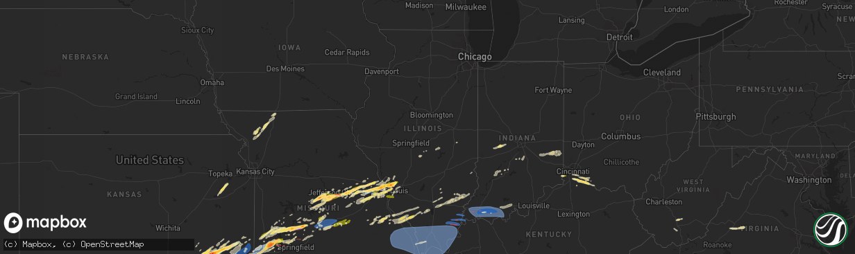
Hail Map in Illinois on April 1, 2024
The weather event in Illinois on April 1, 2024 includes Hail, Wind, and Tornado maps. 13 states and 893 cities were impacted and suffered possible damage. The total estimated number of properties impacted is 6,077.
Want more than just the map?
Turn this storm into a full workflow.
- Owner + property data so you know who to knock
- OnDemand branded weather history reports to win the "did we even have hail?" argument
- RoofTrace estimate so reps stop guessing numbers at the door
Bought this map? Upgrade within 7 days and we'll credit the $230. (10-15 min setup call)
Hail
Wind
Tornado
6,077
Estimated number of impacted properties by a 1.00" hail or larger0
Estimated number of impacted properties by a 1.75" hail or larger0
Estimated number of impacted properties by a 2.50" hail or largerStorm reports in Illinois
Illinois
| Date | Description |
|---|---|
| 04/01/20246:37 PM CDT | A local report indicates 1.25 inch wind near 3 NW Assumption |
| 04/01/20243:14 PM CDT | Trained spotter reports hail east of kankakee with most stones near pea size... But a few hail stones up to quarter size mixed in. Time estimated by radar. |
| 04/01/20245:31 AM CDT | Hundreds of trees uprooted or snapped. Several outbuildings/sheds were damaged or destroyed. Minor to moderate roof damage to several homes. Path started just west of t |
| 04/01/20245:24 AM CDT | Large tree snapped at the base. Relayed via facebook. |
| 04/01/20245:23 AM CDT | Grain bin blown into the roadway near ridgway. |
| 04/01/20245:22 AM CDT | An ef-1 tornado impacted far northeast gallatin county... Il... And extreme southwest posey county... In... During the early morning hours of tuesday... April 2. The to |
| 04/01/20245:21 AM CDT | A brief ef-1 tornado impacted the west side of ridgway... Il... During the early morning hours of tuesday... April 2. The tornado began just south of main street along |
| 04/01/20245:15 AM CDT | *** 2 inj *** an ef-2 tornado occurred approximately two miles southeast of eldorado during the early morning hours of tuesday... April 8th. The tornado began near the |
| 04/01/20245:13 AM CDT | Possible tornado. Several out buildings destroyed. Home severely damaged. Powerlines down. |
| 04/01/20245:11 AM CDT | Trees snapped at the ground. |
| 04/01/20245:02 AM CDT | Large trees down. |
| 04/01/20244:57 AM CDT | Widespread tree/powerline damage. More significant structural damage near lake of egypt and east to stonefort. Radar indicated tds in this area. |
| 04/01/20244:56 AM CDT | An ef-1 tornado impacted the stonefort community during the early morning hours of tuesday... April 2. The tornado began just east of creal springs along saltpetre road |
| 04/01/20244:55 AM CDT | High winds reported. Power out in rural area. |
| 04/01/20244:55 AM CDT | Roof damage to outbuildings... Tree snapped... And boat blown around. |
| 04/01/20244:50 AM CDT | Awos station kcir cairo il. |
| 04/01/20244:50 AM CDT | Corrects previous tornado report from 5 w creal springs. Sporadic trees and power poles snapped in the north shoreland subdivision. |
| 04/01/20244:50 AM CDT | Two large trees down... Including an uprooted oak tree and a pine tree snapped. |
| 04/01/20244:50 AM CDT | Sporadic trees and power poles snapped in the north shoreland subdivision. |
| 04/01/20244:49 AM CDT | Newly constructed pole barn blown down in goreville. |
| 04/01/20244:46 AM CDT | Several mature trees blown over or snapped. Possible tornado. |
| 04/01/20244:46 AM CDT | An ef-2 tornado impacted the lake of egypt community in the early morning hours of tuesday... April 2. The tornado began along highway 148... Just west of interstate 57 |
| 04/01/20244:38 AM CDT | New constructed pole barn that was still unfinished was blown down. |
| 04/01/20244:37 AM CDT | Several snapped trees and siding removed from a home. |
| 04/01/20244:22 AM CDT | Mesonet station up809 3.6 se grand tower |
| 04/01/20244:17 AM CDT | 428 residents out of power in the gorham/grand tower area. |
| 04/01/20244:15 AM CDT | Report from mping of 1.5 inch hail. |
| 04/01/20242:44 AM CDT | Tree downed onto a trailer in culter. Time estimated by radar. |
| 04/01/20242:40 AM CDT | Time estimated from radar. Quarter sized hail. |
| 04/01/20242:32 AM CDT | Corrects previous tstm wnd dmg report from 1 ese chester. Power poles snapped and power lines downed east of chester. |
| 04/01/20242:32 AM CDT | Several power poles down east of town. |
| 04/01/20241:58 AM CDT | Quarter sized hail on the north side of columbia. |
| 04/01/20241:58 AM CDT | Mping report of quarter sized hail just north of columbia. |
| 04/01/20241:57 AM CDT | Report from mping: quarter |
All States Impacted by Hail Map on April 1, 2024
Cities Impacted by Hail Map on April 1, 2024
- Chapin, IL
- Concord, IL
- Jacksonville, IL
- Arenzville, IL
- Tallula, IL
- Hennessey, OK
- Perry, OK
- Red Rock, OK
- Bison, OK
- Douglas, OK
- Waukomis, OK
- Kingfisher, OK
- Dover, OK
- Crescent, OK
- Sweetwater, TX
- Covington, OK
- Colorado City, TX
- Fairmont, OK
- Loraine, TX
- Roscoe, TX
- Garber, OK
- Marland, OK
- Marshall, OK
- Orlando, OK
- Rotan, TX
- Billings, OK
- Ponca City, OK
- Burbank, OK
- Shidler, OK
- Hamlin, TX
- Lucien, OK
- Cosby, MO
- Trent, TX
- Merkel, TX
- Pawhuska, OK
- Sedan, KS
- Maryneal, TX
- Amity, MO
- King City, MO
- Union Star, MO
- Cedar Vale, KS
- Maysville, MO
- Helena, MO
- Clarksdale, MO
- Kaw City, OK
- Morrison, OK
- Hawley, TX
- Anson, TX
- Peru, KS
- Petersburg, KY
- Burlington, KY
- Chautauqua, KS
- Abilene, TX
- Aurora, IN
- Rising Sun, IN
- McFall, MO
- Blackwell, TX
- Fairfax, OK
- Sylvester, TX
- Pawnee, OK
- Lueders, TX
- Niotaze, KS
- Havana, KS
- Ralston, OK
- Albany, TX
- Aspermont, TX
- Old Glory, TX
- Bronte, TX
- Latonia, KY
- Newport, KY
- Ft Mitchell, KY
- Albany, MO
- Darlington, MO
- Wingate, TX
- New Hampton, MO
- Winters, TX
- Tuscola, TX
- Ovalo, TX
- Stanberry, MO
- Bethany, MO
- Alexandria, KY
- Melbourne, KY
- Martinsville, MO
- Seymour, TX
- Crowell, TX
- Caney, KS
- Copan, OK
- Eagleville, MO
- Morning View, KY
- Independence, KY
- Ridgeway, MO
- Blythedale, MO
- Tyro, KS
- Wann, OK
- Independence, KS
- Coffeyville, KS
- Dearing, KS
- Liberty, KS
- Breckenridge, TX
- Clyde, TX
- Lawn, TX
- Lyndon, KS
- Lebo, KS
- California, KY
- New Richmond, OH
- Vassar, KS
- Overbrook, KS
- Quenemo, KS
- Butler, KY
- Vernon, TX
- Moscow, OH
- Cherryvale, KS
- Baird, TX
- Mound Valley, KS
- Edna, KS
- Cisco, TX
- Bethel, OH
- Bartlesville, OK
- Moline, KS
- Grenola, KS
- Hamersville, OH
- Goldsboro, TX
- Elk City, KS
- Felicity, OH
- Altamont, KS
- Parsons, KS
- Chillicothe, TX
- Moran, TX
- Woodson, TX
- Owensville, MO
- Foster, KY
- Dewey, OK
- Coleman, TX
- South Bend, TX
- Neville, OH
- Graham, TX
- Oswego, KS
- Graford, TX
- Strawn, TX
- Georgetown, OH
- Eastland, TX
- Hermann, MO
- Berger, MO
- New Haven, MO
- Gerald, MO
- Cross Plains, TX
- Rising Star, TX
- Barnett, MO
- Dennis, KS
- Thayer, KS
- Versailles, MO
- Caddo, TX
- Neodesha, KS
- McCune, KS
- Eldon, MO
- Russellville, MO
- Ranger, TX
- Bryson, TX
- Carbon, TX
- Marthasville, MO
- Burkett, TX
- Washington, MO
- Augusta, KY
- Eldorado, TX
- Okarche, OK
- Rich Hill, MO
- Perrin, TX
- Jacksboro, TX
- Eugene, MO
- Lohman, MO
- Olean, MO
- Jefferson City, MO
- Henley, MO
- Gorman, TX
- Mineral Wells, TX
- Augusta, MO
- Saint Thomas, MO
- Desdemona, TX
- Santa Anna, TX
- Mulhall, OK
- Guthrie, OK
- California, MO
- Leslie, MO
- Gouldbusk, TX
- Loyal, OK
- Defiance, MO
- Foristell, MO
- Weatherford, TX
- Whitt, TX
- Poolville, TX
- De Leon, TX
- Saint Charles, MO
- Westphalia, MO
- Bonnots Mill, MO
- Loose Creek, MO
- Meta, MO
- Springtown, TX
- Dublin, TX
- Mingus, TX
- Brownwood, TX
- Lamar, MO
- Stillwater, OK
- Liberal, MO
- Bangs, TX
- O'Fallon, MO
- Saint Albans, MO
- Chesterfield, MO
- Wildwood, MO
- Stephenville, TX
- Early, TX
- Jerico Springs, MO
- Sheldon, MO
- Paradise, TX
- Boyd, TX
- Linn, MO
- Gordon, TX
- Ballwin, MO
- Saint Louis, MO
- Hydro, OK
- Saint Peters, MO
- Geary, OK
- Godfrey, IL
- Alton, IL
- Hinton, OK
- Bridgeport, TX
- May, TX
- Maryland Heights, MO
- Earth City, MO
- Bridgeton, MO
- Rhome, TX
- Azle, TX
- Saint Ann, MO
- Lipan, TX
- Bluff Dale, TX
- Blanket, TX
- Hazelwood, MO
- Chamois, MO
- Zephyr, TX
- Florissant, MO
- Newark, TX
- Tolar, TX
- Granbury, TX
- Palmer, IL
- Taylorville, IL
- Carnegie, OK
- Brookesmith, TX
- Lohn, TX
- Rochelle, TX
- Watonga, OK
- Jasper, MO
- Stonington, IL
- Canute, OK
- Dill City, OK
- Foss, OK
- Decatur, TX
- Comanche, TX
- Fort Worth, TX
- Haslet, TX
- Lockwood, MO
- Stockton, MO
- Justin, TX
- Menard, TX
- Rocksprings, TX
- Sonora, TX
- Brighton, IL
- El Dorado Springs, MO
- Morrison, MO
- Moweaqua, IL
- Collins, MO
- Dover, KY
- Ripley, OH
- Perkins, OK
- Coyle, OK
- Calumet, OK
- Ripley, OK
- Glencoe, OK
- Glen Rose, TX
- Wood River, IL
- Roxana, IL
- Granite City, IL
- South Roxana, IL
- East Alton, IL
- Hartford, IL
- Denton, TX
- Argyle, TX
- Yale, OK
- Hominy, OK
- Wynona, OK
- Assumption, IL
- Bland, MO
- Fair Play, MO
- Owaneco, IL
- Arcola, MO
- Richland Springs, TX
- San Saba, TX
- Bethany, IL
- Elsah, IL
- West Alton, MO
- Portage Des Sioux, MO
- Dalton City, IL
- Mount Sterling, MO
- Humansville, MO
- Hico, TX
- Iredell, TX
- Barnsdall, OK
- Dadeville, MO
- Dunnegan, MO
- Bolivar, MO
- Polk, MO
- Godley, TX
- Cleburne, TX
- Maramec, OK
- Jennings, OK
- Cleveland, OK
- Glasgow, VA
- Buena Vista, VA
- Natural Bridge, VA
- Lexington, VA
- Ponder, TX
- Camargo, IL
- Tuscola, IL
- Roanoke, TX
- Coalgate, OK
- Mount Hope, WV
- Warrenton, MO
- Yucca, AZ
- Montgomery City, MO
- Rainbow, TX
- Cresson, TX
- Aledo, TX
- Half Way, MO
- Louisburg, MO
- Meridian, TX
- Walnut Springs, TX
- Wright City, MO
- Joshua, TX
- Crowley, TX
- Buffalo, MO
- Ochelata, OK
- Goldthwaite, TX
- Wardville, OK
- Mcalester, OK
- Stuart, OK
- Villa Grove, IL
- Weaubleau, MO
- Gravois Mills, MO
- Monroe, VA
- Morgan, TX
- Nemo, TX
- Windyville, MO
- Tunas, MO
- Osage, OK
- Keene, TX
- Burleson, TX
- Alvarado, TX
- Ramona, OK
- Wentzville, MO
- Prue, OK
- Slab Fork, WV
- Lake Ozark, MO
- Hermitage, MO
- Preston, MO
- Vesuvius, VA
- Amherst, VA
- Camdenton, MO
- Rocky Mount, MO
- Sunrise Beach, MO
- Evant, TX
- Star, TX
- Roseland, VA
- Nowata, OK
- Delaware, OK
- Oak Hill, WV
- Venus, TX
- Grandview, TX
- Skiatook, OK
- Lenapah, OK
- Midlothian, TX
- Climax Springs, MO
- Tuscumbia, MO
- Rhodell, WV
- Coal City, WV
- Josephine, WV
- Princewick, WV
- Lake Saint Louis, MO
- Rio Vista, TX
- Greencastle, IN
- Arrington, VA
- Wheatland, MO
- Quincy, MO
- Mountain Home, TX
- Hamilton, TX
- Savanna, OK
- Little Elm, TX
- Aubrey, TX
- Kaiser, MO
- Osage Beach, MO
- Ingram, TX
- Talala, OK
- Waxahachie, TX
- Vinita, OK
- Chelsea, OK
- S Coffeyville, OK
- Welch, OK
- Bainbridge, IN
- Coatesville, IN
- Harper, TX
- Gatesville, TX
- Purmela, TX
- Jonesboro, TX
- Macks Creek, MO
- Clifton, TX
- Centertown, MO
- Lampasas, TX
- Lometa, TX
- Fredericksburg, TX
- Prosper, TX
- Bluejacket, OK
- Ennis, TX
- Palmer, TX
- Red Oak, TX
- Fillmore, IN
- Kerrville, TX
- Danville, IN
- Holts Summit, MO
- Copperas Cove, TX
- Hunt, TX
- Electra, TX
- Girard, KS
- Itasca, TX
- Hillsboro, TX
- Milford, TX
- Columbus, KS
- Chetopa, KS
- Bartlett, KS
- Lancaster, TX
- Wilmer, TX
- Ferris, TX
- Baxter Springs, KS
- Miami, OK
- Stonewall, TX
- Hye, TX
- Johnson City, TX
- Meridian, OK
- Valley Mills, TX
- Steedman, MO
- Comfort, TX
- Italy, TX
- Tebbetts, MO
- New Bloomfield, MO
- Knippa, TX
- Iowa Park, TX
- Scurry, TX
- Crandall, TX
- Rosser, TX
- Kaufman, TX
- Seagoville, TX
- Galena, KS
- Scammon, KS
- Weir, KS
- Saint Elizabeth, MO
- Pittsburg, KS
- Sabinal, TX
- Cherokee, KS
- Brazil, IN
- Boerne, TX
- D Hanis, TX
- Picher, OK
- Quapaw, OK
- Center Point, TX
- Axtell, TX
- Elm Mott, TX
- Waco, TX
- Rhineland, MO
- Carl Junction, MO
- Webb City, MO
- Joplin, MO
- Riverton, KS
- Carterville, MO
- Oronogo, MO
- Purcell, MO
- Carthage, MO
- Alba, MO
- Jonesburg, MO
- Hondo, TX
- Duenweg, MO
- Mount Calm, TX
- Hubbard, TX
- Coolidge, TX
- Dripping Springs, TX
- Wills Point, TX
- Dawson, TX
- Austin, TX
- Spicewood, TX
- Golden City, MO
- Avilla, MO
- Reeds, MO
- Sarcoxie, MO
- Miller, MO
- La Russell, MO
- Castroville, TX
- Mico, TX
- San Antonio, TX
- Rio Medina, TX
- Diamond, MO
- Leander, TX
- Mannford, OK
- Drumright, OK
- Comanche, OK
- Duncan, OK
- Big Cabin, OK
- Foster, OK
- Terlton, OK
- Lindsay, OK
- Elmore City, OK
- Maysville, OK
- Pauls Valley, OK
- Greenfield, MO
- South Greenfield, MO
- Sand Springs, OK
- Sapulpa, OK
- Troy, MO
- Hennepin, OK
- Springer, OK
- Wellston, OK
- Ratliff City, OK
- Richland, TX
- Wortham, TX
- Jbsa Ft Sam Houston, TX
- Everton, MO
- Tulsa, OK
- Willard, MO
- Ash Grove, MO
- Belle, MO
- Afton, OK
- Paoli, OK
- Wayne, OK
- Pacific, MO
- Walnut Grove, MO
- Fairland, OK
- Aldrich, MO
- Pleasant Hope, MO
- Rosebud, MO
- Converse, TX
- Brighton, MO
- Bristow, OK
- Morrisville, MO
- Union, MO
- West Mineral, KS
- Seneca, MO
- Springfield, MO
- Eldridge, MO
- Schertz, TX
- Jbsa Randolph, TX
- Cibolo, TX
- Urbana, MO
- Labadie, MO
- Elkland, MO
- Villa Ridge, MO
- Lebanon, MO
- Marion, TX
- Fair Grove, MO
- Claremore, OK
- Long Lane, MO
- Brumley, MO
- Stoutland, MO
- Richland, MO
- Seguin, TX
- Marshfield, MO
- Eureka, MO
- Gray Summit, MO
- Crocker, MO
- McQueeney, TX
- Sullivan, MO
- Beaufort, MO
- Inola, OK
- Okmulgee, OK
- Valley Park, MO
- Fenton, MO
- Niangua, MO
- Conway, MO
- Morris, OK
- Mount Vernon, IL
- High Ridge, MO
- Saint Clair, MO
- Phillipsburg, MO
- Pryor, OK
- Chouteau, OK
- Iberia, MO
- Montreal, MO
- Ulman, MO
- Linn Creek, MO
- Keenes, IL
- Bluford, IL
- Spavinaw, OK
- Dixon, MO
- Laquey, MO
- Falcon, MO
- Waynesville, MO
- Fort Leonard Wood, MO
- East Saint Louis, IL
- Argyle, MO
- Kenefic, OK
- Durant, OK
- Caddo, OK
- Atoka, OK
- Kiowa, OK
- Newburg, MO
- Mount Vernon, MO
- Rolla, MO
- Blanco, OK
- Stotts City, MO
- Saint Robert, MO
- Devils Elbow, MO
- Duke, MO
- Edgar Springs, MO
- Cook Sta, MO
- Saint James, MO
- Cuba, MO
- Vichy, MO
- Braggs, OK
- Gore, OK
- Muskogee, OK
- Bunch, OK
- Cookson, OK
- Vian, OK
- Park Hill, OK
- Stilwell, OK
- Evansville, AR
- Natural Dam, AR
- Canehill, AR
- West Fork, AR
- Prairie Grove, AR
- Steelville, MO
- Potosi, MO
- Robinson, IL
- Winslow, AR
- Belgrade, MO
- Hutsonville, IL
- Fayetteville, AR
- Park Hills, MO
- Leadwood, MO
- Bonne Terre, MO
- French Village, MO
- Irondale, MO
- Valles Mines, MO
- Bismarck, MO
- Elkins, AR
- East Carondelet, IL
- Dupo, IL
- Collinsville, IL
- Maryville, IL
- Sainte Genevieve, MO
- Sparta, IL
- Saint Mary, MO
- Ellis Grove, IL
- Evansville, IL
- Walsh, IL
- Perryville, MO
- Chester, IL
- Steeleville, IL
- Coulterville, IL
- Bloomfield, IN
- Campbell Hill, IL
- Percy, IL
- Cutler, IL
- Martinsville, IN
- Switz City, IN
- San Marcos, TX
- Franklin, IN
- Morgantown, IN
- Nashville, IL
- Solsberry, IN
- Pinckneyville, IL
- Odd, WV
- Huntsville, TX
- Beckley, WV
- Bargersville, IN
- Huntsville, AR
- New Braunfels, TX
- Maxwell, TX
- Lockhart, TX
- Kyle, TX
- Tamaroa, IL
- Scheller, IL
- Iuka, IL
- Xenia, IL
- Sesser, IL
- Du Quoin, IL
- Johnsonville, IL
- Kingston, AR
- Ponca, AR
- Columbia, IL
- Compton, AR
- Opdyke, IL
- Belle Rive, IL
- Bonnie, IL
- Milroy, IN
- Rushville, IN
- Bloomsdale, MO
- Prairie Du Rocher, IL
- Jasper, AR
- Dahlgren, IL
- Wayne City, IL
- Mineral Point, MO
- Cadet, MO
- House Springs, MO
- Kingsbury, TX
- Fairfield, IL
- Cisne, IL
- Modoc, IL
- Sims, IL
- Oakdale, IL
- Glenwood, IN
- Connersville, IN
- Laurel, IN
- Chaffee, MO
- Mount Erie, IL
- Liberty, IN
- Metamora, IN
- Brookville, IN
- Albion, IL
- Ellery, IL
- Golden Gate, IL
- Bone Gap, IL
- West Salem, IL
- Waltonville, IL
- Mount Carmel, IL
- West College Corner, IN
- Lyons, IN
- Tamms, IL
- Jonesboro, IL
- Thebes, IL
- McClure, IL
- Allendale, IL
- Ullin, IL
- Dongola, IL
- Raleigh, IL
- Eldorado, IL
- Harrisburg, IL
- Omaha, IL
- Norris City, IL
- New Haven, IL
- Carmi, IL
- Mount Vernon, IN
- Equality, IL
- Junction, IL
- Ridgway, IL
- Shawneetown, IL
- Round Mountain, TX
- Poseyville, IN
- Fort Branch, IN
- Cynthiana, IN
- Haubstadt, IN
- Wadesville, IN
- Evansville, IN
- Chandler, IN
- Elberfeld, IN
- Newburgh, IN
- Lynnville, IN
- Boonville, IN
- Tennyson, IN
- Oakland City, IN
- Haynesville, LA
- Shongaloo, LA
- Gentryville, IN
- Chrisney, IN
- Rockport, IN
- Richland, IN
- Grandview, IN
- Lincoln City, IN
- Lamar, IN
- Holland, IN
- Dale, IN
- Santa Claus, IN
- Ferdinand, IN
- Evanston, IN
- Saint Meinrad, IN
- Warren, AR
- Banks, AR
- Emerson, AR
- English, IN
- Bristow, IN
- Saint Croix, IN
- Birdseye, IN
- Troy, IN
- Lewisport, KY
- Tell City, IN
- Hawesville, KY
- New Edinburg, AR
- Sulphur, IN
- Grantsburg, IN
- Whitewater, MO
- Jackson, MO
- Cape Girardeau, MO
- Marble Hill, MO
- Burfordville, MO
- Daisy, MO
- Friedheim, MO
- Oak Ridge, MO
- Millersville, MO
- Sedgewickville, MO
- Leopold, MO
- Marquand, MO
- Patton, MO
- Glenallen, MO
- Fredericktown, MO
- Greenville, MO
- Zalma, MO
- Miller City, IL
- Charleston, MO
- Cairo, IL
- Oran, MO
- Advance, MO
- Scott City, MO
- Sikeston, MO
- Benton, MO
- Olive Branch, IL
- Olmsted, IL
- Mounds, IL
- Grand Chain, IL
- Pulaski, IL
- Pomona, IL
- Old Appleton, MO
- Anna, IL
- Carbondale, IL
- Cypress, IL
- Frohna, MO
- Altenburg, MO
- Mound City, IL
- Alto Pass, IL
- Goreville, IL
- Buncombe, IL
- Jacob, IL
- Villa Ridge, IL
- Barlow, KY
- Marion, IL
- Grand Tower, IL
- Cobden, IL
- Murphysboro, IL
- Uniontown, MO
- Gorham, IL
- Wolf Lake, IL
- Makanda, IL
- Farrar, MO
- Carterville, IL
- New Burnside, IL
- Ozark, IL
- Galatia, IL
- Stonefort, IL
- Belknap, IL
- Kevil, KY
- La Center, KY
- Carrier Mills, IL
- Vienna, IL
- Karnak, IL
- Creal Springs, IL
- Simpson, IL
- Marion, KY
- Golconda, IL
- Grantsburg, IL
- Metropolis, IL
- Elizabethtown, IL
- Rosiclare, IL
- Salem, KY
- West Paducah, KY
- Eddyville, IL
- Herod, IL
- Wickliffe, KY
- Hampton, KY
- Smithland, KY
- Paducah, KY
- Brookport, IL
- Burna, KY
- Cave In Rock, IL
- De Mossville, KY
- Bloomington, IN
- Farmington, MO
- Bath, IN
- Trafalgar, IN
- Nineveh, IN
- Manilla, IN
- Festus, MO
- Waldron, IN
- Shelbyville, IN
- Bourbon, MO
- Garfield, AR
- Grovespring, MO
- Morganfield, KY
- Uniontown, KY
- Waverly, KY
- New Harmony, IN
- Sturgis, KY


