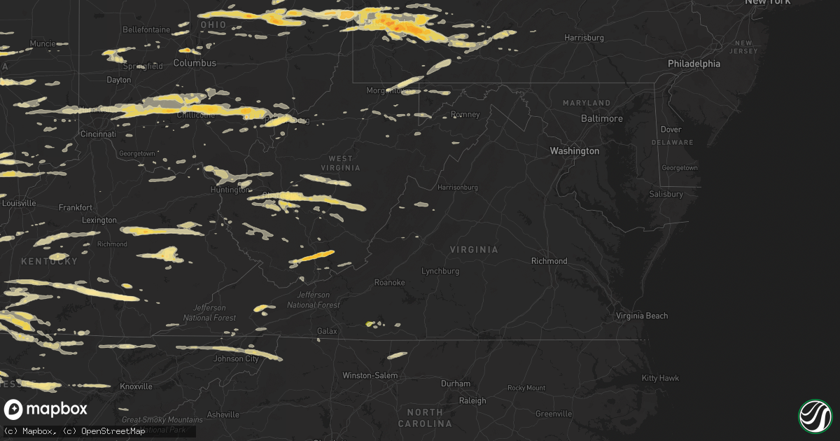
Hail Map in Virginia on March 23, 2011
Get this storm
March 23 map
$229
one time, instant access
Download today. No call, no setup
Keep the $229
Bought the map and want the full workflow? Apply the entire $229 to a subscription within 7 days. None of it is wasted.
Every map, not just this one
This buys you this map. Subscription and you get every map we run, in the markets you choose from a few cities to whole states to nationwide. Plus real-time alerts the moment a storm fires.
Contact data
Name, contact info, occupancy, even credit band for addresses in the footprint. You go from where it hit to who to call.
Become the source they trust
Unlimited branding weather history reports on demand. You already have the documented answer ready for the property owner, and you are the one who showed up with it.
Property data and RoofTrace estimates
Pull up any address you have got, its value and the exact code rules for that jurisdiction, straight from One Click Code. Then RoofTrace estimates the squares, pitch, and roof value, priced the way you price.
Storm reports in Virginia
Virginia
| Date | Description |
|---|---|
| 03/23/20116:45 PM CDT | Multiple trees down in luray |
| 03/23/20116:45 PM CDT | Trees and powerlines down |
| 03/23/20116:43 PM CDT | Trees knocked down along bixlers ferry road |
| 03/23/20116:42 PM CDT | Trees and powerlines down |
| 03/23/20116:41 PM CDT | Trees knocked down along bixlers ferry road |
| 03/23/20116:40 PM CDT | A local report indicates 63 MPH wind near 1 NE HAMBURG |
| 03/23/20116:40 PM CDT | Large tree knocked down from thunderstorm winds. Limbs of tree fell onto power lines and knocked them down near east point road and bethel church road |
| 03/23/20116:40 PM CDT | Two trees down. |
| 03/23/20116:40 PM CDT | Several trees... Up to 1 foot in diameter... Knocked down from thunderstorm winds north of rt 211 |
| 03/23/20116:39 PM CDT | Large tree knocked down from thunderstorm winds. Limbs of tree fell onto power lines and knocked them down near east point road and bethel church road |
| 03/23/20116:37 PM CDT | Trees knocked down onto a few vehicles in eqypt bend estates subdivision. No injuries. |
| 03/23/20116:35 PM CDT | Several trees... Up to 1 foot in diameter... Knocked down from thunderstorm winds north of rt 211 |
| 03/23/20116:35 PM CDT | Tree knocked down and damaging a gutter on side of a house in eqypt bend estates subdivision. |
| 03/23/20116:35 PM CDT | Thunderstorm winds knocked down powerlines near 3600 dry run road to the east-southeast of luray. |
| 03/23/20116:35 PM CDT | Trees knocked down along yaegers road. |
| 03/23/20116:30 PM CDT | Mature tree down and quarter size hail |
| 03/23/20116:30 PM CDT | Mature tree down and quarter size hail |
| 03/23/20116:29 PM CDT | Several trees... Up to 1 foot in diameter... Knocked down from thunderstorm winds north of rt 211 |
| 03/23/20116:29 PM CDT | Trees and powerlines down |
| 03/23/20116:29 PM CDT | Trees knocked down along bixlers ferry road |
| 03/23/20116:28 PM CDT | Large tree knocked down from thunderstorm winds. Limbs of tree fell onto power lines and knocked them down near east point road and bethel church road |
| 03/23/20116:27 PM CDT | Thunderstorm winds knocked down powerlines near 3600 dry run road to the east-southeast of luray. |
| 03/23/20116:27 PM CDT | Trees knocked down onto a few vehicles in eqypt bend estates subdivision. No injuries. |
| 03/23/20116:26 PM CDT | Tree knocked down and damaging a gutter on side of a house in eqypt bend estates subdivision. |
| 03/23/20116:26 PM CDT | Trees knocked down along yaegers road. |
| 03/23/20116:26 PM CDT | Power lines down across broadway avenue. |
| 03/23/20116:25 PM CDT | Svrl lrge trees snapped |
| 03/23/20116:20 PM CDT | Time estimated |
| 03/23/20116:20 PM CDT | Pwer lines down |
| 03/23/20116:13 PM CDT | Large tree down |
| 03/23/20116:03 PM CDT | Tree down |
| 03/23/20116:00 PM CDT | Trees and telephone wires down. |
| 03/23/20115:58 PM CDT | Tree down on house |
| 03/23/20115:40 PM CDT | Tree down near intersection of highway 360 and piney creek road |
| 03/23/20115:35 PM CDT | A couple of trees down at 8167 and 11000 block of james d hagood highway...highway 360 |
| 03/23/20115:32 PM CDT | Tree down across road |
| 03/23/20115:25 PM CDT | Tree down |
| 03/23/20115:25 PM CDT | Part of roof of trailer home blown off at 5225 kentuck rd. |
| 03/23/20115:25 PM CDT | Tree down on residence |
| 03/23/20115:25 PM CDT | Roof blown off residence |
| 03/23/20115:23 PM CDT | Power pole broken |
| 03/23/20115:20 PM CDT | Tree down |
| 03/23/20115:13 PM CDT | Tree down across road |
| 03/23/20115:09 PM CDT | Tree down |
| 03/23/20115:09 PM CDT | Tree down on power line |
| 03/23/20115:05 PM CDT | Tree down across callands rd |
| 03/23/20115:00 PM CDT | Numerous trees down...power lines down near intersection of mulberry road and sam lions road |
| 03/23/20115:00 PM CDT | Numerous trees down...power lines down near intersection of mulberry road and sam lions road |
| 03/23/20114:31 PM CDT | A local report indicates 1.00 inch wind near 12 NE STUART |
| 03/23/20114:30 PM CDT | Many branches down from thunderstorm wind gusts in heavy rain |
| 03/23/20114:07 PM CDT | Quarter size hail |
| 03/23/20112:25 PM CDT | Quarter size hail reported by public. |
| 03/22/20117:30 PM CDT | Trees down across county |
| 03/22/20117:15 PM CDT | Golfball size hail. Reported by dispatch. |
| 03/22/20117:10 PM CDT | Pwer lines down |
| 03/22/20117:05 PM CDT | Large branches down along state route 229 rixeyville road. |
| 03/22/20117:04 PM CDT | Trees and limbs down |
| 03/22/20117:00 PM CDT | Trees down |
| 03/22/20117:00 PM CDT | Multiple trees down in luray |
All States Impacted by Hail Map on March 23, 2011
Cities Impacted by Hail Map on March 23, 2011
- Ghent, WV
- Flat Top, WV
- Fort Gay, WV
- Sparta, TN
- Glasgow, KY
- Greensburg, KY
- Cave City, KY
- Hardyville, KY
- Edmonton, KY
- Gradyville, KY
- Knob Lick, KY
- Horse Cave, KY
- Columbia, KY
- Center, KY
- Indianapolis, IN
- Gallagher, WV
- Hansford, WV
- New Manchester, WV
- Toronto, OH
- New Cumberland, WV
- Chillicothe, OH
- Josephine, WV
- Jumping Branch, WV
- Herndon, WV
- Nimitz, WV
- Cool Ridge, WV
- Amigo, WV
- Welch, WV
- Stephenson, WV
- Odd, WV
- Pineville, WV
- Hinton, WV
- Lebanon, IN
- Sewickley, PA
- Pittsburgh, PA
- Reidsville, NC
- Madison, NC
- Okeana, OH
- Hamilton, OH
- Cedar Grove, IN
- Brookville, IN
- Oxford, OH
- West Harrison, IN
- Portage, PA
- East Freedom, PA
- Claysburg, PA
- Orbisonia, PA
- Fort Littleton, PA
- Hustontown, PA
- New Marshfield, OH
- Athens, OH
- Blount, WV
- Tad, WV
- Charleston, WV
- Romney, WV
- Underwood, IN
- Orleans, IN
- Nabb, IN
- Campbellsburg, IN
- Scottsburg, IN
- Salem, IN
- Marysville, IN
- Paoli, IN
- Henryville, IN
- Lexington, IN
- West Baden Springs, IN
- Yoder, IN
- Columbia City, IN
- Scottsville, KY
- Milan, IN
- Osgood, IN
- Sunman, IN
- Patrick Springs, VA
- Bassett, VA
- Stuart, VA
- Morgantown, WV
- Walker, WV
- Crossville, TN
- Pleasant Hill, TN
- Tipp City, OH
- Troy, OH
- Salem, WV
- Auburn, KY
- Russellville, KY
- Leechburg, PA
- Vandergrift, PA
- Hyde Park, PA
- Homer City, PA
- Ford City, PA
- Shelocta, PA
- Indiana, PA
- Apollo, PA
- Spring Church, PA
- Avonmore, PA
- Kingsport, TN
- Grafton, WV
- Bruceton Mills, WV
- Albright, WV
- Friendsville, MD
- Millersburg, OH
- Baltic, OH
- Kempton, IN
- Frankfort, IN
- Forest, IN
- Pioneer, TN
- Seanor, PA
- Windber, PA
- Hooversville, PA
- Hollsopple, PA
- Alum Bank, PA
- New Paris, PA
- Vancleve, KY
- Jackson, KY
- Campton, KY
- Beattyville, KY
- Erbacon, WV
- Frametown, WV
- Birch River, WV
- Cowen, WV
- Duck, WV
- Dille, WV
- Coolville, OH
- Little Hocking, OH
- Washington, WV
- Yolyn, WV
- Lake, WV
- Pecks Mill, WV
- Wharton, WV
- Lyburn, WV
- Henlawson, WV
- Stollings, WV
- Logan, WV
- Chapmanville, WV
- Amherstdale, WV
- Mount Juliet, TN
- Watertown, TN
- Hickman, TN
- Brush Creek, TN
- Alexandria, TN
- Gordonsville, TN
- Lebanon, TN
- Baxter, TN
- New Vienna, OH
- Wilmington, OH
- Sabina, OH
- Frankfort, OH
- Greenfield, OH
- Leesburg, OH
- Washington Court House, OH
- Stanton, KY
- Winchester, KY
- Ezel, KY
- Jeffersonville, KY
- Wellington, KY
- Frenchburg, KY
- Clay City, KY
- Denniston, KY
- South Bloomingville, OH
- McArthur, OH
- Creola, OH
- New Plymouth, OH
- Summersville, WV
- Nettie, WV
- Canvas, WV
- Eubank, KY
- Somerset, KY
- Science Hill, KY
- Bethelridge, KY
- Summersville, KY
- London, KY
- Lily, KY
- Canmer, KY
- Liberty, KY
- Munfordville, KY
- Nancy, KY
- Elk Horn, KY
- Windsor, KY
- Magnolia, KY
- Campbellsville, KY
- Dunnville, KY
- Knifley, KY
- Ligonier, PA
- New Florence, PA
- Derry, PA
- McKees Rocks, PA
- Austin, KY
- Woodburn, KY
- Bowling Green, KY
- Tompkinsville, KY
- Lucas, KY
- Alvaton, KY
- Etoile, KY
- Mount Hermon, KY
- Franklin, KY
- Fountain Run, KY
- Lebanon, VA
- Honaker, VA
- Rosedale, VA
- Aliquippa, PA
- Owensboro, KY
- Utica, KY
- Calhoun, KY
- Ambridge, PA
- Cedar Bluff, VA
- Cleveland, VA
- Gibsonia, PA
- Belle, WV
- Dover, OH
- Parkersburg, WV
- Belpre, OH
- Park City, KY
- Gambier, OH
- Danville, OH
- Howard, OH
- East Waterford, PA
- Shoals, IN
- Harned, KY
- Crofton, KY
- Hopkinsville, KY
- Cerulean, KY
- Sugarcreek, OH
- Stone Creek, OH
- Fresno, OH
- Reynolds Station, KY
- Falls Of Rough, KY
- Cloverport, KY
- Fordsville, KY
- Williamsville, VA
- West Augusta, VA
- Deerfield, VA
- Cassville, PA
- Mapleton Depot, PA
- Calvin, PA
- Huntingdon, PA
- Hunker, PA
- Manilla, IN
- Waldron, IN
- Milroy, IN
- Sturgis, KY
- Brinkhaven, OH
- Glenmont, OH
- Circleville, OH
- Stoutsville, OH
- Harriman, TN
- Buffalo, WV
- Milton, WV
- Ona, WV
- Duff, TN
- Lebanon, OH
- Middletown, OH
- Monroe, OH
- Mason, OH
- Willisburg, KY
- Berlin, PA
- Somerset, PA
- Rockwood, PA
- Garrett, PA
- Sparta, NC
- Ennice, NC
- Franklin Furnace, OH
- Pedro, OH
- Knightstown, IN
- Morristown, IN
- Greenfield, IN
- Arlington, IN
- Carthage, IN
- New Kensington, PA
- Morrow, OH
- New Holland, OH
- Carrollton, OH
- Hammondsville, OH
- Chester, WV
- Stratton, OH
- Salineville, OH
- Mechanicstown, OH
- Irondale, OH
- Georgetown, PA
- Amsterdam, OH
- Empire, OH
- Bergholz, OH
- Plain City, OH
- Columbus, OH
- Dublin, OH
- Powell, OH
- Shelbyville, IN
- Saint Paul, IN
- Follansbee, WV
- Weirton, WV
- Colliers, WV
- Oil Springs, KY
- Means, KY
- Mount Sterling, KY
- West Liberty, KY
- Salyersville, KY
- Hico, WV
- New Alexandria, PA
- Hannastown, PA
- Crabtree, PA
- Greensburg, PA
- Manor, PA
- Grapeville, PA
- Penn, PA
- Mckeesport, PA
- Latrobe, PA
- West Mifflin, PA
- Trafford, PA
- East McKeesport, PA
- Westmoreland City, PA
- Forbes Road, PA
- Glenshaw, PA
- Duquesne, PA
- Irwin, PA
- Ardara, PA
- East Pittsburgh, PA
- Wilmerding, PA
- Monroeville, PA
- North Versailles, PA
- Harrison City, PA
- Pitcairn, PA
- Claridge, PA
- Murrysville, PA
- Homestead, PA
- Braddock, PA
- Export, PA
- Dravosburg, PA
- Jeannette, PA
- Delmont, PA
- Bovard, PA
- Loyalhanna, PA
- Luxor, PA
- Turtle Creek, PA
- Coraopolis, PA
- Monroe, TN
- Livingston, TN
- Wheelersburg, OH
- Ironton, OH
- Kitts Hill, OH
- Willow Wood, OH
- Clinton, PA
- Tipton, IN
- Sharpsville, IN
- West Portsmouth, OH
- Blue Creek, OH
- Otway, OH
- Ellwood City, PA
- New Palestine, IN
- Larimer, PA
- Langeloth, PA
- Verona, PA
- Morgan, PA
- Youngstown, PA
- McDonald, PA
- Presto, PA
- Midway, PA
- Sturgeon, PA
- Slovan, PA
- New Derry, PA
- Oakdale, PA
- Bolivar, PA
- Clarksburg, PA
- Bradenville, PA
- Glassport, PA
- Blairsville, PA
- Adamsburg, PA
- Hostetter, PA
- Steubenville, OH
- Carnegie, PA
- Cuddy, PA
- Slickville, PA
- Saltsburg, PA
- Laughlintown, PA
- Allison Park, PA
- Burgettstown, PA
- Bulger, PA
- Mingo Junction, OH
- Imperial, PA
- Joffre, PA
- Boswell, PA
- Bridgeville, PA
- Springfield, KY
- Speedwell, TN
- Mineral City, OH
- Somerdale, OH
- New Philadelphia, OH
- Davidsville, PA
- Johnstown, PA
- Elton, PA
- Salix, PA
- Petroleum, WV
- Davisville, WV
- Waverly, WV
- Marietta, OH
- Guysville, OH
- Vienna, WV
- Cutler, OH
- Vincent, OH
- Ramsey, IN
- Depauw, IN
- New Salisbury, IN
- Milltown, IN
- Tazewell, VA
- Vilas, NC
- Butler, TN
- Elizabethton, TN
- Mountain City, TN
- Zionville, NC
- Hookstown, PA
- Williams, IN
- Vallonia, IN
- Brownstown, IN
- Tunnelton, IN
- Bedford, IN
- Medora, IN
- Mitchell, IN
- Seymour, IN
- Lancaster, KY
- Danville, KY
- Greencastle, IN
- Avon, IN
- Coatesville, IN
- Rockville, IN
- Roachdale, IN
- North Salem, IN
- Danville, IN
- Russellville, IN
- Plainfield, IN
- Bainbridge, IN
- Baker, WV
- Moorefield, WV
- Kingman, IN
- Veedersburg, IN
- Covington, IN
- Waynetown, IN
- Crawfordsville, IN
- Hillsboro, IN
- Apple Creek, OH
- Bunola, PA
- Venetia, PA
- Monongahela, PA
- Finleyville, PA
- Monticello, KY
- Stearns, KY
- Thornton, WV
- Moatsville, WV
- Red Boiling Springs, TN
- Glasgow, WV
- Hernshaw, WV
- East Bank, WV
- Winifrede, WV
- Cabin Creek, WV
- Cedar Grove, WV
- London, WV
- Pratt, WV
- Comfort, WV
- Hugheston, WV
- Vine Grove, KY
- Radcliff, KY
- Thorntown, IN
- Jamestown, IN
- Nelsonville, OH
- Stewart, OH
- Midland, OH
- Londonderry, OH
- Chauncey, OH
- Blanchester, OH
- Goshen, OH
- Kingston, OH
- Pleasant Plain, OH
- Millfield, OH
- Amesville, OH
- Oregonia, OH
- Laurelville, OH
- Martinsville, OH
- Logan, OH
- Clarksville, OH
- The Plains, OH
- Lebanon, KY
- Westerville, OH
- Custer, KY
- Darlington, IN
- Moss, TN
- Whitleyville, TN
- Celina, TN
- Clairton, PA
- Buena Vista, PA
- Elizabeth, PA
- Fredericksburg, OH
- Dalton, OH
- Navarre, OH
- Brewster, OH
- Dundee, OH
- Mount Eaton, OH
- Massillon, OH
- Greensburg, IN
- Marysville, OH
- Rogersville, TN
- Sneedville, TN
- Thorn Hill, TN
- Gibbon Glade, PA
- Farmington, PA
- West Hamlin, WV
- Indore, WV
- Pond Gap, WV
- Fenwick, WV
- Belva, WV
- Clendenin, WV
- Hamlin, WV
- Swiss, WV
- Dunbar, WV
- Lizemores, WV
- Renick, WV
- Saint Albans, WV
- Sod, WV
- Elkview, WV
- Craigsville, WV
- Tornado, WV
- Dixie, WV
- South Charleston, WV
- Hurricane, WV
- Alum Creek, WV
- Richwood, WV
- Bickmore, WV
- Manchester, KY
- James Creek, PA
- East Bernstadt, KY
- Bradford, OH
- Covington, OH
- Pleasant Hill, OH
- Garfield, KY
- Irvington, KY
- La Follette, TN
- Gravel Switch, KY
- Rineyville, KY
- Elizabethtown, KY
- West Point, KY
- Noblesville, IN
- Westfield, IN
- Beech Grove, IN
- West Elizabeth, PA
- Mahaffey, PA
- Hardinsburg, KY
- Kittanning, PA
- Rossiter, PA
- Rochester Mills, PA
- Punxsutawney, PA
- Glen Campbell, PA
- Dayton, PA
- Smicksburg, PA
- Rushville, IN
- Deputy, IN
- Durham, NC
- Belington, WV
- Morgantown, KY
- Central City, PA
- Stoystown, PA
- Friedens, PA
- Wampum, PA
- New Galilee, PA
- Gamaliel, KY
- Dupont, IN
- Austin, IN
- Lynchburg, OH
- South Heights, PA
- Leetsdale, PA
- Dellroy, OH
- Baden, PA
- Wexford, PA
- Crescent, PA
- Sherrodsville, OH
- Strasburg, OH
- Rowlesburg, WV
- Tunnelton, WV
- Clarksburg, OH
- Sheridan, IN
- Lapel, IN
- Anderson, IN
- South Lebanon, OH
- Williamsport, OH
- Daleville, IN
- Yorktown, IN
- Oneida, TN
- Tazewell, TN
- Helenwood, TN
- New Tazewell, TN
- Coshocton, OH
- Killbuck, OH
- Markleysburg, PA
- Lake Lynn, PA
- West Chester, OH
- Kings Mills, OH
- Albany, OH
- Waynesville, OH
- Loveland, OH
- Metamora, IN
- Oldenburg, IN
- Rockbridge, OH
- Maineville, OH
- Trenton, OH
- Batesville, IN
- Cincinnati, OH
- Fountaintown, IN
- Harmony, PA
- Portersville, PA
- Prospect, PA
- Albany, KY
- Sunbury, OH
- Springfield, OH
- Crothersville, IN
- Delaware, OH
- Barbourville, KY
- Griffithsville, WV
- Reynoldsville, PA
- Mount Sterling, OH
- East Rochester, OH
- Minerva, OH
- Homeworth, OH
- Beloit, OH
- Salem, OH
- Mount Pleasant, PA
- Madison, PA
- Ruffs Dale, PA
- Youngwood, PA
- New Stanton, PA
- Fletcher, OH
- Piqua, OH
- Casstown, OH
- Freetown, IN
- Norman, IN
- Williamsburg, OH
- Mount Orab, OH
- Batavia, OH
- Bardstown, KY
- New Castle, PA
- Pomeroy, OH
- Shade, OH
- Aurora, WV
- Terra Alta, WV
- English, IN
- Paris Crossing, IN
- Commiskey, IN
- Irvine, KY
- River, KY
- Smithfield, PA
- Point Marion, PA
- Bobtown, PA
- Dilliner, PA
- New Geneva, PA
- Greensboro, PA
- Bristol, TN
- Bluff City, TN
- Lerona, WV
- Princeton, WV
- Bennington, IN
- Dillsboro, IN
- Rising Sun, IN
- Aurora, IN
- Bainbridge, OH
- Hillsboro, OH
- Butler, OH
- Bellville, OH
- Lucas, OH
- Perrysville, OH
- Summer Shade, KY
- Burkesville, KY
- Beaumont, KY
- Oakland, MD
- Left Hand, WV
- Wallback, WV
- Clay, WV
- Procious, WV
- Amma, WV
- Ivydale, WV
- Newton, WV
- Ashland, KY
- Glenwood, WV
- Crown City, OH
- Lesage, WV
- Ashton, WV
- Leon, WV
- Liberty, WV
- South Point, OH
- Chesapeake, OH
- Proctorville, OH
- Fraziers Bottom, WV
- Scottown, OH
- Red House, WV
- Johnson City, TN
- Worthville, KY
- Sanders, KY
- Church Hill, TN
- Greenville, IN
- Georgetown, IN
- Palmyra, IN
- Princeton, KY
- Osterburg, PA
- Walhonding, OH
- Warsaw, OH
- Ashville, OH
- Shepherdsville, KY
- Clarks Hill, IN
- Lafayette, IN
- Hanover, IN
- Urbana, OH
- Dennison, OH
- Uhrichsville, OH
- Midvale, OH
- Lowell, OH
- Lower Salem, OH
- Wellsville, OH
- Cardington, OH
- Magnolia, OH
- Loudonville, OH
- Newell, WV
- Mount Gilead, OH
- Big Prairie, OH
- Fredericktown, OH
- Glouster, OH
- Harrodsburg, KY
- Woolwine, VA
- Smithville, TN
- Ghent, KY
- Bolivar, OH
- Fall Branch, TN
- Surgoinsville, TN
- Jonesborough, TN
- Piney Flats, TN
- Milton, IN
- Connersville, IN
- Falmouth, IN
- Creekside, PA
- Todd, NC
- Trade, TN
- Watauga, TN
- Boone, NC
- Winchester, OH
- Radnor, OH
- Frostburg, MD
- Grantsville, MD
- Barton, MD
- Lonaconing, MD
- Accident, MD
- Darlington, PA
- Enon Valley, PA
- Adolphus, KY
- Sharon Grove, KY
- Lafayette, TN
- Lewisburg, KY
- Holland, KY
- Elkton, KY
- Hestand, KY
- South Vienna, OH
- Dover, KY
- Ripley, OH
- Maysville, KY
- Guilford, IN
- Cairnbrook, PA
- Jerome, PA
- Springdale, PA
- Cheswick, PA
- Mount Vernon, OH
- Oakmont, PA
- Lookout, WV
- Edmond, WV
- Home, PA
- West Union, OH
- Bristol, VA
- Hiltons, VA
- Ashford, WV
- Waterfall, PA
- Three Springs, PA
- Eddyville, KY
- Ostrander, OH
- Byrdstown, TN
- Jamestown, TN
- Pall Mall, TN
- Silver Point, TN
- Madison, IN
- Cassandra, PA
- Lilly, PA
- Canal Fulton, OH
- Loogootee, IN
- Ridgeview, WV
- Nellis, WV
- New Carlisle, OH
- Stockport, OH
- Waterford, OH
- Fleming, OH
- Elkfork, KY
- Ravenswood, WV
- Marengo, IN
- Saltville, VA
- Greenville, WV
- Lindside, WV
- Ballard, WV
- Union, WV
- Martinsville, VA
- Dana, IN
- Booneville, KY
- Negley, OH
- West Milton, OH
- Ludlow Falls, OH
- Taylorsville, KY
- Wilmore, PA
- Ebensburg, PA
- Mineral Point, PA
- Summerhill, PA
- Frazeysburg, OH
- Falls Mills, VA
- Freeman, WV
- Bramwell, WV
- Bluefield, VA
- Bluefield, WV
- Pocahontas, VA
- Prospect, OH
- Richwood, OH
- Old Hickory, TN
- Bloomfield, KY
- New Haven, KY
- Salvisa, KY
- Arcadia, IN
- Cicero, IN
- North Lewisburg, OH
- Isonville, KY
- Nicholasville, KY
- Wilmore, KY
- Harrisville, WV
- Rockwood, TN
- Saint Paris, OH
- Arcanum, OH
- Conover, OH
- Staffordsville, KY
- Flatgap, KY
- Martha, KY
- Keaton, KY
- Sandy Hook, KY
- Todd, PA
- Martinsburg, PA
- Saxton, PA
- Windfall, IN
- Elwood, IN
- Tollesboro, KY
- Vanceburg, KY
- Flemingsburg, KY
- Greenback, TN
- Maryville, TN
- Advance, IN
- Belleville, WV
- Rockport, WV
- Russell Springs, KY
- Paducah, KY
- Dunlow, WV
- Genoa, WV
- Gate City, VA
- Beaver, WV
- Rutland, OH
- South Shore, KY
- Woodstock, OH
- Acme, PA
- Oakdale, TN
- Carrollton, KY
- Herminie, PA
- Lowber, PA
- West Newton, PA
- Sutersville, PA
- Alpine, TN
- Allons, TN
- Abingdon, VA
- Saint Catharine, KY
- Shinnston, WV
- Bridgeport, WV
- Johnstown, OH
- Lisbon, OH
- Hanoverton, OH
- Leetonia, OH
- Beaver, OH
- Larwill, IN
- Bradfordsville, KY
- Perryville, KY
- Stout, OH
- Lebanon Junction, KY
- Slab Fork, WV
- Lester, WV
- Hopedale, OH
- Jewett, OH
- Cookeville, TN
- Racine, WV
- Sumerco, WV
- Yawkey, WV
- Costa, WV
- Cecilia, KY
- Reedsville, WV
- Independence, WV
- Kingwood, WV
- Newburg, WV
- Mount Nebo, WV
- Nallen, WV
- Quinwood, WV
- Charmco, WV
- Waverly, OH
- Hollidaysburg, PA
- Darragh, PA
- Hambleton, WV
- Davis, WV
- Beaver Falls, PA
- Galena, OH
- Harlan, KY
- Cawood, KY
- Pathfork, KY
- Lewis Center, OH
- Bedford, KY
- French Lick, IN
- Milton, KY
- Pekin, IN
- Burlington, WV
- Purgitsville, WV
- Waverly, KY
- Corydon, KY
- Morganfield, KY
- Alkol, WV
- Eskdale, WV
- Drybranch, WV
- Lexington, VA
- Farmland, IN
- Modoc, IN
- Lancaster, OH
- Tarlton, OH
- Amanda, OH
- Sugar Grove, OH
- Culloden, WV
- Hilham, TN
- Rockfield, KY
- Newcomerstown, OH
- Port Washington, OH
- Selma, IN
- Auburntown, TN
- Liberty, TN
- Oak Ridge, TN
- Crab Orchard, TN
- Oliver Springs, TN
- Clarksburg, WV
- Confluence, PA
- Fort Hill, PA
- Markleton, PA
- Wellston, OH
- Hamden, OH
- Eglon, WV
- Mount Vernon, KY
- Brodhead, KY
- Claypool, IN
- East Palestine, OH
- Warm Springs, VA
- Swoope, VA
- Cannelburg, IN
- New Enterprise, PA
- Peytona, WV
- Foster, WV
- Coxs Creek, KY
- Stokesdale, NC
- Sutton, WV
- Woodbury, PA
- Broad Top, PA
- Rillton, PA
- Fishertown, PA
- Bowerston, OH
- Greenock, PA
- Gnadenhutten, OH
- Imler, PA
- Scio, OH
- Bethel Park, PA
- Tuscarawas, OH
- Beach City, OH
- Schellsburg, PA
- Roaring Spring, PA
- Edison, OH
- Sidman, PA
- Dudley, PA
- Mooresburg, TN
- Junction, IL
- Elizabethtown, IL
- Cave In Rock, IL
- Louisa, KY
- Clayhole, KY
- Granville, WV
- Campbellsburg, KY
- Turners Station, KY
- Owenton, KY
- Walton, WV
- Mill Run, PA
- Washington, IN
- Brownsburg, IN
- Manchester, OH
- Milford, OH
- Garrison, KY
- Duncansville, PA
- Parker City, IN
- Winchester, IN
- Fieldale, VA
- New Creek, WV
- Versailles, KY
- Fredericksburg, IN
- Lucasville, OH
- McDermott, OH
- Portsmouth, OH
- Dingess, WV
- Harts, WV
- New Ross, IN
- Yosemite, KY
- Waynesburg, KY
- Hawesville, KY
- Philpot, KY
- Whitesville, KY
- Victor, WV
- Ansted, WV
- Russellton, PA
- Tarentum, PA
- Peebles, OH
- Kuttawa, KY
- Perrysville, IN
- Rogers, OH
- Clifton Forge, VA
- Centerburg, OH
- New Eagle, PA
- Cross Plains, IN
- Versailles, IN
- Lumberport, WV
- Six Mile Run, PA
- Blanch, NC
- Yanceyville, NC
- Cairo, WV
- Saint Marys, WV
- Ellenboro, WV
- Armagh, PA
- Wittensville, KY
- Sitka, KY
- Sadieville, KY


