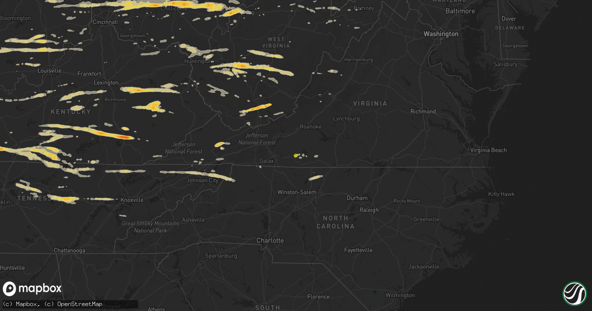
Hail Map on March 23, 2011
Get this storm
March 23 map
$229
one time, instant access
Download today. No call, no setup
Keep the $229
Bought the map and want the full workflow? Apply the entire $229 to a subscription within 7 days. None of it is wasted.
Every map, not just this one
This buys you this map. Subscription and you get every map we run, in the markets you choose from a few cities to whole states to nationwide. Plus real-time alerts the moment a storm fires.
Contact data
Name, contact info, occupancy, even credit band for addresses in the footprint. You go from where it hit to who to call.
Become the source they trust
Unlimited branding weather history reports on demand. You already have the documented answer ready for the property owner, and you are the one who showed up with it.
Property data and RoofTrace estimates
Pull up any address you have got, its value and the exact code rules for that jurisdiction, straight from One Click Code. Then RoofTrace estimates the squares, pitch, and roof value, priced the way you price.
States Impacted by Hail Map on March 23, 2011
Storm reports
Maryland
| Date | Description |
|---|---|
| 03/23/20115:30 PM CDT | Nickel and quarter size |
| 03/23/20115:15 PM CDT | Several trees down |
| 03/23/20113:36 PM CDT | A local report indicates 1.00 inch wind near REDHOUSE |
Georgia
| Date | Description |
|---|---|
| 03/22/201110:12 PM CDT | Pickens county 911 reports widespread tree damage in county along with numerous powerlines down and some minor roof damage. |
| 03/22/201110:12 PM CDT | Nws personnel and the pickens em surveyed damage and damage photos and determined that a swath of strong straight-line winds up to 75 mph occurred. Two large chicken ho |
| 03/22/20119:30 PM CDT | Gordon county 911 relayed a report of a tree down on red bud rd. Near oakman. |
| 03/22/20119:30 PM CDT | Walker county 911 relayed a report of a tree down in southwest lafayette. |
| 03/22/20119:20 PM CDT | Walker county 911 relayed a report of a tree down on highway 193 and akins road. |
| 03/22/20118:57 PM CDT | Dade county 911 relayed a report of a tree down on morganville loop road. |
Tennessee
| Date | Description |
|---|---|
| 03/23/20116:54 PM CDT | Damage began near the intersection of indian mound road and old smithville highway. Hundreds of trees were uprooted or snapped along a nearly continuous 9 mile path. Th |
| 03/23/20116:41 PM CDT | A local report indicates 1.00 inch wind near 3 W JAMESTOWN |
| 03/23/20116:40 PM CDT | Structure roof damage on dooley road |
| 03/23/20116:35 PM CDT | Trained spotter rpt quarter sized hail. |
| 03/23/20116:29 PM CDT | Quarter sized hail reported near monroe. |
| 03/23/20116:20 PM CDT | Barn blown down on old alexanria road. Ema en route to survey damage. |
| 03/23/20116:20 PM CDT | Roof blown off a home on haley road. |
| 03/23/20116:19 PM CDT | Hundreds of trees were uprooted or snapped along a nearly continuous 6 mile path. Several homes suffered significant roof damage...and a couple barns and outbuildings w |
| 03/23/20115:45 PM CDT | Trees down in the butler area reported by hwy dept and tdot. |
| 03/23/20115:42 PM CDT | Reported near west wilson school on lebanon road. |
| 03/23/20114:00 PM CDT | Quarter size hail reported by dispatch on highway 91. |
| 03/23/20113:45 PM CDT | Couple trees down. |
| 03/23/20112:32 PM CDT | Quarter size hail on highway 70n. |
| 03/23/20112:10 PM CDT | Public rpt of broken car windows |
| 03/23/20112:00 PM CDT | Public rpt of broken car windows |
| 03/23/201112:20 AM CDT | Quarter size hail reported by spotter. |
| 03/22/20118:57 PM CDT | Possible tornado reported by ham...multiple trees down and possible injuries on janeway rd. |
| 03/22/20118:55 PM CDT | *** 1 inj *** possible tornado...3 story house destroyed and roof blown off another house. |
| 03/22/20118:50 PM CDT | Possible tornado reported by dispatch...mutiple power lines and trees down on hwy 95 also damage to roof of house. |
| 03/22/20118:50 PM CDT | Ef-3 tornado with maximum winds of 140 mph and maximum path width of 500 yards with a 4.5 mile length. |
| 03/22/20118:35 PM CDT | One tree down on river devide rd. Reported by dispatch. |
| 03/22/20118:35 PM CDT | One tree down on the spur-hwy 441 between gatlinburg and pigeon forge. Reported by dispatch. |
| 03/22/20118:34 PM CDT | One tree down in del rio. Reported by dispatch. |
| 03/22/20118:20 PM CDT | One tree down on hwy 346 in surgoinsville. Reported by dispatch. |
| 03/22/20118:20 PM CDT | One tree down on ebbing flowing springs rd. Reported by dispatch. |
| 03/22/20118:10 PM CDT | One tree down at spring hill and one tree down at buffet mills. Reported by dispatch. |
| 03/22/20118:05 PM CDT | One tree down at washburn. Reported by dispatch. |
| 03/22/20118:05 PM CDT | One tree down at blaine. Reported by dispatch. |
| 03/22/20117:50 PM CDT | Trees reported down in hillsboro. |
| 03/22/20117:45 PM CDT | Tree reported down on gattistown road. Substation was also hit resulting in 781 residents briefly without power. |
| 03/22/20117:15 PM CDT | Several trees down. |
| 03/22/20117:10 PM CDT | Trees down in christiana. |
| 03/22/20117:04 PM CDT | A damage survey confirmed an ef-0 tornado with 70 to 80 mph winds touched down 2 miles west of christiana. Path was 1 mile long and 50 yards wide. Damage occurred on wa |
| 03/22/20117:03 PM CDT | Damage occurred on walnut grove road near hwy 231...some trees were uprooted and a small portion of shingles were removed from a few homes. A couple of outbuildings wer |
| 03/22/20117:01 PM CDT | Homes off foundation and trailer destroyed on will thompson road. Injuries reported. Possible tornado. |
| 03/22/20117:01 PM CDT | Trailer destroyed. Trees and power lines down. Possible tornado. |
Ohio
| Date | Description |
|---|---|
| 03/23/20114:27 PM CDT | 55mph gust reported...sheeting falling off houses...branches off trees...and several trees falling down |
| 03/23/20114:15 PM CDT | Town of willow wood |
| 03/23/20114:00 PM CDT | Barn lifted off of ground with concrete...outbuilding picked up and blown across street...roof blown off home...numerous trees and power lines down |
| 03/23/20113:55 PM CDT | A local report indicates 1.00 inch wind near 2 SSW LITTLE HOCKING |
| 03/23/20113:42 PM CDT | Numerous trees down and power outages. |
| 03/23/20113:42 PM CDT | *** 1 fatal *** corrected report. A woman in her 20s was killed by a falling tree while she was camping at the shawnee state forest. Earlier reports of a child killed a |
| 03/23/20113:40 PM CDT | Several trees reported down around athens township |
| 03/23/20113:38 PM CDT | *** 1 fatal *** a tree fell on a child who was inside a tent at a boy scout camp in the shawnee state forest. Fatality time is estimated. Corrected time from previous r |
| 03/23/20113:35 PM CDT | Power lines down on big run road just east of sr 23. |
| 03/23/20113:34 PM CDT | Trees and power lines down |
| 03/23/20113:34 PM CDT | House trailer being towed blown over |
| 03/23/20113:33 PM CDT | A local report indicates 1.00 inch wind near SALINEVILLE |
| 03/23/20113:30 PM CDT | A local report indicates 1.25 inch wind near IRONDALE |
| 03/23/20113:28 PM CDT | A local report indicates 1.00 inch wind near COSHOCTON |
| 03/23/20113:27 PM CDT | 55mph gust reported...sheeting falling off houses...branches off trees...and several trees falling down |
| 03/23/20113:25 PM CDT | Penny size hail also reported. |
| 03/23/20113:20 PM CDT | A local report indicates 1.75 inch wind near BALTIC |
| 03/23/20113:15 PM CDT | Spotter had yard covered with golf ball sized hail...reported damage to car |
| 03/23/20113:13 PM CDT | A local report indicates 1.00 inch wind near 2 S COLUMBIANA |
| 03/23/20113:10 PM CDT | A local report indicates 60 MPH wind near RUSSELLVILLE |
| 03/23/20113:10 PM CDT | A local report indicates 65 MPH wind near CHERRY FORK |
| 03/23/20113:08 PM CDT | A commercial barns entire frame was blown 50 feet from its foundation. |
| 03/23/20113:05 PM CDT | Marble to golf ball sized hail |
| 03/23/20113:05 PM CDT | Possible collapse of a greenhouse. Injuries unknown at this time. |
| 03/23/20113:03 PM CDT | Trees downed in the fairfax area. |
| 03/23/20113:02 PM CDT | *** 1 inj *** a greenhouse collapsed near state route 73 in berrysville. One injury occurred when a woman was trapped inside. |
| 03/23/20113:01 PM CDT | Roof blown off a garage on fair ridge road. |
| 03/23/20113:01 PM CDT | Nickel to quarter sized hail for about 5-10 minutes. |
| 03/23/20113:00 PM CDT | A local report indicates 1.00 inch wind near 2 N CREOLA |
| 03/23/20113:00 PM CDT | A local report indicates 1.00 inch wind near HANOVERTON |
| 03/23/20112:55 PM CDT | Spotter measured 1.75 inch hail. |
| 03/23/20112:55 PM CDT | A local report indicates 1.50 inch wind near DOVER |
| 03/23/20112:50 PM CDT | Near burgholtz |
| 03/23/20112:48 PM CDT | Power pole blown down near us 22 and miami trace road. |
| 03/23/20112:44 PM CDT | A local report indicates 1.25 inch wind near MARTINSVILLE |
| 03/23/20112:44 PM CDT | A local report indicates 1.25 inch wind near BERLIN |
| 03/23/20112:40 PM CDT | Large branches broken. |
| 03/23/20112:39 PM CDT | Between dry run road and state route 180. |
| 03/23/20112:38 PM CDT | A local report indicates 1.75 inch wind near ADELPHI |
| 03/23/20112:36 PM CDT | Dime to quarter size hail |
| 03/23/20112:35 PM CDT | A local report indicates 1.00 inch wind near TROY |
| 03/23/20112:35 PM CDT | A local report indicates 1.00 inch wind near 2 NE MILLERSBURG |
| 03/23/20112:34 PM CDT | A local report indicates 1.75 inch wind near GREENFIELD |
| 03/23/20112:34 PM CDT | A local report indicates 1.00 inch wind near 2 E SUMMITVILLE |
| 03/23/20112:31 PM CDT | A local report indicates 1.00 inch wind near STEUBENVILLE |
| 03/23/20112:31 PM CDT | A local report indicates 1.75 inch wind near 2 NNE CHILLICOTHE |
| 03/23/20112:30 PM CDT | A local report indicates 1.00 inch wind near NORTH CANTON |
| 03/23/20112:26 PM CDT | A local report indicates 1.25 inch wind near FREDERICKTOWN |
| 03/23/20112:21 PM CDT | A local report indicates 1.00 inch wind near 3 N CLARKSVILLE |
| 03/23/20112:20 PM CDT | A local report indicates 1.00 inch wind near LOUDONVILLE |
| 03/23/20112:18 PM CDT | *** 1 inj *** a large tree was blown down on a car. One person in the car was injured. |
| 03/23/20112:18 PM CDT | A local report indicates 1.50 inch wind near FRANKFORT |
| 03/23/20112:15 PM CDT | A local report indicates 1.25 inch wind near 1 S COVINGTON |
| 03/23/20112:12 PM CDT | A local report indicates 1.75 inch wind near ASHVILLE |
| 03/23/20112:08 PM CDT | A local report indicates 1.00 inch wind near 2 NW BUTLER |
| 03/23/20112:05 PM CDT | Hail at least the size of quarters. Time and size of hail estimated. |
| 03/23/20112:05 PM CDT | A local report indicates 1.00 inch wind near PROSPECT |
| 03/23/20112:04 PM CDT | A local report indicates 1.75 inch wind near GREENFIELD |
| 03/23/20111:43 PM CDT | A local report indicates 1.00 inch wind near WASHINGTON COURT HOUSE |
| 03/23/20111:35 PM CDT | A local report indicates 1.00 inch wind near MOUNT GILEAD |
| 03/23/20111:29 PM CDT | A local report indicates 1.25 inch wind near 2 N BLANCHESTER |
| 03/23/20111:07 PM CDT | 2 trees down. |
| 03/23/20111:02 PM CDT | A local report indicates 1.00 inch wind near 3 ENE SHARONVILLE |
| 03/22/201110:50 PM CDT | A local report indicates 1.00 inch wind near PROCTORVILLE |
| 03/22/20119:54 PM CDT | Nickel to quarter size |
| 03/22/20119:52 PM CDT | A local report indicates 1.00 inch wind near 2 N BENTONVILLE |
North Carolina
| Date | Description |
|---|---|
| 03/23/20116:45 PM CDT | 2 trees down across tabbs creek road near 158 and 85. |
| 03/23/20116:27 PM CDT | Tree came down across a road and brought power lines with it near the corner of little river church rd and mary hall rd |
| 03/23/20116:14 PM CDT | 18 inch diameter tree down across the road near the corner of hurdle mills rd and wheelers church rd. |
| 03/23/20115:55 PM CDT | Power lines down |
| 03/23/20115:40 PM CDT | Radio tower fell over on power lines and a building on madison street near business u.s. 29 |
| 03/23/20115:27 PM CDT | Tree down along highway 8 |
| 03/23/20115:18 PM CDT | Powerlines reported down in the community of stoneville. |
| 03/23/20115:14 PM CDT | Tree down near seven island road and damascas road |
| 03/23/20115:06 PM CDT | Tree down near collinstown road and electric plant road |
| 03/23/20115:03 PM CDT | Tree down |
| 03/23/20115:00 PM CDT | Numerous trees and power lines down |
| 03/23/20114:46 PM CDT | Power lines down |
| 03/23/20114:30 PM CDT | A local report indicates 1.00 inch wind near 1 NNW BOONE |
| 03/23/201112:30 AM CDT | Time estimated. Substantial straight line wind damage in the comfort area comfirmed by nws storm survey. Barn destroyed and several 80 ft tall trees blown down. Winds e |
| 03/22/201110:03 PM CDT | Hail the size of quarters on route 14 north of wake forest. |
| 03/22/20119:15 PM CDT | Tree down in backyard on kingsmill dr in oak valley golf community. |
| 03/22/20119:10 PM CDT | Several tree limbs down in yard and down the street. |
| 03/22/20119:08 PM CDT | Tree down on highway 65 north in germantown |
| 03/22/20119:08 PM CDT | Tree down on dave smith road |
| 03/22/20119:05 PM CDT | Tree down on gun poole road and highway 119 |
| 03/22/20119:05 PM CDT | Tree down on highway 89 and pyrtle road |
| 03/22/20119:00 PM CDT | Tree down on highway 704 west |
| 03/22/20119:00 PM CDT | Tree down on west dalton road |
| 03/22/20119:00 PM CDT | Tree down on tise lane and trinity church road |
| 03/22/20117:55 PM CDT | A local report indicates 1.00 inch wind near WENTWORTH |
| 03/22/20117:52 PM CDT | Multiple trees down and screen door blown off house on cecil rd near archer lodge. |
| 03/22/20117:13 PM CDT | Tree down partially blocking the road at the 1100 block of hwy 561 |
| 03/22/20117:07 PM CDT | Tree down on a house and a car on harris point way. |
Pennsylvania
| Date | Description |
|---|---|
| 03/23/20116:00 PM CDT | Trees down |
| 03/23/20115:45 PM CDT | Several trees down |
| 03/23/20115:10 PM CDT | A local report indicates 60 MPH wind near MEYERSDALE |
| 03/23/20115:00 PM CDT | Several trees and power lines down |
| 03/23/20115:00 PM CDT | Trees down along route 31 |
| 03/23/20114:55 PM CDT | In pleasantville along rte 56 |
| 03/23/20114:45 PM CDT | Roof damage |
| 03/23/20114:45 PM CDT | A local report indicates 1.00 inch wind near OGLETOWN |
| 03/23/20114:37 PM CDT | Trees down in realton area. |
| 03/23/20114:33 PM CDT | Trees and power lines down. |
| 03/23/20114:32 PM CDT | A local report indicates 1.00 inch wind near WESTMORELAND CITY |
| 03/23/20114:30 PM CDT | Numerous trees and power lines down |
| 03/23/20114:21 PM CDT | Oakland section |
| 03/23/20114:20 PM CDT | A local report indicates 1.00 inch wind near LINCOLN PLACE |
| 03/23/20114:18 PM CDT | A local report indicates 1.00 inch wind near PITTSBURGH |
| 03/23/20114:17 PM CDT | Parkway north hazlet st exit |
| 03/23/20114:16 PM CDT | Oakland section |
| 03/23/20114:15 PM CDT | A local report indicates 1.75 inch wind near GREEN TREE |
| 03/23/20114:15 PM CDT | A local report indicates 1.00 inch wind near ROSS TOWNSHIP |
| 03/23/20114:14 PM CDT | Lawson heights |
| 03/23/20114:12 PM CDT | A local report indicates 1.75 inch wind near GREEN TREE |
| 03/23/20114:10 PM CDT | A local report indicates 1.75 inch wind near LATROBE |
| 03/23/20114:05 PM CDT | A local report indicates 1.25 inch wind near WEXFORD |
| 03/23/20114:04 PM CDT | A local report indicates 1.75 inch wind near 1 N WHITNEY |
| 03/23/20114:03 PM CDT | A local report indicates 1.75 inch wind near LATROBE |
| 03/23/20114:03 PM CDT | A local report indicates 1.25 inch wind near GREENSBURG |
| 03/23/20114:00 PM CDT | Nws office |
| 03/23/20114:00 PM CDT | Fort allen area 10 to 20 homes with roof damage. |
| 03/23/20113:59 PM CDT | A local report indicates 1.00 inch wind near LATROBE |
| 03/23/20113:57 PM CDT | A local report indicates 1.25 inch wind near LATROBE |
| 03/23/20113:57 PM CDT | Westmoreland mall |
| 03/23/20113:57 PM CDT | A local report indicates 1.00 inch wind near SOMERSET |
| 03/23/20113:56 PM CDT | A local report indicates 1.75 inch wind near LATROBE |
| 03/23/20113:53 PM CDT | A local report indicates 1.75 inch wind near GREENSBORO |
| 03/23/20113:52 PM CDT | A local report indicates 1.00 inch wind near 3 S HOOKSTOWN |
| 03/23/20113:50 PM CDT | A local report indicates 2.00 inch wind near GREENSBURG |
| 03/23/20113:46 PM CDT | Grapeville area |
| 03/23/20113:45 PM CDT | A local report indicates 1.75 inch wind near SALTSBURG |
| 03/23/20113:45 PM CDT | A local report indicates 1.00 inch wind near SOMERSET |
| 03/23/20113:45 PM CDT | Ef2 tornado confirmed in hempfield twp westmoreland co |
| 03/23/20113:44 PM CDT | A local report indicates 1.75 inch wind near IRWIN |
| 03/23/20113:42 PM CDT | A local report indicates 1.75 inch wind near 2 S IRWIN |
| 03/23/20113:38 PM CDT | A local report indicates 1.50 inch wind near IRWIN |
| 03/23/20113:38 PM CDT | Green oak area. Gust to 60 mph. Trees down. |
| 03/23/20113:36 PM CDT | A local report indicates 1.00 inch wind near AVONMORE |
| 03/23/20113:35 PM CDT | A local report indicates 1.25 inch wind near MONROEVILLE |
| 03/23/20113:35 PM CDT | A local report indicates 1.00 inch wind near SOMERSET |
| 03/23/20113:30 PM CDT | A local report indicates 1.00 inch wind near TRAFFORD |
| 03/23/20113:30 PM CDT | A local report indicates 1.00 inch wind near MCKEESPORT |
| 03/23/20113:20 PM CDT | A local report indicates 1.00 inch wind near WEXFORD |
| 03/23/20113:19 PM CDT | A local report indicates 1.00 inch wind near ALIQUIPPA |
| 03/23/20113:10 PM CDT | A local report indicates 1.00 inch wind near BRIDGEVILLE |
| 03/23/20113:06 PM CDT | A local report indicates 1.00 inch wind near IMPERIAL |
| 03/23/20113:06 PM CDT | A local report indicates 1.00 inch wind near ROBINSON TOWNSHIP |
| 03/23/20113:00 PM CDT | A local report indicates 1.00 inch wind near FARMINGTON |
| 03/23/20113:00 PM CDT | A local report indicates 1.00 inch wind near ROBINSON TOWNSHIP |
| 03/23/20112:55 PM CDT | A local report indicates 1.25 inch wind near PITTSBURGH |
| 03/23/20112:55 PM CDT | A local report indicates 1.00 inch wind near ROSS TOWNSHIP |
Indiana
| Date | Description |
|---|---|
| 03/23/20116:53 PM CDT | Quarter sized hail at hwy 32 and spring mill rd. |
| 03/23/20116:47 PM CDT | East side of lebanon. |
| 03/23/20116:40 PM CDT | Reported in northwest lebanon. |
| 03/23/20116:33 PM CDT | Emergency manager reports dime to quarter sized hail at 1000 e and 400 s. |
| 03/23/20116:32 PM CDT | Near 600 w and 200 n. |
| 03/23/20116:25 PM CDT | 1.25 inch hail...wall cloud also observed. |
| 03/23/20116:24 PM CDT | A local report indicates 1.00 inch wind near THORNTOWN |
| 03/23/20116:07 PM CDT | A local report indicates 1.75 inch wind near WAYNETOWN |
| 03/23/20116:01 PM CDT | A local report indicates 1.75 inch wind near VEEDERSBURG |
| 03/23/20115:55 PM CDT | A local report indicates 1.75 inch wind near COVINGTON |
| 03/23/20115:44 PM CDT | Emergency manager reports hail ranging from pea sized to golf ball size. |
| 03/23/20115:38 PM CDT | A local report indicates 1.00 inch wind near CICERO |
| 03/23/20112:35 PM CDT | Pea size hail also reported. |
| 03/23/20112:13 PM CDT | A local report indicates 1.00 inch wind near MADISON |
| 03/23/20111:52 PM CDT | Hail was covering the ground... Vehicles dented |
| 03/23/20111:27 PM CDT | A local report indicates 1.00 inch wind near LIBERTY |
| 03/23/20111:22 PM CDT | A tree was blown down on 175 w southwest of paoli. |
| 03/23/20111:19 PM CDT | Officers reported hail from dime to quarter size. |
| 03/23/20111:00 PM CDT | Near 450 e and 450 s. 30 homes damaged by hail...including roof...siding and window damage. |
| 03/23/201112:48 PM CDT | A local report indicates 1.00 inch wind near WILLIAMS |
| 03/22/20119:00 PM CDT | Numerous power outages between whiteland and greenwood. |
| 03/22/20118:41 PM CDT | A local report indicates 1.00 inch wind near OSGOOD |
| 03/22/20118:18 PM CDT | Numerous reports of pea to quarter sized hail. |
| 03/22/20118:10 PM CDT | At sr 140 and rushville rd. |
| 03/22/20117:42 PM CDT | Reported 1 s of highway 32. |
| 03/22/20117:36 PM CDT | A local report indicates 1.00 inch wind near NEW PALESTINE |
| 03/22/20117:30 PM CDT | East indianapolis...near raymond and franklin. |
| 03/22/20117:30 PM CDT | Near 4th and buffalo ave in beech grove. |
| 03/22/20117:20 PM CDT | A local report indicates 1.25 inch wind near 1 S INDIANAPOLIS |
| 03/22/20117:13 PM CDT | A local report indicates 1.00 inch wind near 7 SW INDIANAPOLIS |
| 03/22/20117:07 PM CDT | A local report indicates 1.00 inch wind near AVON |
| 03/22/20117:03 PM CDT | A local report indicates 1.00 inch wind near AVON |
| 03/22/20117:00 PM CDT | Eastern noblesville near the intersection of 32 and 37. |
| 03/22/20117:00 PM CDT | Garage blown in. |
Kentucky
| Date | Description |
|---|---|
| 03/23/20116:50 PM CDT | Roof blown off of a porch attached to a trailer and a shed was blown onto highway 1595. |
| 03/23/20116:25 PM CDT | 1 tree down on highway 26 north of jacks fork road |
| 03/23/20116:20 PM CDT | Tree and power lines down at little card road. |
| 03/23/20116:10 PM CDT | Tree down on long fork road blocking traffic. |
| 03/23/20116:08 PM CDT | Several trees down blocking highway 1056. |
| 03/23/20115:59 PM CDT | Trees down blocking highway 194 at the mouth of bevins branch. |
| 03/23/20115:55 PM CDT | A few trees down |
| 03/23/20115:45 PM CDT | A local report indicates 2.50 inch wind near 1 S LONDON |
| 03/23/20115:43 PM CDT | Event occurred between 643 pm and 658 pm. |
| 03/23/20115:42 PM CDT | A local report indicates 1.25 inch wind near 1 SSE LONDON |
| 03/23/20115:40 PM CDT | A local report indicates 2.00 inch wind near 1 W LONDON |
| 03/23/20115:40 PM CDT | A local report indicates 1.75 inch wind near 5 N KEAVY |
| 03/23/20115:40 PM CDT | A local report indicates 1.75 inch wind near SUBLIMITY CITY |
| 03/23/20115:39 PM CDT | Spotter reports pea to quarter sized hail |
| 03/23/20115:37 PM CDT | A local report indicates 1.75 inch wind near 4 W LONDON |
| 03/23/20115:35 PM CDT | A local report indicates 1.00 inch wind near BURKESVILLE |
| 03/23/20115:34 PM CDT | Spotter reports hail just under golf ball size |
| 03/23/20115:32 PM CDT | A tree was blown down on a powerline. |
| 03/23/20115:32 PM CDT | Event occurred between 617 and 632 pm. |
| 03/23/20115:30 PM CDT | Two to three trees down. |
| 03/23/20115:17 PM CDT | Event occurred between 602 pm and 617 pm. |
| 03/23/20115:15 PM CDT | A local report indicates 1.75 inch wind near JACKSON |
| 03/23/20115:15 PM CDT | Spotter reports damage to trailer with trees down near 31e and cartertown rd. Estimated winds to be around 70 to 80 mph |
| 03/23/20115:13 PM CDT | Quarter sized hail reported near dry fork |
| 03/23/20115:11 PM CDT | A local report indicates 1.00 inch wind near 5 NE SOMERSET |
| 03/23/20115:10 PM CDT | Golf ball sized hail at lakeside. |
| 03/23/20115:10 PM CDT | The top half of a large healthy pine tree was snapped off by thunderstorm wind gusts. |
| 03/23/20115:10 PM CDT | Large pine tree was snapped off by thunderstorm wind causing damage to a house. |
| 03/23/20115:09 PM CDT | A local report indicates 1.00 inch wind near AUSTIN |
| 03/23/20115:09 PM CDT | Spotter reports quarter sized hail and relays several reports of trees down...including one that had fallen on a moving vehicle on old hartsville road |
| 03/23/20115:09 PM CDT | Spotter reports quarter sized hail and relays several reports of trees down...including one that had fallen on a moving vehicle on old hartsville road |
| 03/23/20115:08 PM CDT | Event time was corrected. Hail occurred around 610 pm. |
| 03/23/20115:05 PM CDT | Quarter sized hail reported near cedar springs |
| 03/23/20115:00 PM CDT | One inch hail lasted for 15 minutes. |
| 03/23/20115:00 PM CDT | A local report indicates 1.00 inch wind near 2 N JACKSON |
| 03/23/20114:59 PM CDT | Trees down near temperance |
| 03/23/20114:57 PM CDT | Trees down near drake |
| 03/23/20114:57 PM CDT | Roof blown off of a barn on hwy 73 near mm18 |
| 03/23/20114:55 PM CDT | A local report indicates 1.00 inch wind near KNOB LICK |
| 03/23/20114:55 PM CDT | Structural damage reported...portions of a roof blown off a house and porch furniture damaged |
| 03/23/20114:50 PM CDT | Trailer blown to pieces and numerous trees down on mooretown road just off of highway 52. |
| 03/23/20114:49 PM CDT | Spotter reports dime sized hail... Estimated 60-70 mph winds... And trees down by the roots near 31w and hwy 240 |
| 03/23/20114:48 PM CDT | Two trees uprooted. Also nickel sized hail. |
| 03/23/20114:48 PM CDT | One downed tree blocking road. |
| 03/23/20114:48 PM CDT | One tree uprooted. Also dime sized hail. |
| 03/23/20114:44 PM CDT | 12 to 14 inch diameter trees snapped off. Some pea size hail. Trained spotter was at the lee county high school in beattyville. Winds were reported at least 70 mph. |
| 03/23/20114:37 PM CDT | Spotter reports nickel to quarter sized hail near the intersection of u.s. 127 and hwy 910 |
| 03/23/20114:30 PM CDT | Golf ball sized hail reported |
| 03/23/20114:30 PM CDT | Trees down at the intersection of main st. And armory dr. As well as near epley station along u.s. 431 n. |
| 03/23/20114:30 PM CDT | Golf ball sized hail reported |
| 03/23/20114:25 PM CDT | Strong winds damaged 300 feet of chain link fence just north of russellville. Several trees were downed around 5 miles north of russellville. |
| 03/23/20114:19 PM CDT | Quarter sized hail reported via dispatch |
| 03/23/20114:17 PM CDT | A local report indicates 1.00 inch wind near KNIFELY |
| 03/23/20114:11 PM CDT | Quarter sized hail... Covering the ground |
| 03/23/20113:58 PM CDT | One tree down on power lines on calk lake road. One tree down on old nest egg...near kentucky 11. |
| 03/23/20113:58 PM CDT | A local report indicates 1.00 inch wind near WEST LIBERTY |
| 03/23/20113:58 PM CDT | 1 inch hail report just east-southeast of kelly in christian county. |
| 03/23/20113:48 PM CDT | A local report indicates 1.00 inch wind near WEST LIBERTY |
| 03/23/20113:44 PM CDT | Hail occurred at highway 460 e. |
| 03/23/20113:40 PM CDT | Hail covered the ground. |
| 03/23/20113:35 PM CDT | Trees down on highway 77 near red river gorge entrance. School bus trapped between downed trees. |
| 03/23/20113:30 PM CDT | A local report indicates 1.75 inch wind near 6 NE STANTON |
| 03/23/20113:23 PM CDT | One tree down on power lines on calk lake road. One tree down on old nest egg...near kentucky 11. |
| 03/23/20113:23 PM CDT | 2 utility poles down near the intersection of hwy 70 and fred fackler rd. |
| 03/23/20113:08 PM CDT | Two utility poles snapped off on route 19. Three-foot diameter tree fell down on electric lines on woodland acres rd. |
| 03/23/20113:00 PM CDT | Multiple instances of damage in gertrude area. Tin roofing blown away. Rafters and sheet metal blown off buildings. Part of porch blown away from trailer. Corner of bar |
| 03/23/20112:57 PM CDT | Roof of ferry blown off. Also small trees down along route 8. |
| 03/23/20112:55 PM CDT | A local report indicates 1.00 inch wind near 5 E HARDINSBURG |
| 03/23/20112:49 PM CDT | A local report indicates 1.00 inch wind near MCQUADY |
| 03/23/20112:43 PM CDT | Damage to barn with the metal roof found in the road on hwy 69 |
| 03/23/20112:35 PM CDT | Pea size hail also reported. Corrected county. |
| 03/23/20112:33 PM CDT | Pea to quarter sized hail reported |
| 03/23/20112:25 PM CDT | A few small structures and sheds were blown off their foundations. |
| 03/23/20112:12 PM CDT | Numerous tree limbs down |
| 03/23/20111:30 PM CDT | Quarter sized hail reported in the east side of morganfield...reported by weht. |
West Virginia
| Date | Description |
|---|---|
| 03/23/20116:41 PM CDT | Tree down on little creek rd |
| 03/23/20116:34 PM CDT | Tree down on rocky hill road |
| 03/23/20116:32 PM CDT | Tree down |
| 03/23/20116:28 PM CDT | Tree down on teaberry road |
| 03/23/20116:05 PM CDT | Numerous trees down...mostly white pine. |
| 03/23/20116:00 PM CDT | Trees down near slanesville...including one over bloomery pike route 29 . |
| 03/23/20115:50 PM CDT | A local report indicates 1.00 inch wind near BOLT |
| 03/23/20115:40 PM CDT | Several trees down in parsons along route 72 |
| 03/23/20115:23 PM CDT | Tree down over road |
| 03/23/20115:20 PM CDT | A local report indicates 1.25 inch wind near SUMMERSVILLE |
| 03/23/20115:20 PM CDT | Trees down on bills creek road |
| 03/23/20115:20 PM CDT | Trees down on rt 17. Also in clothier and bob white. |
| 03/23/20115:15 PM CDT | Trailer blown off foundation. Community of hebzibah |
| 03/23/20115:15 PM CDT | Trees down on rt 17. Also in clothier and bob white. |
| 03/23/20115:12 PM CDT | Trailer moved 6 ft...2 people stuck inside...items inside broken |
| 03/23/20115:10 PM CDT | Numerous trees down |
| 03/23/20115:10 PM CDT | Trees down on house |
| 03/23/20115:06 PM CDT | 50 foot pine tree and power lines down on rose lane drive in mink shoals |
| 03/23/20115:05 PM CDT | A local report indicates 69 MPH wind near 3 SE FRENCH CREEK |
| 03/23/20115:05 PM CDT | A local report indicates 1.75 inch wind near COAL FORK |
| 03/23/20114:57 PM CDT | Large tree down on house...roof damaged |
| 03/23/20114:52 PM CDT | A local report indicates 66 MPH wind near 1 E BRIDGEPORT |
| 03/23/20114:50 PM CDT | A local report indicates 1.00 inch wind near GRAFTON |
| 03/23/20114:45 PM CDT | Large tree snapped in half |
| 03/23/20114:45 PM CDT | Trees down on bills creek road |
| 03/23/20114:42 PM CDT | Numerous trees down in west milford |
| 03/23/20114:33 PM CDT | Wind gust estimated at 60 mph at doddridge county high school |
| 03/23/20114:30 PM CDT | A local report indicates 1.00 inch wind near FALLING ROCK |
| 03/23/20114:29 PM CDT | A local report indicates 1.00 inch wind near PINCH |
| 03/23/20114:15 PM CDT | Numerous trees and powerlines down around parkersburg |
| 03/23/20114:00 PM CDT | A local report indicates 1.75 inch wind near PARKERSBURG |
| 03/23/20113:58 PM CDT | Wheeling airport |
| 03/23/20113:55 PM CDT | A local report indicates 1.75 inch wind near NEW CUMBERLAND |
| 03/23/20113:50 PM CDT | A local report indicates 1.75 inch wind near WASHINGTON |
| 03/23/20113:45 PM CDT | Quarter size |
| 03/23/20113:45 PM CDT | Quarter size hail fell for about 5 minutes 1 e of alderson wv. |
| 03/23/20113:40 PM CDT | Large tree branches down |
| 03/23/20113:23 PM CDT | A local report indicates 1.75 inch wind near HINTON |
| 03/23/20113:15 PM CDT | Golf ball sized hail falling in flat top at 415 pm. |
| 03/23/20113:10 PM CDT | Damage to cars around the post office |
| 03/23/20113:00 PM CDT | A local report indicates 1.00 inch wind near 2 S WELLSVILLE |
| 03/22/20117:34 PM CDT | Tree down on blue bend rd |
Virginia
| Date | Description |
|---|---|
| 03/23/20116:45 PM CDT | Trees and powerlines down |
| 03/23/20116:45 PM CDT | Multiple trees down in luray |
| 03/23/20116:43 PM CDT | Trees knocked down along bixlers ferry road |
| 03/23/20116:42 PM CDT | Trees and powerlines down |
| 03/23/20116:41 PM CDT | Trees knocked down along bixlers ferry road |
| 03/23/20116:40 PM CDT | Large tree knocked down from thunderstorm winds. Limbs of tree fell onto power lines and knocked them down near east point road and bethel church road |
| 03/23/20116:40 PM CDT | Two trees down. |
| 03/23/20116:40 PM CDT | Several trees... Up to 1 foot in diameter... Knocked down from thunderstorm winds north of rt 211 |
| 03/23/20116:40 PM CDT | A local report indicates 63 MPH wind near 1 NE HAMBURG |
| 03/23/20116:39 PM CDT | Large tree knocked down from thunderstorm winds. Limbs of tree fell onto power lines and knocked them down near east point road and bethel church road |
| 03/23/20116:37 PM CDT | Trees knocked down onto a few vehicles in eqypt bend estates subdivision. No injuries. |
| 03/23/20116:35 PM CDT | Trees knocked down along yaegers road. |
| 03/23/20116:35 PM CDT | Tree knocked down and damaging a gutter on side of a house in eqypt bend estates subdivision. |
| 03/23/20116:35 PM CDT | Thunderstorm winds knocked down powerlines near 3600 dry run road to the east-southeast of luray. |
| 03/23/20116:35 PM CDT | Several trees... Up to 1 foot in diameter... Knocked down from thunderstorm winds north of rt 211 |
| 03/23/20116:30 PM CDT | Mature tree down and quarter size hail |
| 03/23/20116:30 PM CDT | Mature tree down and quarter size hail |
| 03/23/20116:29 PM CDT | Several trees... Up to 1 foot in diameter... Knocked down from thunderstorm winds north of rt 211 |
| 03/23/20116:29 PM CDT | Trees knocked down along bixlers ferry road |
| 03/23/20116:29 PM CDT | Trees and powerlines down |
| 03/23/20116:28 PM CDT | Large tree knocked down from thunderstorm winds. Limbs of tree fell onto power lines and knocked them down near east point road and bethel church road |
| 03/23/20116:27 PM CDT | Thunderstorm winds knocked down powerlines near 3600 dry run road to the east-southeast of luray. |
| 03/23/20116:27 PM CDT | Trees knocked down onto a few vehicles in eqypt bend estates subdivision. No injuries. |
| 03/23/20116:26 PM CDT | Tree knocked down and damaging a gutter on side of a house in eqypt bend estates subdivision. |
| 03/23/20116:26 PM CDT | Power lines down across broadway avenue. |
| 03/23/20116:26 PM CDT | Trees knocked down along yaegers road. |
| 03/23/20116:25 PM CDT | Svrl lrge trees snapped |
| 03/23/20116:20 PM CDT | Pwer lines down |
| 03/23/20116:20 PM CDT | Time estimated |
| 03/23/20116:13 PM CDT | Large tree down |
| 03/23/20116:03 PM CDT | Tree down |
| 03/23/20116:00 PM CDT | Trees and telephone wires down. |
| 03/23/20115:58 PM CDT | Tree down on house |
| 03/23/20115:40 PM CDT | Tree down near intersection of highway 360 and piney creek road |
| 03/23/20115:35 PM CDT | A couple of trees down at 8167 and 11000 block of james d hagood highway...highway 360 |
| 03/23/20115:32 PM CDT | Tree down across road |
| 03/23/20115:25 PM CDT | Tree down on residence |
| 03/23/20115:25 PM CDT | Part of roof of trailer home blown off at 5225 kentuck rd. |
| 03/23/20115:25 PM CDT | Tree down |
| 03/23/20115:25 PM CDT | Roof blown off residence |
| 03/23/20115:23 PM CDT | Power pole broken |
| 03/23/20115:20 PM CDT | Tree down |
| 03/23/20115:13 PM CDT | Tree down across road |
| 03/23/20115:09 PM CDT | Tree down on power line |
| 03/23/20115:09 PM CDT | Tree down |
| 03/23/20115:05 PM CDT | Tree down across callands rd |
| 03/23/20115:00 PM CDT | Numerous trees down...power lines down near intersection of mulberry road and sam lions road |
| 03/23/20115:00 PM CDT | Numerous trees down...power lines down near intersection of mulberry road and sam lions road |
| 03/23/20114:31 PM CDT | A local report indicates 1.00 inch wind near 12 NE STUART |
| 03/23/20114:30 PM CDT | Many branches down from thunderstorm wind gusts in heavy rain |
| 03/23/20114:07 PM CDT | Quarter size hail |
| 03/23/20112:25 PM CDT | Quarter size hail reported by public. |
| 03/22/20117:30 PM CDT | Trees down across county |
| 03/22/20117:15 PM CDT | Golfball size hail. Reported by dispatch. |
| 03/22/20117:10 PM CDT | Pwer lines down |
| 03/22/20117:05 PM CDT | Large branches down along state route 229 rixeyville road. |
| 03/22/20117:04 PM CDT | Trees and limbs down |
| 03/22/20117:00 PM CDT | Multiple trees down in luray |
| 03/22/20117:00 PM CDT | Trees down |
Cities Impacted by Hail Map on March 23, 2011
- Ghent, WV
- Flat Top, WV
- Fort Gay, WV
- Sparta, TN
- Glasgow, KY
- Greensburg, KY
- Cave City, KY
- Hardyville, KY
- Edmonton, KY
- Gradyville, KY
- Knob Lick, KY
- Horse Cave, KY
- Columbia, KY
- Center, KY
- Indianapolis, IN
- Gallagher, WV
- Hansford, WV
- New Manchester, WV
- Toronto, OH
- New Cumberland, WV
- Chillicothe, OH
- Josephine, WV
- Jumping Branch, WV
- Herndon, WV
- Nimitz, WV
- Cool Ridge, WV
- Amigo, WV
- Welch, WV
- Stephenson, WV
- Odd, WV
- Pineville, WV
- Hinton, WV
- Lebanon, IN
- Sewickley, PA
- Pittsburgh, PA
- Reidsville, NC
- Madison, NC
- Okeana, OH
- Hamilton, OH
- Cedar Grove, IN
- Brookville, IN
- Oxford, OH
- West Harrison, IN
- Portage, PA
- East Freedom, PA
- Claysburg, PA
- Orbisonia, PA
- Fort Littleton, PA
- Hustontown, PA
- New Marshfield, OH
- Athens, OH
- Blount, WV
- Tad, WV
- Charleston, WV
- Romney, WV
- Underwood, IN
- Orleans, IN
- Nabb, IN
- Campbellsburg, IN
- Scottsburg, IN
- Salem, IN
- Marysville, IN
- Paoli, IN
- Henryville, IN
- Lexington, IN
- West Baden Springs, IN
- Yoder, IN
- Columbia City, IN
- Scottsville, KY
- Milan, IN
- Osgood, IN
- Sunman, IN
- Patrick Springs, VA
- Bassett, VA
- Stuart, VA
- Morgantown, WV
- Walker, WV
- Crossville, TN
- Pleasant Hill, TN
- Tipp City, OH
- Troy, OH
- Salem, WV
- Auburn, KY
- Russellville, KY
- Leechburg, PA
- Vandergrift, PA
- Hyde Park, PA
- Homer City, PA
- Ford City, PA
- Shelocta, PA
- Indiana, PA
- Apollo, PA
- Spring Church, PA
- Avonmore, PA
- Kingsport, TN
- Grafton, WV
- Bruceton Mills, WV
- Albright, WV
- Friendsville, MD
- Millersburg, OH
- Baltic, OH
- Kempton, IN
- Frankfort, IN
- Forest, IN
- Pioneer, TN
- Seanor, PA
- Windber, PA
- Hooversville, PA
- Hollsopple, PA
- Alum Bank, PA
- New Paris, PA
- Vancleve, KY
- Jackson, KY
- Campton, KY
- Beattyville, KY
- Erbacon, WV
- Frametown, WV
- Birch River, WV
- Cowen, WV
- Duck, WV
- Dille, WV
- Coolville, OH
- Little Hocking, OH
- Washington, WV
- Yolyn, WV
- Lake, WV
- Pecks Mill, WV
- Wharton, WV
- Lyburn, WV
- Henlawson, WV
- Stollings, WV
- Logan, WV
- Chapmanville, WV
- Amherstdale, WV
- Mount Juliet, TN
- Watertown, TN
- Hickman, TN
- Brush Creek, TN
- Alexandria, TN
- Gordonsville, TN
- Lebanon, TN
- Baxter, TN
- New Vienna, OH
- Wilmington, OH
- Sabina, OH
- Frankfort, OH
- Greenfield, OH
- Leesburg, OH
- Washington Court House, OH
- Stanton, KY
- Winchester, KY
- Ezel, KY
- Jeffersonville, KY
- Wellington, KY
- Frenchburg, KY
- Clay City, KY
- Denniston, KY
- South Bloomingville, OH
- McArthur, OH
- Creola, OH
- New Plymouth, OH
- Summersville, WV
- Nettie, WV
- Canvas, WV
- Eubank, KY
- Somerset, KY
- Science Hill, KY
- Bethelridge, KY
- Summersville, KY
- London, KY
- Lily, KY
- Canmer, KY
- Liberty, KY
- Munfordville, KY
- Nancy, KY
- Elk Horn, KY
- Windsor, KY
- Magnolia, KY
- Campbellsville, KY
- Dunnville, KY
- Knifley, KY
- Ligonier, PA
- New Florence, PA
- Derry, PA
- McKees Rocks, PA
- Austin, KY
- Woodburn, KY
- Bowling Green, KY
- Tompkinsville, KY
- Lucas, KY
- Alvaton, KY
- Etoile, KY
- Mount Hermon, KY
- Franklin, KY
- Fountain Run, KY
- Lebanon, VA
- Honaker, VA
- Rosedale, VA
- Aliquippa, PA
- Owensboro, KY
- Utica, KY
- Calhoun, KY
- Ambridge, PA
- Cedar Bluff, VA
- Cleveland, VA
- Gibsonia, PA
- Belle, WV
- Dover, OH
- Parkersburg, WV
- Belpre, OH
- Park City, KY
- Gambier, OH
- Danville, OH
- Howard, OH
- East Waterford, PA
- Shoals, IN
- Harned, KY
- Crofton, KY
- Hopkinsville, KY
- Cerulean, KY
- Sugarcreek, OH
- Stone Creek, OH
- Fresno, OH
- Reynolds Station, KY
- Falls Of Rough, KY
- Cloverport, KY
- Fordsville, KY
- Williamsville, VA
- West Augusta, VA
- Deerfield, VA
- Cassville, PA
- Mapleton Depot, PA
- Calvin, PA
- Huntingdon, PA
- Hunker, PA
- Manilla, IN
- Waldron, IN
- Milroy, IN
- Sturgis, KY
- Brinkhaven, OH
- Glenmont, OH
- Circleville, OH
- Stoutsville, OH
- Harriman, TN
- Buffalo, WV
- Milton, WV
- Ona, WV
- Duff, TN
- Lebanon, OH
- Middletown, OH
- Monroe, OH
- Mason, OH
- Willisburg, KY
- Berlin, PA
- Somerset, PA
- Rockwood, PA
- Garrett, PA
- Sparta, NC
- Ennice, NC
- Franklin Furnace, OH
- Pedro, OH
- Knightstown, IN
- Morristown, IN
- Greenfield, IN
- Arlington, IN
- Carthage, IN
- New Kensington, PA
- Morrow, OH
- New Holland, OH
- Carrollton, OH
- Hammondsville, OH
- Chester, WV
- Stratton, OH
- Salineville, OH
- Mechanicstown, OH
- Irondale, OH
- Georgetown, PA
- Amsterdam, OH
- Empire, OH
- Bergholz, OH
- Plain City, OH
- Columbus, OH
- Dublin, OH
- Powell, OH
- Shelbyville, IN
- Saint Paul, IN
- Follansbee, WV
- Weirton, WV
- Colliers, WV
- Oil Springs, KY
- Means, KY
- Mount Sterling, KY
- West Liberty, KY
- Salyersville, KY
- Hico, WV
- New Alexandria, PA
- Hannastown, PA
- Crabtree, PA
- Greensburg, PA
- Manor, PA
- Grapeville, PA
- Penn, PA
- Mckeesport, PA
- Latrobe, PA
- West Mifflin, PA
- Trafford, PA
- East McKeesport, PA
- Westmoreland City, PA
- Forbes Road, PA
- Glenshaw, PA
- Duquesne, PA
- Irwin, PA
- Ardara, PA
- East Pittsburgh, PA
- Wilmerding, PA
- Monroeville, PA
- North Versailles, PA
- Harrison City, PA
- Pitcairn, PA
- Claridge, PA
- Murrysville, PA
- Homestead, PA
- Braddock, PA
- Export, PA
- Dravosburg, PA
- Jeannette, PA
- Delmont, PA
- Bovard, PA
- Loyalhanna, PA
- Luxor, PA
- Turtle Creek, PA
- Coraopolis, PA
- Monroe, TN
- Livingston, TN
- Wheelersburg, OH
- Ironton, OH
- Kitts Hill, OH
- Willow Wood, OH
- Clinton, PA
- Tipton, IN
- Sharpsville, IN
- West Portsmouth, OH
- Blue Creek, OH
- Otway, OH
- Ellwood City, PA
- New Palestine, IN
- Larimer, PA
- Langeloth, PA
- Verona, PA
- Morgan, PA
- Youngstown, PA
- McDonald, PA
- Presto, PA
- Midway, PA
- Sturgeon, PA
- Slovan, PA
- New Derry, PA
- Oakdale, PA
- Bolivar, PA
- Clarksburg, PA
- Bradenville, PA
- Glassport, PA
- Blairsville, PA
- Adamsburg, PA
- Hostetter, PA
- Steubenville, OH
- Carnegie, PA
- Cuddy, PA
- Slickville, PA
- Saltsburg, PA
- Laughlintown, PA
- Allison Park, PA
- Burgettstown, PA
- Bulger, PA
- Mingo Junction, OH
- Imperial, PA
- Joffre, PA
- Boswell, PA
- Bridgeville, PA
- Springfield, KY
- Speedwell, TN
- Mineral City, OH
- Somerdale, OH
- New Philadelphia, OH
- Davidsville, PA
- Johnstown, PA
- Elton, PA
- Salix, PA
- Petroleum, WV
- Davisville, WV
- Waverly, WV
- Marietta, OH
- Guysville, OH
- Vienna, WV
- Cutler, OH
- Vincent, OH
- Ramsey, IN
- Depauw, IN
- New Salisbury, IN
- Milltown, IN
- Tazewell, VA
- Vilas, NC
- Butler, TN
- Elizabethton, TN
- Mountain City, TN
- Zionville, NC
- Hookstown, PA
- Williams, IN
- Vallonia, IN
- Brownstown, IN
- Tunnelton, IN
- Bedford, IN
- Medora, IN
- Mitchell, IN
- Seymour, IN
- Lancaster, KY
- Danville, KY
- Greencastle, IN
- Avon, IN
- Coatesville, IN
- Rockville, IN
- Roachdale, IN
- North Salem, IN
- Danville, IN
- Russellville, IN
- Plainfield, IN
- Bainbridge, IN
- Baker, WV
- Moorefield, WV
- Kingman, IN
- Veedersburg, IN
- Covington, IN
- Waynetown, IN
- Crawfordsville, IN
- Hillsboro, IN
- Apple Creek, OH
- Bunola, PA
- Venetia, PA
- Monongahela, PA
- Finleyville, PA
- Monticello, KY
- Stearns, KY
- Thornton, WV
- Moatsville, WV
- Red Boiling Springs, TN
- Glasgow, WV
- Hernshaw, WV
- East Bank, WV
- Winifrede, WV
- Cabin Creek, WV
- Cedar Grove, WV
- London, WV
- Pratt, WV
- Comfort, WV
- Hugheston, WV
- Vine Grove, KY
- Radcliff, KY
- Thorntown, IN
- Jamestown, IN
- Nelsonville, OH
- Stewart, OH
- Midland, OH
- Londonderry, OH
- Chauncey, OH
- Blanchester, OH
- Goshen, OH
- Kingston, OH
- Pleasant Plain, OH
- Millfield, OH
- Amesville, OH
- Oregonia, OH
- Laurelville, OH
- Martinsville, OH
- Logan, OH
- Clarksville, OH
- The Plains, OH
- Lebanon, KY
- Westerville, OH
- Custer, KY
- Darlington, IN
- Moss, TN
- Whitleyville, TN
- Celina, TN
- Clairton, PA
- Buena Vista, PA
- Elizabeth, PA
- Fredericksburg, OH
- Dalton, OH
- Navarre, OH
- Brewster, OH
- Dundee, OH
- Mount Eaton, OH
- Massillon, OH
- Greensburg, IN
- Marysville, OH
- Rogersville, TN
- Sneedville, TN
- Thorn Hill, TN
- Gibbon Glade, PA
- Farmington, PA
- West Hamlin, WV
- Indore, WV
- Pond Gap, WV
- Fenwick, WV
- Belva, WV
- Clendenin, WV
- Hamlin, WV
- Swiss, WV
- Dunbar, WV
- Lizemores, WV
- Renick, WV
- Saint Albans, WV
- Sod, WV
- Elkview, WV
- Craigsville, WV
- Tornado, WV
- Dixie, WV
- South Charleston, WV
- Hurricane, WV
- Alum Creek, WV
- Richwood, WV
- Bickmore, WV
- Manchester, KY
- James Creek, PA
- East Bernstadt, KY
- Bradford, OH
- Covington, OH
- Pleasant Hill, OH
- Garfield, KY
- Irvington, KY
- La Follette, TN
- Gravel Switch, KY
- Rineyville, KY
- Elizabethtown, KY
- West Point, KY
- Noblesville, IN
- Westfield, IN
- Beech Grove, IN
- West Elizabeth, PA
- Mahaffey, PA
- Hardinsburg, KY
- Kittanning, PA
- Rossiter, PA
- Rochester Mills, PA
- Punxsutawney, PA
- Glen Campbell, PA
- Dayton, PA
- Smicksburg, PA
- Rushville, IN
- Deputy, IN
- Durham, NC
- Belington, WV
- Morgantown, KY
- Central City, PA
- Stoystown, PA
- Friedens, PA
- Wampum, PA
- New Galilee, PA
- Gamaliel, KY
- Dupont, IN
- Austin, IN
- Lynchburg, OH
- South Heights, PA
- Leetsdale, PA
- Dellroy, OH
- Baden, PA
- Wexford, PA
- Crescent, PA
- Sherrodsville, OH
- Strasburg, OH
- Rowlesburg, WV
- Tunnelton, WV
- Clarksburg, OH
- Sheridan, IN
- Lapel, IN
- Anderson, IN
- South Lebanon, OH
- Williamsport, OH
- Daleville, IN
- Yorktown, IN
- Oneida, TN
- Tazewell, TN
- Helenwood, TN
- New Tazewell, TN
- Coshocton, OH
- Killbuck, OH
- Markleysburg, PA
- Lake Lynn, PA
- West Chester, OH
- Kings Mills, OH
- Albany, OH
- Waynesville, OH
- Loveland, OH
- Metamora, IN
- Oldenburg, IN
- Rockbridge, OH
- Maineville, OH
- Trenton, OH
- Batesville, IN
- Cincinnati, OH
- Fountaintown, IN
- Harmony, PA
- Portersville, PA
- Prospect, PA
- Albany, KY
- Sunbury, OH
- Springfield, OH
- Crothersville, IN
- Delaware, OH
- Barbourville, KY
- Griffithsville, WV
- Reynoldsville, PA
- Mount Sterling, OH
- East Rochester, OH
- Minerva, OH
- Homeworth, OH
- Beloit, OH
- Salem, OH
- Mount Pleasant, PA
- Madison, PA
- Ruffs Dale, PA
- Youngwood, PA
- New Stanton, PA
- Fletcher, OH
- Piqua, OH
- Casstown, OH
- Freetown, IN
- Norman, IN
- Williamsburg, OH
- Mount Orab, OH
- Batavia, OH
- Bardstown, KY
- New Castle, PA
- Pomeroy, OH
- Shade, OH
- Aurora, WV
- Terra Alta, WV
- English, IN
- Paris Crossing, IN
- Commiskey, IN
- Irvine, KY
- River, KY
- Smithfield, PA
- Point Marion, PA
- Bobtown, PA
- Dilliner, PA
- New Geneva, PA
- Greensboro, PA
- Bristol, TN
- Bluff City, TN
- Lerona, WV
- Princeton, WV
- Bennington, IN
- Dillsboro, IN
- Rising Sun, IN
- Aurora, IN
- Bainbridge, OH
- Hillsboro, OH
- Butler, OH
- Bellville, OH
- Lucas, OH
- Perrysville, OH
- Summer Shade, KY
- Burkesville, KY
- Beaumont, KY
- Oakland, MD
- Left Hand, WV
- Wallback, WV
- Clay, WV
- Procious, WV
- Amma, WV
- Ivydale, WV
- Newton, WV
- Ashland, KY
- Glenwood, WV
- Crown City, OH
- Lesage, WV
- Ashton, WV
- Leon, WV
- Liberty, WV
- South Point, OH
- Chesapeake, OH
- Proctorville, OH
- Fraziers Bottom, WV
- Scottown, OH
- Red House, WV
- Johnson City, TN
- Worthville, KY
- Sanders, KY
- Church Hill, TN
- Greenville, IN
- Georgetown, IN
- Palmyra, IN
- Princeton, KY
- Osterburg, PA
- Walhonding, OH
- Warsaw, OH
- Ashville, OH
- Shepherdsville, KY
- Clarks Hill, IN
- Lafayette, IN
- Hanover, IN
- Urbana, OH
- Dennison, OH
- Uhrichsville, OH
- Midvale, OH
- Lowell, OH
- Lower Salem, OH
- Wellsville, OH
- Cardington, OH
- Magnolia, OH
- Loudonville, OH
- Newell, WV
- Mount Gilead, OH
- Big Prairie, OH
- Fredericktown, OH
- Glouster, OH
- Harrodsburg, KY
- Woolwine, VA
- Smithville, TN
- Ghent, KY
- Bolivar, OH
- Fall Branch, TN
- Surgoinsville, TN
- Jonesborough, TN
- Piney Flats, TN
- Milton, IN
- Connersville, IN
- Falmouth, IN
- Creekside, PA
- Todd, NC
- Trade, TN
- Watauga, TN
- Boone, NC
- Winchester, OH
- Radnor, OH
- Frostburg, MD
- Grantsville, MD
- Barton, MD
- Lonaconing, MD
- Accident, MD
- Darlington, PA
- Enon Valley, PA
- Adolphus, KY
- Sharon Grove, KY
- Lafayette, TN
- Lewisburg, KY
- Holland, KY
- Elkton, KY
- Hestand, KY
- South Vienna, OH
- Dover, KY
- Ripley, OH
- Maysville, KY
- Guilford, IN
- Cairnbrook, PA
- Jerome, PA
- Springdale, PA
- Cheswick, PA
- Mount Vernon, OH
- Oakmont, PA
- Lookout, WV
- Edmond, WV
- Home, PA
- West Union, OH
- Bristol, VA
- Hiltons, VA
- Ashford, WV
- Waterfall, PA
- Three Springs, PA
- Eddyville, KY
- Ostrander, OH
- Byrdstown, TN
- Jamestown, TN
- Pall Mall, TN
- Silver Point, TN
- Madison, IN
- Cassandra, PA
- Lilly, PA
- Canal Fulton, OH
- Loogootee, IN
- Ridgeview, WV
- Nellis, WV
- New Carlisle, OH
- Stockport, OH
- Waterford, OH
- Fleming, OH
- Elkfork, KY
- Ravenswood, WV
- Marengo, IN
- Saltville, VA
- Greenville, WV
- Lindside, WV
- Ballard, WV
- Union, WV
- Martinsville, VA
- Dana, IN
- Booneville, KY
- Negley, OH
- West Milton, OH
- Ludlow Falls, OH
- Taylorsville, KY
- Wilmore, PA
- Ebensburg, PA
- Mineral Point, PA
- Summerhill, PA
- Frazeysburg, OH
- Falls Mills, VA
- Freeman, WV
- Bramwell, WV
- Bluefield, VA
- Bluefield, WV
- Pocahontas, VA
- Prospect, OH
- Richwood, OH
- Old Hickory, TN
- Bloomfield, KY
- New Haven, KY
- Salvisa, KY
- Arcadia, IN
- Cicero, IN
- North Lewisburg, OH
- Isonville, KY
- Nicholasville, KY
- Wilmore, KY
- Harrisville, WV
- Rockwood, TN
- Saint Paris, OH
- Arcanum, OH
- Conover, OH
- Staffordsville, KY
- Flatgap, KY
- Martha, KY
- Keaton, KY
- Sandy Hook, KY
- Todd, PA
- Martinsburg, PA
- Saxton, PA
- Windfall, IN
- Elwood, IN
- Tollesboro, KY
- Vanceburg, KY
- Flemingsburg, KY
- Greenback, TN
- Maryville, TN
- Advance, IN
- Belleville, WV
- Rockport, WV
- Russell Springs, KY
- Paducah, KY
- Dunlow, WV
- Genoa, WV
- Gate City, VA
- Beaver, WV
- Rutland, OH
- South Shore, KY
- Woodstock, OH
- Acme, PA
- Oakdale, TN
- Carrollton, KY
- Herminie, PA
- Lowber, PA
- West Newton, PA
- Sutersville, PA
- Alpine, TN
- Allons, TN
- Abingdon, VA
- Saint Catharine, KY
- Shinnston, WV
- Bridgeport, WV
- Johnstown, OH
- Lisbon, OH
- Hanoverton, OH
- Leetonia, OH
- Beaver, OH
- Larwill, IN
- Bradfordsville, KY
- Perryville, KY
- Stout, OH
- Lebanon Junction, KY
- Slab Fork, WV
- Lester, WV
- Hopedale, OH
- Jewett, OH
- Cookeville, TN
- Racine, WV
- Sumerco, WV
- Yawkey, WV
- Costa, WV
- Cecilia, KY
- Reedsville, WV
- Independence, WV
- Kingwood, WV
- Newburg, WV
- Mount Nebo, WV
- Nallen, WV
- Quinwood, WV
- Charmco, WV
- Waverly, OH
- Hollidaysburg, PA
- Darragh, PA
- Hambleton, WV
- Davis, WV
- Beaver Falls, PA
- Galena, OH
- Harlan, KY
- Cawood, KY
- Pathfork, KY
- Lewis Center, OH
- Bedford, KY
- French Lick, IN
- Milton, KY
- Pekin, IN
- Burlington, WV
- Purgitsville, WV
- Waverly, KY
- Corydon, KY
- Morganfield, KY
- Alkol, WV
- Eskdale, WV
- Drybranch, WV
- Lexington, VA
- Farmland, IN
- Modoc, IN
- Lancaster, OH
- Tarlton, OH
- Amanda, OH
- Sugar Grove, OH
- Culloden, WV
- Hilham, TN
- Rockfield, KY
- Newcomerstown, OH
- Port Washington, OH
- Selma, IN
- Auburntown, TN
- Liberty, TN
- Oak Ridge, TN
- Crab Orchard, TN
- Oliver Springs, TN
- Clarksburg, WV
- Confluence, PA
- Fort Hill, PA
- Markleton, PA
- Wellston, OH
- Hamden, OH
- Eglon, WV
- Mount Vernon, KY
- Brodhead, KY
- Claypool, IN
- East Palestine, OH
- Warm Springs, VA
- Swoope, VA
- Cannelburg, IN
- New Enterprise, PA
- Peytona, WV
- Foster, WV
- Coxs Creek, KY
- Stokesdale, NC
- Sutton, WV
- Woodbury, PA
- Broad Top, PA
- Rillton, PA
- Fishertown, PA
- Bowerston, OH
- Greenock, PA
- Gnadenhutten, OH
- Imler, PA
- Scio, OH
- Bethel Park, PA
- Tuscarawas, OH
- Beach City, OH
- Schellsburg, PA
- Roaring Spring, PA
- Edison, OH
- Sidman, PA
- Dudley, PA
- Mooresburg, TN
- Junction, IL
- Elizabethtown, IL
- Cave In Rock, IL
- Louisa, KY
- Clayhole, KY
- Granville, WV
- Campbellsburg, KY
- Turners Station, KY
- Owenton, KY
- Walton, WV
- Mill Run, PA
- Washington, IN
- Brownsburg, IN
- Manchester, OH
- Milford, OH
- Garrison, KY
- Duncansville, PA
- Parker City, IN
- Winchester, IN
- Fieldale, VA
- New Creek, WV
- Versailles, KY
- Fredericksburg, IN
- Lucasville, OH
- McDermott, OH
- Portsmouth, OH
- Dingess, WV
- Harts, WV
- New Ross, IN
- Yosemite, KY
- Waynesburg, KY
- Hawesville, KY
- Philpot, KY
- Whitesville, KY
- Victor, WV
- Ansted, WV
- Russellton, PA
- Tarentum, PA
- Peebles, OH
- Kuttawa, KY
- Perrysville, IN
- Rogers, OH
- Clifton Forge, VA
- Centerburg, OH
- New Eagle, PA
- Cross Plains, IN
- Versailles, IN
- Lumberport, WV
- Six Mile Run, PA
- Blanch, NC
- Yanceyville, NC
- Cairo, WV
- Saint Marys, WV
- Ellenboro, WV
- Armagh, PA
- Wittensville, KY
- Sitka, KY
- Sadieville, KY