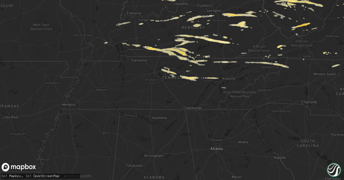
Hail Map in Tennessee on March 23, 2011
Get this storm
March 23 map
$229
one time, instant access
Download today. No call, no setup
Keep the $229
Bought the map and want the full workflow? Apply the entire $229 to a subscription within 7 days. None of it is wasted.
Every map, not just this one
This buys you this map. Subscription and you get every map we run, in the markets you choose from a few cities to whole states to nationwide. Plus real-time alerts the moment a storm fires.
Contact data
Name, contact info, occupancy, even credit band for addresses in the footprint. You go from where it hit to who to call.
Become the source they trust
Unlimited branding weather history reports on demand. You already have the documented answer ready for the property owner, and you are the one who showed up with it.
Property data and RoofTrace estimates
Pull up any address you have got, its value and the exact code rules for that jurisdiction, straight from One Click Code. Then RoofTrace estimates the squares, pitch, and roof value, priced the way you price.
Storm reports in Tennessee
Tennessee
| Date | Description |
|---|---|
| 03/23/20116:54 PM CDT | Damage began near the intersection of indian mound road and old smithville highway. Hundreds of trees were uprooted or snapped along a nearly continuous 9 mile path. Th |
| 03/23/20116:41 PM CDT | A local report indicates 1.00 inch wind near 3 W JAMESTOWN |
| 03/23/20116:40 PM CDT | Structure roof damage on dooley road |
| 03/23/20116:35 PM CDT | Trained spotter rpt quarter sized hail. |
| 03/23/20116:29 PM CDT | Quarter sized hail reported near monroe. |
| 03/23/20116:20 PM CDT | Barn blown down on old alexanria road. Ema en route to survey damage. |
| 03/23/20116:20 PM CDT | Roof blown off a home on haley road. |
| 03/23/20116:19 PM CDT | Hundreds of trees were uprooted or snapped along a nearly continuous 6 mile path. Several homes suffered significant roof damage...and a couple barns and outbuildings w |
| 03/23/20115:45 PM CDT | Trees down in the butler area reported by hwy dept and tdot. |
| 03/23/20115:42 PM CDT | Reported near west wilson school on lebanon road. |
| 03/23/20114:00 PM CDT | Quarter size hail reported by dispatch on highway 91. |
| 03/23/20113:45 PM CDT | Couple trees down. |
| 03/23/20112:32 PM CDT | Quarter size hail on highway 70n. |
| 03/23/20112:10 PM CDT | Public rpt of broken car windows |
| 03/23/20112:00 PM CDT | Public rpt of broken car windows |
| 03/23/201112:20 AM CDT | Quarter size hail reported by spotter. |
| 03/22/20118:57 PM CDT | Possible tornado reported by ham...multiple trees down and possible injuries on janeway rd. |
| 03/22/20118:55 PM CDT | *** 1 inj *** possible tornado...3 story house destroyed and roof blown off another house. |
| 03/22/20118:50 PM CDT | Ef-3 tornado with maximum winds of 140 mph and maximum path width of 500 yards with a 4.5 mile length. |
| 03/22/20118:50 PM CDT | Possible tornado reported by dispatch...mutiple power lines and trees down on hwy 95 also damage to roof of house. |
| 03/22/20118:35 PM CDT | One tree down on the spur-hwy 441 between gatlinburg and pigeon forge. Reported by dispatch. |
| 03/22/20118:35 PM CDT | One tree down on river devide rd. Reported by dispatch. |
| 03/22/20118:34 PM CDT | One tree down in del rio. Reported by dispatch. |
| 03/22/20118:20 PM CDT | One tree down on hwy 346 in surgoinsville. Reported by dispatch. |
| 03/22/20118:20 PM CDT | One tree down on ebbing flowing springs rd. Reported by dispatch. |
| 03/22/20118:10 PM CDT | One tree down at spring hill and one tree down at buffet mills. Reported by dispatch. |
| 03/22/20118:05 PM CDT | One tree down at blaine. Reported by dispatch. |
| 03/22/20118:05 PM CDT | One tree down at washburn. Reported by dispatch. |
| 03/22/20117:50 PM CDT | Trees reported down in hillsboro. |
| 03/22/20117:45 PM CDT | Tree reported down on gattistown road. Substation was also hit resulting in 781 residents briefly without power. |
| 03/22/20117:15 PM CDT | Several trees down. |
| 03/22/20117:10 PM CDT | Trees down in christiana. |
| 03/22/20117:04 PM CDT | A damage survey confirmed an ef-0 tornado with 70 to 80 mph winds touched down 2 miles west of christiana. Path was 1 mile long and 50 yards wide. Damage occurred on wa |
| 03/22/20117:03 PM CDT | Damage occurred on walnut grove road near hwy 231...some trees were uprooted and a small portion of shingles were removed from a few homes. A couple of outbuildings wer |
| 03/22/20117:01 PM CDT | Trailer destroyed. Trees and power lines down. Possible tornado. |
| 03/22/20117:01 PM CDT | Homes off foundation and trailer destroyed on will thompson road. Injuries reported. Possible tornado. |
All States Impacted by Hail Map on March 23, 2011
Cities Impacted by Hail Map on March 23, 2011
- Ghent, WV
- Flat Top, WV
- Fort Gay, WV
- Sparta, TN
- Glasgow, KY
- Greensburg, KY
- Cave City, KY
- Hardyville, KY
- Edmonton, KY
- Gradyville, KY
- Knob Lick, KY
- Horse Cave, KY
- Columbia, KY
- Center, KY
- Indianapolis, IN
- Gallagher, WV
- Hansford, WV
- New Manchester, WV
- Toronto, OH
- New Cumberland, WV
- Chillicothe, OH
- Josephine, WV
- Jumping Branch, WV
- Herndon, WV
- Nimitz, WV
- Cool Ridge, WV
- Amigo, WV
- Welch, WV
- Stephenson, WV
- Odd, WV
- Pineville, WV
- Hinton, WV
- Lebanon, IN
- Sewickley, PA
- Pittsburgh, PA
- Reidsville, NC
- Madison, NC
- Okeana, OH
- Hamilton, OH
- Cedar Grove, IN
- Brookville, IN
- Oxford, OH
- West Harrison, IN
- Portage, PA
- East Freedom, PA
- Claysburg, PA
- Orbisonia, PA
- Fort Littleton, PA
- Hustontown, PA
- New Marshfield, OH
- Athens, OH
- Blount, WV
- Tad, WV
- Charleston, WV
- Romney, WV
- Underwood, IN
- Orleans, IN
- Nabb, IN
- Campbellsburg, IN
- Scottsburg, IN
- Salem, IN
- Marysville, IN
- Paoli, IN
- Henryville, IN
- Lexington, IN
- West Baden Springs, IN
- Yoder, IN
- Columbia City, IN
- Scottsville, KY
- Milan, IN
- Osgood, IN
- Sunman, IN
- Patrick Springs, VA
- Bassett, VA
- Stuart, VA
- Morgantown, WV
- Walker, WV
- Crossville, TN
- Pleasant Hill, TN
- Tipp City, OH
- Troy, OH
- Salem, WV
- Auburn, KY
- Russellville, KY
- Leechburg, PA
- Vandergrift, PA
- Hyde Park, PA
- Homer City, PA
- Ford City, PA
- Shelocta, PA
- Indiana, PA
- Apollo, PA
- Spring Church, PA
- Avonmore, PA
- Kingsport, TN
- Grafton, WV
- Bruceton Mills, WV
- Albright, WV
- Friendsville, MD
- Millersburg, OH
- Baltic, OH
- Kempton, IN
- Frankfort, IN
- Forest, IN
- Pioneer, TN
- Seanor, PA
- Windber, PA
- Hooversville, PA
- Hollsopple, PA
- Alum Bank, PA
- New Paris, PA
- Vancleve, KY
- Jackson, KY
- Campton, KY
- Beattyville, KY
- Erbacon, WV
- Frametown, WV
- Birch River, WV
- Cowen, WV
- Duck, WV
- Dille, WV
- Coolville, OH
- Little Hocking, OH
- Washington, WV
- Yolyn, WV
- Lake, WV
- Pecks Mill, WV
- Wharton, WV
- Lyburn, WV
- Henlawson, WV
- Stollings, WV
- Logan, WV
- Chapmanville, WV
- Amherstdale, WV
- Mount Juliet, TN
- Watertown, TN
- Hickman, TN
- Brush Creek, TN
- Alexandria, TN
- Gordonsville, TN
- Lebanon, TN
- Baxter, TN
- New Vienna, OH
- Wilmington, OH
- Sabina, OH
- Frankfort, OH
- Greenfield, OH
- Leesburg, OH
- Washington Court House, OH
- Stanton, KY
- Winchester, KY
- Ezel, KY
- Jeffersonville, KY
- Wellington, KY
- Frenchburg, KY
- Clay City, KY
- Denniston, KY
- South Bloomingville, OH
- McArthur, OH
- Creola, OH
- New Plymouth, OH
- Summersville, WV
- Nettie, WV
- Canvas, WV
- Eubank, KY
- Somerset, KY
- Science Hill, KY
- Bethelridge, KY
- Summersville, KY
- London, KY
- Lily, KY
- Canmer, KY
- Liberty, KY
- Munfordville, KY
- Nancy, KY
- Elk Horn, KY
- Windsor, KY
- Magnolia, KY
- Campbellsville, KY
- Dunnville, KY
- Knifley, KY
- Ligonier, PA
- New Florence, PA
- Derry, PA
- McKees Rocks, PA
- Austin, KY
- Woodburn, KY
- Bowling Green, KY
- Tompkinsville, KY
- Lucas, KY
- Alvaton, KY
- Etoile, KY
- Mount Hermon, KY
- Franklin, KY
- Fountain Run, KY
- Lebanon, VA
- Honaker, VA
- Rosedale, VA
- Aliquippa, PA
- Owensboro, KY
- Utica, KY
- Calhoun, KY
- Ambridge, PA
- Cedar Bluff, VA
- Cleveland, VA
- Gibsonia, PA
- Belle, WV
- Dover, OH
- Parkersburg, WV
- Belpre, OH
- Park City, KY
- Gambier, OH
- Danville, OH
- Howard, OH
- East Waterford, PA
- Shoals, IN
- Harned, KY
- Crofton, KY
- Hopkinsville, KY
- Cerulean, KY
- Sugarcreek, OH
- Stone Creek, OH
- Fresno, OH
- Reynolds Station, KY
- Falls Of Rough, KY
- Cloverport, KY
- Fordsville, KY
- Williamsville, VA
- West Augusta, VA
- Deerfield, VA
- Cassville, PA
- Mapleton Depot, PA
- Calvin, PA
- Huntingdon, PA
- Hunker, PA
- Manilla, IN
- Waldron, IN
- Milroy, IN
- Sturgis, KY
- Brinkhaven, OH
- Glenmont, OH
- Circleville, OH
- Stoutsville, OH
- Harriman, TN
- Buffalo, WV
- Milton, WV
- Ona, WV
- Duff, TN
- Lebanon, OH
- Middletown, OH
- Monroe, OH
- Mason, OH
- Willisburg, KY
- Berlin, PA
- Somerset, PA
- Rockwood, PA
- Garrett, PA
- Sparta, NC
- Ennice, NC
- Franklin Furnace, OH
- Pedro, OH
- Knightstown, IN
- Morristown, IN
- Greenfield, IN
- Arlington, IN
- Carthage, IN
- New Kensington, PA
- Morrow, OH
- New Holland, OH
- Carrollton, OH
- Hammondsville, OH
- Chester, WV
- Stratton, OH
- Salineville, OH
- Mechanicstown, OH
- Irondale, OH
- Georgetown, PA
- Amsterdam, OH
- Empire, OH
- Bergholz, OH
- Plain City, OH
- Columbus, OH
- Dublin, OH
- Powell, OH
- Shelbyville, IN
- Saint Paul, IN
- Follansbee, WV
- Weirton, WV
- Colliers, WV
- Oil Springs, KY
- Means, KY
- Mount Sterling, KY
- West Liberty, KY
- Salyersville, KY
- Hico, WV
- New Alexandria, PA
- Hannastown, PA
- Crabtree, PA
- Greensburg, PA
- Manor, PA
- Grapeville, PA
- Penn, PA
- Mckeesport, PA
- Latrobe, PA
- West Mifflin, PA
- Trafford, PA
- East McKeesport, PA
- Westmoreland City, PA
- Forbes Road, PA
- Glenshaw, PA
- Duquesne, PA
- Irwin, PA
- Ardara, PA
- East Pittsburgh, PA
- Wilmerding, PA
- Monroeville, PA
- North Versailles, PA
- Harrison City, PA
- Pitcairn, PA
- Claridge, PA
- Murrysville, PA
- Homestead, PA
- Braddock, PA
- Export, PA
- Dravosburg, PA
- Jeannette, PA
- Delmont, PA
- Bovard, PA
- Loyalhanna, PA
- Luxor, PA
- Turtle Creek, PA
- Coraopolis, PA
- Monroe, TN
- Livingston, TN
- Wheelersburg, OH
- Ironton, OH
- Kitts Hill, OH
- Willow Wood, OH
- Clinton, PA
- Tipton, IN
- Sharpsville, IN
- West Portsmouth, OH
- Blue Creek, OH
- Otway, OH
- Ellwood City, PA
- New Palestine, IN
- Larimer, PA
- Langeloth, PA
- Verona, PA
- Morgan, PA
- Youngstown, PA
- McDonald, PA
- Presto, PA
- Midway, PA
- Sturgeon, PA
- Slovan, PA
- New Derry, PA
- Oakdale, PA
- Bolivar, PA
- Clarksburg, PA
- Bradenville, PA
- Glassport, PA
- Blairsville, PA
- Adamsburg, PA
- Hostetter, PA
- Steubenville, OH
- Carnegie, PA
- Cuddy, PA
- Slickville, PA
- Saltsburg, PA
- Laughlintown, PA
- Allison Park, PA
- Burgettstown, PA
- Bulger, PA
- Mingo Junction, OH
- Imperial, PA
- Joffre, PA
- Boswell, PA
- Bridgeville, PA
- Springfield, KY
- Speedwell, TN
- Mineral City, OH
- Somerdale, OH
- New Philadelphia, OH
- Davidsville, PA
- Johnstown, PA
- Elton, PA
- Salix, PA
- Petroleum, WV
- Davisville, WV
- Waverly, WV
- Marietta, OH
- Guysville, OH
- Vienna, WV
- Cutler, OH
- Vincent, OH
- Ramsey, IN
- Depauw, IN
- New Salisbury, IN
- Milltown, IN
- Tazewell, VA
- Vilas, NC
- Butler, TN
- Elizabethton, TN
- Mountain City, TN
- Zionville, NC
- Hookstown, PA
- Williams, IN
- Vallonia, IN
- Brownstown, IN
- Tunnelton, IN
- Bedford, IN
- Medora, IN
- Mitchell, IN
- Seymour, IN
- Lancaster, KY
- Danville, KY
- Greencastle, IN
- Avon, IN
- Coatesville, IN
- Rockville, IN
- Roachdale, IN
- North Salem, IN
- Danville, IN
- Russellville, IN
- Plainfield, IN
- Bainbridge, IN
- Baker, WV
- Moorefield, WV
- Kingman, IN
- Veedersburg, IN
- Covington, IN
- Waynetown, IN
- Crawfordsville, IN
- Hillsboro, IN
- Apple Creek, OH
- Bunola, PA
- Venetia, PA
- Monongahela, PA
- Finleyville, PA
- Monticello, KY
- Stearns, KY
- Thornton, WV
- Moatsville, WV
- Red Boiling Springs, TN
- Glasgow, WV
- Hernshaw, WV
- East Bank, WV
- Winifrede, WV
- Cabin Creek, WV
- Cedar Grove, WV
- London, WV
- Pratt, WV
- Comfort, WV
- Hugheston, WV
- Vine Grove, KY
- Radcliff, KY
- Thorntown, IN
- Jamestown, IN
- Nelsonville, OH
- Stewart, OH
- Midland, OH
- Londonderry, OH
- Chauncey, OH
- Blanchester, OH
- Goshen, OH
- Kingston, OH
- Pleasant Plain, OH
- Millfield, OH
- Amesville, OH
- Oregonia, OH
- Laurelville, OH
- Martinsville, OH
- Logan, OH
- Clarksville, OH
- The Plains, OH
- Lebanon, KY
- Westerville, OH
- Custer, KY
- Darlington, IN
- Moss, TN
- Whitleyville, TN
- Celina, TN
- Clairton, PA
- Buena Vista, PA
- Elizabeth, PA
- Fredericksburg, OH
- Dalton, OH
- Navarre, OH
- Brewster, OH
- Dundee, OH
- Mount Eaton, OH
- Massillon, OH
- Greensburg, IN
- Marysville, OH
- Rogersville, TN
- Sneedville, TN
- Thorn Hill, TN
- Gibbon Glade, PA
- Farmington, PA
- West Hamlin, WV
- Indore, WV
- Pond Gap, WV
- Fenwick, WV
- Belva, WV
- Clendenin, WV
- Hamlin, WV
- Swiss, WV
- Dunbar, WV
- Lizemores, WV
- Renick, WV
- Saint Albans, WV
- Sod, WV
- Elkview, WV
- Craigsville, WV
- Tornado, WV
- Dixie, WV
- South Charleston, WV
- Hurricane, WV
- Alum Creek, WV
- Richwood, WV
- Bickmore, WV
- Manchester, KY
- James Creek, PA
- East Bernstadt, KY
- Bradford, OH
- Covington, OH
- Pleasant Hill, OH
- Garfield, KY
- Irvington, KY
- La Follette, TN
- Gravel Switch, KY
- Rineyville, KY
- Elizabethtown, KY
- West Point, KY
- Noblesville, IN
- Westfield, IN
- Beech Grove, IN
- West Elizabeth, PA
- Mahaffey, PA
- Hardinsburg, KY
- Kittanning, PA
- Rossiter, PA
- Rochester Mills, PA
- Punxsutawney, PA
- Glen Campbell, PA
- Dayton, PA
- Smicksburg, PA
- Rushville, IN
- Deputy, IN
- Durham, NC
- Belington, WV
- Morgantown, KY
- Central City, PA
- Stoystown, PA
- Friedens, PA
- Wampum, PA
- New Galilee, PA
- Gamaliel, KY
- Dupont, IN
- Austin, IN
- Lynchburg, OH
- South Heights, PA
- Leetsdale, PA
- Dellroy, OH
- Baden, PA
- Wexford, PA
- Crescent, PA
- Sherrodsville, OH
- Strasburg, OH
- Rowlesburg, WV
- Tunnelton, WV
- Clarksburg, OH
- Sheridan, IN
- Lapel, IN
- Anderson, IN
- South Lebanon, OH
- Williamsport, OH
- Daleville, IN
- Yorktown, IN
- Oneida, TN
- Tazewell, TN
- Helenwood, TN
- New Tazewell, TN
- Coshocton, OH
- Killbuck, OH
- Markleysburg, PA
- Lake Lynn, PA
- West Chester, OH
- Kings Mills, OH
- Albany, OH
- Waynesville, OH
- Loveland, OH
- Metamora, IN
- Oldenburg, IN
- Rockbridge, OH
- Maineville, OH
- Trenton, OH
- Batesville, IN
- Cincinnati, OH
- Fountaintown, IN
- Harmony, PA
- Portersville, PA
- Prospect, PA
- Albany, KY
- Sunbury, OH
- Springfield, OH
- Crothersville, IN
- Delaware, OH
- Barbourville, KY
- Griffithsville, WV
- Reynoldsville, PA
- Mount Sterling, OH
- East Rochester, OH
- Minerva, OH
- Homeworth, OH
- Beloit, OH
- Salem, OH
- Mount Pleasant, PA
- Madison, PA
- Ruffs Dale, PA
- Youngwood, PA
- New Stanton, PA
- Fletcher, OH
- Piqua, OH
- Casstown, OH
- Freetown, IN
- Norman, IN
- Williamsburg, OH
- Mount Orab, OH
- Batavia, OH
- Bardstown, KY
- New Castle, PA
- Pomeroy, OH
- Shade, OH
- Aurora, WV
- Terra Alta, WV
- English, IN
- Paris Crossing, IN
- Commiskey, IN
- Irvine, KY
- River, KY
- Smithfield, PA
- Point Marion, PA
- Bobtown, PA
- Dilliner, PA
- New Geneva, PA
- Greensboro, PA
- Bristol, TN
- Bluff City, TN
- Lerona, WV
- Princeton, WV
- Bennington, IN
- Dillsboro, IN
- Rising Sun, IN
- Aurora, IN
- Bainbridge, OH
- Hillsboro, OH
- Butler, OH
- Bellville, OH
- Lucas, OH
- Perrysville, OH
- Summer Shade, KY
- Burkesville, KY
- Beaumont, KY
- Oakland, MD
- Left Hand, WV
- Wallback, WV
- Clay, WV
- Procious, WV
- Amma, WV
- Ivydale, WV
- Newton, WV
- Ashland, KY
- Glenwood, WV
- Crown City, OH
- Lesage, WV
- Ashton, WV
- Leon, WV
- Liberty, WV
- South Point, OH
- Chesapeake, OH
- Proctorville, OH
- Fraziers Bottom, WV
- Scottown, OH
- Red House, WV
- Johnson City, TN
- Worthville, KY
- Sanders, KY
- Church Hill, TN
- Greenville, IN
- Georgetown, IN
- Palmyra, IN
- Princeton, KY
- Osterburg, PA
- Walhonding, OH
- Warsaw, OH
- Ashville, OH
- Shepherdsville, KY
- Clarks Hill, IN
- Lafayette, IN
- Hanover, IN
- Urbana, OH
- Dennison, OH
- Uhrichsville, OH
- Midvale, OH
- Lowell, OH
- Lower Salem, OH
- Wellsville, OH
- Cardington, OH
- Magnolia, OH
- Loudonville, OH
- Newell, WV
- Mount Gilead, OH
- Big Prairie, OH
- Fredericktown, OH
- Glouster, OH
- Harrodsburg, KY
- Woolwine, VA
- Smithville, TN
- Ghent, KY
- Bolivar, OH
- Fall Branch, TN
- Surgoinsville, TN
- Jonesborough, TN
- Piney Flats, TN
- Milton, IN
- Connersville, IN
- Falmouth, IN
- Creekside, PA
- Todd, NC
- Trade, TN
- Watauga, TN
- Boone, NC
- Winchester, OH
- Radnor, OH
- Frostburg, MD
- Grantsville, MD
- Barton, MD
- Lonaconing, MD
- Accident, MD
- Darlington, PA
- Enon Valley, PA
- Adolphus, KY
- Sharon Grove, KY
- Lafayette, TN
- Lewisburg, KY
- Holland, KY
- Elkton, KY
- Hestand, KY
- South Vienna, OH
- Dover, KY
- Ripley, OH
- Maysville, KY
- Guilford, IN
- Cairnbrook, PA
- Jerome, PA
- Springdale, PA
- Cheswick, PA
- Mount Vernon, OH
- Oakmont, PA
- Lookout, WV
- Edmond, WV
- Home, PA
- West Union, OH
- Bristol, VA
- Hiltons, VA
- Ashford, WV
- Waterfall, PA
- Three Springs, PA
- Eddyville, KY
- Ostrander, OH
- Byrdstown, TN
- Jamestown, TN
- Pall Mall, TN
- Silver Point, TN
- Madison, IN
- Cassandra, PA
- Lilly, PA
- Canal Fulton, OH
- Loogootee, IN
- Ridgeview, WV
- Nellis, WV
- New Carlisle, OH
- Stockport, OH
- Waterford, OH
- Fleming, OH
- Elkfork, KY
- Ravenswood, WV
- Marengo, IN
- Saltville, VA
- Greenville, WV
- Lindside, WV
- Ballard, WV
- Union, WV
- Martinsville, VA
- Dana, IN
- Booneville, KY
- Negley, OH
- West Milton, OH
- Ludlow Falls, OH
- Taylorsville, KY
- Wilmore, PA
- Ebensburg, PA
- Mineral Point, PA
- Summerhill, PA
- Frazeysburg, OH
- Falls Mills, VA
- Freeman, WV
- Bramwell, WV
- Bluefield, VA
- Bluefield, WV
- Pocahontas, VA
- Prospect, OH
- Richwood, OH
- Old Hickory, TN
- Bloomfield, KY
- New Haven, KY
- Salvisa, KY
- Arcadia, IN
- Cicero, IN
- North Lewisburg, OH
- Isonville, KY
- Nicholasville, KY
- Wilmore, KY
- Harrisville, WV
- Rockwood, TN
- Saint Paris, OH
- Arcanum, OH
- Conover, OH
- Staffordsville, KY
- Flatgap, KY
- Martha, KY
- Keaton, KY
- Sandy Hook, KY
- Todd, PA
- Martinsburg, PA
- Saxton, PA
- Windfall, IN
- Elwood, IN
- Tollesboro, KY
- Vanceburg, KY
- Flemingsburg, KY
- Greenback, TN
- Maryville, TN
- Advance, IN
- Belleville, WV
- Rockport, WV
- Russell Springs, KY
- Paducah, KY
- Dunlow, WV
- Genoa, WV
- Gate City, VA
- Beaver, WV
- Rutland, OH
- South Shore, KY
- Woodstock, OH
- Acme, PA
- Oakdale, TN
- Carrollton, KY
- Herminie, PA
- Lowber, PA
- West Newton, PA
- Sutersville, PA
- Alpine, TN
- Allons, TN
- Abingdon, VA
- Saint Catharine, KY
- Shinnston, WV
- Bridgeport, WV
- Johnstown, OH
- Lisbon, OH
- Hanoverton, OH
- Leetonia, OH
- Beaver, OH
- Larwill, IN
- Bradfordsville, KY
- Perryville, KY
- Stout, OH
- Lebanon Junction, KY
- Slab Fork, WV
- Lester, WV
- Hopedale, OH
- Jewett, OH
- Cookeville, TN
- Racine, WV
- Sumerco, WV
- Yawkey, WV
- Costa, WV
- Cecilia, KY
- Reedsville, WV
- Independence, WV
- Kingwood, WV
- Newburg, WV
- Mount Nebo, WV
- Nallen, WV
- Quinwood, WV
- Charmco, WV
- Waverly, OH
- Hollidaysburg, PA
- Darragh, PA
- Hambleton, WV
- Davis, WV
- Beaver Falls, PA
- Galena, OH
- Harlan, KY
- Cawood, KY
- Pathfork, KY
- Lewis Center, OH
- Bedford, KY
- French Lick, IN
- Milton, KY
- Pekin, IN
- Burlington, WV
- Purgitsville, WV
- Waverly, KY
- Corydon, KY
- Morganfield, KY
- Alkol, WV
- Eskdale, WV
- Drybranch, WV
- Lexington, VA
- Farmland, IN
- Modoc, IN
- Lancaster, OH
- Tarlton, OH
- Amanda, OH
- Sugar Grove, OH
- Culloden, WV
- Hilham, TN
- Rockfield, KY
- Newcomerstown, OH
- Port Washington, OH
- Selma, IN
- Auburntown, TN
- Liberty, TN
- Oak Ridge, TN
- Crab Orchard, TN
- Oliver Springs, TN
- Clarksburg, WV
- Confluence, PA
- Fort Hill, PA
- Markleton, PA
- Wellston, OH
- Hamden, OH
- Eglon, WV
- Mount Vernon, KY
- Brodhead, KY
- Claypool, IN
- East Palestine, OH
- Warm Springs, VA
- Swoope, VA
- Cannelburg, IN
- New Enterprise, PA
- Peytona, WV
- Foster, WV
- Coxs Creek, KY
- Stokesdale, NC
- Sutton, WV
- Woodbury, PA
- Broad Top, PA
- Rillton, PA
- Fishertown, PA
- Bowerston, OH
- Greenock, PA
- Gnadenhutten, OH
- Imler, PA
- Scio, OH
- Bethel Park, PA
- Tuscarawas, OH
- Beach City, OH
- Schellsburg, PA
- Roaring Spring, PA
- Edison, OH
- Sidman, PA
- Dudley, PA
- Mooresburg, TN
- Junction, IL
- Elizabethtown, IL
- Cave In Rock, IL
- Louisa, KY
- Clayhole, KY
- Granville, WV
- Campbellsburg, KY
- Turners Station, KY
- Owenton, KY
- Walton, WV
- Mill Run, PA
- Washington, IN
- Brownsburg, IN
- Manchester, OH
- Milford, OH
- Garrison, KY
- Duncansville, PA
- Parker City, IN
- Winchester, IN
- Fieldale, VA
- New Creek, WV
- Versailles, KY
- Fredericksburg, IN
- Lucasville, OH
- McDermott, OH
- Portsmouth, OH
- Dingess, WV
- Harts, WV
- New Ross, IN
- Yosemite, KY
- Waynesburg, KY
- Hawesville, KY
- Philpot, KY
- Whitesville, KY
- Victor, WV
- Ansted, WV
- Russellton, PA
- Tarentum, PA
- Peebles, OH
- Kuttawa, KY
- Perrysville, IN
- Rogers, OH
- Clifton Forge, VA
- Centerburg, OH
- New Eagle, PA
- Cross Plains, IN
- Versailles, IN
- Lumberport, WV
- Six Mile Run, PA
- Blanch, NC
- Yanceyville, NC
- Cairo, WV
- Saint Marys, WV
- Ellenboro, WV
- Armagh, PA
- Wittensville, KY
- Sitka, KY
- Sadieville, KY


