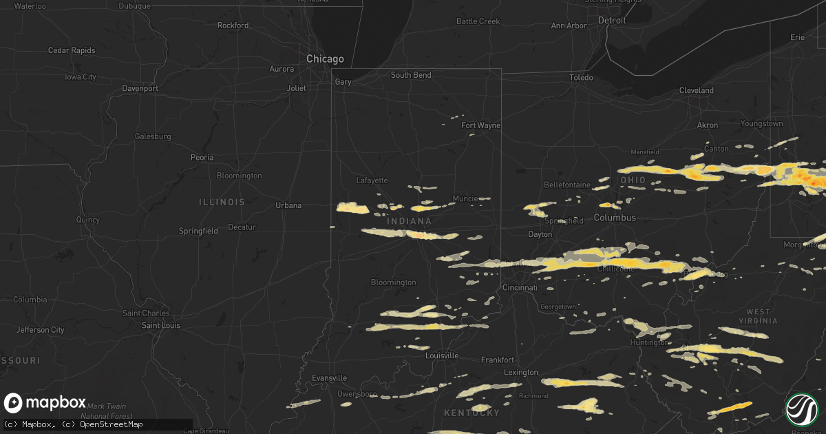
Hail Map in Indiana on March 23, 2011
Get this storm
March 23 map
$229
one time, instant access
Download today. No call, no setup
Keep the $229
Bought the map and want the full workflow? Apply the entire $229 to a subscription within 7 days. None of it is wasted.
Every map, not just this one
This buys you this map. Subscription and you get every map we run, in the markets you choose from a few cities to whole states to nationwide. Plus real-time alerts the moment a storm fires.
Contact data
Name, contact info, occupancy, even credit band for addresses in the footprint. You go from where it hit to who to call.
Become the source they trust
Unlimited branding weather history reports on demand. You already have the documented answer ready for the property owner, and you are the one who showed up with it.
Property data and RoofTrace estimates
Pull up any address you have got, its value and the exact code rules for that jurisdiction, straight from One Click Code. Then RoofTrace estimates the squares, pitch, and roof value, priced the way you price.
Storm reports in Indiana
Indiana
| Date | Description |
|---|---|
| 03/23/20116:53 PM CDT | Quarter sized hail at hwy 32 and spring mill rd. |
| 03/23/20116:47 PM CDT | East side of lebanon. |
| 03/23/20116:40 PM CDT | Reported in northwest lebanon. |
| 03/23/20116:33 PM CDT | Emergency manager reports dime to quarter sized hail at 1000 e and 400 s. |
| 03/23/20116:32 PM CDT | Near 600 w and 200 n. |
| 03/23/20116:25 PM CDT | 1.25 inch hail...wall cloud also observed. |
| 03/23/20116:24 PM CDT | A local report indicates 1.00 inch wind near THORNTOWN |
| 03/23/20116:07 PM CDT | A local report indicates 1.75 inch wind near WAYNETOWN |
| 03/23/20116:01 PM CDT | A local report indicates 1.75 inch wind near VEEDERSBURG |
| 03/23/20115:55 PM CDT | A local report indicates 1.75 inch wind near COVINGTON |
| 03/23/20115:44 PM CDT | Emergency manager reports hail ranging from pea sized to golf ball size. |
| 03/23/20115:38 PM CDT | A local report indicates 1.00 inch wind near CICERO |
| 03/23/20112:35 PM CDT | Pea size hail also reported. |
| 03/23/20112:13 PM CDT | A local report indicates 1.00 inch wind near MADISON |
| 03/23/20111:52 PM CDT | Hail was covering the ground... Vehicles dented |
| 03/23/20111:27 PM CDT | A local report indicates 1.00 inch wind near LIBERTY |
| 03/23/20111:22 PM CDT | A tree was blown down on 175 w southwest of paoli. |
| 03/23/20111:19 PM CDT | Officers reported hail from dime to quarter size. |
| 03/23/20111:00 PM CDT | Near 450 e and 450 s. 30 homes damaged by hail...including roof...siding and window damage. |
| 03/23/201112:48 PM CDT | A local report indicates 1.00 inch wind near WILLIAMS |
| 03/22/20119:00 PM CDT | Numerous power outages between whiteland and greenwood. |
| 03/22/20118:41 PM CDT | A local report indicates 1.00 inch wind near OSGOOD |
| 03/22/20118:18 PM CDT | Numerous reports of pea to quarter sized hail. |
| 03/22/20118:10 PM CDT | At sr 140 and rushville rd. |
| 03/22/20117:42 PM CDT | Reported 1 s of highway 32. |
| 03/22/20117:36 PM CDT | A local report indicates 1.00 inch wind near NEW PALESTINE |
| 03/22/20117:30 PM CDT | Near 4th and buffalo ave in beech grove. |
| 03/22/20117:30 PM CDT | East indianapolis...near raymond and franklin. |
| 03/22/20117:20 PM CDT | A local report indicates 1.25 inch wind near 1 S INDIANAPOLIS |
| 03/22/20117:13 PM CDT | A local report indicates 1.00 inch wind near 7 SW INDIANAPOLIS |
| 03/22/20117:07 PM CDT | A local report indicates 1.00 inch wind near AVON |
| 03/22/20117:03 PM CDT | A local report indicates 1.00 inch wind near AVON |
| 03/22/20117:00 PM CDT | Eastern noblesville near the intersection of 32 and 37. |
| 03/22/20117:00 PM CDT | Garage blown in. |
All States Impacted by Hail Map on March 23, 2011
Cities Impacted by Hail Map on March 23, 2011
- Ghent, WV
- Flat Top, WV
- Fort Gay, WV
- Sparta, TN
- Glasgow, KY
- Greensburg, KY
- Cave City, KY
- Hardyville, KY
- Edmonton, KY
- Gradyville, KY
- Knob Lick, KY
- Horse Cave, KY
- Columbia, KY
- Center, KY
- Indianapolis, IN
- Gallagher, WV
- Hansford, WV
- New Manchester, WV
- Toronto, OH
- New Cumberland, WV
- Chillicothe, OH
- Josephine, WV
- Jumping Branch, WV
- Herndon, WV
- Nimitz, WV
- Cool Ridge, WV
- Amigo, WV
- Welch, WV
- Stephenson, WV
- Odd, WV
- Pineville, WV
- Hinton, WV
- Lebanon, IN
- Sewickley, PA
- Pittsburgh, PA
- Reidsville, NC
- Madison, NC
- Okeana, OH
- Hamilton, OH
- Cedar Grove, IN
- Brookville, IN
- Oxford, OH
- West Harrison, IN
- Portage, PA
- East Freedom, PA
- Claysburg, PA
- Orbisonia, PA
- Fort Littleton, PA
- Hustontown, PA
- New Marshfield, OH
- Athens, OH
- Blount, WV
- Tad, WV
- Charleston, WV
- Romney, WV
- Underwood, IN
- Orleans, IN
- Nabb, IN
- Campbellsburg, IN
- Scottsburg, IN
- Salem, IN
- Marysville, IN
- Paoli, IN
- Henryville, IN
- Lexington, IN
- West Baden Springs, IN
- Yoder, IN
- Columbia City, IN
- Scottsville, KY
- Milan, IN
- Osgood, IN
- Sunman, IN
- Patrick Springs, VA
- Bassett, VA
- Stuart, VA
- Morgantown, WV
- Walker, WV
- Crossville, TN
- Pleasant Hill, TN
- Tipp City, OH
- Troy, OH
- Salem, WV
- Auburn, KY
- Russellville, KY
- Leechburg, PA
- Vandergrift, PA
- Hyde Park, PA
- Homer City, PA
- Ford City, PA
- Shelocta, PA
- Indiana, PA
- Apollo, PA
- Spring Church, PA
- Avonmore, PA
- Kingsport, TN
- Grafton, WV
- Bruceton Mills, WV
- Albright, WV
- Friendsville, MD
- Millersburg, OH
- Baltic, OH
- Kempton, IN
- Frankfort, IN
- Forest, IN
- Pioneer, TN
- Seanor, PA
- Windber, PA
- Hooversville, PA
- Hollsopple, PA
- Alum Bank, PA
- New Paris, PA
- Vancleve, KY
- Jackson, KY
- Campton, KY
- Beattyville, KY
- Erbacon, WV
- Frametown, WV
- Birch River, WV
- Cowen, WV
- Duck, WV
- Dille, WV
- Coolville, OH
- Little Hocking, OH
- Washington, WV
- Yolyn, WV
- Lake, WV
- Pecks Mill, WV
- Wharton, WV
- Lyburn, WV
- Henlawson, WV
- Stollings, WV
- Logan, WV
- Chapmanville, WV
- Amherstdale, WV
- Mount Juliet, TN
- Watertown, TN
- Hickman, TN
- Brush Creek, TN
- Alexandria, TN
- Gordonsville, TN
- Lebanon, TN
- Baxter, TN
- New Vienna, OH
- Wilmington, OH
- Sabina, OH
- Frankfort, OH
- Greenfield, OH
- Leesburg, OH
- Washington Court House, OH
- Stanton, KY
- Winchester, KY
- Ezel, KY
- Jeffersonville, KY
- Wellington, KY
- Frenchburg, KY
- Clay City, KY
- Denniston, KY
- South Bloomingville, OH
- McArthur, OH
- Creola, OH
- New Plymouth, OH
- Summersville, WV
- Nettie, WV
- Canvas, WV
- Eubank, KY
- Somerset, KY
- Science Hill, KY
- Bethelridge, KY
- Summersville, KY
- London, KY
- Lily, KY
- Canmer, KY
- Liberty, KY
- Munfordville, KY
- Nancy, KY
- Elk Horn, KY
- Windsor, KY
- Magnolia, KY
- Campbellsville, KY
- Dunnville, KY
- Knifley, KY
- Ligonier, PA
- New Florence, PA
- Derry, PA
- McKees Rocks, PA
- Austin, KY
- Woodburn, KY
- Bowling Green, KY
- Tompkinsville, KY
- Lucas, KY
- Alvaton, KY
- Etoile, KY
- Mount Hermon, KY
- Franklin, KY
- Fountain Run, KY
- Lebanon, VA
- Honaker, VA
- Rosedale, VA
- Aliquippa, PA
- Owensboro, KY
- Utica, KY
- Calhoun, KY
- Ambridge, PA
- Cedar Bluff, VA
- Cleveland, VA
- Gibsonia, PA
- Belle, WV
- Dover, OH
- Parkersburg, WV
- Belpre, OH
- Park City, KY
- Gambier, OH
- Danville, OH
- Howard, OH
- East Waterford, PA
- Shoals, IN
- Harned, KY
- Crofton, KY
- Hopkinsville, KY
- Cerulean, KY
- Sugarcreek, OH
- Stone Creek, OH
- Fresno, OH
- Reynolds Station, KY
- Falls Of Rough, KY
- Cloverport, KY
- Fordsville, KY
- Williamsville, VA
- West Augusta, VA
- Deerfield, VA
- Cassville, PA
- Mapleton Depot, PA
- Calvin, PA
- Huntingdon, PA
- Hunker, PA
- Manilla, IN
- Waldron, IN
- Milroy, IN
- Sturgis, KY
- Brinkhaven, OH
- Glenmont, OH
- Circleville, OH
- Stoutsville, OH
- Harriman, TN
- Buffalo, WV
- Milton, WV
- Ona, WV
- Duff, TN
- Lebanon, OH
- Middletown, OH
- Monroe, OH
- Mason, OH
- Willisburg, KY
- Berlin, PA
- Somerset, PA
- Rockwood, PA
- Garrett, PA
- Sparta, NC
- Ennice, NC
- Franklin Furnace, OH
- Pedro, OH
- Knightstown, IN
- Morristown, IN
- Greenfield, IN
- Arlington, IN
- Carthage, IN
- New Kensington, PA
- Morrow, OH
- New Holland, OH
- Carrollton, OH
- Hammondsville, OH
- Chester, WV
- Stratton, OH
- Salineville, OH
- Mechanicstown, OH
- Irondale, OH
- Georgetown, PA
- Amsterdam, OH
- Empire, OH
- Bergholz, OH
- Plain City, OH
- Columbus, OH
- Dublin, OH
- Powell, OH
- Shelbyville, IN
- Saint Paul, IN
- Follansbee, WV
- Weirton, WV
- Colliers, WV
- Oil Springs, KY
- Means, KY
- Mount Sterling, KY
- West Liberty, KY
- Salyersville, KY
- Hico, WV
- New Alexandria, PA
- Hannastown, PA
- Crabtree, PA
- Greensburg, PA
- Manor, PA
- Grapeville, PA
- Penn, PA
- Mckeesport, PA
- Latrobe, PA
- West Mifflin, PA
- Trafford, PA
- East McKeesport, PA
- Westmoreland City, PA
- Forbes Road, PA
- Glenshaw, PA
- Duquesne, PA
- Irwin, PA
- Ardara, PA
- East Pittsburgh, PA
- Wilmerding, PA
- Monroeville, PA
- North Versailles, PA
- Harrison City, PA
- Pitcairn, PA
- Claridge, PA
- Murrysville, PA
- Homestead, PA
- Braddock, PA
- Export, PA
- Dravosburg, PA
- Jeannette, PA
- Delmont, PA
- Bovard, PA
- Loyalhanna, PA
- Luxor, PA
- Turtle Creek, PA
- Coraopolis, PA
- Monroe, TN
- Livingston, TN
- Wheelersburg, OH
- Ironton, OH
- Kitts Hill, OH
- Willow Wood, OH
- Clinton, PA
- Tipton, IN
- Sharpsville, IN
- West Portsmouth, OH
- Blue Creek, OH
- Otway, OH
- Ellwood City, PA
- New Palestine, IN
- Larimer, PA
- Langeloth, PA
- Verona, PA
- Morgan, PA
- Youngstown, PA
- McDonald, PA
- Presto, PA
- Midway, PA
- Sturgeon, PA
- Slovan, PA
- New Derry, PA
- Oakdale, PA
- Bolivar, PA
- Clarksburg, PA
- Bradenville, PA
- Glassport, PA
- Blairsville, PA
- Adamsburg, PA
- Hostetter, PA
- Steubenville, OH
- Carnegie, PA
- Cuddy, PA
- Slickville, PA
- Saltsburg, PA
- Laughlintown, PA
- Allison Park, PA
- Burgettstown, PA
- Bulger, PA
- Mingo Junction, OH
- Imperial, PA
- Joffre, PA
- Boswell, PA
- Bridgeville, PA
- Springfield, KY
- Speedwell, TN
- Mineral City, OH
- Somerdale, OH
- New Philadelphia, OH
- Davidsville, PA
- Johnstown, PA
- Elton, PA
- Salix, PA
- Petroleum, WV
- Davisville, WV
- Waverly, WV
- Marietta, OH
- Guysville, OH
- Vienna, WV
- Cutler, OH
- Vincent, OH
- Ramsey, IN
- Depauw, IN
- New Salisbury, IN
- Milltown, IN
- Tazewell, VA
- Vilas, NC
- Butler, TN
- Elizabethton, TN
- Mountain City, TN
- Zionville, NC
- Hookstown, PA
- Williams, IN
- Vallonia, IN
- Brownstown, IN
- Tunnelton, IN
- Bedford, IN
- Medora, IN
- Mitchell, IN
- Seymour, IN
- Lancaster, KY
- Danville, KY
- Greencastle, IN
- Avon, IN
- Coatesville, IN
- Rockville, IN
- Roachdale, IN
- North Salem, IN
- Danville, IN
- Russellville, IN
- Plainfield, IN
- Bainbridge, IN
- Baker, WV
- Moorefield, WV
- Kingman, IN
- Veedersburg, IN
- Covington, IN
- Waynetown, IN
- Crawfordsville, IN
- Hillsboro, IN
- Apple Creek, OH
- Bunola, PA
- Venetia, PA
- Monongahela, PA
- Finleyville, PA
- Monticello, KY
- Stearns, KY
- Thornton, WV
- Moatsville, WV
- Red Boiling Springs, TN
- Glasgow, WV
- Hernshaw, WV
- East Bank, WV
- Winifrede, WV
- Cabin Creek, WV
- Cedar Grove, WV
- London, WV
- Pratt, WV
- Comfort, WV
- Hugheston, WV
- Vine Grove, KY
- Radcliff, KY
- Thorntown, IN
- Jamestown, IN
- Nelsonville, OH
- Stewart, OH
- Midland, OH
- Londonderry, OH
- Chauncey, OH
- Blanchester, OH
- Goshen, OH
- Kingston, OH
- Pleasant Plain, OH
- Millfield, OH
- Amesville, OH
- Oregonia, OH
- Laurelville, OH
- Martinsville, OH
- Logan, OH
- Clarksville, OH
- The Plains, OH
- Lebanon, KY
- Westerville, OH
- Custer, KY
- Darlington, IN
- Moss, TN
- Whitleyville, TN
- Celina, TN
- Clairton, PA
- Buena Vista, PA
- Elizabeth, PA
- Fredericksburg, OH
- Dalton, OH
- Navarre, OH
- Brewster, OH
- Dundee, OH
- Mount Eaton, OH
- Massillon, OH
- Greensburg, IN
- Marysville, OH
- Rogersville, TN
- Sneedville, TN
- Thorn Hill, TN
- Gibbon Glade, PA
- Farmington, PA
- West Hamlin, WV
- Indore, WV
- Pond Gap, WV
- Fenwick, WV
- Belva, WV
- Clendenin, WV
- Hamlin, WV
- Swiss, WV
- Dunbar, WV
- Lizemores, WV
- Renick, WV
- Saint Albans, WV
- Sod, WV
- Elkview, WV
- Craigsville, WV
- Tornado, WV
- Dixie, WV
- South Charleston, WV
- Hurricane, WV
- Alum Creek, WV
- Richwood, WV
- Bickmore, WV
- Manchester, KY
- James Creek, PA
- East Bernstadt, KY
- Bradford, OH
- Covington, OH
- Pleasant Hill, OH
- Garfield, KY
- Irvington, KY
- La Follette, TN
- Gravel Switch, KY
- Rineyville, KY
- Elizabethtown, KY
- West Point, KY
- Noblesville, IN
- Westfield, IN
- Beech Grove, IN
- West Elizabeth, PA
- Mahaffey, PA
- Hardinsburg, KY
- Kittanning, PA
- Rossiter, PA
- Rochester Mills, PA
- Punxsutawney, PA
- Glen Campbell, PA
- Dayton, PA
- Smicksburg, PA
- Rushville, IN
- Deputy, IN
- Durham, NC
- Belington, WV
- Morgantown, KY
- Central City, PA
- Stoystown, PA
- Friedens, PA
- Wampum, PA
- New Galilee, PA
- Gamaliel, KY
- Dupont, IN
- Austin, IN
- Lynchburg, OH
- South Heights, PA
- Leetsdale, PA
- Dellroy, OH
- Baden, PA
- Wexford, PA
- Crescent, PA
- Sherrodsville, OH
- Strasburg, OH
- Rowlesburg, WV
- Tunnelton, WV
- Clarksburg, OH
- Sheridan, IN
- Lapel, IN
- Anderson, IN
- South Lebanon, OH
- Williamsport, OH
- Daleville, IN
- Yorktown, IN
- Oneida, TN
- Tazewell, TN
- Helenwood, TN
- New Tazewell, TN
- Coshocton, OH
- Killbuck, OH
- Markleysburg, PA
- Lake Lynn, PA
- West Chester, OH
- Kings Mills, OH
- Albany, OH
- Waynesville, OH
- Loveland, OH
- Metamora, IN
- Oldenburg, IN
- Rockbridge, OH
- Maineville, OH
- Trenton, OH
- Batesville, IN
- Cincinnati, OH
- Fountaintown, IN
- Harmony, PA
- Portersville, PA
- Prospect, PA
- Albany, KY
- Sunbury, OH
- Springfield, OH
- Crothersville, IN
- Delaware, OH
- Barbourville, KY
- Griffithsville, WV
- Reynoldsville, PA
- Mount Sterling, OH
- East Rochester, OH
- Minerva, OH
- Homeworth, OH
- Beloit, OH
- Salem, OH
- Mount Pleasant, PA
- Madison, PA
- Ruffs Dale, PA
- Youngwood, PA
- New Stanton, PA
- Fletcher, OH
- Piqua, OH
- Casstown, OH
- Freetown, IN
- Norman, IN
- Williamsburg, OH
- Mount Orab, OH
- Batavia, OH
- Bardstown, KY
- New Castle, PA
- Pomeroy, OH
- Shade, OH
- Aurora, WV
- Terra Alta, WV
- English, IN
- Paris Crossing, IN
- Commiskey, IN
- Irvine, KY
- River, KY
- Smithfield, PA
- Point Marion, PA
- Bobtown, PA
- Dilliner, PA
- New Geneva, PA
- Greensboro, PA
- Bristol, TN
- Bluff City, TN
- Lerona, WV
- Princeton, WV
- Bennington, IN
- Dillsboro, IN
- Rising Sun, IN
- Aurora, IN
- Bainbridge, OH
- Hillsboro, OH
- Butler, OH
- Bellville, OH
- Lucas, OH
- Perrysville, OH
- Summer Shade, KY
- Burkesville, KY
- Beaumont, KY
- Oakland, MD
- Left Hand, WV
- Wallback, WV
- Clay, WV
- Procious, WV
- Amma, WV
- Ivydale, WV
- Newton, WV
- Ashland, KY
- Glenwood, WV
- Crown City, OH
- Lesage, WV
- Ashton, WV
- Leon, WV
- Liberty, WV
- South Point, OH
- Chesapeake, OH
- Proctorville, OH
- Fraziers Bottom, WV
- Scottown, OH
- Red House, WV
- Johnson City, TN
- Worthville, KY
- Sanders, KY
- Church Hill, TN
- Greenville, IN
- Georgetown, IN
- Palmyra, IN
- Princeton, KY
- Osterburg, PA
- Walhonding, OH
- Warsaw, OH
- Ashville, OH
- Shepherdsville, KY
- Clarks Hill, IN
- Lafayette, IN
- Hanover, IN
- Urbana, OH
- Dennison, OH
- Uhrichsville, OH
- Midvale, OH
- Lowell, OH
- Lower Salem, OH
- Wellsville, OH
- Cardington, OH
- Magnolia, OH
- Loudonville, OH
- Newell, WV
- Mount Gilead, OH
- Big Prairie, OH
- Fredericktown, OH
- Glouster, OH
- Harrodsburg, KY
- Woolwine, VA
- Smithville, TN
- Ghent, KY
- Bolivar, OH
- Fall Branch, TN
- Surgoinsville, TN
- Jonesborough, TN
- Piney Flats, TN
- Milton, IN
- Connersville, IN
- Falmouth, IN
- Creekside, PA
- Todd, NC
- Trade, TN
- Watauga, TN
- Boone, NC
- Winchester, OH
- Radnor, OH
- Frostburg, MD
- Grantsville, MD
- Barton, MD
- Lonaconing, MD
- Accident, MD
- Darlington, PA
- Enon Valley, PA
- Adolphus, KY
- Sharon Grove, KY
- Lafayette, TN
- Lewisburg, KY
- Holland, KY
- Elkton, KY
- Hestand, KY
- South Vienna, OH
- Dover, KY
- Ripley, OH
- Maysville, KY
- Guilford, IN
- Cairnbrook, PA
- Jerome, PA
- Springdale, PA
- Cheswick, PA
- Mount Vernon, OH
- Oakmont, PA
- Lookout, WV
- Edmond, WV
- Home, PA
- West Union, OH
- Bristol, VA
- Hiltons, VA
- Ashford, WV
- Waterfall, PA
- Three Springs, PA
- Eddyville, KY
- Ostrander, OH
- Byrdstown, TN
- Jamestown, TN
- Pall Mall, TN
- Silver Point, TN
- Madison, IN
- Cassandra, PA
- Lilly, PA
- Canal Fulton, OH
- Loogootee, IN
- Ridgeview, WV
- Nellis, WV
- New Carlisle, OH
- Stockport, OH
- Waterford, OH
- Fleming, OH
- Elkfork, KY
- Ravenswood, WV
- Marengo, IN
- Saltville, VA
- Greenville, WV
- Lindside, WV
- Ballard, WV
- Union, WV
- Martinsville, VA
- Dana, IN
- Booneville, KY
- Negley, OH
- West Milton, OH
- Ludlow Falls, OH
- Taylorsville, KY
- Wilmore, PA
- Ebensburg, PA
- Mineral Point, PA
- Summerhill, PA
- Frazeysburg, OH
- Falls Mills, VA
- Freeman, WV
- Bramwell, WV
- Bluefield, VA
- Bluefield, WV
- Pocahontas, VA
- Prospect, OH
- Richwood, OH
- Old Hickory, TN
- Bloomfield, KY
- New Haven, KY
- Salvisa, KY
- Arcadia, IN
- Cicero, IN
- North Lewisburg, OH
- Isonville, KY
- Nicholasville, KY
- Wilmore, KY
- Harrisville, WV
- Rockwood, TN
- Saint Paris, OH
- Arcanum, OH
- Conover, OH
- Staffordsville, KY
- Flatgap, KY
- Martha, KY
- Keaton, KY
- Sandy Hook, KY
- Todd, PA
- Martinsburg, PA
- Saxton, PA
- Windfall, IN
- Elwood, IN
- Tollesboro, KY
- Vanceburg, KY
- Flemingsburg, KY
- Greenback, TN
- Maryville, TN
- Advance, IN
- Belleville, WV
- Rockport, WV
- Russell Springs, KY
- Paducah, KY
- Dunlow, WV
- Genoa, WV
- Gate City, VA
- Beaver, WV
- Rutland, OH
- South Shore, KY
- Woodstock, OH
- Acme, PA
- Oakdale, TN
- Carrollton, KY
- Herminie, PA
- Lowber, PA
- West Newton, PA
- Sutersville, PA
- Alpine, TN
- Allons, TN
- Abingdon, VA
- Saint Catharine, KY
- Shinnston, WV
- Bridgeport, WV
- Johnstown, OH
- Lisbon, OH
- Hanoverton, OH
- Leetonia, OH
- Beaver, OH
- Larwill, IN
- Bradfordsville, KY
- Perryville, KY
- Stout, OH
- Lebanon Junction, KY
- Slab Fork, WV
- Lester, WV
- Hopedale, OH
- Jewett, OH
- Cookeville, TN
- Racine, WV
- Sumerco, WV
- Yawkey, WV
- Costa, WV
- Cecilia, KY
- Reedsville, WV
- Independence, WV
- Kingwood, WV
- Newburg, WV
- Mount Nebo, WV
- Nallen, WV
- Quinwood, WV
- Charmco, WV
- Waverly, OH
- Hollidaysburg, PA
- Darragh, PA
- Hambleton, WV
- Davis, WV
- Beaver Falls, PA
- Galena, OH
- Harlan, KY
- Cawood, KY
- Pathfork, KY
- Lewis Center, OH
- Bedford, KY
- French Lick, IN
- Milton, KY
- Pekin, IN
- Burlington, WV
- Purgitsville, WV
- Waverly, KY
- Corydon, KY
- Morganfield, KY
- Alkol, WV
- Eskdale, WV
- Drybranch, WV
- Lexington, VA
- Farmland, IN
- Modoc, IN
- Lancaster, OH
- Tarlton, OH
- Amanda, OH
- Sugar Grove, OH
- Culloden, WV
- Hilham, TN
- Rockfield, KY
- Newcomerstown, OH
- Port Washington, OH
- Selma, IN
- Auburntown, TN
- Liberty, TN
- Oak Ridge, TN
- Crab Orchard, TN
- Oliver Springs, TN
- Clarksburg, WV
- Confluence, PA
- Fort Hill, PA
- Markleton, PA
- Wellston, OH
- Hamden, OH
- Eglon, WV
- Mount Vernon, KY
- Brodhead, KY
- Claypool, IN
- East Palestine, OH
- Warm Springs, VA
- Swoope, VA
- Cannelburg, IN
- New Enterprise, PA
- Peytona, WV
- Foster, WV
- Coxs Creek, KY
- Stokesdale, NC
- Sutton, WV
- Woodbury, PA
- Broad Top, PA
- Rillton, PA
- Fishertown, PA
- Bowerston, OH
- Greenock, PA
- Gnadenhutten, OH
- Imler, PA
- Scio, OH
- Bethel Park, PA
- Tuscarawas, OH
- Beach City, OH
- Schellsburg, PA
- Roaring Spring, PA
- Edison, OH
- Sidman, PA
- Dudley, PA
- Mooresburg, TN
- Junction, IL
- Elizabethtown, IL
- Cave In Rock, IL
- Louisa, KY
- Clayhole, KY
- Granville, WV
- Campbellsburg, KY
- Turners Station, KY
- Owenton, KY
- Walton, WV
- Mill Run, PA
- Washington, IN
- Brownsburg, IN
- Manchester, OH
- Milford, OH
- Garrison, KY
- Duncansville, PA
- Parker City, IN
- Winchester, IN
- Fieldale, VA
- New Creek, WV
- Versailles, KY
- Fredericksburg, IN
- Lucasville, OH
- McDermott, OH
- Portsmouth, OH
- Dingess, WV
- Harts, WV
- New Ross, IN
- Yosemite, KY
- Waynesburg, KY
- Hawesville, KY
- Philpot, KY
- Whitesville, KY
- Victor, WV
- Ansted, WV
- Russellton, PA
- Tarentum, PA
- Peebles, OH
- Kuttawa, KY
- Perrysville, IN
- Rogers, OH
- Clifton Forge, VA
- Centerburg, OH
- New Eagle, PA
- Cross Plains, IN
- Versailles, IN
- Lumberport, WV
- Six Mile Run, PA
- Blanch, NC
- Yanceyville, NC
- Cairo, WV
- Saint Marys, WV
- Ellenboro, WV
- Armagh, PA
- Wittensville, KY
- Sitka, KY
- Sadieville, KY


