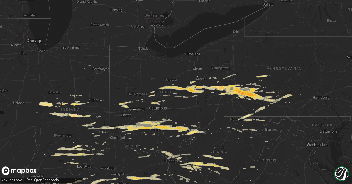
Hail Map in Ohio on March 23, 2011
Get this storm
March 23 map
$229
one time, instant access
Download today. No call, no setup
Keep the $229
Bought the map and want the full workflow? Apply the entire $229 to a subscription within 7 days. None of it is wasted.
Every map, not just this one
This buys you this map. Subscription and you get every map we run, in the markets you choose from a few cities to whole states to nationwide. Plus real-time alerts the moment a storm fires.
Contact data
Name, contact info, occupancy, even credit band for addresses in the footprint. You go from where it hit to who to call.
Become the source they trust
Unlimited branding weather history reports on demand. You already have the documented answer ready for the property owner, and you are the one who showed up with it.
Property data and RoofTrace estimates
Pull up any address you have got, its value and the exact code rules for that jurisdiction, straight from One Click Code. Then RoofTrace estimates the squares, pitch, and roof value, priced the way you price.
Storm reports in Ohio
Ohio
| Date | Description |
|---|---|
| 03/23/20114:27 PM CDT | 55mph gust reported...sheeting falling off houses...branches off trees...and several trees falling down |
| 03/23/20114:15 PM CDT | Town of willow wood |
| 03/23/20114:00 PM CDT | Barn lifted off of ground with concrete...outbuilding picked up and blown across street...roof blown off home...numerous trees and power lines down |
| 03/23/20113:55 PM CDT | A local report indicates 1.00 inch wind near 2 SSW LITTLE HOCKING |
| 03/23/20113:42 PM CDT | Numerous trees down and power outages. |
| 03/23/20113:42 PM CDT | *** 1 fatal *** corrected report. A woman in her 20s was killed by a falling tree while she was camping at the shawnee state forest. Earlier reports of a child killed a |
| 03/23/20113:40 PM CDT | Several trees reported down around athens township |
| 03/23/20113:38 PM CDT | *** 1 fatal *** a tree fell on a child who was inside a tent at a boy scout camp in the shawnee state forest. Fatality time is estimated. Corrected time from previous r |
| 03/23/20113:35 PM CDT | Power lines down on big run road just east of sr 23. |
| 03/23/20113:34 PM CDT | Trees and power lines down |
| 03/23/20113:34 PM CDT | House trailer being towed blown over |
| 03/23/20113:33 PM CDT | A local report indicates 1.00 inch wind near SALINEVILLE |
| 03/23/20113:30 PM CDT | A local report indicates 1.25 inch wind near IRONDALE |
| 03/23/20113:28 PM CDT | A local report indicates 1.00 inch wind near COSHOCTON |
| 03/23/20113:27 PM CDT | 55mph gust reported...sheeting falling off houses...branches off trees...and several trees falling down |
| 03/23/20113:25 PM CDT | Penny size hail also reported. |
| 03/23/20113:20 PM CDT | A local report indicates 1.75 inch wind near BALTIC |
| 03/23/20113:15 PM CDT | Spotter had yard covered with golf ball sized hail...reported damage to car |
| 03/23/20113:13 PM CDT | A local report indicates 1.00 inch wind near 2 S COLUMBIANA |
| 03/23/20113:10 PM CDT | A local report indicates 65 MPH wind near CHERRY FORK |
| 03/23/20113:10 PM CDT | A local report indicates 60 MPH wind near RUSSELLVILLE |
| 03/23/20113:08 PM CDT | A commercial barns entire frame was blown 50 feet from its foundation. |
| 03/23/20113:05 PM CDT | Marble to golf ball sized hail |
| 03/23/20113:05 PM CDT | Possible collapse of a greenhouse. Injuries unknown at this time. |
| 03/23/20113:03 PM CDT | Trees downed in the fairfax area. |
| 03/23/20113:02 PM CDT | *** 1 inj *** a greenhouse collapsed near state route 73 in berrysville. One injury occurred when a woman was trapped inside. |
| 03/23/20113:01 PM CDT | Nickel to quarter sized hail for about 5-10 minutes. |
| 03/23/20113:01 PM CDT | Roof blown off a garage on fair ridge road. |
| 03/23/20113:00 PM CDT | A local report indicates 1.00 inch wind near HANOVERTON |
| 03/23/20113:00 PM CDT | A local report indicates 1.00 inch wind near 2 N CREOLA |
| 03/23/20112:55 PM CDT | Spotter measured 1.75 inch hail. |
| 03/23/20112:55 PM CDT | A local report indicates 1.50 inch wind near DOVER |
| 03/23/20112:50 PM CDT | Near burgholtz |
| 03/23/20112:48 PM CDT | Power pole blown down near us 22 and miami trace road. |
| 03/23/20112:44 PM CDT | A local report indicates 1.25 inch wind near BERLIN |
| 03/23/20112:44 PM CDT | A local report indicates 1.25 inch wind near MARTINSVILLE |
| 03/23/20112:40 PM CDT | Large branches broken. |
| 03/23/20112:39 PM CDT | Between dry run road and state route 180. |
| 03/23/20112:38 PM CDT | A local report indicates 1.75 inch wind near ADELPHI |
| 03/23/20112:36 PM CDT | Dime to quarter size hail |
| 03/23/20112:35 PM CDT | A local report indicates 1.00 inch wind near 2 NE MILLERSBURG |
| 03/23/20112:35 PM CDT | A local report indicates 1.00 inch wind near TROY |
| 03/23/20112:34 PM CDT | A local report indicates 1.75 inch wind near GREENFIELD |
| 03/23/20112:34 PM CDT | A local report indicates 1.00 inch wind near 2 E SUMMITVILLE |
| 03/23/20112:31 PM CDT | A local report indicates 1.75 inch wind near 2 NNE CHILLICOTHE |
| 03/23/20112:31 PM CDT | A local report indicates 1.00 inch wind near STEUBENVILLE |
| 03/23/20112:30 PM CDT | A local report indicates 1.00 inch wind near NORTH CANTON |
| 03/23/20112:26 PM CDT | A local report indicates 1.25 inch wind near FREDERICKTOWN |
| 03/23/20112:21 PM CDT | A local report indicates 1.00 inch wind near 3 N CLARKSVILLE |
| 03/23/20112:20 PM CDT | A local report indicates 1.00 inch wind near LOUDONVILLE |
| 03/23/20112:18 PM CDT | A local report indicates 1.50 inch wind near FRANKFORT |
| 03/23/20112:18 PM CDT | *** 1 inj *** a large tree was blown down on a car. One person in the car was injured. |
| 03/23/20112:15 PM CDT | A local report indicates 1.25 inch wind near 1 S COVINGTON |
| 03/23/20112:12 PM CDT | A local report indicates 1.75 inch wind near ASHVILLE |
| 03/23/20112:08 PM CDT | A local report indicates 1.00 inch wind near 2 NW BUTLER |
| 03/23/20112:05 PM CDT | Hail at least the size of quarters. Time and size of hail estimated. |
| 03/23/20112:05 PM CDT | A local report indicates 1.00 inch wind near PROSPECT |
| 03/23/20112:04 PM CDT | A local report indicates 1.75 inch wind near GREENFIELD |
| 03/23/20111:43 PM CDT | A local report indicates 1.00 inch wind near WASHINGTON COURT HOUSE |
| 03/23/20111:35 PM CDT | A local report indicates 1.00 inch wind near MOUNT GILEAD |
| 03/23/20111:29 PM CDT | A local report indicates 1.25 inch wind near 2 N BLANCHESTER |
| 03/23/20111:07 PM CDT | 2 trees down. |
| 03/23/20111:02 PM CDT | A local report indicates 1.00 inch wind near 3 ENE SHARONVILLE |
| 03/22/201110:50 PM CDT | A local report indicates 1.00 inch wind near PROCTORVILLE |
| 03/22/20119:54 PM CDT | Nickel to quarter size |
| 03/22/20119:52 PM CDT | A local report indicates 1.00 inch wind near 2 N BENTONVILLE |
All States Impacted by Hail Map on March 23, 2011
Cities Impacted by Hail Map on March 23, 2011
- Ghent, WV
- Flat Top, WV
- Fort Gay, WV
- Sparta, TN
- Glasgow, KY
- Greensburg, KY
- Cave City, KY
- Hardyville, KY
- Edmonton, KY
- Gradyville, KY
- Knob Lick, KY
- Horse Cave, KY
- Columbia, KY
- Center, KY
- Indianapolis, IN
- Gallagher, WV
- Hansford, WV
- New Manchester, WV
- Toronto, OH
- New Cumberland, WV
- Chillicothe, OH
- Josephine, WV
- Jumping Branch, WV
- Herndon, WV
- Nimitz, WV
- Cool Ridge, WV
- Amigo, WV
- Welch, WV
- Stephenson, WV
- Odd, WV
- Pineville, WV
- Hinton, WV
- Lebanon, IN
- Sewickley, PA
- Pittsburgh, PA
- Reidsville, NC
- Madison, NC
- Okeana, OH
- Hamilton, OH
- Cedar Grove, IN
- Brookville, IN
- Oxford, OH
- West Harrison, IN
- Portage, PA
- East Freedom, PA
- Claysburg, PA
- Orbisonia, PA
- Fort Littleton, PA
- Hustontown, PA
- New Marshfield, OH
- Athens, OH
- Blount, WV
- Tad, WV
- Charleston, WV
- Romney, WV
- Underwood, IN
- Orleans, IN
- Nabb, IN
- Campbellsburg, IN
- Scottsburg, IN
- Salem, IN
- Marysville, IN
- Paoli, IN
- Henryville, IN
- Lexington, IN
- West Baden Springs, IN
- Yoder, IN
- Columbia City, IN
- Scottsville, KY
- Milan, IN
- Osgood, IN
- Sunman, IN
- Patrick Springs, VA
- Bassett, VA
- Stuart, VA
- Morgantown, WV
- Walker, WV
- Crossville, TN
- Pleasant Hill, TN
- Tipp City, OH
- Troy, OH
- Salem, WV
- Auburn, KY
- Russellville, KY
- Leechburg, PA
- Vandergrift, PA
- Hyde Park, PA
- Homer City, PA
- Ford City, PA
- Shelocta, PA
- Indiana, PA
- Apollo, PA
- Spring Church, PA
- Avonmore, PA
- Kingsport, TN
- Grafton, WV
- Bruceton Mills, WV
- Albright, WV
- Friendsville, MD
- Millersburg, OH
- Baltic, OH
- Kempton, IN
- Frankfort, IN
- Forest, IN
- Pioneer, TN
- Seanor, PA
- Windber, PA
- Hooversville, PA
- Hollsopple, PA
- Alum Bank, PA
- New Paris, PA
- Vancleve, KY
- Jackson, KY
- Campton, KY
- Beattyville, KY
- Erbacon, WV
- Frametown, WV
- Birch River, WV
- Cowen, WV
- Duck, WV
- Dille, WV
- Coolville, OH
- Little Hocking, OH
- Washington, WV
- Yolyn, WV
- Lake, WV
- Pecks Mill, WV
- Wharton, WV
- Lyburn, WV
- Henlawson, WV
- Stollings, WV
- Logan, WV
- Chapmanville, WV
- Amherstdale, WV
- Mount Juliet, TN
- Watertown, TN
- Hickman, TN
- Brush Creek, TN
- Alexandria, TN
- Gordonsville, TN
- Lebanon, TN
- Baxter, TN
- New Vienna, OH
- Wilmington, OH
- Sabina, OH
- Frankfort, OH
- Greenfield, OH
- Leesburg, OH
- Washington Court House, OH
- Stanton, KY
- Winchester, KY
- Ezel, KY
- Jeffersonville, KY
- Wellington, KY
- Frenchburg, KY
- Clay City, KY
- Denniston, KY
- South Bloomingville, OH
- McArthur, OH
- Creola, OH
- New Plymouth, OH
- Summersville, WV
- Nettie, WV
- Canvas, WV
- Eubank, KY
- Somerset, KY
- Science Hill, KY
- Bethelridge, KY
- Summersville, KY
- London, KY
- Lily, KY
- Canmer, KY
- Liberty, KY
- Munfordville, KY
- Nancy, KY
- Elk Horn, KY
- Windsor, KY
- Magnolia, KY
- Campbellsville, KY
- Dunnville, KY
- Knifley, KY
- Ligonier, PA
- New Florence, PA
- Derry, PA
- McKees Rocks, PA
- Austin, KY
- Woodburn, KY
- Bowling Green, KY
- Tompkinsville, KY
- Lucas, KY
- Alvaton, KY
- Etoile, KY
- Mount Hermon, KY
- Franklin, KY
- Fountain Run, KY
- Lebanon, VA
- Honaker, VA
- Rosedale, VA
- Aliquippa, PA
- Owensboro, KY
- Utica, KY
- Calhoun, KY
- Ambridge, PA
- Cedar Bluff, VA
- Cleveland, VA
- Gibsonia, PA
- Belle, WV
- Dover, OH
- Parkersburg, WV
- Belpre, OH
- Park City, KY
- Gambier, OH
- Danville, OH
- Howard, OH
- East Waterford, PA
- Shoals, IN
- Harned, KY
- Crofton, KY
- Hopkinsville, KY
- Cerulean, KY
- Sugarcreek, OH
- Stone Creek, OH
- Fresno, OH
- Reynolds Station, KY
- Falls Of Rough, KY
- Cloverport, KY
- Fordsville, KY
- Williamsville, VA
- West Augusta, VA
- Deerfield, VA
- Cassville, PA
- Mapleton Depot, PA
- Calvin, PA
- Huntingdon, PA
- Hunker, PA
- Manilla, IN
- Waldron, IN
- Milroy, IN
- Sturgis, KY
- Brinkhaven, OH
- Glenmont, OH
- Circleville, OH
- Stoutsville, OH
- Harriman, TN
- Buffalo, WV
- Milton, WV
- Ona, WV
- Duff, TN
- Lebanon, OH
- Middletown, OH
- Monroe, OH
- Mason, OH
- Willisburg, KY
- Berlin, PA
- Somerset, PA
- Rockwood, PA
- Garrett, PA
- Sparta, NC
- Ennice, NC
- Franklin Furnace, OH
- Pedro, OH
- Knightstown, IN
- Morristown, IN
- Greenfield, IN
- Arlington, IN
- Carthage, IN
- New Kensington, PA
- Morrow, OH
- New Holland, OH
- Carrollton, OH
- Hammondsville, OH
- Chester, WV
- Stratton, OH
- Salineville, OH
- Mechanicstown, OH
- Irondale, OH
- Georgetown, PA
- Amsterdam, OH
- Empire, OH
- Bergholz, OH
- Plain City, OH
- Columbus, OH
- Dublin, OH
- Powell, OH
- Shelbyville, IN
- Saint Paul, IN
- Follansbee, WV
- Weirton, WV
- Colliers, WV
- Oil Springs, KY
- Means, KY
- Mount Sterling, KY
- West Liberty, KY
- Salyersville, KY
- Hico, WV
- New Alexandria, PA
- Hannastown, PA
- Crabtree, PA
- Greensburg, PA
- Manor, PA
- Grapeville, PA
- Penn, PA
- Mckeesport, PA
- Latrobe, PA
- West Mifflin, PA
- Trafford, PA
- East McKeesport, PA
- Westmoreland City, PA
- Forbes Road, PA
- Glenshaw, PA
- Duquesne, PA
- Irwin, PA
- Ardara, PA
- East Pittsburgh, PA
- Wilmerding, PA
- Monroeville, PA
- North Versailles, PA
- Harrison City, PA
- Pitcairn, PA
- Claridge, PA
- Murrysville, PA
- Homestead, PA
- Braddock, PA
- Export, PA
- Dravosburg, PA
- Jeannette, PA
- Delmont, PA
- Bovard, PA
- Loyalhanna, PA
- Luxor, PA
- Turtle Creek, PA
- Coraopolis, PA
- Monroe, TN
- Livingston, TN
- Wheelersburg, OH
- Ironton, OH
- Kitts Hill, OH
- Willow Wood, OH
- Clinton, PA
- Tipton, IN
- Sharpsville, IN
- West Portsmouth, OH
- Blue Creek, OH
- Otway, OH
- Ellwood City, PA
- New Palestine, IN
- Larimer, PA
- Langeloth, PA
- Verona, PA
- Morgan, PA
- Youngstown, PA
- McDonald, PA
- Presto, PA
- Midway, PA
- Sturgeon, PA
- Slovan, PA
- New Derry, PA
- Oakdale, PA
- Bolivar, PA
- Clarksburg, PA
- Bradenville, PA
- Glassport, PA
- Blairsville, PA
- Adamsburg, PA
- Hostetter, PA
- Steubenville, OH
- Carnegie, PA
- Cuddy, PA
- Slickville, PA
- Saltsburg, PA
- Laughlintown, PA
- Allison Park, PA
- Burgettstown, PA
- Bulger, PA
- Mingo Junction, OH
- Imperial, PA
- Joffre, PA
- Boswell, PA
- Bridgeville, PA
- Springfield, KY
- Speedwell, TN
- Mineral City, OH
- Somerdale, OH
- New Philadelphia, OH
- Davidsville, PA
- Johnstown, PA
- Elton, PA
- Salix, PA
- Petroleum, WV
- Davisville, WV
- Waverly, WV
- Marietta, OH
- Guysville, OH
- Vienna, WV
- Cutler, OH
- Vincent, OH
- Ramsey, IN
- Depauw, IN
- New Salisbury, IN
- Milltown, IN
- Tazewell, VA
- Vilas, NC
- Butler, TN
- Elizabethton, TN
- Mountain City, TN
- Zionville, NC
- Hookstown, PA
- Williams, IN
- Vallonia, IN
- Brownstown, IN
- Tunnelton, IN
- Bedford, IN
- Medora, IN
- Mitchell, IN
- Seymour, IN
- Lancaster, KY
- Danville, KY
- Greencastle, IN
- Avon, IN
- Coatesville, IN
- Rockville, IN
- Roachdale, IN
- North Salem, IN
- Danville, IN
- Russellville, IN
- Plainfield, IN
- Bainbridge, IN
- Baker, WV
- Moorefield, WV
- Kingman, IN
- Veedersburg, IN
- Covington, IN
- Waynetown, IN
- Crawfordsville, IN
- Hillsboro, IN
- Apple Creek, OH
- Bunola, PA
- Venetia, PA
- Monongahela, PA
- Finleyville, PA
- Monticello, KY
- Stearns, KY
- Thornton, WV
- Moatsville, WV
- Red Boiling Springs, TN
- Glasgow, WV
- Hernshaw, WV
- East Bank, WV
- Winifrede, WV
- Cabin Creek, WV
- Cedar Grove, WV
- London, WV
- Pratt, WV
- Comfort, WV
- Hugheston, WV
- Vine Grove, KY
- Radcliff, KY
- Thorntown, IN
- Jamestown, IN
- Nelsonville, OH
- Stewart, OH
- Midland, OH
- Londonderry, OH
- Chauncey, OH
- Blanchester, OH
- Goshen, OH
- Kingston, OH
- Pleasant Plain, OH
- Millfield, OH
- Amesville, OH
- Oregonia, OH
- Laurelville, OH
- Martinsville, OH
- Logan, OH
- Clarksville, OH
- The Plains, OH
- Lebanon, KY
- Westerville, OH
- Custer, KY
- Darlington, IN
- Moss, TN
- Whitleyville, TN
- Celina, TN
- Clairton, PA
- Buena Vista, PA
- Elizabeth, PA
- Fredericksburg, OH
- Dalton, OH
- Navarre, OH
- Brewster, OH
- Dundee, OH
- Mount Eaton, OH
- Massillon, OH
- Greensburg, IN
- Marysville, OH
- Rogersville, TN
- Sneedville, TN
- Thorn Hill, TN
- Gibbon Glade, PA
- Farmington, PA
- West Hamlin, WV
- Indore, WV
- Pond Gap, WV
- Fenwick, WV
- Belva, WV
- Clendenin, WV
- Hamlin, WV
- Swiss, WV
- Dunbar, WV
- Lizemores, WV
- Renick, WV
- Saint Albans, WV
- Sod, WV
- Elkview, WV
- Craigsville, WV
- Tornado, WV
- Dixie, WV
- South Charleston, WV
- Hurricane, WV
- Alum Creek, WV
- Richwood, WV
- Bickmore, WV
- Manchester, KY
- James Creek, PA
- East Bernstadt, KY
- Bradford, OH
- Covington, OH
- Pleasant Hill, OH
- Garfield, KY
- Irvington, KY
- La Follette, TN
- Gravel Switch, KY
- Rineyville, KY
- Elizabethtown, KY
- West Point, KY
- Noblesville, IN
- Westfield, IN
- Beech Grove, IN
- West Elizabeth, PA
- Mahaffey, PA
- Hardinsburg, KY
- Kittanning, PA
- Rossiter, PA
- Rochester Mills, PA
- Punxsutawney, PA
- Glen Campbell, PA
- Dayton, PA
- Smicksburg, PA
- Rushville, IN
- Deputy, IN
- Durham, NC
- Belington, WV
- Morgantown, KY
- Central City, PA
- Stoystown, PA
- Friedens, PA
- Wampum, PA
- New Galilee, PA
- Gamaliel, KY
- Dupont, IN
- Austin, IN
- Lynchburg, OH
- South Heights, PA
- Leetsdale, PA
- Dellroy, OH
- Baden, PA
- Wexford, PA
- Crescent, PA
- Sherrodsville, OH
- Strasburg, OH
- Rowlesburg, WV
- Tunnelton, WV
- Clarksburg, OH
- Sheridan, IN
- Lapel, IN
- Anderson, IN
- South Lebanon, OH
- Williamsport, OH
- Daleville, IN
- Yorktown, IN
- Oneida, TN
- Tazewell, TN
- Helenwood, TN
- New Tazewell, TN
- Coshocton, OH
- Killbuck, OH
- Markleysburg, PA
- Lake Lynn, PA
- West Chester, OH
- Kings Mills, OH
- Albany, OH
- Waynesville, OH
- Loveland, OH
- Metamora, IN
- Oldenburg, IN
- Rockbridge, OH
- Maineville, OH
- Trenton, OH
- Batesville, IN
- Cincinnati, OH
- Fountaintown, IN
- Harmony, PA
- Portersville, PA
- Prospect, PA
- Albany, KY
- Sunbury, OH
- Springfield, OH
- Crothersville, IN
- Delaware, OH
- Barbourville, KY
- Griffithsville, WV
- Reynoldsville, PA
- Mount Sterling, OH
- East Rochester, OH
- Minerva, OH
- Homeworth, OH
- Beloit, OH
- Salem, OH
- Mount Pleasant, PA
- Madison, PA
- Ruffs Dale, PA
- Youngwood, PA
- New Stanton, PA
- Fletcher, OH
- Piqua, OH
- Casstown, OH
- Freetown, IN
- Norman, IN
- Williamsburg, OH
- Mount Orab, OH
- Batavia, OH
- Bardstown, KY
- New Castle, PA
- Pomeroy, OH
- Shade, OH
- Aurora, WV
- Terra Alta, WV
- English, IN
- Paris Crossing, IN
- Commiskey, IN
- Irvine, KY
- River, KY
- Smithfield, PA
- Point Marion, PA
- Bobtown, PA
- Dilliner, PA
- New Geneva, PA
- Greensboro, PA
- Bristol, TN
- Bluff City, TN
- Lerona, WV
- Princeton, WV
- Bennington, IN
- Dillsboro, IN
- Rising Sun, IN
- Aurora, IN
- Bainbridge, OH
- Hillsboro, OH
- Butler, OH
- Bellville, OH
- Lucas, OH
- Perrysville, OH
- Summer Shade, KY
- Burkesville, KY
- Beaumont, KY
- Oakland, MD
- Left Hand, WV
- Wallback, WV
- Clay, WV
- Procious, WV
- Amma, WV
- Ivydale, WV
- Newton, WV
- Ashland, KY
- Glenwood, WV
- Crown City, OH
- Lesage, WV
- Ashton, WV
- Leon, WV
- Liberty, WV
- South Point, OH
- Chesapeake, OH
- Proctorville, OH
- Fraziers Bottom, WV
- Scottown, OH
- Red House, WV
- Johnson City, TN
- Worthville, KY
- Sanders, KY
- Church Hill, TN
- Greenville, IN
- Georgetown, IN
- Palmyra, IN
- Princeton, KY
- Osterburg, PA
- Walhonding, OH
- Warsaw, OH
- Ashville, OH
- Shepherdsville, KY
- Clarks Hill, IN
- Lafayette, IN
- Hanover, IN
- Urbana, OH
- Dennison, OH
- Uhrichsville, OH
- Midvale, OH
- Lowell, OH
- Lower Salem, OH
- Wellsville, OH
- Cardington, OH
- Magnolia, OH
- Loudonville, OH
- Newell, WV
- Mount Gilead, OH
- Big Prairie, OH
- Fredericktown, OH
- Glouster, OH
- Harrodsburg, KY
- Woolwine, VA
- Smithville, TN
- Ghent, KY
- Bolivar, OH
- Fall Branch, TN
- Surgoinsville, TN
- Jonesborough, TN
- Piney Flats, TN
- Milton, IN
- Connersville, IN
- Falmouth, IN
- Creekside, PA
- Todd, NC
- Trade, TN
- Watauga, TN
- Boone, NC
- Winchester, OH
- Radnor, OH
- Frostburg, MD
- Grantsville, MD
- Barton, MD
- Lonaconing, MD
- Accident, MD
- Darlington, PA
- Enon Valley, PA
- Adolphus, KY
- Sharon Grove, KY
- Lafayette, TN
- Lewisburg, KY
- Holland, KY
- Elkton, KY
- Hestand, KY
- South Vienna, OH
- Dover, KY
- Ripley, OH
- Maysville, KY
- Guilford, IN
- Cairnbrook, PA
- Jerome, PA
- Springdale, PA
- Cheswick, PA
- Mount Vernon, OH
- Oakmont, PA
- Lookout, WV
- Edmond, WV
- Home, PA
- West Union, OH
- Bristol, VA
- Hiltons, VA
- Ashford, WV
- Waterfall, PA
- Three Springs, PA
- Eddyville, KY
- Ostrander, OH
- Byrdstown, TN
- Jamestown, TN
- Pall Mall, TN
- Silver Point, TN
- Madison, IN
- Cassandra, PA
- Lilly, PA
- Canal Fulton, OH
- Loogootee, IN
- Ridgeview, WV
- Nellis, WV
- New Carlisle, OH
- Stockport, OH
- Waterford, OH
- Fleming, OH
- Elkfork, KY
- Ravenswood, WV
- Marengo, IN
- Saltville, VA
- Greenville, WV
- Lindside, WV
- Ballard, WV
- Union, WV
- Martinsville, VA
- Dana, IN
- Booneville, KY
- Negley, OH
- West Milton, OH
- Ludlow Falls, OH
- Taylorsville, KY
- Wilmore, PA
- Ebensburg, PA
- Mineral Point, PA
- Summerhill, PA
- Frazeysburg, OH
- Falls Mills, VA
- Freeman, WV
- Bramwell, WV
- Bluefield, VA
- Bluefield, WV
- Pocahontas, VA
- Prospect, OH
- Richwood, OH
- Old Hickory, TN
- Bloomfield, KY
- New Haven, KY
- Salvisa, KY
- Arcadia, IN
- Cicero, IN
- North Lewisburg, OH
- Isonville, KY
- Nicholasville, KY
- Wilmore, KY
- Harrisville, WV
- Rockwood, TN
- Saint Paris, OH
- Arcanum, OH
- Conover, OH
- Staffordsville, KY
- Flatgap, KY
- Martha, KY
- Keaton, KY
- Sandy Hook, KY
- Todd, PA
- Martinsburg, PA
- Saxton, PA
- Windfall, IN
- Elwood, IN
- Tollesboro, KY
- Vanceburg, KY
- Flemingsburg, KY
- Greenback, TN
- Maryville, TN
- Advance, IN
- Belleville, WV
- Rockport, WV
- Russell Springs, KY
- Paducah, KY
- Dunlow, WV
- Genoa, WV
- Gate City, VA
- Beaver, WV
- Rutland, OH
- South Shore, KY
- Woodstock, OH
- Acme, PA
- Oakdale, TN
- Carrollton, KY
- Herminie, PA
- Lowber, PA
- West Newton, PA
- Sutersville, PA
- Alpine, TN
- Allons, TN
- Abingdon, VA
- Saint Catharine, KY
- Shinnston, WV
- Bridgeport, WV
- Johnstown, OH
- Lisbon, OH
- Hanoverton, OH
- Leetonia, OH
- Beaver, OH
- Larwill, IN
- Bradfordsville, KY
- Perryville, KY
- Stout, OH
- Lebanon Junction, KY
- Slab Fork, WV
- Lester, WV
- Hopedale, OH
- Jewett, OH
- Cookeville, TN
- Racine, WV
- Sumerco, WV
- Yawkey, WV
- Costa, WV
- Cecilia, KY
- Reedsville, WV
- Independence, WV
- Kingwood, WV
- Newburg, WV
- Mount Nebo, WV
- Nallen, WV
- Quinwood, WV
- Charmco, WV
- Waverly, OH
- Hollidaysburg, PA
- Darragh, PA
- Hambleton, WV
- Davis, WV
- Beaver Falls, PA
- Galena, OH
- Harlan, KY
- Cawood, KY
- Pathfork, KY
- Lewis Center, OH
- Bedford, KY
- French Lick, IN
- Milton, KY
- Pekin, IN
- Burlington, WV
- Purgitsville, WV
- Waverly, KY
- Corydon, KY
- Morganfield, KY
- Alkol, WV
- Eskdale, WV
- Drybranch, WV
- Lexington, VA
- Farmland, IN
- Modoc, IN
- Lancaster, OH
- Tarlton, OH
- Amanda, OH
- Sugar Grove, OH
- Culloden, WV
- Hilham, TN
- Rockfield, KY
- Newcomerstown, OH
- Port Washington, OH
- Selma, IN
- Auburntown, TN
- Liberty, TN
- Oak Ridge, TN
- Crab Orchard, TN
- Oliver Springs, TN
- Clarksburg, WV
- Confluence, PA
- Fort Hill, PA
- Markleton, PA
- Wellston, OH
- Hamden, OH
- Eglon, WV
- Mount Vernon, KY
- Brodhead, KY
- Claypool, IN
- East Palestine, OH
- Warm Springs, VA
- Swoope, VA
- Cannelburg, IN
- New Enterprise, PA
- Peytona, WV
- Foster, WV
- Coxs Creek, KY
- Stokesdale, NC
- Sutton, WV
- Woodbury, PA
- Broad Top, PA
- Rillton, PA
- Fishertown, PA
- Bowerston, OH
- Greenock, PA
- Gnadenhutten, OH
- Imler, PA
- Scio, OH
- Bethel Park, PA
- Tuscarawas, OH
- Beach City, OH
- Schellsburg, PA
- Roaring Spring, PA
- Edison, OH
- Sidman, PA
- Dudley, PA
- Mooresburg, TN
- Junction, IL
- Elizabethtown, IL
- Cave In Rock, IL
- Louisa, KY
- Clayhole, KY
- Granville, WV
- Campbellsburg, KY
- Turners Station, KY
- Owenton, KY
- Walton, WV
- Mill Run, PA
- Washington, IN
- Brownsburg, IN
- Manchester, OH
- Milford, OH
- Garrison, KY
- Duncansville, PA
- Parker City, IN
- Winchester, IN
- Fieldale, VA
- New Creek, WV
- Versailles, KY
- Fredericksburg, IN
- Lucasville, OH
- McDermott, OH
- Portsmouth, OH
- Dingess, WV
- Harts, WV
- New Ross, IN
- Yosemite, KY
- Waynesburg, KY
- Hawesville, KY
- Philpot, KY
- Whitesville, KY
- Victor, WV
- Ansted, WV
- Russellton, PA
- Tarentum, PA
- Peebles, OH
- Kuttawa, KY
- Perrysville, IN
- Rogers, OH
- Clifton Forge, VA
- Centerburg, OH
- New Eagle, PA
- Cross Plains, IN
- Versailles, IN
- Lumberport, WV
- Six Mile Run, PA
- Blanch, NC
- Yanceyville, NC
- Cairo, WV
- Saint Marys, WV
- Ellenboro, WV
- Armagh, PA
- Wittensville, KY
- Sitka, KY
- Sadieville, KY


