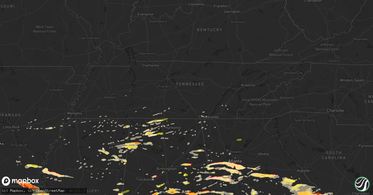
Hail Map in Tennessee on March 18, 2013
Get this storm
March 18 map
$229
one time, instant access
Download today. No call, no setup
Keep the $229
Bought the map and want the full workflow? Apply the entire $229 to a subscription within 7 days. None of it is wasted.
Every map, not just this one
This buys you this map. Subscription and you get every map we run, in the markets you choose from a few cities to whole states to nationwide. Plus real-time alerts the moment a storm fires.
Contact data
Name, contact info, occupancy, even credit band for addresses in the footprint. You go from where it hit to who to call.
Become the source they trust
Unlimited branding weather history reports on demand. You already have the documented answer ready for the property owner, and you are the one who showed up with it.
Property data and RoofTrace estimates
Pull up any address you have got, its value and the exact code rules for that jurisdiction, straight from One Click Code. Then RoofTrace estimates the squares, pitch, and roof value, priced the way you price.
Storm reports in Tennessee
Tennessee
| Date | Description |
|---|---|
| 03/18/20133:30 PM CDT | Tree down near intersection of county rd 796 and 813. |
| 03/18/20133:25 PM CDT | One tree down on bates pike rd. |
| 03/18/20133:00 PM CDT | A few trees down around the chattanooga area. |
| 03/18/201312:31 PM CDT | Roof blown off of a barn at 2780 joe reeves rd just east of culleoka. |
| 03/18/201312:14 PM CDT | Power pole snapped. Trees down and roof damage to a home along manchester rd. Possible tornado damage. |
| 03/18/201312:13 PM CDT | Trees snapped and roof damage to homes along sledge rd. Possible tornado damage. |
| 03/18/201312:12 PM CDT | An nws and ema damage survey revealed that a brief ef0 tornado damaged several outbuildings and blew down approximately 100 trees. Path length 3.8 miles and path width |
| 03/18/201312:12 PM CDT | Minor damage to homes and out buildings along plainview rd. Trees uprooted. Possible tornado damage. |
| 03/18/201312:05 PM CDT | A local report indicates 1.00 inch wind near 8 S PULASKI |
| 03/18/201311:47 AM CDT | An ef0 tornado touched down about 4.6 miles southwest of unionville where a few trees were blown down and a barn damaged on moon bend road. More trees were blown down a |
| 03/18/201311:22 AM CDT | An ef0 tornado touched down on mcknight road east of culleoka where several trees were blown down and one mobile home had minor siding damage. A few more trees were blo |
| 03/18/201311:20 AM CDT | Roof blown off of a barn at 2780 joe reeves rd just east of culleoka. |
| 03/18/20138:21 AM CDT | Trees down along highway 12 |
| 03/18/20138:18 AM CDT | Trees down on neptune road |
| 03/18/20138:07 AM CDT | Trees down along highway 49 east at heath rd. |
| 03/18/20138:04 AM CDT | Nws storm survey found a few trees blown down on bowker road...old lock road...and heath road across northeastern dickson county and on highway 12 in northern cheatham |
| 03/18/20137:53 AM CDT | Tree down along halliburton rd and cedar creek rd. Also a mobile home possibly blown over. |
| 03/18/20137:53 AM CDT | Tree down along halliburton rd and cedar creek rd |
| 03/18/20137:49 AM CDT | Mobile home roof blown off and trees down along hill rd. Possible tornado damage. |
| 03/18/20137:40 AM CDT | A high-end ef1 tornado with max winds around 105 mph touched down in northeastern humphreys county and crossed far southeastern houston county before ending just west o |
| 03/18/20137:37 AM CDT | A high-end ef1 tornado with max winds around 105 mph touched down in northeastern humphreys county and crossed far southeastern houston county before ending in the town |
All States Impacted by Hail Map on March 18, 2013
Cities Impacted by Hail Map on March 18, 2013
- Russellville, AL
- Moulton, AL
- Courtland, AL
- Town Creek, AL
- Mount Hope, AL
- Piedmont, AL
- Jacksonville, AL
- Clanton, AL
- Verbena, AL
- Aberdeen, MS
- Raleigh, MS
- Flora, MS
- Okatie, SC
- Ridgeland, SC
- Montgomery, AL
- Millbrook, AL
- Calera, AL
- Clayton, LA
- Ferriday, LA
- Bogue Chitto, MS
- Ruth, MS
- Smithdale, MS
- Summit, MS
- Natchez, MS
- Sicily Island, LA
- Lumberton, MS
- Bude, MS
- McCall Creek, MS
- Foxworth, MS
- Meadville, MS
- Kokomo, MS
- Columbia, MS
- Mccomb, MS
- Liberty, MS
- Roxie, MS
- Tylertown, MS
- Jayess, MS
- Sandy Hook, MS
- Starkville, MS
- Fayette, MS
- Carrollton, GA
- Carlisle, AR
- Senoia, GA
- Fayetteville, GA
- Richland, MS
- Transylvania, LA
- Lake Providence, LA
- Harvest, AL
- Corinth, MS
- Redwood, MS
- De Kalb, MS
- Daleville, MS
- Rome, GA
- Cedar Bluff, AL
- Newington, GA
- Goodwater, AL
- Prentiss, MS
- Newhebron, MS
- Rocky Face, GA
- Waynesboro, MS
- Swainsboro, GA
- Dublin, GA
- Wrightsville, GA
- Kite, GA
- Tennille, GA
- Adrian, GA
- Toomsboro, GA
- East Dublin, GA
- Irwinton, GA
- Collinsville, MS
- Meridian, MS
- Strong, AR
- Muscle Shoals, AL
- Varnville, SC
- Opelika, AL
- Holly Springs, MS
- Marion, MS
- Laurel, MS
- Bay Springs, MS
- Stringer, MS
- Waynesboro, GA
- State Line, MS
- Prattville, AL
- Marbury, AL
- Monterey, LA
- Rainsville, AL
- Fyffe, AL
- Belzoni, MS
- Athens, AL
- Toney, AL
- Hogansville, GA
- Collins, MS
- Mount Olive, MS
- Seminary, MS
- Monticello, MS
- Pinola, MS
- Ranburne, AL
- Bowdon, GA
- Luthersville, GA
- Greenville, MS
- Kentwood, LA
- Tallapoosa, GA
- Bremen, GA
- Lagrange, GA
- Greenville, GA
- Olive Branch, MS
- Byhalia, MS
- Wilmot, AR
- Jones, LA
- Hamburg, AR
- Newton, MS
- Rose Hill, MS
- Louin, MS
- Pearl, MS
- Jackson, MS
- Flowood, MS
- Cornersville, TN
- Petersburg, TN
- Moreland, GA
- Newnan, GA
- Sharpsburg, GA
- McIntosh, AL
- Harrisville, MS
- Porterville, MS
- Scooba, MS
- Beaufort, SC
- Pell City, AL
- Anniston, AL
- Lincoln, AL
- Riverside, AL
- Eastaboga, AL
- Ragland, AL
- Greensboro, AL
- Newbern, AL
- Marion, AL
- Centreville, AL
- Lawley, AL
- Temple, GA
- Villa Rica, GA
- Waco, GA
- Winston, GA
- Raymond, MS
- Terry, MS
- Byram, MS
- Grantville, GA
- Pisgah, AL
- Henagar, AL
- Deatsville, AL
- Billingsley, AL
- Fort Valley, GA
- Mendenhall, MS
- Braxton, MS
- Clinton, MS
- Hazlehurst, MS
- Georgetown, MS
- Tunica, MS
- Buckatunna, MS
- Silas, AL
- Frankville, AL
- Millry, AL
- Forest, MS
- Decatur, MS
- Walnut Grove, MS
- Union, MS
- Carthage, MS
- Sebastopol, MS
- Philadelphia, MS
- Lena, MS
- Conehatta, MS
- Gay, GA
- Paulding, MS
- Hickory, MS
- Morton, MS
- Pachuta, MS
- Madison, MS
- Lake, MS
- Lawrence, MS
- Canton, MS
- Pulaski, MS
- Brandon, MS
- Ridgeland, MS
- Pelahatchie, MS
- Richland, GA
- Buena Vista, GA
- Cusseta, GA
- Americus, GA
- Plains, GA
- Bartow, GA
- Oak Grove, LA
- Soso, MS
- Douglasville, GA
- Hampton, GA
- Valley Park, MS
- Tyrone, GA
- Jonesboro, GA
- Peachtree City, GA
- Metter, GA
- Greensburg, LA
- Covington, GA
- Mansfield, GA
- Deer Park, AL
- Fruitdale, AL
- Vinegar Bend, AL
- Tibbie, AL
- Walnut, MS
- Houlka, MS
- Vardaman, MS
- Alpine, AL
- Pioneer, LA
- Vidalia, LA
- Jonesville, LA
- Amory, MS
- Fulton, MS
- Trinity, AL
- Abbeville, MS
- Brookhaven, MS
- Alexander City, AL
- Dadeville, AL
- Epps, LA
- Davisboro, GA
- Louisville, GA
- Edwards, MS
- Acme, LA
- Woodville, MS
- Inverness, MS
- Indianola, MS
- Vicksburg, MS
- Magee, MS
- Florence, MS
- Bolton, MS
- Heidelberg, MS
- Woodland, MS
- Stockbridge, GA
- Rex, GA
- Columbus, GA
- Garnett, SC
- Pineland, SC
- Sardis, GA
- Millen, GA
- Sylvania, GA
- Statesboro, GA
- Yemassee, SC
- Wadley, GA
- Midville, GA
- Early Branch, SC
- Garfield, GA
- Twin City, GA
- Clyo, GA
- Tillman, SC
- Estill, SC
- Guyton, GA
- Springfield, GA
- Rocky Ford, GA
- Hardeeville, SC
- Greenwood Springs, MS
- Crosby, MS
- Des Arc, AR
- Weir, MS
- McCool, MS
- Satartia, MS
- Lisman, AL
- Wesson, MS
- Leland, MS
- Isola, MS
- Hollandale, MS
- Hillsboro, AL
- Talladega, AL
- Auburn, AL
- Phenix City, AL
- Fort Benning, GA
- Salem, AL
- Smiths Station, AL
- Tremont, MS
- Hamilton, AL
- Wellington, AL
- Hamilton, GA
- Lester, AL
- Elkmont, AL
- Eatonton, GA
- Randolph, AL
- Mcdonough, GA
- Ellenwood, GA
- Morrow, GA
- Forest Park, GA
- Warthen, GA
- Gibson, GA
- Mitchell, GA
- Avera, GA
- Stapleton, GA
- Wrens, GA
- Brooks, GA
- Malvern, AR
- Silver Creek, MS
- Union Church, MS
- Oak Vale, MS
- Waterproof, LA
- McGehee, AR
- Rohwer, AR
- Monticello, AR
- Dermott, AR
- Arkansas City, AR
- Palmetto, GA
- Whitesburg, GA
- Locust Grove, GA
- Griffin, GA
- Rhine, GA
- Eastman, GA
- Abbeville, GA
- Pitts, GA
- Rochelle, GA
- Cedartown, GA
- Macon, GA
- Sawyerville, AL
- Vienna, GA
- Lauderdale, MS
- Plantersville, AL
- Jones, AL
- Toomsuba, MS
- York, AL
- Cuba, AL
- Detroit, AL
- Marianna, AR
- Gloster, MS
- Georgetown, TN
- Riceville, TN
- Caledonia, MS
- Houston, MS
- Mount Vernon, AL
- Eufaula, AL
- Pittsview, AL
- Omaha, GA
- Falkville, AL
- Somerville, AL
- Hartselle, AL
- Whiteside, TN
- Chattanooga, TN
- Cottondale, AL
- Brookwood, AL
- Vance, AL
- Port Gibson, MS
- Livingston, AL
- Sparta, GA
- Monticello, GA
- Holladay, TN
- Holcomb, MS
- Grenada, MS
- Rogersville, AL
- Anderson, AL
- Thorsby, AL
- Centreville, MS
- Valley, AL
- West Point, GA
- Rison, AR
- Red Bay, AL
- Dutton, AL
- Scottsboro, AL
- Bryant, AL
- Okolona, MS
- Hillsboro, GA
- Franklin, GA
- Roanoke, AL
- Lineville, AL
- Potts Camp, MS
- Lake Village, AR
- Williamson, GA
- Shady Dale, GA
- Jackson, GA
- Flovilla, GA
- Lake Cormorant, MS
- Nesbit, MS
- Aliceville, AL
- Macon, MS
- Daviston, AL
- Hughes, AR
- Hazen, AR
- Smithville, MS
- Baldwyn, MS
- Booneville, MS
- Shannon, MS
- Wadley, AL
- Cragford, AL
- Mayersville, MS
- Brooklet, GA
- Guin, AL
- Rockmart, GA
- Eclectic, AL
- Mize, MS
- Bentonia, MS
- Prairie, MS
- Hackleburg, AL
- Hodges, AL
- Vina, AL
- Phil Campbell, AL
- Madison, AL
- Huntsville, AL
- Port Royal, SC
- Duck Hill, MS
- Ovett, MS
- Marks, MS
- Pickens, AR
- Dumas, AR
- Concord, GA
- Red Banks, MS
- Haleyville, AL
- Waverly, AL
- Lafayette, AL
- Equality, AL
- Camp Hill, AL
- Hamilton, MS
- Sulligent, AL
- Sylacauga, AL
- Guild, TN
- Jasper, TN
- Woodville, AL
- New Hope, AL
- Red Oak, GA
- Union City, GA
- Fairburn, GA
- Conley, GA
- Atlanta, GA
- Barnesville, GA
- Forsyth, GA
- Flat Rock, AL
- Crossett, AR
- Bonita, LA
- Calhoun, TN
- Delano, TN
- Rienzi, MS
- Milner, GA
- Maplesville, AL
- Union Springs, AL
- Banks, AL
- Shorter, AL
- Hardaway, AL
- Sturgis, MS
- Vernon, AL
- Taylorsville, MS
- Lizella, GA
- Preston, GA
- Andersonville, GA
- Ellaville, GA
- Byromville, GA
- Gurley, AL
- Chatom, AL
- Pontotoc, MS
- Tallassee, AL
- Steele, AL
- Shuqualak, MS
- Middleton, TN
- Ohatchee, AL
- Freeport, FL
- Sondheimer, LA
- West Blocton, AL
- Rockford, AL
- Jemison, AL
- Cherokee, AL
- Tuscumbia, AL
- Midway, AL
- Falkner, MS
- Tiplersville, MS
- Rolling Fork, MS
- Rutledge, GA
- Riverdale, GA
- Cullman, AL
- Holly Pond, AL
- Gadsden, AL
- Centre, AL
- Hatchechubbee, AL
- Seale, AL
- Florala, AL
- Crossville, AL
- Boaz, AL
- Albertville, AL
- Camden, AL
- Hernando, MS
- Robinsonville, MS
- Utica, MS
- Pine Hill, AL
- Cedarbluff, MS
- Ellisville, MS
- Dallas, GA
- Athens, TN
- Woodland, GA
- Newborn, GA
- Coy, AL
- Sandersville, GA
- Keysville, GA
- Delta, AL
- Woodland, AL
- Wedowee, AL
- Hattiesburg, MS
- Hermanville, MS
- Chickamauga, GA
- Minter, AL
- Tuskegee, AL
- Five Points, AL
- Lanett, AL
- Cusseta, AL
- Stewart, MS
- French Camp, MS
- Warren, AR
- Wilmar, AR
- New Edinburg, AR
- Acworth, GA
- Ripley, MS
- McCalla, AL
- Bastrop, LA
- Crystal Springs, MS
- Spruce Pine, AL
- Ponce De Leon, FL
- Winona, MS
- De Valls Bluff, AR
- Clarendon, AR
- Randolph, MS
- Valhermoso Springs, AL
- Little Rock, MS
- Munford, AL
- Wetumpka, AL
- Heflin, AL
- Carrollton, MS
- McCarley, MS
- Leighton, AL
- Stockton, AL
- Wagarville, AL
- Jackson, AL
- Claxton, GA
- Register, GA
- Cobbtown, GA
- Dumas, MS
- Menlo, GA
- Valley Head, AL
- Rising Fawn, GA
- Meridianville, AL
- Selma, AL
- Whitwell, TN
- Talbotton, GA
- Lookout Mountain, GA
- Trenton, GA
- Wildwood, GA
- Troy, AL
- Glenwood, AL
- Ashland, MS
- Tuscaloosa, AL
- Tishomingo, MS
- Iuka, MS
- Florence, AL
- Guntown, MS
- Blue Springs, MS
- Saltillo, MS
- Little Rock, AR
- Darden, TN
- Lexington, TN
- Scott, AR
- Richton, MS
- Emelle, AL
- Weogufka, AL
- Water Valley, MS
- Santa Rosa Beach, FL
- Bessemer, AL
- Birmingham, AL
- Jenkinsburg, GA
- Columbus, MS
- Burnsville, MS
- Bismarck, AR
- Beaverton, AL
- Nettleton, MS
- Bear Creek, AL
- Myrtle, MS
- Gordon, GA
- Jeffersonville, GA
- Notasulga, AL
- Houston, AL
- Double Springs, AL
- Kennesaw, GA
- Zebulon, GA
- Hanceville, AL
- Bremen, AL
- Hayden, AL
- Belden, MS
- Tupelo, MS
- Laceys Spring, AL
- Decatur, AL
- Louisville, MS
- Milledgeville, GA
- Dry Branch, GA
- Gilbertown, AL
- Itta Bena, MS
- Marksville, LA
- Effie, LA
- Chunky, MS
- West Point, MS
- Steens, MS
- Whiteville, TN
- Ackerman, MS
- Aubrey, AR
- Moro, AR
- Pulaski, TN
- Langston, AL
- Jena, LA
- Green Pond, SC
- Mantachie, MS
- Madison, GA
- Milan, GA
- Cruger, MS
- Coahoma, MS
- Graham, AL
- Lawrenceburg, TN
- Titus, AL
- Grand Junction, TN
- Saulsbury, TN
- Ethel, MS
- Plantersville, MS
- Lumpkin, GA
- Donaldson, AR
- Culloden, GA
- Eupora, MS
- Pine Mountain, GA
- Shiloh, GA
- Pine Mountain Valley, GA
- Conyers, GA
- Matthews, GA
- Marietta, GA
- Golden, MS
- Waynesboro, TN
- Waverly Hall, GA
- Cataula, GA
- Jacksons Gap, AL
- Kellyton, AL
- Altoona, AL
- Tanner, AL
- Boligee, AL
- Bonifay, FL
- Caryville, FL
- Defuniak Springs, FL
- Summerville, GA
- Owens Cross Roads, AL
- Senatobia, MS
- Shelby, AL
- Enterprise, MS
- Vossburg, MS
- Shubuta, MS
- Tallulah, LA
- Tougaloo, MS
- Leola, AR
- Deville, LA
- Hickory Flat, MS
- Castleberry, AL
- Evergreen, AL
- Ashland, AL
- Dundee, MS
- Northport, AL
- Roberta, GA
- Knoxville, GA
- Musella, GA
- West, MS
- Faunsdale, AL
- Moselle, MS
- Westville, FL
- Roopville, GA
- Frankewing, TN
- Allendale, SC
- Fairfax, SC
- Pembroke, GA
- Collinwood, TN
- Cordele, GA
- Gurdon, AR
- Trussville, AL
- Box Springs, GA
- Saint Stephens, AL
- Thomasville, AL
- Glen, MS
- Sardis, AL
- Brent, AL
- Ward, AL
- Prospect, TN
- Goodspring, TN
- Leoma, TN
- Epes, AL
- Brierfield, AL
- Montevallo, AL
- Quitman, MS
- Niceville, FL
- Gallion, AL
- Reynolds, GA
- Muscadine, AL
- Lexington, AL
- Killen, AL
- Little River, AL
- Blythe, GA
- Brooksville, MS
- Lynn, AL
- Prescott, AR
- Yatesville, GA
- Ardmore, AL
- Tillar, AR
- Forkland, AL
- Demopolis, AL
- Dawsonville, GA
- Ball Ground, GA
- Gainesville, AL


