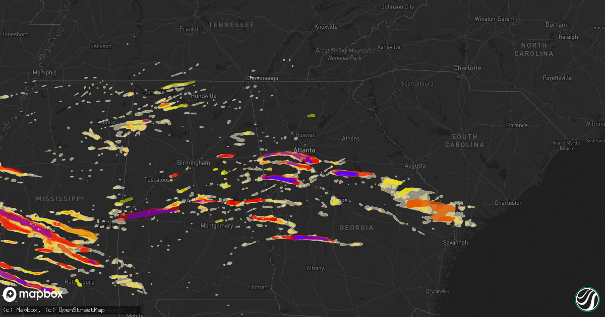
Hail Map on March 18, 2013
Get this storm
March 18 map
$229
one time, instant access
Download today. No call, no setup
Keep the $229
Bought the map and want the full workflow? Apply the entire $229 to a subscription within 7 days. None of it is wasted.
Every map, not just this one
This buys you this map. Subscription and you get every map we run, in the markets you choose from a few cities to whole states to nationwide. Plus real-time alerts the moment a storm fires.
Contact data
Name, contact info, occupancy, even credit band for addresses in the footprint. You go from where it hit to who to call.
Become the source they trust
Unlimited branding weather history reports on demand. You already have the documented answer ready for the property owner, and you are the one who showed up with it.
Property data and RoofTrace estimates
Pull up any address you have got, its value and the exact code rules for that jurisdiction, straight from One Click Code. Then RoofTrace estimates the squares, pitch, and roof value, priced the way you price.
States Impacted by Hail Map on March 18, 2013
Storm reports
Tennessee
| Date | Description |
|---|---|
| 03/18/20133:30 PM CDT | Tree down near intersection of county rd 796 and 813. |
| 03/18/20133:25 PM CDT | One tree down on bates pike rd. |
| 03/18/20133:00 PM CDT | A few trees down around the chattanooga area. |
| 03/18/201312:31 PM CDT | Roof blown off of a barn at 2780 joe reeves rd just east of culleoka. |
| 03/18/201312:14 PM CDT | Power pole snapped. Trees down and roof damage to a home along manchester rd. Possible tornado damage. |
| 03/18/201312:13 PM CDT | Trees snapped and roof damage to homes along sledge rd. Possible tornado damage. |
| 03/18/201312:12 PM CDT | Minor damage to homes and out buildings along plainview rd. Trees uprooted. Possible tornado damage. |
| 03/18/201312:12 PM CDT | An nws and ema damage survey revealed that a brief ef0 tornado damaged several outbuildings and blew down approximately 100 trees. Path length 3.8 miles and path width |
| 03/18/201312:05 PM CDT | A local report indicates 1.00 inch wind near 8 S PULASKI |
| 03/18/201311:47 AM CDT | An ef0 tornado touched down about 4.6 miles southwest of unionville where a few trees were blown down and a barn damaged on moon bend road. More trees were blown down a |
| 03/18/201311:22 AM CDT | An ef0 tornado touched down on mcknight road east of culleoka where several trees were blown down and one mobile home had minor siding damage. A few more trees were blo |
| 03/18/201311:20 AM CDT | Roof blown off of a barn at 2780 joe reeves rd just east of culleoka. |
| 03/18/20138:21 AM CDT | Trees down along highway 12 |
| 03/18/20138:18 AM CDT | Trees down on neptune road |
| 03/18/20138:07 AM CDT | Trees down along highway 49 east at heath rd. |
| 03/18/20138:04 AM CDT | Nws storm survey found a few trees blown down on bowker road...old lock road...and heath road across northeastern dickson county and on highway 12 in northern cheatham |
| 03/18/20137:53 AM CDT | Tree down along halliburton rd and cedar creek rd |
| 03/18/20137:53 AM CDT | Tree down along halliburton rd and cedar creek rd. Also a mobile home possibly blown over. |
| 03/18/20137:49 AM CDT | Mobile home roof blown off and trees down along hill rd. Possible tornado damage. |
| 03/18/20137:40 AM CDT | A high-end ef1 tornado with max winds around 105 mph touched down in northeastern humphreys county and crossed far southeastern houston county before ending just west o |
| 03/18/20137:37 AM CDT | A high-end ef1 tornado with max winds around 105 mph touched down in northeastern humphreys county and crossed far southeastern houston county before ending in the town |
Louisiana
| Date | Description |
|---|---|
| 03/18/20136:38 PM CDT | A local report indicates 1.25 inch wind near 3 NNE HOLLOWAY |
| 03/18/20132:45 PM CDT | A couple windows blown out of a house and a truck from the hail. |
| 03/18/20132:36 PM CDT | Reported via facebook |
| 03/18/20132:30 PM CDT | Reported via facebook |
| 03/18/20132:19 PM CDT | A local report indicates 1.00 inch wind near 5 E PIONEER |
| 03/18/20132:07 PM CDT | A local report indicates 1.75 inch wind near OAK GROVE |
| 03/18/20131:45 PM CDT | A couple windows blown out of a house and a truck from the hail. |
| 03/18/20131:42 PM CDT | Golfball to baseball sized hail reported via facebook |
| 03/17/20137:12 PM CDT | In the parhams community |
Alabama
| Date | Description |
|---|---|
| 03/18/20136:17 PM CDT | A local report indicates 1.50 inch wind near 3 NW PHENIX CITY |
| 03/18/20136:17 PM CDT | A local report indicates 1.25 inch wind near PHENIX CITY |
| 03/18/20136:14 PM CDT | Up to 2 inch hail covering the ground. Hail fell for 10 minutes. |
| 03/18/20136:12 PM CDT | Average size of the hail was 1.25 inches...with the largest hail size being 2 inches. The hail completely covered the ground. |
| 03/18/20136:08 PM CDT | A local report indicates 1.75 inch wind near 5 WNW PHENIX CITY |
| 03/18/20135:45 PM CDT | Hail ranged from 0.25 to 1 inch in diameter. |
| 03/18/20135:40 PM CDT | Hail measured and pictured of 2.5 to 3 inches just south of salem in southern lee county. |
| 03/18/20135:30 PM CDT | Several trees were blown door in millbrook. |
| 03/18/20135:25 PM CDT | Hail up to quarters observed. A funnel cloud was also see at state route 51. Winds were 55 to 60 mph...with no damage from the winds. |
| 03/18/20135:13 PM CDT | Reported near still waters resort. Time estimated from radar. |
| 03/18/20135:10 PM CDT | Trees down in new site. Winds measured 49 mph in alex city. |
| 03/18/20135:02 PM CDT | One inch to one and three quarters inch hail reported along interstate 65 between mile markers 193 and 197. |
| 03/18/20135:00 PM CDT | Hail up to the size of golf balls fell for 15 minutes |
| 03/18/20134:59 PM CDT | Quarter sized hail reported at childrens harbor |
| 03/18/20134:58 PM CDT | A local report indicates 1.00 inch wind near 3 ESE NOTASULGA |
| 03/18/20134:57 PM CDT | Quarter sized hail reported at childrens harbor |
| 03/18/20134:55 PM CDT | A local report indicates 1.00 inch wind near 5 SSE YORK |
| 03/18/20134:54 PM CDT | A local report indicates 1.75 inch wind near 6 SW DADEVILLE |
| 03/18/20134:53 PM CDT | A local report indicates 1.25 inch wind near LANETT |
| 03/18/20134:53 PM CDT | A local report indicates 1.00 inch wind near VALLEY |
| 03/18/20134:37 PM CDT | One business lost its roof on 32nd street sw. |
| 03/18/20134:34 PM CDT | One inch hail covering the ground at the rest area along highway 82. |
| 03/18/20134:34 PM CDT | Reported near sprott. Time estimated from radar. |
| 03/18/20134:28 PM CDT | Power lines down |
| 03/18/20134:27 PM CDT | Trees and power lines down. |
| 03/18/20134:22 PM CDT | Trees and power lines down neary hwy 49 and abel rd. |
| 03/18/20134:22 PM CDT | Hail up to quarters fell as well as several trees blown down...blocking main street and hwy 9. |
| 03/18/20134:21 PM CDT | A local report indicates 1.75 inch wind near STURKIE |
| 03/18/20134:16 PM CDT | Quarter size hail fell for 5 minutes during the storm. |
| 03/18/20134:14 PM CDT | Hail lasted for ten minutes with up to quarters observed. |
| 03/18/20134:13 PM CDT | A local report indicates 1.25 inch wind near CAMP HILL |
| 03/18/20134:11 PM CDT | Roof of acker electric co building partially removed. Winds estimated at 70-80 mph by trained nws spotter. |
| 03/18/20134:09 PM CDT | Roof damage to campus inn |
| 03/18/20134:08 PM CDT | Trees down on hwy 35 near dekalb county line |
| 03/18/20134:05 PM CDT | A roof was blown off a residence on mcelderry road and a tree fell on a house facing mitchell street adjacent to munford town hall. |
| 03/18/20134:05 PM CDT | A few trees reported down along cr 10...one blocking a portion of the road. Time estimated from radar. |
| 03/18/20134:05 PM CDT | Roof off barn on yancy drive |
| 03/18/20134:05 PM CDT | Trees and power lines down here and in munford on priebes road and grant town road. |
| 03/18/20134:03 PM CDT | Three of four trees were down on houses and several roads blocked. Cherry street...taylors mill road... Mountain view road...and east street south were are blocked or p |
| 03/18/20134:03 PM CDT | The roof of the library at jacksonville state was partially removed. The transmitter for the radio station on the roof was destroyed. |
| 03/18/20134:00 PM CDT | Tree down on a house on cr 479 near kilpatrick. |
| 03/18/20134:00 PM CDT | Anemometer registered 88 mph prior to losing a cup. Numerous trees and powerlines down. |
| 03/18/20134:00 PM CDT | Three of four trees were sown on houses and several roads blocked. Cherry street...taylors mill road... Mountain view road...and east street south were are blocked or p |
| 03/18/20133:57 PM CDT | Exit 212 on i65 |
| 03/18/20133:57 PM CDT | Trees on house. Residents trapped. |
| 03/18/20133:56 PM CDT | Large tree uprooted. |
| 03/18/20133:56 PM CDT | Tree on house on silverwood drive with entrapment |
| 03/18/20133:56 PM CDT | At least quarter size hail near centreville. Time estimated from radar. |
| 03/18/20133:55 PM CDT | Quarter sized hail reported in skirum |
| 03/18/20133:55 PM CDT | A local report indicates 2.00 inch wind near LINCOLN |
| 03/18/20133:55 PM CDT | Roof damage to collinsville high school gym and roof damage to national guard armory. |
| 03/18/20133:55 PM CDT | Outbuilding destroyed near county schools coliseum east of rainsville |
| 03/18/20133:55 PM CDT | Power lines and trees down in skirum |
| 03/18/20133:54 PM CDT | Spotter reported gutters and signs blown down between rainsville and fyffe. Numerous trees down including cedar trees. Roof off a barn. Roof damage to a house on jolley |
| 03/18/20133:54 PM CDT | Spotter reports power poles snapped and at least one barn destroyed at this location west of rainsville. |
| 03/18/20133:54 PM CDT | Spotter reports several roads blocked due to downed trees. Chicken houses heavily damaged on cr50. Trees snapped and power lines down on cr 50. |
| 03/18/20133:53 PM CDT | A local report indicates 1.00 inch wind near ODENVILLE |
| 03/18/20133:53 PM CDT | Chicken house roof blown off and trees down |
| 03/18/20133:52 PM CDT | Structural damage to a house on county road 406 near dutton. |
| 03/18/20133:52 PM CDT | A mobile home was blown off of the foundation on county rd 162. Time estimated from radar. |
| 03/18/20133:52 PM CDT | Approximately 20 trees down on al hwy 77 |
| 03/18/20133:52 PM CDT | Part of roof blown off of a church on county rd 16 |
| 03/18/20133:51 PM CDT | At least 3 inch hail reported at the state eoc. |
| 03/18/20133:51 PM CDT | Numerous trees were down and damage to one residence. |
| 03/18/20133:51 PM CDT | An ef2 tornado touched down along cr 539 north of cr 50 in dekalb county in the fyffe and shiloh communities. The most significant damage with this tornado occurred alo |
| 03/18/20133:50 PM CDT | Tree on house on rainbow drive with entrapment |
| 03/18/20133:50 PM CDT | Just south of exit 212 on i65. Corrected for location and time. |
| 03/18/20133:48 PM CDT | Hail observed between 2.25 and 2.5 inches in diameter near the walmart in clanton. |
| 03/18/20133:46 PM CDT | Golf ball size hail was reported on depot street...as well as trees down. Some were snapped others uprooted...but all were facing the same direction. |
| 03/18/20133:46 PM CDT | Multiple trees down stouts road elkwood rd |
| 03/18/20133:46 PM CDT | An airport hanger door was blown in and damaged an airplane at the st clair county airport |
| 03/18/20133:46 PM CDT | Trees down cr41 and walnut grove rd. Trailer blown over on walnut grove rd. Correction. Well house blown onto trailer |
| 03/18/20133:45 PM CDT | According to pell city schools...duran jr high school sustained roof damage. The roof of the press box at the football field was also damaged. |
| 03/18/20133:45 PM CDT | 3 or 4 trailers were damaged at al hwy 68 and al 168 |
| 03/18/20133:43 PM CDT | *** 3 inj *** an ef1 tornado with winds of 95-105 mph touched down in marshall county and moved eastward into north etowah county. The tornado downed hundreds of trees. |
| 03/18/20133:42 PM CDT | Trees down and houses damaged in a 5 by 8 block in boaz near hwy 205 |
| 03/18/20133:41 PM CDT | Metal roofing was removed from a chicken house along highway 132. Winds est at 80 mph. |
| 03/18/20133:41 PM CDT | A dozen trees were uprooted and metal roofing was removed from a portion of a home along highway 132. Winds est at 80 mph. |
| 03/18/20133:41 PM CDT | *** 7 inj *** an ef2 tornado touched down on hambey road just east of mcville road in marshall county and tracked east into dekalb county. The most significant tornado |
| 03/18/20133:41 PM CDT | *** 3 inj *** the tornado initially touched down just east of u.s. Hwy 431 in boaz just south of bruce road with some minor structural damage to businesses along hwy 43 |
| 03/18/20133:40 PM CDT | 3 buildings damaged including a roof blown off. A road was blocked due to this damage. |
| 03/18/20133:40 PM CDT | Several pine trees were snapped and a mobile home overturned. Winds est at 70 mph. |
| 03/18/20133:39 PM CDT | A wind damage swath 600 yds long and 150 yds wide downed approx 4 dozen trees along the northwest shore of doctor jenkins lake. Winds est at 85 mph. |
| 03/18/20133:37 PM CDT | Damage to 3 structures on hwy 431 and rose road. Extent of damage unknown at this time. |
| 03/18/20133:35 PM CDT | Via emergency management |
| 03/18/20133:35 PM CDT | Downed trees across the county. Alabama hwy 171 was blocked for 30 minutes due to trees down. |
| 03/18/20133:34 PM CDT | Numerous trees down in the 1600 block of park avenue and acton road. |
| 03/18/20133:33 PM CDT | Couple pine trees snapped and powerlines down along ridgewood drive. Time estimated from radar. |
| 03/18/20133:32 PM CDT | Several trees were down across the area. |
| 03/18/20133:30 PM CDT | Some trees fell in argo across us 11. |
| 03/18/20133:30 PM CDT | Numerous trees down. Wind gusts in excess of 55 mph reported. |
| 03/18/20133:30 PM CDT | Numerous trees down. Estimated wind gusts in excess of 55 mph. |
| 03/18/20133:30 PM CDT | Trees on hour 2184 self creek rd center point. Additional trees clayton rd and old springville rd in clay. |
| 03/18/20133:29 PM CDT | Roof damage to home |
| 03/18/20133:28 PM CDT | Reported near abernant. Time estimated from radar. |
| 03/18/20133:28 PM CDT | Trees down and shingles off roof |
| 03/18/20133:28 PM CDT | Structural damage to a business in town |
| 03/18/20133:27 PM CDT | Large tree down with roof damage on several homes. Power lines down as well. |
| 03/18/20133:24 PM CDT | On hwy 79 at mile marker 118...trees blocking all lanes of highway. |
| 03/18/20133:23 PM CDT | A tree was uprooted in front of moore hall near the quad. |
| 03/18/20133:22 PM CDT | Trees down around bill jones road. Tin roof was blown off a vacant manufactured home just off old sardis road. |
| 03/18/20133:22 PM CDT | Trees down in town |
| 03/18/20133:20 PM CDT | Trees and power lines down |
| 03/18/20133:20 PM CDT | Quarter sized hail reported. |
| 03/18/20133:20 PM CDT | Taylors ferry and warrior river rd at union hill church |
| 03/18/20133:18 PM CDT | Trees down on cr 47 near the cullman county line. |
| 03/18/20133:17 PM CDT | Multiple trees down near stouts road and elkwood rd. |
| 03/18/20133:16 PM CDT | Trees down on hwy 160 near cr 13 |
| 03/18/20133:14 PM CDT | Trees down on hwy 91 |
| 03/18/20133:12 PM CDT | Dozen pine trees down in town. |
| 03/18/20133:10 PM CDT | Dozen large pine trees down pointing in a uniform direction. |
| 03/18/20133:10 PM CDT | Roof damage to a mobile home on shaw road. |
| 03/18/20133:09 PM CDT | Power lines down near crosshaven church on hwy 31 |
| 03/18/20133:09 PM CDT | Multiple trees down on cr 747 between hwy 91 and cr 703 |
| 03/18/20133:07 PM CDT | 2 large trees damaged. Time estimated from radar. |
| 03/18/20133:06 PM CDT | Trees down on mt. View road. |
| 03/18/20133:06 PM CDT | Trees blown down. |
| 03/18/20133:05 PM CDT | Trees down on a mobile home. Cr265 in town creek. |
| 03/18/20132:46 PM CDT | Trees and power lines down |
| 03/18/20132:46 PM CDT | Trees down with roads blocked in numerous locations. 2 manufactured homes overturned in dogwood acres. |
| 03/18/20132:41 PM CDT | Numerous trees blown down blocking highway 33. |
| 03/18/20132:36 PM CDT | Several large trees snapped along al hwy 5 near the lupton school...with trees down and blocking prospect road near hwy 5 and damaging a house. |
| 03/18/20132:36 PM CDT | Wood storage building and two car metal garage destroyed at the intersection of cr 244/157. |
| 03/18/20132:35 PM CDT | Measured 63 mph wind gust at courtland airport /awos/. |
| 03/18/20132:35 PM CDT | Six large wooden power poles snapped/knocked down. |
| 03/18/20132:27 PM CDT | Trees down and transformers blown in town. |
| 03/18/20132:27 PM CDT | Tree across road with phone and power lines down at the road intersection of oakmont trail and log cabin trail. |
| 03/18/20132:26 PM CDT | Multiple trees blown down and blocking hatton school road. |
| 03/18/20132:26 PM CDT | Trees down across hwy 171 near the intersection of hwy 159 on the south end of town. |
| 03/18/20132:25 PM CDT | Trees down in town |
| 03/18/20132:25 PM CDT | Quarter sized hail reported by fire department. Winds reported to 40 mph. |
| 03/18/20132:24 PM CDT | Trees and power lines down |
| 03/18/20132:20 PM CDT | A portable garage blown up into a tree on foster mill road. |
| 03/18/20132:20 PM CDT | Trees blown down and blocking the road. Intersection of cr 70/570. |
| 03/18/20132:20 PM CDT | Trees and power lines down. |
| 03/18/20132:18 PM CDT | Quarter sized hail near the intersection of hwy 99 and tillman mill. |
| 03/18/20132:18 PM CDT | Trees and power lines down throughout town. Some building damage but unknown quantity at this time. |
| 03/18/20132:15 PM CDT | Trees blown down and minor roof damage to several small buildings in the bear creek area. |
| 03/18/20132:13 PM CDT | At the eoc |
| 03/18/20132:12 PM CDT | Quarter size hail was reported. |
| 03/18/20132:11 PM CDT | Tree down on a structure on college avenue. |
| 03/18/20132:10 PM CDT | Dozen large pine trees down pointing in a uniform direction. |
| 03/18/20132:10 PM CDT | Quarter sized hail at 4th and 11th in decatur. |
| 03/18/20132:09 PM CDT | Trees and power lines down |
| 03/18/20132:08 PM CDT | Trees down on house. |
| 03/18/20132:06 PM CDT | Tree down blocking the road near the sheffield city hall. |
| 03/18/20132:04 PM CDT | *** 1 inj *** estimated winds of 50-60 mph. Numerous powerlines and trees down in town. Several homes damaged. Two destroyed. One tree landed on a car and trapped an in |
| 03/18/20132:02 PM CDT | Trees and power line down |
| 03/18/20131:55 PM CDT | A local report indicates 1.75 inch wind near BEXAR |
| 03/18/20131:50 PM CDT | Quarter size hail reported at the intersection of al hwy 24 and county road 434 northeast of moulton. |
| 03/18/20131:48 PM CDT | Electrical lines down on residence near barton. Time estimated from radar. |
| 03/18/20131:47 PM CDT | Structural damage reported by emergency management along highway 190. Time estimated from radar. |
| 03/18/20131:46 PM CDT | Quarter sized hail reported in downtown moulton. |
| 03/18/20131:45 PM CDT | Trees and powerlines down around red bay. Along highway 19 and 11 north and south of town. Time estimated from radar. |
| 03/18/20131:40 PM CDT | Tree down across road at allsboro...5 miles south of hwy 72. Time estimated from radar. |
| 03/18/20131:38 PM CDT | A local report indicates 1.75 inch wind near HACKLEBURG |
| 03/18/20131:25 PM CDT | At the intersection of cr 20 and 25. |
| 03/18/20131:18 PM CDT | Silver dollar sized hail reported in hatton |
| 03/17/20137:21 PM CDT | Significant portion of metal roof removed from a residence along cr 20. Time estimated from radar. |
Florida
| Date | Description |
|---|---|
| 03/18/20135:10 AM CDT | Emergency manager reports power lines down along u.s. Highway 27 in branford and highway is temporarily closed. |
South Carolina
| Date | Description |
|---|---|
| 03/18/20136:09 PM CDT | Trees down at bluff road and heyward st. |
| 03/17/201310:14 PM CDT | Tree down at 1100 block of orangeburg road. |
| 03/17/201310:01 PM CDT | A local report indicates 1.00 inch wind near 1 NNW PORT ROYAL |
| 03/17/201310:00 PM CDT | Power line down at 1200 block of ridge road |
| 03/17/20139:48 PM CDT | Sc highway patrol reports a tree down and in the roadway on hendersonville highway about 2 miles south of hendersonville. |
| 03/17/20139:46 PM CDT | Tree down between the 4000 and 5000 block of combahee road |
| 03/17/20139:41 PM CDT | Tree down on dukes street. |
| 03/17/20139:40 PM CDT | Sc highway patrol reports a tree down and in the roadway on lowcountry highway near hw-17a. |
| 03/17/20139:38 PM CDT | Sc highway patrol reports a tree down and in the roadway in the 3700 block of bellinger hill road. |
| 03/17/20139:36 PM CDT | Tree down near coolers grocery on coosaw scenic drive. |
| 03/17/20139:36 PM CDT | Sc highway patrol reports a tree down and in the roadway on hw-15 between i-26 and hw-178. |
| 03/17/20139:25 PM CDT | Sc highway patrol reports a tree down and in the roadway on hw-278 near rock spring road. |
| 03/17/20139:25 PM CDT | Sc highway patrol reports a tree down and in the roadway on hw-68 near hw-278. |
| 03/17/20139:25 PM CDT | Sc highway patrol reports a tree down and in the roadway on edward mixon road near hw-68. |
| 03/17/20139:17 PM CDT | Sc highway patrol reports a tree down and in the roadway on hope well road near two sisters ferry road. |
| 03/17/20139:17 PM CDT | Hail slightly larger than quarters falling near the intersection of turner expressway and hw-3. |
| 03/17/20139:17 PM CDT | Trees down at pearson road and old stone road. |
| 03/17/20139:15 PM CDT | Tree down on aiken avenue south. |
| 03/17/20139:12 PM CDT | Sc highway patrol reports a tree down and in the roadway on tinker town road near hw-278. |
| 03/17/20139:10 PM CDT | Tree down on two power poles. |
| 03/17/20139:08 PM CDT | Sc highway patrol reports a tree down and in the roadway on luray highway near hope well road. |
| 03/17/20139:05 PM CDT | Tree down at barton street and flat street. |
| 03/17/20138:59 PM CDT | A local report indicates 1.00 inch wind near SCOTIA |
| 03/17/20138:59 PM CDT | Tree down at river road and chess loop. |
| 03/17/20138:41 PM CDT | Sc highway patrol reported trees down on gardner farm road. |
| 03/17/20138:37 PM CDT | Trees down at mccords ferry rpad and old mcgraw road. |
| 03/17/20138:28 PM CDT | Trees down at leesburg road and harmon road. |
| 03/17/20138:25 PM CDT | Trees down at leesburg rd. And trotter rd. |
| 03/17/20138:11 PM CDT | Sc highway patrol reported trees down on kitty hawk drive. |
| 03/17/20137:06 PM CDT | Trees down on screaming eagle road near melton rd. |
| 03/17/20137:05 PM CDT | Trees down near wagener. |
| 03/17/20137:04 PM CDT | Trees down leesburg road and ulmer road |
Arkansas
| Date | Description |
|---|---|
| 03/18/20131:28 PM CDT | Reported along ashley county road 25 near louisiana state line |
| 03/18/20131:23 PM CDT | A local report indicates 1.75 inch wind near CROSSETT |
| 03/18/20131:02 PM CDT | Quarter sized hail fell on highway 4 west of arkansas city. |
| 03/18/201312:47 PM CDT | A local report indicates 1.00 inch wind near MCGEHEE |
| 03/18/201312:45 PM CDT | Quarter sized hail was reported in dermott. |
Georgia
| Date | Description |
|---|---|
| 03/18/20136:54 PM CDT | Tree down on a mobile home nerar byron. |
| 03/18/20136:45 PM CDT | Numerous trees down across county. |
| 03/18/20136:42 PM CDT | Kmcn asos measured 52kt gust. |
| 03/18/20136:40 PM CDT | Numerous trees and powerlines down across the city. Several trees are on homes with people trapped. |
| 03/18/20136:37 PM CDT | Numerous trees and powerlines down in lake wildwood subdivision...1 mile west of i475. Media also reported the press box at the first presbyterian day school on calvin |
| 03/18/20136:36 PM CDT | The fort benning emergency manager estimated wind gusts to 60 mph that caused damage to several trees on this portion of the military reservation. Dime-sized hail was a |
| 03/18/20136:36 PM CDT | The fort benning emergency manager estimated wind gusts to 60 mph that caused damage to several trees on this portion of the military reservation. Dime-sized hail was a |
| 03/18/20136:30 PM CDT | Numerous trees down across county. |
| 03/18/20136:20 PM CDT | Monroe county em relayed a report trees down countywide along with a car accident caused by the weather. |
| 03/18/20136:15 PM CDT | Public reported golf ball sized hail north of americus. |
| 03/18/20136:15 PM CDT | A local report indicates 1.00 inch wind near COLUMBUS |
| 03/18/20136:15 PM CDT | Golfball sized hail reported in the mansfield area. |
| 03/18/20136:14 PM CDT | Up to 2 inch hail covering the ground. Hail fell for 10 minutes. |
| 03/18/20136:11 PM CDT | A local report indicates 1.00 inch wind near 2 N AMERICUS |
| 03/18/20136:10 PM CDT | Public reported the size of golfball sized hail in eatonton. The hail was so deep it covered the ground completly. |
| 03/18/20136:08 PM CDT | Public reported golfball sized hail damaged a windshield of a car on u.s. Highway 19 northwest of americus. |
| 03/18/20136:00 PM CDT | Trees and powerlines were blown down countywide...particularly in the yatesville area. |
| 03/18/20135:59 PM CDT | Butts county em relayed a report of trees down countywide along with numerous powerlines down. Tree damage was especially heavy near flovilla. |
| 03/18/20135:55 PM CDT | Lasted 20 minutes...hail up to golfball sized hail. |
| 03/18/20135:50 PM CDT | A local report indicates 1.75 inch wind near MCDONOUGH |
| 03/18/20135:50 PM CDT | *** 1 fatal *** several trees were blown down near georgia highway 36. At least one tree blocked a portion of the highway. A motorist swerved to avoid the tree and lost |
| 03/18/20135:49 PM CDT | Numerous trees down throughout harris county. |
| 03/18/20135:45 PM CDT | Widespread dime-sized hail covered the ground along georgia highway 30 with some of the hailstones as large as golfballs. |
| 03/18/20135:40 PM CDT | Hail ranging from one to two inches reported in southern clayton county. |
| 03/18/20135:40 PM CDT | Reported by former nws employee |
| 03/18/20135:39 PM CDT | Quarter sized hail reported in hampton. |
| 03/18/20135:31 PM CDT | Pike county emergency manager and broadcast media reported damage on caldwell bridge road. A home sustained minor roof damage...had both doors blown out...and four fron |
| 03/18/20135:30 PM CDT | Tennis ball sized hail reported in fayetteville. |
| 03/18/20135:30 PM CDT | The public relayed a report of baseball sized hail in stockbridge. |
| 03/18/20135:25 PM CDT | A nws survey team determined an ef-2 tornado touched down in meriwether county and moved into pike county. A home sustained minor roof damage...had both doors blown out |
| 03/18/20135:25 PM CDT | A local report indicates 1.00 inch wind near FAYETTEVILLE |
| 03/18/20135:25 PM CDT | Along mask road fayetteville. |
| 03/18/20135:25 PM CDT | Numerous trees were blown down on elders mill road. |
| 03/18/20135:25 PM CDT | A local report indicates 1.00 inch wind near DAWSONVILLE |
| 03/18/20135:15 PM CDT | Baseball sized hail reported in stockbridge. |
| 03/18/20135:13 PM CDT | A local report indicates 1.50 inch wind near 2 N STOCKBRIDGE |
| 03/18/20135:12 PM CDT | Numerous reports of damage from hail in luthersville |
| 03/18/20135:12 PM CDT | A few trees were blown down or snapped in the woodstock area. |
| 03/18/20135:10 PM CDT | An ef2 tornado with wind speeds up to 120 mph touched down near rocky mount road and caldwell road in meriwether county. It traveled east to southeast before lifting on |
| 03/18/20135:10 PM CDT | Coweta county em relayed a report of trees down all across the county. |
| 03/18/20135:10 PM CDT | Harris county 911 relayed a report of numerous trees down near whitesville. |
| 03/18/20135:10 PM CDT | A nws employee in the summer grove subdivision estimated a wind gust to 60 mph. |
| 03/18/20135:10 PM CDT | Coweta county em relayed a report of trees down all across the county. |
| 03/18/20135:04 PM CDT | Golfball sized-hail occurred and numerous trees and power lines were blown down in the lithia springs area. Three vehicles were damaged by hail and three were damaged b |
| 03/18/20134:55 PM CDT | A local report indicates 1.00 inch wind near UNION CITY |
| 03/18/20134:55 PM CDT | Golf ball sized hail was reported in grantville. |
| 03/18/20134:50 PM CDT | Golf ball sized hail was reported in grantville. |
| 03/18/20134:49 PM CDT | Public reported roof was blown off of an auto sales store. |
| 03/18/20134:44 PM CDT | Several trees down in cave spring area. Powerlines down on vehicle on padlock mountain road. |
| 03/18/20134:40 PM CDT | *** 7 inj *** nws storm survey team determined that straight-line winds between 80 and 100 mph occurred in the silver creek area. A home off of center road was damaged |
| 03/18/20134:40 PM CDT | A tree was blown down on a house on 2nd st and terrace avenue. |
| 03/18/20134:40 PM CDT | House was destroyed on center road. |
| 03/18/20134:30 PM CDT | Numerous trees blown down or snapped with power outages. |
| 03/18/20134:30 PM CDT | Numerous trees blown down and snapped with power outages in the rome area. |
| 03/18/20134:28 PM CDT | A local report indicates 1.75 inch wind near DOUGLASVILLE |
| 03/18/20134:26 PM CDT | A local report indicates 1.00 inch wind near 2 ESE WARESVILLE |
| 03/18/20134:25 PM CDT | *** 1 fatal *** numerous reports of blown down or snapped trees with power outages in the cedartown area. One tree fell on a car...fatally injuring the occupant who lat |
| 03/18/20134:18 PM CDT | Numerous trees blown down or snapped causing power outages. Some of the trees have fallen on a few homes. |
| 03/18/20134:15 PM CDT | Quarter to half dollar hail reported by public on bell road in bremen. |
| 03/18/20134:07 PM CDT | Numerous hail stones covering the ground were reported near bowden with the largest up to two inches in diameter. |
| 03/18/20134:00 PM CDT | A local report indicates 1.00 inch wind near FORT OGLETHORPE |
| 03/18/20133:50 PM CDT | One inch hail was reported near sand hill elementary school. |
| 03/18/20133:45 PM CDT | Quarter to half dollar sized hail covered the ground. |
| 03/17/20139:45 PM CDT | A local report indicates 1.00 inch wind near BLOOMINGDALE |
| 03/17/20139:20 PM CDT | Dispatch reported a tree down on mark mobly road. Time of event estimated by radar. |
| 03/17/20139:12 PM CDT | A local report indicates 1.75 inch wind near 3 SSW CLYO |
| 03/17/20139:12 PM CDT | A local report indicates 70 MPH wind near 3 SSW CLYO |
| 03/17/20139:10 PM CDT | A local report indicates 1.25 inch wind near CLYO |
| 03/17/20138:54 PM CDT | Tree down at highway 17 near egypt |
| 03/17/20138:52 PM CDT | Tree down on 800 block of poor robin road |
| 03/17/20138:31 PM CDT | Tree down reported at rocky ford road and highway 25 |
| 03/17/20138:31 PM CDT | Tree fell on house on the 100 block of south roundtree street |
| 03/17/20138:31 PM CDT | Tree down reported at pleasant hill road and old moore road. |
| 03/17/20138:30 PM CDT | Tree down at country club road near iron gate subdivision |
| 03/17/20138:15 PM CDT | Tree limb went through roof at 600 block of walnut street |
| 03/17/20138:06 PM CDT | Burke county emergency manager reported numerous trees down near herndon road. |
| 03/17/20138:00 PM CDT | Burke county dispatch reported multiple trees down on highway 305 near vidette. |
| 03/17/20137:58 PM CDT | Burke county sheriffs office reported trees down at byne sunshine rd. And rosier rd. |
| 03/17/20137:56 PM CDT | Media reported quarter sized hail in norristown. |
| 03/17/20137:55 PM CDT | Asos reported a wind gust of 50 knots. Tstm wnd gst duration 1 minute |
| 03/17/20137:45 PM CDT | Numerous trees down across the north and east parts of the county...generally north of i-16. Some trees hit a few structures. |
| 03/17/20137:45 PM CDT | Trees and powerlines were blown down countywide. Time estimated based on radar. |
| 03/17/20137:42 PM CDT | Numerous trees and powerlines were blown down from wrens to louisville. Two houses had trees fall on them. One had minor and one had major damage. Up to 22 roads were b |
| 03/17/20137:41 PM CDT | Numerous trees down across county. |
| 03/17/20137:40 PM CDT | Emergency manager reports widespread trees down across the county. Nearly all unincorporated areas are without power. |
| 03/17/20137:40 PM CDT | Numerous trees and power lines down. South end of county is without power. |
| 03/17/20137:40 PM CDT | Emergency manager reports widespread trees down across the county. Nearly all unincorporated areas are without power. |
| 03/17/20137:30 PM CDT | Trees and powerlines were reported down county wide. |
| 03/17/20137:25 PM CDT | Numerous trees and power lines were blown down. Several large pines and one power pole were snapped. Two homes were damaged by falling trees and several roads were bloc |
| 03/17/20137:20 PM CDT | Trees were blown down in plains. |
| 03/17/20137:18 PM CDT | Several trees and power lines were blown down in the mitchell area. A few trees damaged a house. |
Mississippi
| Date | Description |
|---|---|
| 03/18/20136:55 PM CDT | Occurred in the oldenburg community |
| 03/18/20136:40 PM CDT | In the myrick community |
| 03/18/20136:33 PM CDT | A local report indicates 1.75 inch wind near 4 NNE TUCKERS CROSSING |
| 03/18/20136:30 PM CDT | Golf ball sized hail north side of laurel |
| 03/18/20136:30 PM CDT | A local report indicates 1.75 inch wind near 7 W FAYETTE |
| 03/18/20136:10 PM CDT | A local report indicates 1.75 inch wind near 2 N HEBRON |
| 03/18/20136:10 PM CDT | A local report indicates 1.75 inch wind near 5 WNW SOSO |
| 03/18/20135:55 PM CDT | A local report indicates 1.75 inch wind near 4 NW CARPENTER |
| 03/18/20135:47 PM CDT | A local report indicates 1.75 inch wind near ROCKY SPRINGS |
| 03/18/20135:45 PM CDT | 18 wheeler turned over with broken windows on hwy 35 |
| 03/18/20135:40 PM CDT | A local report indicates 1.00 inch wind near MIZE |
| 03/18/20135:40 PM CDT | A local report indicates 1.00 inch wind near MAGEE |
| 03/18/20135:35 PM CDT | A local report indicates 1.75 inch wind near 2 NE STRINGER |
| 03/18/20135:35 PM CDT | A local report indicates 1.00 inch wind near BAY SPRINGS |
| 03/18/20135:25 PM CDT | Near the intersection of hwy 469 and hwy 28. |
| 03/18/20135:20 PM CDT | A local report indicates 2.00 inch wind near 2 SW D'LO |
| 03/18/20135:17 PM CDT | A local report indicates 1.75 inch wind near 6 SE RALEIGH |
| 03/18/20135:05 PM CDT | A local report indicates 1.50 inch wind near 2 W BRAXTON |
| 03/18/20135:05 PM CDT | And in whynot. Reported via facebook. |
| 03/18/20135:05 PM CDT | Hail over golfball sized covering the ground in northeastern jasper county |
| 03/18/20134:45 PM CDT | Roofs damaged in the area |
| 03/18/20134:40 PM CDT | A local report indicates 2.00 inch wind near CATO |
| 03/18/20134:40 PM CDT | In the brookhollow community |
| 03/18/20134:40 PM CDT | In the city of byram |
| 03/18/20134:35 PM CDT | A local report indicates 2.75 inch wind near 2 NW JOHNS |
| 03/18/20134:32 PM CDT | A local report indicates 1.00 inch wind near HOMEWOOD |
| 03/18/20134:31 PM CDT | A local report indicates 1.75 inch wind near 1 N HOMEWOOD |
| 03/18/20134:30 PM CDT | A local report indicates 2.75 inch wind near 8 NE STAR |
| 03/18/20134:30 PM CDT | A local report indicates 2.00 inch wind near RAYMOND |
| 03/18/20134:30 PM CDT | A local report indicates 1.75 inch wind near 6 E FLORENCE |
| 03/18/20134:27 PM CDT | A local report indicates 1.75 inch wind near RAYMOND |
| 03/18/20134:25 PM CDT | In the robinhood community |
| 03/18/20134:25 PM CDT | Numerous vehicle windows blown out. |
| 03/18/20134:25 PM CDT | A local report indicates 2.00 inch wind near 8 SW BRANDON |
| 03/18/20134:20 PM CDT | A local report indicates 1.75 inch wind near BRANDON |
| 03/18/20134:20 PM CDT | Near i-20 and crossgates. Vehicles damaged. |
| 03/18/20134:20 PM CDT | A local report indicates 2.00 inch wind near 8 SW BRANDON |
| 03/18/20134:19 PM CDT | A local report indicates 1.00 inch wind near MERIDIAN STATION |
| 03/18/20134:18 PM CDT | At the i-20 exit with hwy 481 |
| 03/18/20134:15 PM CDT | Whitfield area |
| 03/18/20134:15 PM CDT | Hail up to golfball sized nearly covering the ground |
| 03/18/20134:15 PM CDT | Whitfield area |
| 03/18/20134:15 PM CDT | A local report indicates 1.75 inch wind near 6 SSE PEARL |
| 03/18/20134:15 PM CDT | At whitfield state hospital...roof damaged. Windows were broken and left glass in patients beds. |
| 03/18/20134:15 PM CDT | A local report indicates 2.00 inch wind near 2 S EDWARDS |
| 03/18/20134:15 PM CDT | Hail up to golfball sized nearly covering the ground |
| 03/18/20134:15 PM CDT | At whitfield state hospital...roof damaged. Windows were broken and left glass in patients beds. |
| 03/18/20134:13 PM CDT | Golf ball to baseball sized hail at state eoc |
| 03/18/20134:12 PM CDT | Numerous vehicle windows blown out. |
| 03/18/20134:11 PM CDT | Golf ball to baseball sized hail at state eoc |
| 03/18/20134:10 PM CDT | A local report indicates 1.75 inch wind near MORTON |
| 03/18/20134:05 PM CDT | Golfball sized hail in north jackson near interstate 55. |
| 03/18/20134:05 PM CDT | At baptist hospital...skylight broken. Cameras on roof damaged and multiple canopies damaged as well as vehicles. |
| 03/18/20134:05 PM CDT | At baptist hospital...skylight broken. Cameras on roof damaged and multiple canopies damaged as well as vehicles. |
| 03/18/20134:05 PM CDT | Reported along mcclure road |
| 03/18/20134:05 PM CDT | At eoc in downtown jackson |
| 03/18/20134:03 PM CDT | A local report indicates 1.25 inch wind near PORTERVILLE |
| 03/18/20134:02 PM CDT | Baseball sized hail reported at the salvation army disaster center at hawking field. Roof was damaged. |
| 03/18/20134:02 PM CDT | Baseball sized hail reported at the salvation army disaster center at hawkins field. Roof was damaged. |
| 03/18/20134:00 PM CDT | Along barefoot trail north of pelahatchie |
| 03/18/20133:59 PM CDT | A local report indicates 2.50 inch wind near 2 S LEESBURG |
| 03/18/20133:59 PM CDT | Hail at an apartment with windows damaged. |
| 03/18/20133:56 PM CDT | A local report indicates 2.75 inch wind near 4 E CLINTON |
| 03/18/20133:55 PM CDT | Lasted for 12 minutes |
| 03/18/20133:55 PM CDT | A local report indicates 1.75 inch wind near WHITE OAK |
| 03/18/20133:55 PM CDT | In the presidential hills neighborhood |
| 03/18/20133:55 PM CDT | Baseball sized hail at clinton central fire station |
| 03/18/20133:55 PM CDT | A local report indicates 2.50 inch wind near BOVINA |
| 03/18/20133:51 PM CDT | Lasted for 12 minutes |
| 03/18/20133:50 PM CDT | Off duty nws employee has measured hail stone of approximately softball sized |
| 03/18/20133:47 PM CDT | *** 1 inj *** near pinehaven drive...person injured by hail |
| 03/18/20133:47 PM CDT | *** 1 inj *** near pinehaven drive...person injured by hail |
| 03/18/20133:45 PM CDT | A local report indicates 1.00 inch wind near BOLTON |
| 03/18/20133:45 PM CDT | A local report indicates 1.50 inch wind near 7 NNE VICKSBURG |
| 03/18/20133:40 PM CDT | At the port of vicksburg |
| 03/18/20133:40 PM CDT | A local report indicates 1.75 inch wind near WALNUT GROVE |
| 03/18/20133:30 PM CDT | A local report indicates 1.75 inch wind near 10 NW BOLTON |
| 03/18/20133:29 PM CDT | On main street in madison. Been falling for 7 minutes. |
| 03/18/20133:25 PM CDT | A local report indicates 1.75 inch wind near LENA |
| 03/18/20133:25 PM CDT | A local report indicates 1.75 inch wind near EAGLE BEND |
| 03/18/20133:15 PM CDT | A tree on a house on gowall rd. |
| 03/18/20133:15 PM CDT | On cedar hill rd |
| 03/18/20133:15 PM CDT | Grapefruit size hail reported. Ema reports numerous vehicle windows being broken by large hail as well as windows in one home. |
| 03/18/20133:15 PM CDT | *** 1 inj *** a tree on a house on gowall rd. One minor injury. |
| 03/18/20133:15 PM CDT | A local report indicates 1.00 inch wind near MADISON |
| 03/18/20133:10 PM CDT | Half dollar to golf ball sized hail in hwy 465 and hwy 3 areas of northern warren county |
| 03/18/20133:00 PM CDT | A local report indicates 1.00 inch wind near VALLEY PARK |
| 03/18/20132:59 PM CDT | Hail at an apartment with windows damaged. |
| 03/18/20132:59 PM CDT | Fifteen trees were blown down with power outages across the north half of the county. |
| 03/18/20132:58 PM CDT | Occurred on brown rd |
| 03/18/20132:41 PM CDT | A local report indicates 60 MPH wind near 8 SW COLUMBUS |
| 03/18/20132:36 PM CDT | A local report indicates 1.00 inch wind near 2 SSW CARY |
| 03/18/20132:30 PM CDT | Fifteen trees were blown down with power outages across the north half of the county. |
| 03/18/20132:11 PM CDT | Nickel to quarter sized hail reported across town |
| 03/18/20132:10 PM CDT | A local report indicates 1.50 inch wind near 7 ENE NEW HAMILTON |
| 03/18/20132:10 PM CDT | Msu chase team |
| 03/18/20132:05 PM CDT | Roof damage reported by public near kroger in west point |
| 03/18/20132:05 PM CDT | A local report indicates 1.75 inch wind near GREENVILLE |
| 03/18/20132:03 PM CDT | *** 1 inj *** part of roof blown off justice coure building. Numerous trees down around county. Woman knocked over from wind and was transported to a hospital. |
| 03/18/20132:02 PM CDT | A local report indicates 1.00 inch wind near ACKERMAN |
| 03/18/20132:00 PM CDT | 20 foot section of roof off justice course building...roof damage to home on torbert drive...tree crushed truck on mapleview drive...numerous reports of trees and power |
| 03/18/20132:00 PM CDT | Large trees down at intersection of hwy 8 and old columbus road in aberdeen |
| 03/18/20132:00 PM CDT | Several houses with shingle damage and two large sections of fencing blown down in diamond cove subdivision. Reported by msu meteorology professor. |
| 03/18/20131:59 PM CDT | Large trees down along hwy 45 alt |
| 03/18/20131:59 PM CDT | Fifteen trees were blown down with power outages across the north half of the county. |
| 03/18/20131:59 PM CDT | Large trees down in the greenwood springs area |
| 03/18/20131:59 PM CDT | Large trees down in city of amory |
| 03/18/20131:54 PM CDT | A local report indicates 1.00 inch wind near ABERDEEN |
| 03/18/20131:50 PM CDT | A local report indicates 1.75 inch wind near 2 S INVERNESS |
| 03/18/20131:42 PM CDT | Trees down along highway 365 near holts spur. |
| 03/18/20131:41 PM CDT | A local report indicates 60 MPH wind near HOUSTON |
| 03/18/20131:38 PM CDT | Part of roof off of a building |
| 03/18/20131:37 PM CDT | Reported in stoneville and 2 miles east of leland |
| 03/18/20131:35 PM CDT | A local report indicates 1.75 inch wind near 3 WSW GREENVILLE |
| 03/18/20131:33 PM CDT | Multiple structure damaged. 18 wheelers blown from highway. |
| 03/18/20131:29 PM CDT | Trees and powerlines down across webster county |
| 03/18/20131:20 PM CDT | A local report indicates 1.25 inch wind near 7 N HOUSTON |
| 03/18/20131:20 PM CDT | Nickel to quarter sized |
| 03/18/20131:20 PM CDT | Trees down |
| 03/18/20131:18 PM CDT | Out building blown over at home depot in tupelo. Estimated 50-60 mph gusts. |
| 03/18/20131:05 PM CDT | Roof off of a outbuilding |
| 03/18/20131:05 PM CDT | Quarter sized hail reported in duck hill. |
| 03/18/20131:03 PM CDT | Estimated 65 mph wind gust |
| 03/18/201312:57 PM CDT | Trees down in north union county near county road 75 along with powerlines and possibly structure damage. |
| 03/18/201312:57 PM CDT | Damage to church in ingomar. Trees also blocking county road 86 near ingomar. |
| 03/18/201312:55 PM CDT | Trees damaged in myrtle area. |
| 03/18/201312:53 PM CDT | Some damage with wind gusts in west union county. |
| 03/18/201312:47 PM CDT | Reported by weather station |
| 03/18/201312:45 PM CDT | Multiple reports of trees down across grenada county beginning at 1245 pm. Also roof blown off a shop building in northern part of county. |
| 03/18/201312:20 PM CDT | A local report indicates 1.00 inch wind near AMORY |
| 03/18/201312:20 PM CDT | Trees down or uprooted |
| 03/17/20139:53 PM CDT | On edwards street |
| 03/17/20139:48 PM CDT | A local report indicates 1.00 inch wind near 2 ENE HATTIESBURG |
| 03/17/20139:47 PM CDT | On edwards street |
| 03/17/20139:43 PM CDT | A local report indicates 1.00 inch wind near PINEBUR |
| 03/17/20139:25 PM CDT | Nickel to quarter sized hail at fortification street. Reported via twitter. |
| 03/17/20139:20 PM CDT | Reported via facebook |
| 03/17/20139:20 PM CDT | Pea to quarter size hail near foxworth off of stringer-bullock rd |
| 03/17/20139:00 PM CDT | A local report indicates 2.00 inch wind near 7 NW SALEM |
| 03/17/20138:45 PM CDT | A local report indicates 1.00 inch wind near 1 N SIBLEY |
| 03/17/20138:33 PM CDT | A local report indicates 2.75 inch wind near 8 SSW MONTICELLO |
| 03/17/20138:30 PM CDT | A local report indicates 1.75 inch wind near MCCOMB |
| 03/17/20138:20 PM CDT | A local report indicates 1.00 inch wind near 3 SE LOUIN |
| 03/17/20138:15 PM CDT | Sheriffs deputy near franklin county line and highway 567 reported golfball size hail. |
| 03/17/20138:15 PM CDT | Near kyzar loop |
| 03/17/20138:15 PM CDT | A local report indicates 2.50 inch wind near SEMINARY |
| 03/17/20138:12 PM CDT | A local report indicates 1.75 inch wind near SEMINARY |
| 03/17/20138:10 PM CDT | A local report indicates 1.75 inch wind near GARDEN CITY |
| 03/17/20138:10 PM CDT | Occurred near smithdale in se franklin county. Hail sizes ranging from nickel to baseball. |
| 03/17/20137:54 PM CDT | A local report indicates 1.00 inch wind near 4 SW BROOKHAVEN |
| 03/17/20137:52 PM CDT | A local report indicates 1.75 inch wind near BUDE |
| 03/17/20137:50 PM CDT | In south jackson |
| 03/17/20137:48 PM CDT | A local report indicates 1.75 inch wind near MEADVILLE |
| 03/17/20137:47 PM CDT | A local report indicates 2.00 inch wind near MEADVILLE |
| 03/17/20137:38 PM CDT | Occurred on walker ln. |
| 03/17/20137:38 PM CDT | Reported on white rogers rd and clem rd. |
| 03/17/20137:30 PM CDT | A local report indicates 1.75 inch wind near ROXIE |
| 03/17/20137:01 PM CDT | Ping pong to golf ball sized hail in washington area |
Cities Impacted by Hail Map on March 18, 2013
- Russellville, AL
- Moulton, AL
- Courtland, AL
- Town Creek, AL
- Mount Hope, AL
- Piedmont, AL
- Jacksonville, AL
- Clanton, AL
- Verbena, AL
- Aberdeen, MS
- Raleigh, MS
- Flora, MS
- Okatie, SC
- Ridgeland, SC
- Montgomery, AL
- Millbrook, AL
- Calera, AL
- Clayton, LA
- Ferriday, LA
- Bogue Chitto, MS
- Ruth, MS
- Smithdale, MS
- Summit, MS
- Natchez, MS
- Sicily Island, LA
- Lumberton, MS
- Bude, MS
- McCall Creek, MS
- Foxworth, MS
- Meadville, MS
- Kokomo, MS
- Columbia, MS
- Mccomb, MS
- Liberty, MS
- Roxie, MS
- Tylertown, MS
- Jayess, MS
- Sandy Hook, MS
- Starkville, MS
- Fayette, MS
- Carrollton, GA
- Carlisle, AR
- Senoia, GA
- Fayetteville, GA
- Richland, MS
- Transylvania, LA
- Lake Providence, LA
- Harvest, AL
- Corinth, MS
- Redwood, MS
- De Kalb, MS
- Daleville, MS
- Rome, GA
- Cedar Bluff, AL
- Newington, GA
- Goodwater, AL
- Prentiss, MS
- Newhebron, MS
- Rocky Face, GA
- Waynesboro, MS
- Swainsboro, GA
- Dublin, GA
- Wrightsville, GA
- Kite, GA
- Tennille, GA
- Adrian, GA
- Toomsboro, GA
- East Dublin, GA
- Irwinton, GA
- Collinsville, MS
- Meridian, MS
- Strong, AR
- Muscle Shoals, AL
- Varnville, SC
- Opelika, AL
- Holly Springs, MS
- Marion, MS
- Laurel, MS
- Bay Springs, MS
- Stringer, MS
- Waynesboro, GA
- State Line, MS
- Prattville, AL
- Marbury, AL
- Monterey, LA
- Rainsville, AL
- Fyffe, AL
- Belzoni, MS
- Athens, AL
- Toney, AL
- Hogansville, GA
- Collins, MS
- Mount Olive, MS
- Seminary, MS
- Monticello, MS
- Pinola, MS
- Ranburne, AL
- Bowdon, GA
- Luthersville, GA
- Greenville, MS
- Kentwood, LA
- Tallapoosa, GA
- Bremen, GA
- Lagrange, GA
- Greenville, GA
- Olive Branch, MS
- Byhalia, MS
- Wilmot, AR
- Jones, LA
- Hamburg, AR
- Newton, MS
- Rose Hill, MS
- Louin, MS
- Pearl, MS
- Jackson, MS
- Flowood, MS
- Cornersville, TN
- Petersburg, TN
- Moreland, GA
- Newnan, GA
- Sharpsburg, GA
- McIntosh, AL
- Harrisville, MS
- Porterville, MS
- Scooba, MS
- Beaufort, SC
- Pell City, AL
- Anniston, AL
- Lincoln, AL
- Riverside, AL
- Eastaboga, AL
- Ragland, AL
- Greensboro, AL
- Newbern, AL
- Marion, AL
- Centreville, AL
- Lawley, AL
- Temple, GA
- Villa Rica, GA
- Waco, GA
- Winston, GA
- Raymond, MS
- Terry, MS
- Byram, MS
- Grantville, GA
- Pisgah, AL
- Henagar, AL
- Deatsville, AL
- Billingsley, AL
- Fort Valley, GA
- Mendenhall, MS
- Braxton, MS
- Clinton, MS
- Hazlehurst, MS
- Georgetown, MS
- Tunica, MS
- Buckatunna, MS
- Silas, AL
- Frankville, AL
- Millry, AL
- Forest, MS
- Decatur, MS
- Walnut Grove, MS
- Union, MS
- Carthage, MS
- Sebastopol, MS
- Philadelphia, MS
- Lena, MS
- Conehatta, MS
- Gay, GA
- Paulding, MS
- Hickory, MS
- Morton, MS
- Pachuta, MS
- Madison, MS
- Lake, MS
- Lawrence, MS
- Canton, MS
- Pulaski, MS
- Brandon, MS
- Ridgeland, MS
- Pelahatchie, MS
- Richland, GA
- Buena Vista, GA
- Cusseta, GA
- Americus, GA
- Plains, GA
- Bartow, GA
- Oak Grove, LA
- Soso, MS
- Douglasville, GA
- Hampton, GA
- Valley Park, MS
- Tyrone, GA
- Jonesboro, GA
- Peachtree City, GA
- Metter, GA
- Greensburg, LA
- Covington, GA
- Mansfield, GA
- Deer Park, AL
- Fruitdale, AL
- Vinegar Bend, AL
- Tibbie, AL
- Walnut, MS
- Houlka, MS
- Vardaman, MS
- Alpine, AL
- Pioneer, LA
- Vidalia, LA
- Jonesville, LA
- Amory, MS
- Fulton, MS
- Trinity, AL
- Abbeville, MS
- Brookhaven, MS
- Alexander City, AL
- Dadeville, AL
- Epps, LA
- Davisboro, GA
- Louisville, GA
- Edwards, MS
- Acme, LA
- Woodville, MS
- Inverness, MS
- Indianola, MS
- Vicksburg, MS
- Magee, MS
- Florence, MS
- Bolton, MS
- Heidelberg, MS
- Woodland, MS
- Stockbridge, GA
- Rex, GA
- Columbus, GA
- Garnett, SC
- Pineland, SC
- Sardis, GA
- Millen, GA
- Sylvania, GA
- Statesboro, GA
- Yemassee, SC
- Wadley, GA
- Midville, GA
- Early Branch, SC
- Garfield, GA
- Twin City, GA
- Clyo, GA
- Tillman, SC
- Estill, SC
- Guyton, GA
- Springfield, GA
- Rocky Ford, GA
- Hardeeville, SC
- Greenwood Springs, MS
- Crosby, MS
- Des Arc, AR
- Weir, MS
- McCool, MS
- Satartia, MS
- Lisman, AL
- Wesson, MS
- Leland, MS
- Isola, MS
- Hollandale, MS
- Hillsboro, AL
- Talladega, AL
- Auburn, AL
- Phenix City, AL
- Fort Benning, GA
- Salem, AL
- Smiths Station, AL
- Tremont, MS
- Hamilton, AL
- Wellington, AL
- Hamilton, GA
- Lester, AL
- Elkmont, AL
- Eatonton, GA
- Randolph, AL
- Mcdonough, GA
- Ellenwood, GA
- Morrow, GA
- Forest Park, GA
- Warthen, GA
- Gibson, GA
- Mitchell, GA
- Avera, GA
- Stapleton, GA
- Wrens, GA
- Brooks, GA
- Malvern, AR
- Silver Creek, MS
- Union Church, MS
- Oak Vale, MS
- Waterproof, LA
- McGehee, AR
- Rohwer, AR
- Monticello, AR
- Dermott, AR
- Arkansas City, AR
- Palmetto, GA
- Whitesburg, GA
- Locust Grove, GA
- Griffin, GA
- Rhine, GA
- Eastman, GA
- Abbeville, GA
- Pitts, GA
- Rochelle, GA
- Cedartown, GA
- Macon, GA
- Sawyerville, AL
- Vienna, GA
- Lauderdale, MS
- Plantersville, AL
- Jones, AL
- Toomsuba, MS
- York, AL
- Cuba, AL
- Detroit, AL
- Marianna, AR
- Gloster, MS
- Georgetown, TN
- Riceville, TN
- Caledonia, MS
- Houston, MS
- Mount Vernon, AL
- Eufaula, AL
- Pittsview, AL
- Omaha, GA
- Falkville, AL
- Somerville, AL
- Hartselle, AL
- Whiteside, TN
- Chattanooga, TN
- Cottondale, AL
- Brookwood, AL
- Vance, AL
- Port Gibson, MS
- Livingston, AL
- Sparta, GA
- Monticello, GA
- Holladay, TN
- Holcomb, MS
- Grenada, MS
- Rogersville, AL
- Anderson, AL
- Thorsby, AL
- Centreville, MS
- Valley, AL
- West Point, GA
- Rison, AR
- Red Bay, AL
- Dutton, AL
- Scottsboro, AL
- Bryant, AL
- Okolona, MS
- Hillsboro, GA
- Franklin, GA
- Roanoke, AL
- Lineville, AL
- Potts Camp, MS
- Lake Village, AR
- Williamson, GA
- Shady Dale, GA
- Jackson, GA
- Flovilla, GA
- Lake Cormorant, MS
- Nesbit, MS
- Aliceville, AL
- Macon, MS
- Daviston, AL
- Hughes, AR
- Hazen, AR
- Smithville, MS
- Baldwyn, MS
- Booneville, MS
- Shannon, MS
- Wadley, AL
- Cragford, AL
- Mayersville, MS
- Brooklet, GA
- Guin, AL
- Rockmart, GA
- Eclectic, AL
- Mize, MS
- Bentonia, MS
- Prairie, MS
- Hackleburg, AL
- Hodges, AL
- Vina, AL
- Phil Campbell, AL
- Madison, AL
- Huntsville, AL
- Port Royal, SC
- Duck Hill, MS
- Ovett, MS
- Marks, MS
- Pickens, AR
- Dumas, AR
- Concord, GA
- Red Banks, MS
- Haleyville, AL
- Waverly, AL
- Lafayette, AL
- Equality, AL
- Camp Hill, AL
- Hamilton, MS
- Sulligent, AL
- Sylacauga, AL
- Guild, TN
- Jasper, TN
- Woodville, AL
- New Hope, AL
- Red Oak, GA
- Union City, GA
- Fairburn, GA
- Conley, GA
- Atlanta, GA
- Barnesville, GA
- Forsyth, GA
- Flat Rock, AL
- Crossett, AR
- Bonita, LA
- Calhoun, TN
- Delano, TN
- Rienzi, MS
- Milner, GA
- Maplesville, AL
- Union Springs, AL
- Banks, AL
- Shorter, AL
- Hardaway, AL
- Sturgis, MS
- Vernon, AL
- Taylorsville, MS
- Lizella, GA
- Preston, GA
- Andersonville, GA
- Ellaville, GA
- Byromville, GA
- Gurley, AL
- Chatom, AL
- Pontotoc, MS
- Tallassee, AL
- Steele, AL
- Shuqualak, MS
- Middleton, TN
- Ohatchee, AL
- Freeport, FL
- Sondheimer, LA
- West Blocton, AL
- Rockford, AL
- Jemison, AL
- Cherokee, AL
- Tuscumbia, AL
- Midway, AL
- Falkner, MS
- Tiplersville, MS
- Rolling Fork, MS
- Rutledge, GA
- Riverdale, GA
- Cullman, AL
- Holly Pond, AL
- Gadsden, AL
- Centre, AL
- Hatchechubbee, AL
- Seale, AL
- Florala, AL
- Crossville, AL
- Boaz, AL
- Albertville, AL
- Camden, AL
- Hernando, MS
- Robinsonville, MS
- Utica, MS
- Pine Hill, AL
- Cedarbluff, MS
- Ellisville, MS
- Dallas, GA
- Athens, TN
- Woodland, GA
- Newborn, GA
- Coy, AL
- Sandersville, GA
- Keysville, GA
- Delta, AL
- Woodland, AL
- Wedowee, AL
- Hattiesburg, MS
- Hermanville, MS
- Chickamauga, GA
- Minter, AL
- Tuskegee, AL
- Five Points, AL
- Lanett, AL
- Cusseta, AL
- Stewart, MS
- French Camp, MS
- Warren, AR
- Wilmar, AR
- New Edinburg, AR
- Acworth, GA
- Ripley, MS
- McCalla, AL
- Bastrop, LA
- Crystal Springs, MS
- Spruce Pine, AL
- Ponce De Leon, FL
- Winona, MS
- De Valls Bluff, AR
- Clarendon, AR
- Randolph, MS
- Valhermoso Springs, AL
- Little Rock, MS
- Munford, AL
- Wetumpka, AL
- Heflin, AL
- Carrollton, MS
- McCarley, MS
- Leighton, AL
- Stockton, AL
- Wagarville, AL
- Jackson, AL
- Claxton, GA
- Register, GA
- Cobbtown, GA
- Dumas, MS
- Menlo, GA
- Valley Head, AL
- Rising Fawn, GA
- Meridianville, AL
- Selma, AL
- Whitwell, TN
- Talbotton, GA
- Lookout Mountain, GA
- Trenton, GA
- Wildwood, GA
- Troy, AL
- Glenwood, AL
- Ashland, MS
- Tuscaloosa, AL
- Tishomingo, MS
- Iuka, MS
- Florence, AL
- Guntown, MS
- Blue Springs, MS
- Saltillo, MS
- Little Rock, AR
- Darden, TN
- Lexington, TN
- Scott, AR
- Richton, MS
- Emelle, AL
- Weogufka, AL
- Water Valley, MS
- Santa Rosa Beach, FL
- Bessemer, AL
- Birmingham, AL
- Jenkinsburg, GA
- Columbus, MS
- Burnsville, MS
- Bismarck, AR
- Beaverton, AL
- Nettleton, MS
- Bear Creek, AL
- Myrtle, MS
- Gordon, GA
- Jeffersonville, GA
- Notasulga, AL
- Houston, AL
- Double Springs, AL
- Kennesaw, GA
- Zebulon, GA
- Hanceville, AL
- Bremen, AL
- Hayden, AL
- Belden, MS
- Tupelo, MS
- Laceys Spring, AL
- Decatur, AL
- Louisville, MS
- Milledgeville, GA
- Dry Branch, GA
- Gilbertown, AL
- Itta Bena, MS
- Marksville, LA
- Effie, LA
- Chunky, MS
- West Point, MS
- Steens, MS
- Whiteville, TN
- Ackerman, MS
- Aubrey, AR
- Moro, AR
- Pulaski, TN
- Langston, AL
- Jena, LA
- Green Pond, SC
- Mantachie, MS
- Madison, GA
- Milan, GA
- Cruger, MS
- Coahoma, MS
- Graham, AL
- Lawrenceburg, TN
- Titus, AL
- Grand Junction, TN
- Saulsbury, TN
- Ethel, MS
- Plantersville, MS
- Lumpkin, GA
- Donaldson, AR
- Culloden, GA
- Eupora, MS
- Pine Mountain, GA
- Shiloh, GA
- Pine Mountain Valley, GA
- Conyers, GA
- Matthews, GA
- Marietta, GA
- Golden, MS
- Waynesboro, TN
- Waverly Hall, GA
- Cataula, GA
- Jacksons Gap, AL
- Kellyton, AL
- Altoona, AL
- Tanner, AL
- Boligee, AL
- Bonifay, FL
- Caryville, FL
- Defuniak Springs, FL
- Summerville, GA
- Owens Cross Roads, AL
- Senatobia, MS
- Shelby, AL
- Enterprise, MS
- Vossburg, MS
- Shubuta, MS
- Tallulah, LA
- Tougaloo, MS
- Leola, AR
- Deville, LA
- Hickory Flat, MS
- Castleberry, AL
- Evergreen, AL
- Ashland, AL
- Dundee, MS
- Northport, AL
- Roberta, GA
- Knoxville, GA
- Musella, GA
- West, MS
- Faunsdale, AL
- Moselle, MS
- Westville, FL
- Roopville, GA
- Frankewing, TN
- Allendale, SC
- Fairfax, SC
- Pembroke, GA
- Collinwood, TN
- Cordele, GA
- Gurdon, AR
- Trussville, AL
- Box Springs, GA
- Saint Stephens, AL
- Thomasville, AL
- Glen, MS
- Sardis, AL
- Brent, AL
- Ward, AL
- Prospect, TN
- Goodspring, TN
- Leoma, TN
- Epes, AL
- Brierfield, AL
- Montevallo, AL
- Quitman, MS
- Niceville, FL
- Gallion, AL
- Reynolds, GA
- Muscadine, AL
- Lexington, AL
- Killen, AL
- Little River, AL
- Blythe, GA
- Brooksville, MS
- Lynn, AL
- Prescott, AR
- Yatesville, GA
- Ardmore, AL
- Tillar, AR
- Forkland, AL
- Demopolis, AL
- Dawsonville, GA
- Ball Ground, GA
- Gainesville, AL