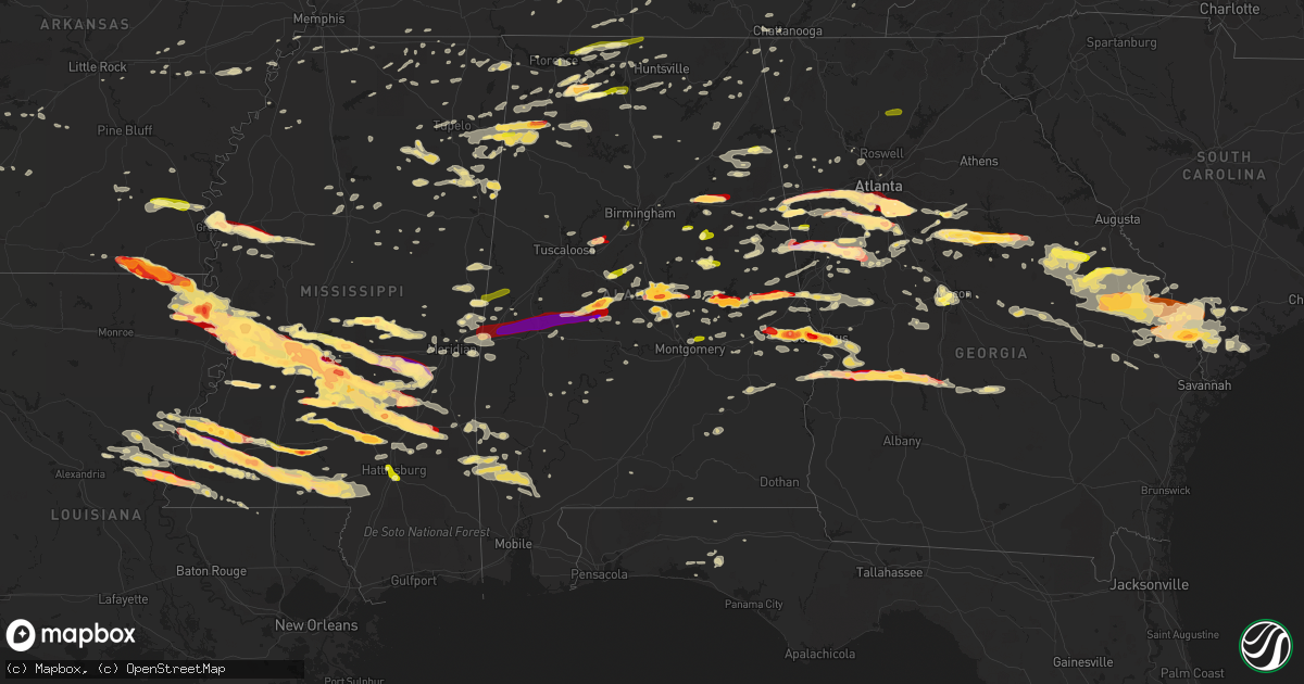
Hail Map in Alabama on March 18, 2013
Get this storm
March 18 map
$229
one time, instant access
Download today. No call, no setup
Keep the $229
Bought the map and want the full workflow? Apply the entire $229 to a subscription within 7 days. None of it is wasted.
Every map, not just this one
This buys you this map. Subscription and you get every map we run, in the markets you choose from a few cities to whole states to nationwide. Plus real-time alerts the moment a storm fires.
Contact data
Name, contact info, occupancy, even credit band for addresses in the footprint. You go from where it hit to who to call.
Become the source they trust
Unlimited branding weather history reports on demand. You already have the documented answer ready for the property owner, and you are the one who showed up with it.
Property data and RoofTrace estimates
Pull up any address you have got, its value and the exact code rules for that jurisdiction, straight from One Click Code. Then RoofTrace estimates the squares, pitch, and roof value, priced the way you price.
Storm reports in Alabama
Alabama
| Date | Description |
|---|---|
| 03/18/20136:17 PM CDT | A local report indicates 1.50 inch wind near 3 NW PHENIX CITY |
| 03/18/20136:17 PM CDT | A local report indicates 1.25 inch wind near PHENIX CITY |
| 03/18/20136:14 PM CDT | Up to 2 inch hail covering the ground. Hail fell for 10 minutes. |
| 03/18/20136:12 PM CDT | Average size of the hail was 1.25 inches...with the largest hail size being 2 inches. The hail completely covered the ground. |
| 03/18/20136:08 PM CDT | A local report indicates 1.75 inch wind near 5 WNW PHENIX CITY |
| 03/18/20135:45 PM CDT | Hail ranged from 0.25 to 1 inch in diameter. |
| 03/18/20135:40 PM CDT | Hail measured and pictured of 2.5 to 3 inches just south of salem in southern lee county. |
| 03/18/20135:30 PM CDT | Several trees were blown door in millbrook. |
| 03/18/20135:25 PM CDT | Hail up to quarters observed. A funnel cloud was also see at state route 51. Winds were 55 to 60 mph...with no damage from the winds. |
| 03/18/20135:13 PM CDT | Reported near still waters resort. Time estimated from radar. |
| 03/18/20135:10 PM CDT | Trees down in new site. Winds measured 49 mph in alex city. |
| 03/18/20135:02 PM CDT | One inch to one and three quarters inch hail reported along interstate 65 between mile markers 193 and 197. |
| 03/18/20135:00 PM CDT | Hail up to the size of golf balls fell for 15 minutes |
| 03/18/20134:59 PM CDT | Quarter sized hail reported at childrens harbor |
| 03/18/20134:58 PM CDT | A local report indicates 1.00 inch wind near 3 ESE NOTASULGA |
| 03/18/20134:57 PM CDT | Quarter sized hail reported at childrens harbor |
| 03/18/20134:55 PM CDT | A local report indicates 1.00 inch wind near 5 SSE YORK |
| 03/18/20134:54 PM CDT | A local report indicates 1.75 inch wind near 6 SW DADEVILLE |
| 03/18/20134:53 PM CDT | A local report indicates 1.00 inch wind near VALLEY |
| 03/18/20134:53 PM CDT | A local report indicates 1.25 inch wind near LANETT |
| 03/18/20134:37 PM CDT | One business lost its roof on 32nd street sw. |
| 03/18/20134:34 PM CDT | One inch hail covering the ground at the rest area along highway 82. |
| 03/18/20134:34 PM CDT | Reported near sprott. Time estimated from radar. |
| 03/18/20134:28 PM CDT | Power lines down |
| 03/18/20134:27 PM CDT | Trees and power lines down. |
| 03/18/20134:22 PM CDT | Hail up to quarters fell as well as several trees blown down...blocking main street and hwy 9. |
| 03/18/20134:22 PM CDT | Trees and power lines down neary hwy 49 and abel rd. |
| 03/18/20134:21 PM CDT | A local report indicates 1.75 inch wind near STURKIE |
| 03/18/20134:16 PM CDT | Quarter size hail fell for 5 minutes during the storm. |
| 03/18/20134:14 PM CDT | Hail lasted for ten minutes with up to quarters observed. |
| 03/18/20134:13 PM CDT | A local report indicates 1.25 inch wind near CAMP HILL |
| 03/18/20134:11 PM CDT | Roof of acker electric co building partially removed. Winds estimated at 70-80 mph by trained nws spotter. |
| 03/18/20134:09 PM CDT | Roof damage to campus inn |
| 03/18/20134:08 PM CDT | Trees down on hwy 35 near dekalb county line |
| 03/18/20134:05 PM CDT | A roof was blown off a residence on mcelderry road and a tree fell on a house facing mitchell street adjacent to munford town hall. |
| 03/18/20134:05 PM CDT | Roof off barn on yancy drive |
| 03/18/20134:05 PM CDT | A few trees reported down along cr 10...one blocking a portion of the road. Time estimated from radar. |
| 03/18/20134:05 PM CDT | Trees and power lines down here and in munford on priebes road and grant town road. |
| 03/18/20134:03 PM CDT | Three of four trees were down on houses and several roads blocked. Cherry street...taylors mill road... Mountain view road...and east street south were are blocked or p |
| 03/18/20134:03 PM CDT | The roof of the library at jacksonville state was partially removed. The transmitter for the radio station on the roof was destroyed. |
| 03/18/20134:00 PM CDT | Tree down on a house on cr 479 near kilpatrick. |
| 03/18/20134:00 PM CDT | Anemometer registered 88 mph prior to losing a cup. Numerous trees and powerlines down. |
| 03/18/20134:00 PM CDT | Three of four trees were sown on houses and several roads blocked. Cherry street...taylors mill road... Mountain view road...and east street south were are blocked or p |
| 03/18/20133:57 PM CDT | Exit 212 on i65 |
| 03/18/20133:57 PM CDT | Trees on house. Residents trapped. |
| 03/18/20133:56 PM CDT | Tree on house on silverwood drive with entrapment |
| 03/18/20133:56 PM CDT | At least quarter size hail near centreville. Time estimated from radar. |
| 03/18/20133:56 PM CDT | Large tree uprooted. |
| 03/18/20133:55 PM CDT | Quarter sized hail reported in skirum |
| 03/18/20133:55 PM CDT | Roof damage to collinsville high school gym and roof damage to national guard armory. |
| 03/18/20133:55 PM CDT | Outbuilding destroyed near county schools coliseum east of rainsville |
| 03/18/20133:55 PM CDT | A local report indicates 2.00 inch wind near LINCOLN |
| 03/18/20133:55 PM CDT | Power lines and trees down in skirum |
| 03/18/20133:54 PM CDT | Spotter reports power poles snapped and at least one barn destroyed at this location west of rainsville. |
| 03/18/20133:54 PM CDT | Spotter reported gutters and signs blown down between rainsville and fyffe. Numerous trees down including cedar trees. Roof off a barn. Roof damage to a house on jolley |
| 03/18/20133:54 PM CDT | Spotter reports several roads blocked due to downed trees. Chicken houses heavily damaged on cr50. Trees snapped and power lines down on cr 50. |
| 03/18/20133:53 PM CDT | A local report indicates 1.00 inch wind near ODENVILLE |
| 03/18/20133:53 PM CDT | Chicken house roof blown off and trees down |
| 03/18/20133:52 PM CDT | Part of roof blown off of a church on county rd 16 |
| 03/18/20133:52 PM CDT | Approximately 20 trees down on al hwy 77 |
| 03/18/20133:52 PM CDT | A mobile home was blown off of the foundation on county rd 162. Time estimated from radar. |
| 03/18/20133:52 PM CDT | Structural damage to a house on county road 406 near dutton. |
| 03/18/20133:51 PM CDT | An ef2 tornado touched down along cr 539 north of cr 50 in dekalb county in the fyffe and shiloh communities. The most significant damage with this tornado occurred alo |
| 03/18/20133:51 PM CDT | At least 3 inch hail reported at the state eoc. |
| 03/18/20133:51 PM CDT | Numerous trees were down and damage to one residence. |
| 03/18/20133:50 PM CDT | Tree on house on rainbow drive with entrapment |
| 03/18/20133:50 PM CDT | Just south of exit 212 on i65. Corrected for location and time. |
| 03/18/20133:48 PM CDT | Hail observed between 2.25 and 2.5 inches in diameter near the walmart in clanton. |
| 03/18/20133:46 PM CDT | An airport hanger door was blown in and damaged an airplane at the st clair county airport |
| 03/18/20133:46 PM CDT | Golf ball size hail was reported on depot street...as well as trees down. Some were snapped others uprooted...but all were facing the same direction. |
| 03/18/20133:46 PM CDT | Multiple trees down stouts road elkwood rd |
| 03/18/20133:46 PM CDT | Trees down cr41 and walnut grove rd. Trailer blown over on walnut grove rd. Correction. Well house blown onto trailer |
| 03/18/20133:45 PM CDT | 3 or 4 trailers were damaged at al hwy 68 and al 168 |
| 03/18/20133:45 PM CDT | According to pell city schools...duran jr high school sustained roof damage. The roof of the press box at the football field was also damaged. |
| 03/18/20133:43 PM CDT | *** 3 inj *** an ef1 tornado with winds of 95-105 mph touched down in marshall county and moved eastward into north etowah county. The tornado downed hundreds of trees. |
| 03/18/20133:42 PM CDT | Trees down and houses damaged in a 5 by 8 block in boaz near hwy 205 |
| 03/18/20133:41 PM CDT | *** 3 inj *** the tornado initially touched down just east of u.s. Hwy 431 in boaz just south of bruce road with some minor structural damage to businesses along hwy 43 |
| 03/18/20133:41 PM CDT | *** 7 inj *** an ef2 tornado touched down on hambey road just east of mcville road in marshall county and tracked east into dekalb county. The most significant tornado |
| 03/18/20133:41 PM CDT | Metal roofing was removed from a chicken house along highway 132. Winds est at 80 mph. |
| 03/18/20133:41 PM CDT | A dozen trees were uprooted and metal roofing was removed from a portion of a home along highway 132. Winds est at 80 mph. |
| 03/18/20133:40 PM CDT | 3 buildings damaged including a roof blown off. A road was blocked due to this damage. |
| 03/18/20133:40 PM CDT | Several pine trees were snapped and a mobile home overturned. Winds est at 70 mph. |
| 03/18/20133:39 PM CDT | A wind damage swath 600 yds long and 150 yds wide downed approx 4 dozen trees along the northwest shore of doctor jenkins lake. Winds est at 85 mph. |
| 03/18/20133:37 PM CDT | Damage to 3 structures on hwy 431 and rose road. Extent of damage unknown at this time. |
| 03/18/20133:35 PM CDT | Downed trees across the county. Alabama hwy 171 was blocked for 30 minutes due to trees down. |
| 03/18/20133:35 PM CDT | Via emergency management |
| 03/18/20133:34 PM CDT | Numerous trees down in the 1600 block of park avenue and acton road. |
| 03/18/20133:33 PM CDT | Couple pine trees snapped and powerlines down along ridgewood drive. Time estimated from radar. |
| 03/18/20133:32 PM CDT | Several trees were down across the area. |
| 03/18/20133:30 PM CDT | Trees on hour 2184 self creek rd center point. Additional trees clayton rd and old springville rd in clay. |
| 03/18/20133:30 PM CDT | Some trees fell in argo across us 11. |
| 03/18/20133:30 PM CDT | Numerous trees down. Wind gusts in excess of 55 mph reported. |
| 03/18/20133:30 PM CDT | Numerous trees down. Estimated wind gusts in excess of 55 mph. |
| 03/18/20133:29 PM CDT | Roof damage to home |
| 03/18/20133:28 PM CDT | Reported near abernant. Time estimated from radar. |
| 03/18/20133:28 PM CDT | Structural damage to a business in town |
| 03/18/20133:28 PM CDT | Trees down and shingles off roof |
| 03/18/20133:27 PM CDT | Large tree down with roof damage on several homes. Power lines down as well. |
| 03/18/20133:24 PM CDT | On hwy 79 at mile marker 118...trees blocking all lanes of highway. |
| 03/18/20133:23 PM CDT | A tree was uprooted in front of moore hall near the quad. |
| 03/18/20133:22 PM CDT | Trees down in town |
| 03/18/20133:22 PM CDT | Trees down around bill jones road. Tin roof was blown off a vacant manufactured home just off old sardis road. |
| 03/18/20133:20 PM CDT | Trees and power lines down |
| 03/18/20133:20 PM CDT | Taylors ferry and warrior river rd at union hill church |
| 03/18/20133:20 PM CDT | Quarter sized hail reported. |
| 03/18/20133:18 PM CDT | Trees down on cr 47 near the cullman county line. |
| 03/18/20133:17 PM CDT | Multiple trees down near stouts road and elkwood rd. |
| 03/18/20133:16 PM CDT | Trees down on hwy 160 near cr 13 |
| 03/18/20133:14 PM CDT | Trees down on hwy 91 |
| 03/18/20133:12 PM CDT | Dozen pine trees down in town. |
| 03/18/20133:10 PM CDT | Dozen large pine trees down pointing in a uniform direction. |
| 03/18/20133:10 PM CDT | Roof damage to a mobile home on shaw road. |
| 03/18/20133:09 PM CDT | Multiple trees down on cr 747 between hwy 91 and cr 703 |
| 03/18/20133:09 PM CDT | Power lines down near crosshaven church on hwy 31 |
| 03/18/20133:07 PM CDT | 2 large trees damaged. Time estimated from radar. |
| 03/18/20133:06 PM CDT | Trees blown down. |
| 03/18/20133:06 PM CDT | Trees down on mt. View road. |
| 03/18/20133:05 PM CDT | Trees down on a mobile home. Cr265 in town creek. |
| 03/18/20132:46 PM CDT | Trees down with roads blocked in numerous locations. 2 manufactured homes overturned in dogwood acres. |
| 03/18/20132:46 PM CDT | Trees and power lines down |
| 03/18/20132:41 PM CDT | Numerous trees blown down blocking highway 33. |
| 03/18/20132:36 PM CDT | Several large trees snapped along al hwy 5 near the lupton school...with trees down and blocking prospect road near hwy 5 and damaging a house. |
| 03/18/20132:36 PM CDT | Wood storage building and two car metal garage destroyed at the intersection of cr 244/157. |
| 03/18/20132:35 PM CDT | Measured 63 mph wind gust at courtland airport /awos/. |
| 03/18/20132:35 PM CDT | Six large wooden power poles snapped/knocked down. |
| 03/18/20132:27 PM CDT | Tree across road with phone and power lines down at the road intersection of oakmont trail and log cabin trail. |
| 03/18/20132:27 PM CDT | Trees down and transformers blown in town. |
| 03/18/20132:26 PM CDT | Trees down across hwy 171 near the intersection of hwy 159 on the south end of town. |
| 03/18/20132:26 PM CDT | Multiple trees blown down and blocking hatton school road. |
| 03/18/20132:25 PM CDT | Trees down in town |
| 03/18/20132:25 PM CDT | Quarter sized hail reported by fire department. Winds reported to 40 mph. |
| 03/18/20132:24 PM CDT | Trees and power lines down |
| 03/18/20132:20 PM CDT | A portable garage blown up into a tree on foster mill road. |
| 03/18/20132:20 PM CDT | Trees blown down and blocking the road. Intersection of cr 70/570. |
| 03/18/20132:20 PM CDT | Trees and power lines down. |
| 03/18/20132:18 PM CDT | Quarter sized hail near the intersection of hwy 99 and tillman mill. |
| 03/18/20132:18 PM CDT | Trees and power lines down throughout town. Some building damage but unknown quantity at this time. |
| 03/18/20132:15 PM CDT | Trees blown down and minor roof damage to several small buildings in the bear creek area. |
| 03/18/20132:13 PM CDT | At the eoc |
| 03/18/20132:12 PM CDT | Quarter size hail was reported. |
| 03/18/20132:11 PM CDT | Tree down on a structure on college avenue. |
| 03/18/20132:10 PM CDT | Quarter sized hail at 4th and 11th in decatur. |
| 03/18/20132:10 PM CDT | Dozen large pine trees down pointing in a uniform direction. |
| 03/18/20132:09 PM CDT | Trees and power lines down |
| 03/18/20132:08 PM CDT | Trees down on house. |
| 03/18/20132:06 PM CDT | Tree down blocking the road near the sheffield city hall. |
| 03/18/20132:04 PM CDT | *** 1 inj *** estimated winds of 50-60 mph. Numerous powerlines and trees down in town. Several homes damaged. Two destroyed. One tree landed on a car and trapped an in |
| 03/18/20132:02 PM CDT | Trees and power line down |
| 03/18/20131:55 PM CDT | A local report indicates 1.75 inch wind near BEXAR |
| 03/18/20131:50 PM CDT | Quarter size hail reported at the intersection of al hwy 24 and county road 434 northeast of moulton. |
| 03/18/20131:48 PM CDT | Electrical lines down on residence near barton. Time estimated from radar. |
| 03/18/20131:47 PM CDT | Structural damage reported by emergency management along highway 190. Time estimated from radar. |
| 03/18/20131:46 PM CDT | Quarter sized hail reported in downtown moulton. |
| 03/18/20131:45 PM CDT | Trees and powerlines down around red bay. Along highway 19 and 11 north and south of town. Time estimated from radar. |
| 03/18/20131:40 PM CDT | Tree down across road at allsboro...5 miles south of hwy 72. Time estimated from radar. |
| 03/18/20131:38 PM CDT | A local report indicates 1.75 inch wind near HACKLEBURG |
| 03/18/20131:25 PM CDT | At the intersection of cr 20 and 25. |
| 03/18/20131:18 PM CDT | Silver dollar sized hail reported in hatton |
| 03/17/20137:21 PM CDT | Significant portion of metal roof removed from a residence along cr 20. Time estimated from radar. |
All States Impacted by Hail Map on March 18, 2013
Cities Impacted by Hail Map on March 18, 2013
- Russellville, AL
- Moulton, AL
- Courtland, AL
- Town Creek, AL
- Mount Hope, AL
- Piedmont, AL
- Jacksonville, AL
- Clanton, AL
- Verbena, AL
- Aberdeen, MS
- Raleigh, MS
- Flora, MS
- Okatie, SC
- Ridgeland, SC
- Montgomery, AL
- Millbrook, AL
- Calera, AL
- Clayton, LA
- Ferriday, LA
- Bogue Chitto, MS
- Ruth, MS
- Smithdale, MS
- Summit, MS
- Natchez, MS
- Sicily Island, LA
- Lumberton, MS
- Bude, MS
- McCall Creek, MS
- Foxworth, MS
- Meadville, MS
- Kokomo, MS
- Columbia, MS
- Mccomb, MS
- Liberty, MS
- Roxie, MS
- Tylertown, MS
- Jayess, MS
- Sandy Hook, MS
- Starkville, MS
- Fayette, MS
- Carrollton, GA
- Carlisle, AR
- Senoia, GA
- Fayetteville, GA
- Richland, MS
- Transylvania, LA
- Lake Providence, LA
- Harvest, AL
- Corinth, MS
- Redwood, MS
- De Kalb, MS
- Daleville, MS
- Rome, GA
- Cedar Bluff, AL
- Newington, GA
- Goodwater, AL
- Prentiss, MS
- Newhebron, MS
- Rocky Face, GA
- Waynesboro, MS
- Swainsboro, GA
- Dublin, GA
- Wrightsville, GA
- Kite, GA
- Tennille, GA
- Adrian, GA
- Toomsboro, GA
- East Dublin, GA
- Irwinton, GA
- Collinsville, MS
- Meridian, MS
- Strong, AR
- Muscle Shoals, AL
- Varnville, SC
- Opelika, AL
- Holly Springs, MS
- Marion, MS
- Laurel, MS
- Bay Springs, MS
- Stringer, MS
- Waynesboro, GA
- State Line, MS
- Prattville, AL
- Marbury, AL
- Monterey, LA
- Rainsville, AL
- Fyffe, AL
- Belzoni, MS
- Athens, AL
- Toney, AL
- Hogansville, GA
- Collins, MS
- Mount Olive, MS
- Seminary, MS
- Monticello, MS
- Pinola, MS
- Ranburne, AL
- Bowdon, GA
- Luthersville, GA
- Greenville, MS
- Kentwood, LA
- Tallapoosa, GA
- Bremen, GA
- Lagrange, GA
- Greenville, GA
- Olive Branch, MS
- Byhalia, MS
- Wilmot, AR
- Jones, LA
- Hamburg, AR
- Newton, MS
- Rose Hill, MS
- Louin, MS
- Pearl, MS
- Jackson, MS
- Flowood, MS
- Cornersville, TN
- Petersburg, TN
- Moreland, GA
- Newnan, GA
- Sharpsburg, GA
- McIntosh, AL
- Harrisville, MS
- Porterville, MS
- Scooba, MS
- Beaufort, SC
- Pell City, AL
- Anniston, AL
- Lincoln, AL
- Riverside, AL
- Eastaboga, AL
- Ragland, AL
- Greensboro, AL
- Newbern, AL
- Marion, AL
- Centreville, AL
- Lawley, AL
- Temple, GA
- Villa Rica, GA
- Waco, GA
- Winston, GA
- Raymond, MS
- Terry, MS
- Byram, MS
- Grantville, GA
- Pisgah, AL
- Henagar, AL
- Deatsville, AL
- Billingsley, AL
- Fort Valley, GA
- Mendenhall, MS
- Braxton, MS
- Clinton, MS
- Hazlehurst, MS
- Georgetown, MS
- Tunica, MS
- Buckatunna, MS
- Silas, AL
- Frankville, AL
- Millry, AL
- Forest, MS
- Decatur, MS
- Walnut Grove, MS
- Union, MS
- Carthage, MS
- Sebastopol, MS
- Philadelphia, MS
- Lena, MS
- Conehatta, MS
- Gay, GA
- Paulding, MS
- Hickory, MS
- Morton, MS
- Pachuta, MS
- Madison, MS
- Lake, MS
- Lawrence, MS
- Canton, MS
- Pulaski, MS
- Brandon, MS
- Ridgeland, MS
- Pelahatchie, MS
- Richland, GA
- Buena Vista, GA
- Cusseta, GA
- Americus, GA
- Plains, GA
- Bartow, GA
- Oak Grove, LA
- Soso, MS
- Douglasville, GA
- Hampton, GA
- Valley Park, MS
- Tyrone, GA
- Jonesboro, GA
- Peachtree City, GA
- Metter, GA
- Greensburg, LA
- Covington, GA
- Mansfield, GA
- Deer Park, AL
- Fruitdale, AL
- Vinegar Bend, AL
- Tibbie, AL
- Walnut, MS
- Houlka, MS
- Vardaman, MS
- Alpine, AL
- Pioneer, LA
- Vidalia, LA
- Jonesville, LA
- Amory, MS
- Fulton, MS
- Trinity, AL
- Abbeville, MS
- Brookhaven, MS
- Alexander City, AL
- Dadeville, AL
- Epps, LA
- Davisboro, GA
- Louisville, GA
- Edwards, MS
- Acme, LA
- Woodville, MS
- Inverness, MS
- Indianola, MS
- Vicksburg, MS
- Magee, MS
- Florence, MS
- Bolton, MS
- Heidelberg, MS
- Woodland, MS
- Stockbridge, GA
- Rex, GA
- Columbus, GA
- Garnett, SC
- Pineland, SC
- Sardis, GA
- Millen, GA
- Sylvania, GA
- Statesboro, GA
- Yemassee, SC
- Wadley, GA
- Midville, GA
- Early Branch, SC
- Garfield, GA
- Twin City, GA
- Clyo, GA
- Tillman, SC
- Estill, SC
- Guyton, GA
- Springfield, GA
- Rocky Ford, GA
- Hardeeville, SC
- Greenwood Springs, MS
- Crosby, MS
- Des Arc, AR
- Weir, MS
- McCool, MS
- Satartia, MS
- Lisman, AL
- Wesson, MS
- Leland, MS
- Isola, MS
- Hollandale, MS
- Hillsboro, AL
- Talladega, AL
- Auburn, AL
- Phenix City, AL
- Fort Benning, GA
- Salem, AL
- Smiths Station, AL
- Tremont, MS
- Hamilton, AL
- Wellington, AL
- Hamilton, GA
- Lester, AL
- Elkmont, AL
- Eatonton, GA
- Randolph, AL
- Mcdonough, GA
- Ellenwood, GA
- Morrow, GA
- Forest Park, GA
- Warthen, GA
- Gibson, GA
- Mitchell, GA
- Avera, GA
- Stapleton, GA
- Wrens, GA
- Brooks, GA
- Malvern, AR
- Silver Creek, MS
- Union Church, MS
- Oak Vale, MS
- Waterproof, LA
- McGehee, AR
- Rohwer, AR
- Monticello, AR
- Dermott, AR
- Arkansas City, AR
- Palmetto, GA
- Whitesburg, GA
- Locust Grove, GA
- Griffin, GA
- Rhine, GA
- Eastman, GA
- Abbeville, GA
- Pitts, GA
- Rochelle, GA
- Cedartown, GA
- Macon, GA
- Sawyerville, AL
- Vienna, GA
- Lauderdale, MS
- Plantersville, AL
- Jones, AL
- Toomsuba, MS
- York, AL
- Cuba, AL
- Detroit, AL
- Marianna, AR
- Gloster, MS
- Georgetown, TN
- Riceville, TN
- Caledonia, MS
- Houston, MS
- Mount Vernon, AL
- Eufaula, AL
- Pittsview, AL
- Omaha, GA
- Falkville, AL
- Somerville, AL
- Hartselle, AL
- Whiteside, TN
- Chattanooga, TN
- Cottondale, AL
- Brookwood, AL
- Vance, AL
- Port Gibson, MS
- Livingston, AL
- Sparta, GA
- Monticello, GA
- Holladay, TN
- Holcomb, MS
- Grenada, MS
- Rogersville, AL
- Anderson, AL
- Thorsby, AL
- Centreville, MS
- Valley, AL
- West Point, GA
- Rison, AR
- Red Bay, AL
- Dutton, AL
- Scottsboro, AL
- Bryant, AL
- Okolona, MS
- Hillsboro, GA
- Franklin, GA
- Roanoke, AL
- Lineville, AL
- Potts Camp, MS
- Lake Village, AR
- Williamson, GA
- Shady Dale, GA
- Jackson, GA
- Flovilla, GA
- Lake Cormorant, MS
- Nesbit, MS
- Aliceville, AL
- Macon, MS
- Daviston, AL
- Hughes, AR
- Hazen, AR
- Smithville, MS
- Baldwyn, MS
- Booneville, MS
- Shannon, MS
- Wadley, AL
- Cragford, AL
- Mayersville, MS
- Brooklet, GA
- Guin, AL
- Rockmart, GA
- Eclectic, AL
- Mize, MS
- Bentonia, MS
- Prairie, MS
- Hackleburg, AL
- Hodges, AL
- Vina, AL
- Phil Campbell, AL
- Madison, AL
- Huntsville, AL
- Port Royal, SC
- Duck Hill, MS
- Ovett, MS
- Marks, MS
- Pickens, AR
- Dumas, AR
- Concord, GA
- Red Banks, MS
- Haleyville, AL
- Waverly, AL
- Lafayette, AL
- Equality, AL
- Camp Hill, AL
- Hamilton, MS
- Sulligent, AL
- Sylacauga, AL
- Guild, TN
- Jasper, TN
- Woodville, AL
- New Hope, AL
- Red Oak, GA
- Union City, GA
- Fairburn, GA
- Conley, GA
- Atlanta, GA
- Barnesville, GA
- Forsyth, GA
- Flat Rock, AL
- Crossett, AR
- Bonita, LA
- Calhoun, TN
- Delano, TN
- Rienzi, MS
- Milner, GA
- Maplesville, AL
- Union Springs, AL
- Banks, AL
- Shorter, AL
- Hardaway, AL
- Sturgis, MS
- Vernon, AL
- Taylorsville, MS
- Lizella, GA
- Preston, GA
- Andersonville, GA
- Ellaville, GA
- Byromville, GA
- Gurley, AL
- Chatom, AL
- Pontotoc, MS
- Tallassee, AL
- Steele, AL
- Shuqualak, MS
- Middleton, TN
- Ohatchee, AL
- Freeport, FL
- Sondheimer, LA
- West Blocton, AL
- Rockford, AL
- Jemison, AL
- Cherokee, AL
- Tuscumbia, AL
- Midway, AL
- Falkner, MS
- Tiplersville, MS
- Rolling Fork, MS
- Rutledge, GA
- Riverdale, GA
- Cullman, AL
- Holly Pond, AL
- Gadsden, AL
- Centre, AL
- Hatchechubbee, AL
- Seale, AL
- Florala, AL
- Crossville, AL
- Boaz, AL
- Albertville, AL
- Camden, AL
- Hernando, MS
- Robinsonville, MS
- Utica, MS
- Pine Hill, AL
- Cedarbluff, MS
- Ellisville, MS
- Dallas, GA
- Athens, TN
- Woodland, GA
- Newborn, GA
- Coy, AL
- Sandersville, GA
- Keysville, GA
- Delta, AL
- Woodland, AL
- Wedowee, AL
- Hattiesburg, MS
- Hermanville, MS
- Chickamauga, GA
- Minter, AL
- Tuskegee, AL
- Five Points, AL
- Lanett, AL
- Cusseta, AL
- Stewart, MS
- French Camp, MS
- Warren, AR
- Wilmar, AR
- New Edinburg, AR
- Acworth, GA
- Ripley, MS
- McCalla, AL
- Bastrop, LA
- Crystal Springs, MS
- Spruce Pine, AL
- Ponce De Leon, FL
- Winona, MS
- De Valls Bluff, AR
- Clarendon, AR
- Randolph, MS
- Valhermoso Springs, AL
- Little Rock, MS
- Munford, AL
- Wetumpka, AL
- Heflin, AL
- Carrollton, MS
- McCarley, MS
- Leighton, AL
- Stockton, AL
- Wagarville, AL
- Jackson, AL
- Claxton, GA
- Register, GA
- Cobbtown, GA
- Dumas, MS
- Menlo, GA
- Valley Head, AL
- Rising Fawn, GA
- Meridianville, AL
- Selma, AL
- Whitwell, TN
- Talbotton, GA
- Lookout Mountain, GA
- Trenton, GA
- Wildwood, GA
- Troy, AL
- Glenwood, AL
- Ashland, MS
- Tuscaloosa, AL
- Tishomingo, MS
- Iuka, MS
- Florence, AL
- Guntown, MS
- Blue Springs, MS
- Saltillo, MS
- Little Rock, AR
- Darden, TN
- Lexington, TN
- Scott, AR
- Richton, MS
- Emelle, AL
- Weogufka, AL
- Water Valley, MS
- Santa Rosa Beach, FL
- Bessemer, AL
- Birmingham, AL
- Jenkinsburg, GA
- Columbus, MS
- Burnsville, MS
- Bismarck, AR
- Beaverton, AL
- Nettleton, MS
- Bear Creek, AL
- Myrtle, MS
- Gordon, GA
- Jeffersonville, GA
- Notasulga, AL
- Houston, AL
- Double Springs, AL
- Kennesaw, GA
- Zebulon, GA
- Hanceville, AL
- Bremen, AL
- Hayden, AL
- Belden, MS
- Tupelo, MS
- Laceys Spring, AL
- Decatur, AL
- Louisville, MS
- Milledgeville, GA
- Dry Branch, GA
- Gilbertown, AL
- Itta Bena, MS
- Marksville, LA
- Effie, LA
- Chunky, MS
- West Point, MS
- Steens, MS
- Whiteville, TN
- Ackerman, MS
- Aubrey, AR
- Moro, AR
- Pulaski, TN
- Langston, AL
- Jena, LA
- Green Pond, SC
- Mantachie, MS
- Madison, GA
- Milan, GA
- Cruger, MS
- Coahoma, MS
- Graham, AL
- Lawrenceburg, TN
- Titus, AL
- Grand Junction, TN
- Saulsbury, TN
- Ethel, MS
- Plantersville, MS
- Lumpkin, GA
- Donaldson, AR
- Culloden, GA
- Eupora, MS
- Pine Mountain, GA
- Shiloh, GA
- Pine Mountain Valley, GA
- Conyers, GA
- Matthews, GA
- Marietta, GA
- Golden, MS
- Waynesboro, TN
- Waverly Hall, GA
- Cataula, GA
- Jacksons Gap, AL
- Kellyton, AL
- Altoona, AL
- Tanner, AL
- Boligee, AL
- Bonifay, FL
- Caryville, FL
- Defuniak Springs, FL
- Summerville, GA
- Owens Cross Roads, AL
- Senatobia, MS
- Shelby, AL
- Enterprise, MS
- Vossburg, MS
- Shubuta, MS
- Tallulah, LA
- Tougaloo, MS
- Leola, AR
- Deville, LA
- Hickory Flat, MS
- Castleberry, AL
- Evergreen, AL
- Ashland, AL
- Dundee, MS
- Northport, AL
- Roberta, GA
- Knoxville, GA
- Musella, GA
- West, MS
- Faunsdale, AL
- Moselle, MS
- Westville, FL
- Roopville, GA
- Frankewing, TN
- Allendale, SC
- Fairfax, SC
- Pembroke, GA
- Collinwood, TN
- Cordele, GA
- Gurdon, AR
- Trussville, AL
- Box Springs, GA
- Saint Stephens, AL
- Thomasville, AL
- Glen, MS
- Sardis, AL
- Brent, AL
- Ward, AL
- Prospect, TN
- Goodspring, TN
- Leoma, TN
- Epes, AL
- Brierfield, AL
- Montevallo, AL
- Quitman, MS
- Niceville, FL
- Gallion, AL
- Reynolds, GA
- Muscadine, AL
- Lexington, AL
- Killen, AL
- Little River, AL
- Blythe, GA
- Brooksville, MS
- Lynn, AL
- Prescott, AR
- Yatesville, GA
- Ardmore, AL
- Tillar, AR
- Forkland, AL
- Demopolis, AL
- Dawsonville, GA
- Ball Ground, GA
- Gainesville, AL


