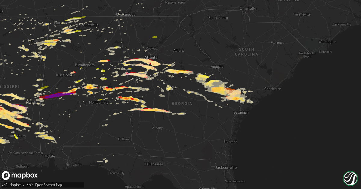
Hail Map in Georgia on March 18, 2013
Get this storm
March 18 map
$229
one time, instant access
Download today. No call, no setup
Keep the $229
Bought the map and want the full workflow? Apply the entire $229 to a subscription within 7 days. None of it is wasted.
Every map, not just this one
This buys you this map. Subscription and you get every map we run, in the markets you choose from a few cities to whole states to nationwide. Plus real-time alerts the moment a storm fires.
Contact data
Name, contact info, occupancy, even credit band for addresses in the footprint. You go from where it hit to who to call.
Become the source they trust
Unlimited branding weather history reports on demand. You already have the documented answer ready for the property owner, and you are the one who showed up with it.
Property data and RoofTrace estimates
Pull up any address you have got, its value and the exact code rules for that jurisdiction, straight from One Click Code. Then RoofTrace estimates the squares, pitch, and roof value, priced the way you price.
Storm reports in Georgia
Georgia
| Date | Description |
|---|---|
| 03/18/20136:54 PM CDT | Tree down on a mobile home nerar byron. |
| 03/18/20136:45 PM CDT | Numerous trees down across county. |
| 03/18/20136:42 PM CDT | Kmcn asos measured 52kt gust. |
| 03/18/20136:40 PM CDT | Numerous trees and powerlines down across the city. Several trees are on homes with people trapped. |
| 03/18/20136:37 PM CDT | Numerous trees and powerlines down in lake wildwood subdivision...1 mile west of i475. Media also reported the press box at the first presbyterian day school on calvin |
| 03/18/20136:36 PM CDT | The fort benning emergency manager estimated wind gusts to 60 mph that caused damage to several trees on this portion of the military reservation. Dime-sized hail was a |
| 03/18/20136:36 PM CDT | The fort benning emergency manager estimated wind gusts to 60 mph that caused damage to several trees on this portion of the military reservation. Dime-sized hail was a |
| 03/18/20136:30 PM CDT | Numerous trees down across county. |
| 03/18/20136:20 PM CDT | Monroe county em relayed a report trees down countywide along with a car accident caused by the weather. |
| 03/18/20136:15 PM CDT | Golfball sized hail reported in the mansfield area. |
| 03/18/20136:15 PM CDT | A local report indicates 1.00 inch wind near COLUMBUS |
| 03/18/20136:15 PM CDT | Public reported golf ball sized hail north of americus. |
| 03/18/20136:14 PM CDT | Up to 2 inch hail covering the ground. Hail fell for 10 minutes. |
| 03/18/20136:11 PM CDT | A local report indicates 1.00 inch wind near 2 N AMERICUS |
| 03/18/20136:10 PM CDT | Public reported the size of golfball sized hail in eatonton. The hail was so deep it covered the ground completly. |
| 03/18/20136:08 PM CDT | Public reported golfball sized hail damaged a windshield of a car on u.s. Highway 19 northwest of americus. |
| 03/18/20136:00 PM CDT | Trees and powerlines were blown down countywide...particularly in the yatesville area. |
| 03/18/20135:59 PM CDT | Butts county em relayed a report of trees down countywide along with numerous powerlines down. Tree damage was especially heavy near flovilla. |
| 03/18/20135:55 PM CDT | Lasted 20 minutes...hail up to golfball sized hail. |
| 03/18/20135:50 PM CDT | A local report indicates 1.75 inch wind near MCDONOUGH |
| 03/18/20135:50 PM CDT | *** 1 fatal *** several trees were blown down near georgia highway 36. At least one tree blocked a portion of the highway. A motorist swerved to avoid the tree and lost |
| 03/18/20135:49 PM CDT | Numerous trees down throughout harris county. |
| 03/18/20135:45 PM CDT | Widespread dime-sized hail covered the ground along georgia highway 30 with some of the hailstones as large as golfballs. |
| 03/18/20135:40 PM CDT | Reported by former nws employee |
| 03/18/20135:40 PM CDT | Hail ranging from one to two inches reported in southern clayton county. |
| 03/18/20135:39 PM CDT | Quarter sized hail reported in hampton. |
| 03/18/20135:31 PM CDT | Pike county emergency manager and broadcast media reported damage on caldwell bridge road. A home sustained minor roof damage...had both doors blown out...and four fron |
| 03/18/20135:30 PM CDT | The public relayed a report of baseball sized hail in stockbridge. |
| 03/18/20135:30 PM CDT | Tennis ball sized hail reported in fayetteville. |
| 03/18/20135:25 PM CDT | Along mask road fayetteville. |
| 03/18/20135:25 PM CDT | Numerous trees were blown down on elders mill road. |
| 03/18/20135:25 PM CDT | A local report indicates 1.00 inch wind near DAWSONVILLE |
| 03/18/20135:25 PM CDT | A nws survey team determined an ef-2 tornado touched down in meriwether county and moved into pike county. A home sustained minor roof damage...had both doors blown out |
| 03/18/20135:25 PM CDT | A local report indicates 1.00 inch wind near FAYETTEVILLE |
| 03/18/20135:15 PM CDT | Baseball sized hail reported in stockbridge. |
| 03/18/20135:13 PM CDT | A local report indicates 1.50 inch wind near 2 N STOCKBRIDGE |
| 03/18/20135:12 PM CDT | Numerous reports of damage from hail in luthersville |
| 03/18/20135:12 PM CDT | A few trees were blown down or snapped in the woodstock area. |
| 03/18/20135:10 PM CDT | Coweta county em relayed a report of trees down all across the county. |
| 03/18/20135:10 PM CDT | A nws employee in the summer grove subdivision estimated a wind gust to 60 mph. |
| 03/18/20135:10 PM CDT | An ef2 tornado with wind speeds up to 120 mph touched down near rocky mount road and caldwell road in meriwether county. It traveled east to southeast before lifting on |
| 03/18/20135:10 PM CDT | Coweta county em relayed a report of trees down all across the county. |
| 03/18/20135:10 PM CDT | Harris county 911 relayed a report of numerous trees down near whitesville. |
| 03/18/20135:04 PM CDT | Golfball sized-hail occurred and numerous trees and power lines were blown down in the lithia springs area. Three vehicles were damaged by hail and three were damaged b |
| 03/18/20134:55 PM CDT | A local report indicates 1.00 inch wind near UNION CITY |
| 03/18/20134:55 PM CDT | Golf ball sized hail was reported in grantville. |
| 03/18/20134:50 PM CDT | Golf ball sized hail was reported in grantville. |
| 03/18/20134:49 PM CDT | Public reported roof was blown off of an auto sales store. |
| 03/18/20134:44 PM CDT | Several trees down in cave spring area. Powerlines down on vehicle on padlock mountain road. |
| 03/18/20134:40 PM CDT | A tree was blown down on a house on 2nd st and terrace avenue. |
| 03/18/20134:40 PM CDT | House was destroyed on center road. |
| 03/18/20134:40 PM CDT | *** 7 inj *** nws storm survey team determined that straight-line winds between 80 and 100 mph occurred in the silver creek area. A home off of center road was damaged |
| 03/18/20134:30 PM CDT | Numerous trees blown down or snapped with power outages. |
| 03/18/20134:30 PM CDT | Numerous trees blown down and snapped with power outages in the rome area. |
| 03/18/20134:28 PM CDT | A local report indicates 1.75 inch wind near DOUGLASVILLE |
| 03/18/20134:26 PM CDT | A local report indicates 1.00 inch wind near 2 ESE WARESVILLE |
| 03/18/20134:25 PM CDT | *** 1 fatal *** numerous reports of blown down or snapped trees with power outages in the cedartown area. One tree fell on a car...fatally injuring the occupant who lat |
| 03/18/20134:18 PM CDT | Numerous trees blown down or snapped causing power outages. Some of the trees have fallen on a few homes. |
| 03/18/20134:15 PM CDT | Quarter to half dollar hail reported by public on bell road in bremen. |
| 03/18/20134:07 PM CDT | Numerous hail stones covering the ground were reported near bowden with the largest up to two inches in diameter. |
| 03/18/20134:00 PM CDT | A local report indicates 1.00 inch wind near FORT OGLETHORPE |
| 03/18/20133:50 PM CDT | One inch hail was reported near sand hill elementary school. |
| 03/18/20133:45 PM CDT | Quarter to half dollar sized hail covered the ground. |
| 03/17/20139:45 PM CDT | A local report indicates 1.00 inch wind near BLOOMINGDALE |
| 03/17/20139:20 PM CDT | Dispatch reported a tree down on mark mobly road. Time of event estimated by radar. |
| 03/17/20139:12 PM CDT | A local report indicates 1.75 inch wind near 3 SSW CLYO |
| 03/17/20139:12 PM CDT | A local report indicates 70 MPH wind near 3 SSW CLYO |
| 03/17/20139:10 PM CDT | A local report indicates 1.25 inch wind near CLYO |
| 03/17/20138:54 PM CDT | Tree down at highway 17 near egypt |
| 03/17/20138:52 PM CDT | Tree down on 800 block of poor robin road |
| 03/17/20138:31 PM CDT | Tree down reported at rocky ford road and highway 25 |
| 03/17/20138:31 PM CDT | Tree down reported at pleasant hill road and old moore road. |
| 03/17/20138:31 PM CDT | Tree fell on house on the 100 block of south roundtree street |
| 03/17/20138:30 PM CDT | Tree down at country club road near iron gate subdivision |
| 03/17/20138:15 PM CDT | Tree limb went through roof at 600 block of walnut street |
| 03/17/20138:06 PM CDT | Burke county emergency manager reported numerous trees down near herndon road. |
| 03/17/20138:00 PM CDT | Burke county dispatch reported multiple trees down on highway 305 near vidette. |
| 03/17/20137:58 PM CDT | Burke county sheriffs office reported trees down at byne sunshine rd. And rosier rd. |
| 03/17/20137:56 PM CDT | Media reported quarter sized hail in norristown. |
| 03/17/20137:55 PM CDT | Asos reported a wind gust of 50 knots. Tstm wnd gst duration 1 minute |
| 03/17/20137:45 PM CDT | Numerous trees down across the north and east parts of the county...generally north of i-16. Some trees hit a few structures. |
| 03/17/20137:45 PM CDT | Trees and powerlines were blown down countywide. Time estimated based on radar. |
| 03/17/20137:42 PM CDT | Numerous trees and powerlines were blown down from wrens to louisville. Two houses had trees fall on them. One had minor and one had major damage. Up to 22 roads were b |
| 03/17/20137:41 PM CDT | Numerous trees down across county. |
| 03/17/20137:40 PM CDT | Emergency manager reports widespread trees down across the county. Nearly all unincorporated areas are without power. |
| 03/17/20137:40 PM CDT | Emergency manager reports widespread trees down across the county. Nearly all unincorporated areas are without power. |
| 03/17/20137:40 PM CDT | Numerous trees and power lines down. South end of county is without power. |
| 03/17/20137:30 PM CDT | Trees and powerlines were reported down county wide. |
| 03/17/20137:25 PM CDT | Numerous trees and power lines were blown down. Several large pines and one power pole were snapped. Two homes were damaged by falling trees and several roads were bloc |
| 03/17/20137:20 PM CDT | Trees were blown down in plains. |
| 03/17/20137:18 PM CDT | Several trees and power lines were blown down in the mitchell area. A few trees damaged a house. |
All States Impacted by Hail Map on March 18, 2013
Cities Impacted by Hail Map on March 18, 2013
- Russellville, AL
- Moulton, AL
- Courtland, AL
- Town Creek, AL
- Mount Hope, AL
- Piedmont, AL
- Jacksonville, AL
- Clanton, AL
- Verbena, AL
- Aberdeen, MS
- Raleigh, MS
- Flora, MS
- Okatie, SC
- Ridgeland, SC
- Montgomery, AL
- Millbrook, AL
- Calera, AL
- Clayton, LA
- Ferriday, LA
- Bogue Chitto, MS
- Ruth, MS
- Smithdale, MS
- Summit, MS
- Natchez, MS
- Sicily Island, LA
- Lumberton, MS
- Bude, MS
- McCall Creek, MS
- Foxworth, MS
- Meadville, MS
- Kokomo, MS
- Columbia, MS
- Mccomb, MS
- Liberty, MS
- Roxie, MS
- Tylertown, MS
- Jayess, MS
- Sandy Hook, MS
- Starkville, MS
- Fayette, MS
- Carrollton, GA
- Carlisle, AR
- Senoia, GA
- Fayetteville, GA
- Richland, MS
- Transylvania, LA
- Lake Providence, LA
- Harvest, AL
- Corinth, MS
- Redwood, MS
- De Kalb, MS
- Daleville, MS
- Rome, GA
- Cedar Bluff, AL
- Newington, GA
- Goodwater, AL
- Prentiss, MS
- Newhebron, MS
- Rocky Face, GA
- Waynesboro, MS
- Swainsboro, GA
- Dublin, GA
- Wrightsville, GA
- Kite, GA
- Tennille, GA
- Adrian, GA
- Toomsboro, GA
- East Dublin, GA
- Irwinton, GA
- Collinsville, MS
- Meridian, MS
- Strong, AR
- Muscle Shoals, AL
- Varnville, SC
- Opelika, AL
- Holly Springs, MS
- Marion, MS
- Laurel, MS
- Bay Springs, MS
- Stringer, MS
- Waynesboro, GA
- State Line, MS
- Prattville, AL
- Marbury, AL
- Monterey, LA
- Rainsville, AL
- Fyffe, AL
- Belzoni, MS
- Athens, AL
- Toney, AL
- Hogansville, GA
- Collins, MS
- Mount Olive, MS
- Seminary, MS
- Monticello, MS
- Pinola, MS
- Ranburne, AL
- Bowdon, GA
- Luthersville, GA
- Greenville, MS
- Kentwood, LA
- Tallapoosa, GA
- Bremen, GA
- Lagrange, GA
- Greenville, GA
- Olive Branch, MS
- Byhalia, MS
- Wilmot, AR
- Jones, LA
- Hamburg, AR
- Newton, MS
- Rose Hill, MS
- Louin, MS
- Pearl, MS
- Jackson, MS
- Flowood, MS
- Cornersville, TN
- Petersburg, TN
- Moreland, GA
- Newnan, GA
- Sharpsburg, GA
- McIntosh, AL
- Harrisville, MS
- Porterville, MS
- Scooba, MS
- Beaufort, SC
- Pell City, AL
- Anniston, AL
- Lincoln, AL
- Riverside, AL
- Eastaboga, AL
- Ragland, AL
- Greensboro, AL
- Newbern, AL
- Marion, AL
- Centreville, AL
- Lawley, AL
- Temple, GA
- Villa Rica, GA
- Waco, GA
- Winston, GA
- Raymond, MS
- Terry, MS
- Byram, MS
- Grantville, GA
- Pisgah, AL
- Henagar, AL
- Deatsville, AL
- Billingsley, AL
- Fort Valley, GA
- Mendenhall, MS
- Braxton, MS
- Clinton, MS
- Hazlehurst, MS
- Georgetown, MS
- Tunica, MS
- Buckatunna, MS
- Silas, AL
- Frankville, AL
- Millry, AL
- Forest, MS
- Decatur, MS
- Walnut Grove, MS
- Union, MS
- Carthage, MS
- Sebastopol, MS
- Philadelphia, MS
- Lena, MS
- Conehatta, MS
- Gay, GA
- Paulding, MS
- Hickory, MS
- Morton, MS
- Pachuta, MS
- Madison, MS
- Lake, MS
- Lawrence, MS
- Canton, MS
- Pulaski, MS
- Brandon, MS
- Ridgeland, MS
- Pelahatchie, MS
- Richland, GA
- Buena Vista, GA
- Cusseta, GA
- Americus, GA
- Plains, GA
- Bartow, GA
- Oak Grove, LA
- Soso, MS
- Douglasville, GA
- Hampton, GA
- Valley Park, MS
- Tyrone, GA
- Jonesboro, GA
- Peachtree City, GA
- Metter, GA
- Greensburg, LA
- Covington, GA
- Mansfield, GA
- Deer Park, AL
- Fruitdale, AL
- Vinegar Bend, AL
- Tibbie, AL
- Walnut, MS
- Houlka, MS
- Vardaman, MS
- Alpine, AL
- Pioneer, LA
- Vidalia, LA
- Jonesville, LA
- Amory, MS
- Fulton, MS
- Trinity, AL
- Abbeville, MS
- Brookhaven, MS
- Alexander City, AL
- Dadeville, AL
- Epps, LA
- Davisboro, GA
- Louisville, GA
- Edwards, MS
- Acme, LA
- Woodville, MS
- Inverness, MS
- Indianola, MS
- Vicksburg, MS
- Magee, MS
- Florence, MS
- Bolton, MS
- Heidelberg, MS
- Woodland, MS
- Stockbridge, GA
- Rex, GA
- Columbus, GA
- Garnett, SC
- Pineland, SC
- Sardis, GA
- Millen, GA
- Sylvania, GA
- Statesboro, GA
- Yemassee, SC
- Wadley, GA
- Midville, GA
- Early Branch, SC
- Garfield, GA
- Twin City, GA
- Clyo, GA
- Tillman, SC
- Estill, SC
- Guyton, GA
- Springfield, GA
- Rocky Ford, GA
- Hardeeville, SC
- Greenwood Springs, MS
- Crosby, MS
- Des Arc, AR
- Weir, MS
- McCool, MS
- Satartia, MS
- Lisman, AL
- Wesson, MS
- Leland, MS
- Isola, MS
- Hollandale, MS
- Hillsboro, AL
- Talladega, AL
- Auburn, AL
- Phenix City, AL
- Fort Benning, GA
- Salem, AL
- Smiths Station, AL
- Tremont, MS
- Hamilton, AL
- Wellington, AL
- Hamilton, GA
- Lester, AL
- Elkmont, AL
- Eatonton, GA
- Randolph, AL
- Mcdonough, GA
- Ellenwood, GA
- Morrow, GA
- Forest Park, GA
- Warthen, GA
- Gibson, GA
- Mitchell, GA
- Avera, GA
- Stapleton, GA
- Wrens, GA
- Brooks, GA
- Malvern, AR
- Silver Creek, MS
- Union Church, MS
- Oak Vale, MS
- Waterproof, LA
- McGehee, AR
- Rohwer, AR
- Monticello, AR
- Dermott, AR
- Arkansas City, AR
- Palmetto, GA
- Whitesburg, GA
- Locust Grove, GA
- Griffin, GA
- Rhine, GA
- Eastman, GA
- Abbeville, GA
- Pitts, GA
- Rochelle, GA
- Cedartown, GA
- Macon, GA
- Sawyerville, AL
- Vienna, GA
- Lauderdale, MS
- Plantersville, AL
- Jones, AL
- Toomsuba, MS
- York, AL
- Cuba, AL
- Detroit, AL
- Marianna, AR
- Gloster, MS
- Georgetown, TN
- Riceville, TN
- Caledonia, MS
- Houston, MS
- Mount Vernon, AL
- Eufaula, AL
- Pittsview, AL
- Omaha, GA
- Falkville, AL
- Somerville, AL
- Hartselle, AL
- Whiteside, TN
- Chattanooga, TN
- Cottondale, AL
- Brookwood, AL
- Vance, AL
- Port Gibson, MS
- Livingston, AL
- Sparta, GA
- Monticello, GA
- Holladay, TN
- Holcomb, MS
- Grenada, MS
- Rogersville, AL
- Anderson, AL
- Thorsby, AL
- Centreville, MS
- Valley, AL
- West Point, GA
- Rison, AR
- Red Bay, AL
- Dutton, AL
- Scottsboro, AL
- Bryant, AL
- Okolona, MS
- Hillsboro, GA
- Franklin, GA
- Roanoke, AL
- Lineville, AL
- Potts Camp, MS
- Lake Village, AR
- Williamson, GA
- Shady Dale, GA
- Jackson, GA
- Flovilla, GA
- Lake Cormorant, MS
- Nesbit, MS
- Aliceville, AL
- Macon, MS
- Daviston, AL
- Hughes, AR
- Hazen, AR
- Smithville, MS
- Baldwyn, MS
- Booneville, MS
- Shannon, MS
- Wadley, AL
- Cragford, AL
- Mayersville, MS
- Brooklet, GA
- Guin, AL
- Rockmart, GA
- Eclectic, AL
- Mize, MS
- Bentonia, MS
- Prairie, MS
- Hackleburg, AL
- Hodges, AL
- Vina, AL
- Phil Campbell, AL
- Madison, AL
- Huntsville, AL
- Port Royal, SC
- Duck Hill, MS
- Ovett, MS
- Marks, MS
- Pickens, AR
- Dumas, AR
- Concord, GA
- Red Banks, MS
- Haleyville, AL
- Waverly, AL
- Lafayette, AL
- Equality, AL
- Camp Hill, AL
- Hamilton, MS
- Sulligent, AL
- Sylacauga, AL
- Guild, TN
- Jasper, TN
- Woodville, AL
- New Hope, AL
- Red Oak, GA
- Union City, GA
- Fairburn, GA
- Conley, GA
- Atlanta, GA
- Barnesville, GA
- Forsyth, GA
- Flat Rock, AL
- Crossett, AR
- Bonita, LA
- Calhoun, TN
- Delano, TN
- Rienzi, MS
- Milner, GA
- Maplesville, AL
- Union Springs, AL
- Banks, AL
- Shorter, AL
- Hardaway, AL
- Sturgis, MS
- Vernon, AL
- Taylorsville, MS
- Lizella, GA
- Preston, GA
- Andersonville, GA
- Ellaville, GA
- Byromville, GA
- Gurley, AL
- Chatom, AL
- Pontotoc, MS
- Tallassee, AL
- Steele, AL
- Shuqualak, MS
- Middleton, TN
- Ohatchee, AL
- Freeport, FL
- Sondheimer, LA
- West Blocton, AL
- Rockford, AL
- Jemison, AL
- Cherokee, AL
- Tuscumbia, AL
- Midway, AL
- Falkner, MS
- Tiplersville, MS
- Rolling Fork, MS
- Rutledge, GA
- Riverdale, GA
- Cullman, AL
- Holly Pond, AL
- Gadsden, AL
- Centre, AL
- Hatchechubbee, AL
- Seale, AL
- Florala, AL
- Crossville, AL
- Boaz, AL
- Albertville, AL
- Camden, AL
- Hernando, MS
- Robinsonville, MS
- Utica, MS
- Pine Hill, AL
- Cedarbluff, MS
- Ellisville, MS
- Dallas, GA
- Athens, TN
- Woodland, GA
- Newborn, GA
- Coy, AL
- Sandersville, GA
- Keysville, GA
- Delta, AL
- Woodland, AL
- Wedowee, AL
- Hattiesburg, MS
- Hermanville, MS
- Chickamauga, GA
- Minter, AL
- Tuskegee, AL
- Five Points, AL
- Lanett, AL
- Cusseta, AL
- Stewart, MS
- French Camp, MS
- Warren, AR
- Wilmar, AR
- New Edinburg, AR
- Acworth, GA
- Ripley, MS
- McCalla, AL
- Bastrop, LA
- Crystal Springs, MS
- Spruce Pine, AL
- Ponce De Leon, FL
- Winona, MS
- De Valls Bluff, AR
- Clarendon, AR
- Randolph, MS
- Valhermoso Springs, AL
- Little Rock, MS
- Munford, AL
- Wetumpka, AL
- Heflin, AL
- Carrollton, MS
- McCarley, MS
- Leighton, AL
- Stockton, AL
- Wagarville, AL
- Jackson, AL
- Claxton, GA
- Register, GA
- Cobbtown, GA
- Dumas, MS
- Menlo, GA
- Valley Head, AL
- Rising Fawn, GA
- Meridianville, AL
- Selma, AL
- Whitwell, TN
- Talbotton, GA
- Lookout Mountain, GA
- Trenton, GA
- Wildwood, GA
- Troy, AL
- Glenwood, AL
- Ashland, MS
- Tuscaloosa, AL
- Tishomingo, MS
- Iuka, MS
- Florence, AL
- Guntown, MS
- Blue Springs, MS
- Saltillo, MS
- Little Rock, AR
- Darden, TN
- Lexington, TN
- Scott, AR
- Richton, MS
- Emelle, AL
- Weogufka, AL
- Water Valley, MS
- Santa Rosa Beach, FL
- Bessemer, AL
- Birmingham, AL
- Jenkinsburg, GA
- Columbus, MS
- Burnsville, MS
- Bismarck, AR
- Beaverton, AL
- Nettleton, MS
- Bear Creek, AL
- Myrtle, MS
- Gordon, GA
- Jeffersonville, GA
- Notasulga, AL
- Houston, AL
- Double Springs, AL
- Kennesaw, GA
- Zebulon, GA
- Hanceville, AL
- Bremen, AL
- Hayden, AL
- Belden, MS
- Tupelo, MS
- Laceys Spring, AL
- Decatur, AL
- Louisville, MS
- Milledgeville, GA
- Dry Branch, GA
- Gilbertown, AL
- Itta Bena, MS
- Marksville, LA
- Effie, LA
- Chunky, MS
- West Point, MS
- Steens, MS
- Whiteville, TN
- Ackerman, MS
- Aubrey, AR
- Moro, AR
- Pulaski, TN
- Langston, AL
- Jena, LA
- Green Pond, SC
- Mantachie, MS
- Madison, GA
- Milan, GA
- Cruger, MS
- Coahoma, MS
- Graham, AL
- Lawrenceburg, TN
- Titus, AL
- Grand Junction, TN
- Saulsbury, TN
- Ethel, MS
- Plantersville, MS
- Lumpkin, GA
- Donaldson, AR
- Culloden, GA
- Eupora, MS
- Pine Mountain, GA
- Shiloh, GA
- Pine Mountain Valley, GA
- Conyers, GA
- Matthews, GA
- Marietta, GA
- Golden, MS
- Waynesboro, TN
- Waverly Hall, GA
- Cataula, GA
- Jacksons Gap, AL
- Kellyton, AL
- Altoona, AL
- Tanner, AL
- Boligee, AL
- Bonifay, FL
- Caryville, FL
- Defuniak Springs, FL
- Summerville, GA
- Owens Cross Roads, AL
- Senatobia, MS
- Shelby, AL
- Enterprise, MS
- Vossburg, MS
- Shubuta, MS
- Tallulah, LA
- Tougaloo, MS
- Leola, AR
- Deville, LA
- Hickory Flat, MS
- Castleberry, AL
- Evergreen, AL
- Ashland, AL
- Dundee, MS
- Northport, AL
- Roberta, GA
- Knoxville, GA
- Musella, GA
- West, MS
- Faunsdale, AL
- Moselle, MS
- Westville, FL
- Roopville, GA
- Frankewing, TN
- Allendale, SC
- Fairfax, SC
- Pembroke, GA
- Collinwood, TN
- Cordele, GA
- Gurdon, AR
- Trussville, AL
- Box Springs, GA
- Saint Stephens, AL
- Thomasville, AL
- Glen, MS
- Sardis, AL
- Brent, AL
- Ward, AL
- Prospect, TN
- Goodspring, TN
- Leoma, TN
- Epes, AL
- Brierfield, AL
- Montevallo, AL
- Quitman, MS
- Niceville, FL
- Gallion, AL
- Reynolds, GA
- Muscadine, AL
- Lexington, AL
- Killen, AL
- Little River, AL
- Blythe, GA
- Brooksville, MS
- Lynn, AL
- Prescott, AR
- Yatesville, GA
- Ardmore, AL
- Tillar, AR
- Forkland, AL
- Demopolis, AL
- Dawsonville, GA
- Ball Ground, GA
- Gainesville, AL


