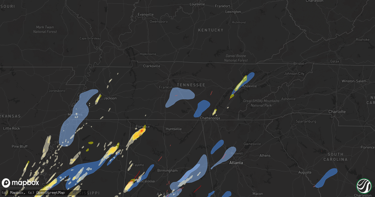
Hail Map in Tennessee on March 15, 2025
Get this storm
March 15 map
$229
one time, instant access
Download today. No call, no setup
Keep the $229
Bought the map and want the full workflow? Apply the entire $229 to a subscription within 7 days. None of it is wasted.
Every map, not just this one
This buys you this map. Subscription and you get every map we run, in the markets you choose from a few cities to whole states to nationwide. Plus real-time alerts the moment a storm fires.
Contact data
Name, contact info, occupancy, even credit band for addresses in the footprint. You go from where it hit to who to call.
Become the source they trust
Unlimited branding weather history reports on demand. You already have the documented answer ready for the property owner, and you are the one who showed up with it.
Property data and RoofTrace estimates
Pull up any address you have got, its value and the exact code rules for that jurisdiction, straight from One Click Code. Then RoofTrace estimates the squares, pitch, and roof value, priced the way you price.
Storm reports in Tennessee
Tennessee
| Date | Description |
|---|---|
| 03/15/20256:53 PM CDT | A few trees down. |
| 03/15/20256:45 PM CDT | Trees down. |
| 03/15/20256:35 PM CDT | Trees down. Trees were twisted. |
| 03/15/20256:12 PM CDT | Several trees down and 1 inch hail. |
| 03/15/20256:11 PM CDT | Several trees down. |
| 03/15/20255:53 PM CDT | Report from mping: quarter |
| 03/15/20255:50 PM CDT | Hail up to 1 inch was photographed in lakesite... Tn. |
| 03/15/20255:30 PM CDT | Several trees were blown down and minor structure damage was reported on the north side of jamestown near fairgrounds rd. |
| 03/15/20255:30 PM CDT | Few trees down. |
| 03/15/20255:09 PM CDT | Few trees down. |
| 03/15/20255:00 PM CDT | Trees down and structure damage to homes in palmer. Time estimated by radar. |
| 03/15/20254:15 PM CDT | Numerous downed trees were reported in the mcminnville area. Time estimate from radar. |
| 03/15/20254:03 PM CDT | Debris blocking i-24 east at mile marker 89.2 in rutherford county. Tree across roadway with all eastbound lanes blocked. |
| 03/15/20253:58 PM CDT | Rutherford county fire working 2 reports of large trees blocking roadways in christiana. 6700blk williams rd... 4500blk jones rd. |
| 03/15/20253:55 PM CDT | Tree uprooted and damage to a metal building was reported near christiana. |
| 03/15/20253:45 PM CDT | Trees were blown down and blocking the road along jacobs hollow rd near bradyville pike. Time estimated by radar. |
| 03/15/20253:30 PM CDT | A local report indicates 61 MPH wind near 5 N Shelbyville |
| 03/15/20253:30 PM CDT | Trees were blown down at webb rd and barfield-crescent rd. Time was estimated by radar. |
| 03/15/20253:30 PM CDT | A privacy fence was blown down... Partially blocking road along rucker rd near county farm rd. |
| 03/15/20253:19 PM CDT | Relayed from a tspotter... Damage to a powerline and a tree at the intersection of longview road and pepper hill. |
| 03/15/20253:18 PM CDT | Possible structure damage near kingdom road. Tspotter. |
| 03/15/20253:08 PM CDT | Relayed via social media... Photo of tree snapped and power pole down on blue creek road. |
| 03/15/202510:10 AM CDT | A local report indicates 1.00 inch wind near 3 SSE Athens |
| 03/15/20258:40 AM CDT | Estimated 60 mph winds at nws memphis office. |
| 03/15/20258:30 AM CDT | A local report indicates 1.00 inch wind near 1 WNW Brownsville |
| 03/15/20257:27 AM CDT | Winds lofted a carport in pocahontas. |
| 03/15/20252:08 AM CDT | Trees and powerlines down all over the county. |
| 03/14/20259:12 PM CDT | Roof and out building damage... Suspected to be from straight-line winds. |
| 03/14/20258:00 PM CDT | A local report indicates 1.00 inch wind near 2 WSW Melvine |
| 03/14/20257:56 PM CDT | Several trees down. |
| 03/14/20257:45 PM CDT | A local report indicates 1.00 inch wind near 2 WSW Andersonville |
| 03/14/20257:30 PM CDT | Several trees down in the heiskell area. |
| 03/14/20257:23 PM CDT | Report from mping: quarter |
| 03/14/20257:20 PM CDT | Lots of hail observed in oak ridge. Largest was reported to be grape sized... Roughly 1 inch. |
| 03/14/20257:20 PM CDT | A local report indicates 1.00 inch wind near 6 NE Oak Ridge |
| 03/14/20257:00 PM CDT | Trees down over parts of the county. |
| 03/14/20257:00 PM CDT | A couple of trees down. |
All States Impacted by Hail Map on March 15, 2025
Cities Impacted by Hail Map on March 15, 2025
- Choudrant, LA
- Ruston, LA
- Dubach, LA
- Farmerville, LA
- Bernice, LA
- Monticello, AR
- Marion, LA
- Cordova, TN
- Hernando, MS
- Dundee, MS
- Hughes, AR
- Mason, TN
- Crenshaw, MS
- Millington, TN
- Coldwater, MS
- Marion, AR
- Southaven, MS
- Nesbit, MS
- Germantown, TN
- Arlington, TN
- Senatobia, MS
- Memphis, TN
- Sledge, MS
- Lyon, MS
- Marianna, AR
- Eads, TN
- Clarksdale, MS
- Helena, AR
- Tunica, MS
- Proctor, AR
- Coahoma, MS
- Robinsonville, MS
- Walls, MS
- Collierville, TN
- Brickeys, AR
- Horn Lake, MS
- Lake Cormorant, MS
- Sarah, MS
- Olive Branch, MS
- Como, MS
- Marks, MS
- Sardis, MS
- Batesville, MS
- West Memphis, AR
- Bells, TN
- Brownsville, TN
- Stanton, TN
- Florien, LA
- Vincent, OH
- Dermott, AR
- Lake Village, AR
- Wiergate, TX
- Hemphill, TX
- Columbia, LA
- West Monroe, LA
- Tichnor, AR
- Fresno, OH
- Somerville, TN
- Portland, AR
- Parkdale, AR
- Monroe, LA
- Collinston, LA
- Oak Ridge, LA
- Drummonds, TN
- Atoka, TN
- Oakland, TN
- Munford, TN
- Brighton, TN
- Watson, AR
- Boyle, MS
- Snow Lake, AR
- Poplar Grove, AR
- Marvell, AR
- Holly Grove, AR
- Elaine, AR
- Humboldt, TN
- Hamburg, AR
- Montrose, AR
- Arkansas City, AR
- Rohwer, AR
- Benoit, MS
- Crossett, AR
- Quitman, LA
- Byhalia, MS
- Spearsville, LA
- Rosedale, MS
- Gunnison, MS
- Beulah, MS
- Shelby, MS
- Mound Bayou, MS
- Burlison, TN
- Covington, TN
- Clarendon, AR
- Dodson, LA
- Sikes, LA
- Campbellsburg, KY
- New Liberty, KY
- Sanders, KY
- Turners Station, KY
- Owenton, KY
- Worthville, KY
- Alligator, MS
- Chatham, LA
- Duncan, MS
- McGehee, AR
- Tillar, AR
- Eros, LA
- Crumrod, AR
- Mellwood, AR
- Many, LA
- Fisher, LA
- Fountain Hill, AR
- Saulsbury, TN
- Grand Junction, TN
- Holly Springs, MS
- Cleveland, MS
- Merigold, MS
- Jonesboro, LA
- Harrisville, WV
- Cairo, WV
- Ripley, TN
- Henning, TN
- Osceola, AR
- Rayville, LA
- Mangham, LA
- Greenville, MS
- Trenton, TN
- Hornsby, TN
- Henderson, TN
- Bolivar, TN
- Bastrop, LA
- Sterlington, LA
- Little Hocking, OH
- Washington, WV
- Robeline, LA
- Provencal, LA
- Walker, WV
- Petroleum, WV
- Gleason, TN
- Paris, TN
- Pennsboro, WV
- Gates, TN
- Atlanta, LA
- Winnfield, LA
- Alamo, TN
- Melrose, LA
- Natchez, LA
- Pioneer, LA
- Natchitoches, LA
- Montgomery, LA
- Epps, LA
- Shaw, MS
- Halls, TN
- Friendship, TN
- Lake Providence, LA
- Oak Grove, LA
- Transylvania, LA
- Indianola, MS
- Mayersville, MS
- Montgomery, IN
- Cannelburg, IN
- Otwell, IN
- Jasper, IN
- Ruleville, MS
- Doddsville, MS
- Goldonna, LA
- Rolling Fork, MS
- Glen Allan, MS
- Hollandale, MS
- Chatham, MS
- Minter City, MS
- Anguilla, MS
- Loogootee, IN
- Bardwell, KY
- Philipp, MS
- Winnsboro, LA
- Fort Necessity, LA
- Schlater, MS
- Greenwood, MS
- Charleston, MS
- Belzoni, MS
- Tallulah, LA
- Holcomb, MS
- Scobey, MS
- Cascilla, MS
- Tillatoba, MS
- Melber, KY
- Cunningham, KY
- Isola, MS
- Oakland, MS
- Pope, MS
- Courtland, MS
- Water Valley, MS
- Inverness, MS
- Itta Bena, MS
- Sidon, MS
- Moorhead, MS
- Oxford, MS
- Taylor, MS
- Tchula, MS
- Carrollton, MS
- Cruger, MS
- Yazoo City, MS
- Lexington, MS
- Kentwood, LA
- Coila, MS
- Winona, MS
- McCarley, MS
- Durant, MS
- Duck Hill, MS
- Grenada, MS
- West, MS
- Vaiden, MS
- North Carrollton, MS
- Houston, MS
- Houlka, MS
- Osyka, MS
- Magnolia, MS
- Mccomb, MS
- Okolona, MS
- Tylertown, MS
- Eupora, MS
- Gore Springs, MS
- Stewart, MS
- Kilmichael, MS
- Calhoun City, MS
- Kokomo, MS
- Jayess, MS
- Foxworth, MS
- Bellefontaine, MS
- Woodland, MS
- Vardaman, MS
- Walthall, MS
- Mantee, MS
- Columbia, MS
- Sondheimer, LA
- Vicksburg, MS
- Saint Francisville, LA
- Woodville, MS
- Centreville, MS
- Norwood, LA
- Oak Vale, MS
- Carson, MS
- Aberdeen, MS
- Maben, MS
- Mathiston, MS
- Prentiss, MS
- Bassfield, MS
- Olla, LA
- Tullos, LA
- Jackson, LA
- Raleigh, MS
- Brookhaven, MS
- Livonia, LA
- Fordoche, LA
- Oscar, LA
- Lottie, LA
- Pride, LA
- Clinton, LA
- Slaughter, LA
- Gloster, MS
- Kelly, LA
- Collins, MS
- Tremont, MS
- Vina, AL
- Newton, MS
- Decatur, MS
- Lawrence, MS
- Zachary, LA
- Lake, MS
- Benton, MS
- Grayson, LA
- New Roads, LA
- Ventress, LA
- Jarreau, LA
- Greensburg, LA
- Mize, MS
- Red Bay, AL
- Russellville, AL
- Spruce Pine, AL
- Hodges, AL
- Plantersville, MS
- Tupelo, MS
- Nettleton, MS
- Golden, MS
- Vaughan, MS
- Ethel, LA
- Meadville, MS
- Shannon, MS
- Pontotoc, MS
- Pickens, MS
- Wesson, MS
- Greenwell Springs, LA
- Liberty, MS
- Mount Olive, MS
- McCall Creek, MS
- Taylorsville, MS
- Tuscumbia, AL
- Fulton, MS
- Sontag, MS
- Canton, MS
- Bentonia, MS
- Delhi, LA
- Verona, MS
- Forest, MS
- Little Rock, MS
- Amory, MS
- Pinola, MS
- Muscle Shoals, AL
- Goodman, MS
- Thaxton, MS
- De Kalb, MS
- Daleville, MS
- Summit, MS
- Braxton, MS
- Walker, LA
- Denham Springs, LA
- Pine Grove, LA
- Mooreville, MS
- Mantachie, MS
- Cherokee, AL
- Leighton, AL
- Sallis, MS
- Madison, MS
- Sheffield, AL
- Scooba, MS
- Porterville, MS
- Florence, AL
- Vernon, AL
- Aliceville, AL
- Emelle, AL
- Leland, MS
- Eutaw, AL
- Macon, MS
- Carrollton, AL
- Gordo, AL
- Roseland, LA
- Belden, MS
- Amite, LA
- Camden, MS
- Boligee, AL
- Ralph, AL
- Knoxville, AL
- Buhl, AL
- Fluker, LA
- Bay Springs, MS
- Mount Hermon, LA
- Elrod, AL
- Franklinton, LA
- Echola, AL
- Northport, AL
- Coker, AL
- Morenci, MI
- Clayton, MI
- Sand Creek, MI
- Adrian, MI
- Palmyra, MI
- Berry, AL
- Tuscaloosa, AL
- Iron City, TN
- Westpoint, TN
- Husser, LA
- Clinton, MI
- Tecumseh, MI
- Britton, MI
- Saline, MI
- Oakman, AL
- Loranger, LA
- Mendenhall, MS
- Rose Hill, MS
- Pachuta, MS
- Prairie, MS
- Ann Arbor, MI
- Ypsilanti, MI
- Milan, MI
- Plymouth, MI
- South Lyon, MI
- Northville, MI
- New Hudson, MI
- Milford, MI
- Wixom, MI
- Novi, MI
- Canton, MI
- Parrish, AL
- Hahnville, LA
- Reform, AL
- Commerce Township, MI
- Walled Lake, MI
- White Lake, MI
- West Bloomfield, MI
- Saint Rose, LA
- Kenner, LA
- Fayette, AL
- Meridian, MS
- Metairie, LA
- Ponchatoula, LA
- Cullman, AL
- Norco, LA
- Destrehan, LA
- Luling, LA
- Lacombe, LA
- Pikeville, TN
- Spencer, TN
- Cordova, AL
- Jasper, AL
- Empire, AL
- Bremen, AL
- Harrison, TN
- Ooltewah, TN
- Pearl River, LA
- Slidell, LA
- Hixson, TN
- Soddy Daisy, TN
- Stennis Space Center, MS
- Ellisville, MS
- Ovett, MS
- Chattanooga, TN
- Laurel, MS
- Smithville, MS
- Demopolis, AL
- Linden, AL
- Greenwood Springs, MS
- Hamilton, AL
- Diberville, MS
- Biloxi, MS
- Vancleave, MS
- Richton, MS
- Waynesboro, MS
- State Line, MS
- Gallion, AL
- Millport, AL
- Ethelsville, AL
- Lucedale, MS
- Niota, TN
- Sweetwater, TN
- Philadelphia, TN
- Loudon, TN
- Marion, AL
- Wilmer, AL
- Citronelle, AL
- Chunchula, AL
- Kingston, TN
- Oak Ridge, TN
- Pass Christian, MS
- Bay Saint Louis, MS
- Waveland, MS
- Newbern, AL
- Lenoir City, TN
- Faunsdale, AL
- Harriman, TN
- Oliver Springs, TN
- Clinton, TN
- Rocky Top, TN
- Andersonville, TN
- Norris, TN
- Heiskell, TN
- Sunflower, AL
- Wagarville, AL
- Centreville, AL
- Lawley, AL
- Calera, AL
- Montevallo, AL
- Thomaston, AL
- Magnolia, AL
- Grove Hill, AL
- Whatley, AL
- Leroy, AL
- Jackson, AL
- McIntosh, AL
- Deer Park, AL
- Uniontown, AL
- Catherine, AL
- Safford, AL
- Marion Junction, AL
- Talladega, AL
- Riceville, TN
- Moss Point, MS
- Clanton, AL
- Selma, AL
- Plantersville, AL
- Sylacauga, AL
- Goodwater, AL
- Maplesville, AL
- Stanton, AL
- Jemison, AL
- Columbiana, AL
- Shelby, AL
- Childersburg, AL
- Alpine, AL
- Munford, AL
- Oxford, AL
- Anniston, AL
- Lineville, AL
- Ashland, AL
- Delta, AL
- Heflin, AL
- Millerville, AL
- Weogufka, AL
- Jones, AL
- Billingsley, AL
- Marbury, AL
- Verbena, AL
- Rockford, AL
- Autaugaville, AL
- Prattville, AL
- Mobile, AL
- Irvington, AL
- Theodore, AL
- Piedmont, AL
- Jacksonville, AL
- Fruithurst, AL
- Woodland, AL
- Wedowee, AL
- Daphne, AL
- Bay Minette, AL
- Stapleton, AL
- Ranburne, AL
- Muscadine, AL
- McDavid, FL
- Century, FL
- Atmore, AL
- Brantley, AL
- Luverne, AL
- Jacksons Gap, AL
- Dadeville, AL
- Hope Hull, AL
- Montgomery, AL
- Troy, AL
- Glenwood, AL
- Goshen, AL
- Banks, AL
- Sugarcreek, OH
- Baltic, OH
- Stone Creek, OH
- New Philadelphia, OH
- Brundidge, AL
- Union Springs, AL
- Midway, AL
- Clayton, AL
- Louisville, AL
- Ozark, AL
- Enterprise, AL
- Ariton, AL
- Jack, AL
- Eufaula, AL
- Lumpkin, GA
- Omaha, GA
- Bradford, TN
- Greenfield, TN
- Chipley, FL
- Blakely, GA
- Paducah, KY
- Colquitt, GA
- Coshocton, OH
- Camilla, GA
- Cordele, GA
- Pelham, GA
- Vienna, GA
- Sale City, GA
- Cornersville, TN
- Culleoka, TN
- Lewisburg, TN
- Lynnville, TN
- Belfast, TN
- Shelbyville, TN
- Petersburg, TN
- Unionville, TN
- Chapel Hill, TN
- Arrington, TN
- College Grove, TN
- Eagleville, TN
- Rockvale, TN
- Bell Buckle, TN
- Christiana, TN
- Murfreesboro, TN
- Smyrna, TN
- Wartrace, TN
- Manchester, TN
- Bradyville, TN
- Beechgrove, TN
- Readyville, TN
- Morrison, TN
- Woodbury, TN
- Mcminnville, TN
- South Pittsburg, TN
- Sewanee, TN
- Monteagle, TN
- Tracy City, TN
- Sequatchie, TN
- Jasper, TN
- Whitwell, TN
- Palmer, TN
- Coalmont, TN
- Gruetli Laager, TN
- Altamont, TN
- Beersheba Springs, TN
- Dunlap, TN
- Knoxville, TN
- Powell, TN
- Sharps Chapel, TN
- Maynardville, TN
- Corryton, TN
- Luttrell, TN
- Pheba, MS
- Cedarbluff, MS
- West Point, MS
- Seminary, MS
- Sumrall, MS
- Enterprise, MS
- Hattiesburg, MS
- Purvis, MS
- Daviston, AL
- Auburn, AL
- Opelika, AL
- Hurtsboro, AL
- Salem, AL
- Phenix City, AL
- Smiths Station, AL
- Columbus, GA
- Fortson, GA
- Cataula, GA
- Hamilton, GA
- Pine Mountain Valley, GA
- Warm Springs, GA
- Shiloh, GA
- Pine Mountain, GA
- Manchester, GA
- Waverly Hall, GA
- Woodland, GA
- Ellerslie, GA
- Lafayette, AL
- Cusseta, AL
- Lanett, AL
- Valley, AL
- West Point, GA
- Lagrange, GA
- Dallas, GA
- Bowdon, GA
- Carrollton, GA
- Waco, GA
- Bremen, GA
- Temple, GA
- Villa Rica, GA
- Powder Springs, GA
- Douglasville, GA
- Hiram, GA
- Kennesaw, GA
- Acworth, GA
- Marietta, GA
- Woodstock, GA
- Canton, GA
- Cartersville, GA
- Austell, GA
- Roswell, GA
- Cedartown, GA
- Silver Creek, GA
- Rome, GA
- Lindale, GA
- Cave Spring, GA
- Aragon, GA
- Taylorsville, GA
- Kingston, GA
- Adairsville, GA
- Elba, AL
- New Brockton, AL
- Fort Rucker, AL
- Skipperville, AL
- Clio, AL
- Clopton, AL
- Pittsview, AL
- Meigs, GA
- Baconton, GA
- Albany, GA
- Doerun, GA
- Sylvester, GA
- Hartsfield, GA
- Sumner, GA
- Girard, GA
- Martin, SC
- Sylvania, GA
- Barnwell, SC
- Allendale, SC
- Ulmer, SC
- Olar, SC
- Blackville, SC
- Williston, SC
- Denmark, SC
- Norway, SC
- Cope, SC
- Bamberg, SC
- Cordova, SC
- Orangeburg, SC
- Neeses, SC
- Chapin, SC


