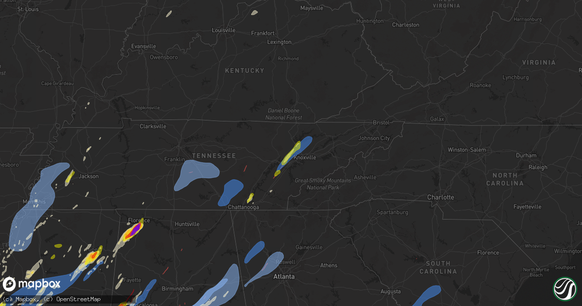
Hail Map on March 15, 2025
Get this storm
March 15 map
$229
one time, instant access
Download today. No call, no setup
Keep the $229
Bought the map and want the full workflow? Apply the entire $229 to a subscription within 7 days. None of it is wasted.
Every map, not just this one
This buys you this map. Subscription and you get every map we run, in the markets you choose from a few cities to whole states to nationwide. Plus real-time alerts the moment a storm fires.
Contact data
Name, contact info, occupancy, even credit band for addresses in the footprint. You go from where it hit to who to call.
Become the source they trust
Unlimited branding weather history reports on demand. You already have the documented answer ready for the property owner, and you are the one who showed up with it.
Property data and RoofTrace estimates
Pull up any address you have got, its value and the exact code rules for that jurisdiction, straight from One Click Code. Then RoofTrace estimates the squares, pitch, and roof value, priced the way you price.
States Impacted by Hail Map on March 15, 2025
Storm reports
South Carolina
| Date | Description |
|---|---|
| 03/15/20256:48 AM CDT | Broadcast media sent multiple pictures of trees down near the intersection of old bush river rd and wessinger rd. They also noted a power crew was working on island trl |
| 03/15/20256:38 AM CDT | A national weather service storm survey team determined that a tornado formed over lake murray near dreher island at 7:38 am local time... Causing high end ef-0 to low |
| 03/15/20256:29 AM CDT | Highway patrol reported power lines down near the intersection of ira kinard road and blacksgate east. |
| 03/15/20256:10 AM CDT | Report from public via media of multiple trees down near fairway lane at sweetwater country club. Nws survey team will check for a possible tornado on monday. |
Florida
| Date | Description |
|---|---|
| 03/15/20256:35 AM CDT | Fallen trees or limbs resulted in a power outage. |
| 03/15/20256:12 AM CDT | Tree and powerlines reported down near moccasin gap rd and w veterans memorial. |
| 03/15/20256:00 AM CDT | Mesonet station 0742w fswn wakulla shell point beach reported a gust of 66 mph. |
| 03/15/20255:45 AM CDT | Power lines reported down near sr 65 and forest rd 181. |
| 03/15/20255:00 AM CDT | Powerlines reported down in port st joe on hwy 71 and ave a. |
| 03/15/20253:45 AM CDT | A tree was reported down on a car in sneads. |
| 03/15/20253:30 AM CDT | Trees reported down on hwy 162. |
| 03/15/20252:42 AM CDT | Tree reported down on mayhaw ln. |
Tennessee
| Date | Description |
|---|---|
| 03/15/20256:53 PM CDT | A few trees down. |
| 03/15/20256:45 PM CDT | Trees down. |
| 03/15/20256:35 PM CDT | Trees down. Trees were twisted. |
| 03/15/20256:12 PM CDT | Several trees down and 1 inch hail. |
| 03/15/20256:11 PM CDT | Several trees down. |
| 03/15/20255:53 PM CDT | Report from mping: quarter |
| 03/15/20255:50 PM CDT | Hail up to 1 inch was photographed in lakesite... Tn. |
| 03/15/20255:30 PM CDT | Few trees down. |
| 03/15/20255:30 PM CDT | Several trees were blown down and minor structure damage was reported on the north side of jamestown near fairgrounds rd. |
| 03/15/20255:09 PM CDT | Few trees down. |
| 03/15/20255:00 PM CDT | Trees down and structure damage to homes in palmer. Time estimated by radar. |
| 03/15/20254:15 PM CDT | Numerous downed trees were reported in the mcminnville area. Time estimate from radar. |
| 03/15/20254:03 PM CDT | Debris blocking i-24 east at mile marker 89.2 in rutherford county. Tree across roadway with all eastbound lanes blocked. |
| 03/15/20253:58 PM CDT | Rutherford county fire working 2 reports of large trees blocking roadways in christiana. 6700blk williams rd... 4500blk jones rd. |
| 03/15/20253:55 PM CDT | Tree uprooted and damage to a metal building was reported near christiana. |
| 03/15/20253:45 PM CDT | Trees were blown down and blocking the road along jacobs hollow rd near bradyville pike. Time estimated by radar. |
| 03/15/20253:30 PM CDT | Trees were blown down at webb rd and barfield-crescent rd. Time was estimated by radar. |
| 03/15/20253:30 PM CDT | A privacy fence was blown down... Partially blocking road along rucker rd near county farm rd. |
| 03/15/20253:30 PM CDT | A local report indicates 61 MPH wind near 5 N Shelbyville |
| 03/15/20253:19 PM CDT | Relayed from a tspotter... Damage to a powerline and a tree at the intersection of longview road and pepper hill. |
| 03/15/20253:18 PM CDT | Possible structure damage near kingdom road. Tspotter. |
| 03/15/20253:08 PM CDT | Relayed via social media... Photo of tree snapped and power pole down on blue creek road. |
| 03/15/202510:10 AM CDT | A local report indicates 1.00 inch wind near 3 SSE Athens |
| 03/15/20258:40 AM CDT | Estimated 60 mph winds at nws memphis office. |
| 03/15/20258:30 AM CDT | A local report indicates 1.00 inch wind near 1 WNW Brownsville |
| 03/15/20257:27 AM CDT | Winds lofted a carport in pocahontas. |
| 03/15/20252:08 AM CDT | Trees and powerlines down all over the county. |
| 03/14/20259:12 PM CDT | Roof and out building damage... Suspected to be from straight-line winds. |
| 03/14/20258:00 PM CDT | A local report indicates 1.00 inch wind near 2 WSW Melvine |
| 03/14/20257:56 PM CDT | Several trees down. |
| 03/14/20257:45 PM CDT | A local report indicates 1.00 inch wind near 2 WSW Andersonville |
| 03/14/20257:30 PM CDT | Several trees down in the heiskell area. |
| 03/14/20257:23 PM CDT | Report from mping: quarter |
| 03/14/20257:20 PM CDT | A local report indicates 1.00 inch wind near 6 NE Oak Ridge |
| 03/14/20257:20 PM CDT | Lots of hail observed in oak ridge. Largest was reported to be grape sized... Roughly 1 inch. |
| 03/14/20257:00 PM CDT | A couple of trees down. |
| 03/14/20257:00 PM CDT | Trees down over parts of the county. |
Alabama
| Date | Description |
|---|---|
| 03/15/20256:52 PM CDT | Trees down blocking the road on al-61... And near cr-16... Both in and near newbern. Possible tornado. |
| 03/15/20256:44 PM CDT | Trees down on al-25 and cr-57... In the southern part of hale county. Possible tornado. |
| 03/15/20256:42 PM CDT | Report of a tree down at 6000 county rd 8 in woodville al from ema. |
| 03/15/20255:28 PM CDT | Seven to 10 large trees down... Blocking cr-13 near the alumuchee creek bridge. Possible tornado. Time estimated by radar. |
| 03/15/20254:52 PM CDT | Several houses with significant damage... And possible injuries... On campbellville road northeast of sipsey. Tds observed on radar at the time. |
| 03/15/20254:50 PM CDT | Fire department responding to numerous reports of trees down... Including some on houses... In sipsey. |
| 03/15/20254:45 PM CDT | Numerous trees snapped on us-82... Near the northwest city limits of gordo. |
| 03/15/20254:40 PM CDT | Trees down. Reported by 911 center. Possible tornado. |
| 03/15/20254:31 PM CDT | Trees down. Possible tornado. |
| 03/15/20254:31 PM CDT | Trees down on paul bolton road. Possible tornado. |
| 03/15/20254:23 PM CDT | Several large trees down on al-69... Just south of the tuscaloosa and walker county line. Possible tornado. |
| 03/15/20254:10 PM CDT | Trees and power lines down on al-69... Between buffalo ridge road and yellow creek road. Lots of debris on the road. Possible tornado. |
| 03/15/20254:10 PM CDT | Tree downed in the 100 block of kentucky ave in sheffield. Time estimated from radar. |
| 03/15/20254:10 PM CDT | Trees and power lines down on al-69... Between buffalo ridge road and yell |
| 03/15/20254:04 PM CDT | Tree down blocking highway 43. |
| 03/15/20254:02 PM CDT | Numerous reports of trees down around the samantha and lake tuscaloosa areas... Including tierce patton road. Possible tornado. |
| 03/15/20253:41 PM CDT | Numerous trees snapped. A few trees uprooted. At least one house with roof damage. Spotter saw the tornado cross us-82 near minas road. |
| 03/15/20252:45 PM CDT | Several trees uprooted. |
| 03/15/20252:45 PM CDT | Several trees down. |
| 03/15/20252:39 PM CDT | Emergency management reported quarter size hail one mile west of shoal creek on highway 72. |
| 03/15/20252:35 PM CDT | Estimated ping pong ball sized hail. |
| 03/15/20252:34 PM CDT | Social media report received for 1.25 inch hail. |
| 03/15/20252:30 PM CDT | Estimated 1 inch hail was reported in killen. |
| 03/15/20252:26 PM CDT | Emergency management reported baseball size hail in the colbert heights community. |
| 03/15/20252:20 PM CDT | Tree downed in the 900 block of north montgomery ave in sheffield. Time estimated by radar. |
| 03/15/20252:20 PM CDT | Social media report received with photo of 2 inch hail. |
| 03/15/20252:20 PM CDT | Report of a tree down from 911 call center at the corner s blackwell rd and w wheeler ave. |
| 03/15/20252:20 PM CDT | Tree downed near the garage and cherokee roads intersection. Time estimated from radar. |
| 03/15/20252:15 PM CDT | Report of a tree down from 911 call center at the corner of gusmus ave and louise ave. |
| 03/15/20252:13 PM CDT | Emergency management reported ping pong ball sized hail in new bethel alabama. |
| 03/15/202512:45 AM CDT | Several trees reported down across coffee county. |
| 03/15/202512:45 AM CDT | Several trees down on oak bowery and grand national. |
| 03/15/202512:15 AM CDT | Trees reported down across various parts of russell county. |
| 03/14/202511:52 PM CDT | Several trees down on oak bowery and grand national. Corrected for time based on radar. |
| 03/14/202511:15 PM CDT | Reports of trees down across upper river road in tallassee. |
| 03/14/202511:11 PM CDT | Downed trees. Damage to residences with one mh rolled and destroyed. Probable tornado. |
| 03/14/202511:02 PM CDT | Damage along highway 231 involving downed utility poles... Busted out business signs... Downed trees. Probable tornado. |
| 03/14/202511:02 PM CDT | Trees snapped and uprooted. Possible tornado. |
| 03/14/202510:49 PM CDT | Trees down involving a camper and shed. Possible tornado. |
| 03/14/20259:59 PM CDT | Trees down in the deatsville area. |
| 03/14/20259:57 PM CDT | Various reports of trees and powerlines down across northeastern autauga county. |
| 03/14/20259:28 PM CDT | Awos station kanb measured a gust of 77 mph. |
| 03/14/20259:22 PM CDT | Trees blown down in the oxford area... At least one onto a residence. |
| 03/14/20259:05 PM CDT | At le |
| 03/14/20259:05 PM CDT | At least 2 houses and one manufactured home received damage near the cr-15 and cr-16 area of chilton county. |
| 03/14/20259:02 PM CDT | Damage to a metal roof of a home. Time estimated by radar. |
| 03/14/20259:02 PM CDT | Extensive damage reported reported on us-82 near maplesville. Tds observed on radar. |
| 03/14/20258:56 PM CDT | Trees blown down in the vicinity of highway 77 and mountain view road. Time estimated from radar. |
| 03/14/20258:54 PM CDT | Extensive damage in plantersville. |
| 03/14/20258:53 PM CDT | Trees blown down on the southeast side of talladega. |
| 03/14/20258:53 PM CDT | Structural damage and trees down in the vicinity of lovelady drive and cr 63. Tds appeared on the following radar scan. |
| 03/14/20258:50 PM CDT | Trees blown down. |
| 03/14/20258:47 PM CDT | Trees down at cr 222 and hwy 22. Tds appeared on the following scan. |
| 03/14/20258:43 PM CDT | Damage reported at winterboro high school. |
| 03/14/20258:42 PM CDT | Tree on a house just off highway 21. No injuries. |
| 03/14/20258:33 PM CDT | Trees down in the sylacauga area. |
| 03/14/20258:32 PM CDT | Trees blown down. |
| 03/14/20258:21 PM CDT | Several trees down in the quail run area. |
| 03/14/20258:19 PM CDT | Several reports of damage near the i-65/us-31 intersection near calera... Including businesses and homes. |
| 03/14/20258:02 PM CDT | Extensive damage to a trailer park in the city of calera. Possible tornado. |
| 03/14/20258:00 PM CDT | An ef-1 tornado was confirmed by nws meteorologists... Affecting areas between montevallo and calera. |
| 03/14/20257:57 PM CDT | An ef-1 tornado was confirmed by nws meteorologists... Affecting the calera area. |
| 03/14/20257:39 PM CDT | An ef-0 tornado was confirmed by nws meteorologists... Affecting southeast bibb county near thomas mill. |
Missouri
| Date | Description |
|---|---|
| 03/15/20253:29 PM CDT | Roof blown off house at 345 bradshaw west alton as well as power poles and out buildings down. |
Louisiana
| Date | Description |
|---|---|
| 03/15/20255:01 PM CDT | A local report indicates 1.00 inch wind near 1 WNW Kenner |
| 03/15/20254:56 PM CDT | Mesonet station xptn pontchartrain causeway. |
| 03/15/20254:44 PM CDT | Report from mping: quarter |
| 03/15/20254:39 PM CDT | Quarter size hail. |
| 03/15/20254:26 PM CDT | Trees and powerlines damaged near three rivers rd and wolverine dr. Possible tornado. |
| 03/15/20254:23 PM CDT | Trees down along interstate 12 and 190. Possible tornado. |
| 03/15/202512:19 PM CDT | Structural damage and roads blocked; likely tornado. |
| 03/15/202511:40 AM CDT | Reports of trees damaged at holloway... La at ol mels farm and on hickory grove loop. |
| 03/15/202511:10 AM CDT | Video and picture of tornado in slack via knoe monroe la abby ezell. |
| 03/15/202510:56 AM CDT | Report of multiple trees downed along hwy-65s as well as damage to residences and businesses in downtown lake providence. |
| 03/15/202510:08 AM CDT | Corrects previous tstm wnd dmg report from 1 sse lake providence. Report of multiple trees downed along hwy-65s as well as damage to residences and businesses in downto |
| 03/15/20259:48 AM CDT | A 100x200 foot farm shop was destroyed along fish hatchery road between natchitoches and natchez. |
| 03/15/20259:00 AM CDT | Ping pong ball size hail fell on toro bay drive in the toro community. |
| 03/15/20258:29 AM CDT | Multiple large tree limbs down in this area according to an mping report. |
| 03/15/20258:05 AM CDT | Report of downed tree. |
| 03/15/20257:40 AM CDT | Corrects previous non-tstm wnd dmg report from 1 wsw atlanta. Reports of powerlines down on highway 471 southwest of atlanta. |
| 03/15/20257:26 AM CDT | Mping report. |
| 03/15/20257:00 AM CDT | Report via social media with picture. |
Ohio
| Date | Description |
|---|---|
| 03/15/20252:50 PM CDT | A local report indicates 60 MPH wind near 5 SSW Mcgill |
| 03/15/20257:20 AM CDT | Quarter size hail report in sugarcreek relayed by broadcast media. Time estimated via radar. |
Mississippi
| Date | Description |
|---|---|
| 03/15/20254:43 PM CDT | Trees down along hwy 45. |
| 03/15/20254:18 PM CDT | Trees and power lines downed on the north end of lake eddins. Trees down on multiple houses... A garage destroyed... And a boat house destroyed. |
| 03/15/20254:13 PM CDT | Reports of multiple power flashes on 192 watts rd. Possible tornado. |
| 03/15/20254:11 PM CDT | Trees downed on cr 16. |
| 03/15/20253:20 PM CDT | Tds and multiple structures damaged at and near hwy 49. |
| 03/15/20253:12 PM CDT | Report of extensive tree damage and downed trees blocking hwy-531. |
| 03/15/20253:08 PM CDT | Large tds... Damage reported by em. |
| 03/15/20253:04 PM CDT | Damage reported along bethel church rd. |
| 03/15/20252:55 PM CDT | Corrects previous tornado report from 4 sw bay springs. Report of extensive tree damage and downed trees blocking hwy-531. |
| 03/15/20252:38 PM CDT | Path of trees downed crossing cr 23. |
| 03/15/20252:27 PM CDT | Local law enforcement reported multiple trees and powerlines down on new salem rd. |
| 03/15/20252:24 PM CDT | A local report indicates 58 MPH wind near 4 SE Hattiesburg |
| 03/15/20252:20 PM CDT | Large tds... Damage reported by em. |
| 03/15/20252:16 PM CDT | Tds. |
| 03/15/20252:10 PM CDT | Pictures posted of swath of trees snapped with some uprooted... Damage to metal structure and damage to tractor trailers. |
| 03/15/20252:05 PM CDT | Reported golf ball sized hail in shannon area of lee county. |
| 03/15/20252:05 PM CDT | Report of extensive tree damage along hwy-37 and damage to the roof of a structure. |
| 03/15/20252:05 PM CDT | Report of extensive tree damage along hwy-37 and damage to the roof of a structure. |
| 03/15/20251:58 PM CDT | Tornado observed west of hot coffee. |
| 03/15/20251:54 PM CDT | Law enforcement reported multiple trees down near hwy 472 along with marble size hail. |
| 03/15/20251:45 PM CDT | Tds... Damage reported by em. |
| 03/15/20251:44 PM CDT | Trees and powerlines downed at ms 503 and ac thompson rd. |
| 03/15/20251:39 PM CDT | Tds... Damage reported by em. |
| 03/15/20251:34 PM CDT | A stand of trees snapped along the natchez trace parkway near the van vleet community. Possible tornado. |
| 03/15/20251:31 PM CDT | Delayed report - multiple trees down and power outages in the houston area. Time estimated via radar. |
| 03/15/20251:31 PM CDT | Large tds... Damage reported by em. |
| 03/15/20251:25 PM CDT | Extensive damage; likely tornado. |
| 03/15/20251:23 PM CDT | Large tds... Damage reported by em. |
| 03/15/20251:22 PM CDT | Law enforcement reported a tree down on loring rd. Both lanes of traffic are blocked. |
| 03/15/20251:16 PM CDT | Tds at hwy 13... Damage reported by em. |
| 03/15/20251:15 PM CDT | Delayed report - tree trunks snapped along highway 371 north of bigbee. |
| 03/15/20251:12 PM CDT | Large tree on home on parkview st. |
| 03/15/20251:04 PM CDT | Large tds... Also damage reported from em. |
| 03/15/202512:55 PM CDT | Damage to sheds... Outbuildings and trees. Likely tornado. Time estimated. |
| 03/15/202512:53 PM CDT | Local law enforcement reported several trees down near collier cv in rankin ms. |
| 03/15/202512:42 PM CDT | Damage to a trailer park; likely tornado. |
| 03/15/202511:22 AM CDT | A local report indicates 1.00 inch wind near 4 ENE Taylor |
| 03/15/202511:21 AM CDT | Corrects previous tstm wnd gst report from grace. Farm shop destroyed... Several houses destroyed south of grace on hwy 1. Sharkey ema reporting injuries with ambulance |
| 03/15/202511:21 AM CDT | Farm shop destroyed... Several houses destroyed south of grace on hwy 1. Sharkey ema reporting injuries with ambulances on the way to grace area in issaquena co. Via wa |
| 03/15/202511:20 AM CDT | Several homes destroyed on bear pen and in the hopedale road area. Power lines across highway 1 south of grace. Sharkey county em natalie perkins. |
| 03/15/202511:10 AM CDT | Quarter size hail reported on county road 220. |
| 03/15/202510:40 AM CDT | Utility pole snapped and trees snapped along us 61 just south of nitta yuma. |
| 03/15/202510:28 AM CDT | Sharkey county ema reports houses damaged and power lines down near grace with an ambulance in route for possible injuries. |
| 03/15/202510:09 AM CDT | Law enforcement reported a tree down on a powerline near 101 dorrough rd in ruleville. |
| 03/15/20258:18 AM CDT | A local report indicates 58 MPH wind near 1 WSW Valley Hill |
| 03/15/20258:01 AM CDT | A local report indicates 62 MPH wind near 2 E Tunica |
Arkansas
| Date | Description |
|---|---|
| 03/15/20251:20 PM CDT | Initial findings from tornado damage survey leads to a rating of ef-3 with peak winds of 140 mph. Additional surveys will be done in the coming days. |
| 03/15/20257:00 AM CDT | Report with multiple pictures. |
Michigan
| Date | Description |
|---|---|
| 03/15/20254:36 PM CDT | Emergency manager reports utility pole leaning with power lines down at miller rd in scio twp. |
| 03/15/20254:33 PM CDT | Emergency manager reports large tree on fire with power lines down at the intersection of nottingham rd and independence blvd in ann arbor. |
| 03/15/20254:32 PM CDT | Em reports large tree branch down on gas meter at apartment complex on bridle run in pittsfield twp. |
| 03/15/20254:30 PM CDT | Em reports large tree down on fire on prospect hill rd |
| 03/15/20254:25 PM CDT | Emergency manager reports wires down with pole on fire at foley ave in ypsilanti twp. |
| 03/15/20254:18 PM CDT | Emergency manager relayed spotter report of 60 mph estimated wind gust at intersection of ann arbor saline rd and waterworks. |
| 03/15/20253:55 PM CDT | Measured at lenawee county airport |
Georgia
| Date | Description |
|---|---|
| 03/15/202510:50 AM CDT | Trees reported down along hwy 78 in bremen. |
| 03/15/20259:53 AM CDT | Trees and powerlines down near the intersection of 27 and poseyville rd. |
| 03/15/20259:39 AM CDT | Multiple trees down near the intersection of hwy 113 and hwy 78. |
| 03/15/20256:37 AM CDT | Tree limb |
| 03/15/20256:35 AM CDT | Numerous trees reported down throughout thomas county. |
| 03/15/20256:24 AM CDT | Tree reported down on grand street and hudson ave. |
| 03/15/20256:18 AM CDT | Trees reported down in thomasville. |
| 03/15/20256:01 AM CDT | Reported a tree blocking the roadway near the intersection of stoney bluff road and royal road. |
| 03/15/20255:56 AM CDT | Sheriff dispatch reported a tree down blocking both lanes at the intersection of johnson road and ellison bridge road near sardis. |
| 03/15/20255:50 AM CDT | Trees reported down on hwy 133 n south of doerun. |
| 03/15/20255:32 AM CDT | Reported tree blocking the roadway near the intersection of herndon road and dilane plantation road. |
| 03/15/20255:30 AM CDT | Trees and power lines reported down around sale city. |
| 03/15/20255:30 AM CDT | Damage to structures reported near pebble city. |
| 03/15/20255:28 AM CDT | A path of damage exists from pebble city at hwy 37 northeast to old doerun rd and 93 north of sale city. This path coincides with a tds on radar and will be surveyed on |
| 03/15/20255:25 AM CDT | Trees reported down on hwy 37 near sale city road. |
| 03/15/20255:15 AM CDT | Tree down near 8821 branchville road. |
| 03/15/20253:03 AM CDT | A tree down near the intersection of vinson highway and riverbend drive. |
| 03/15/20252:45 AM CDT | Several trees down around lake sinclair per law enforecement. |
| 03/15/202512:30 AM CDT | Tree down on car along rutland circle. |
| 03/15/202512:30 AM CDT | Tree fell damaging fence and knocking down power lines near intersection of reese rd and lamore dr. |
| 03/15/202512:25 AM CDT | Tree down on house near the intersection of bouledvard st and ridge st. |
| 03/15/202512:20 AM CDT | Red light blown down along vernon rd. |
| 03/15/202512:09 AM CDT | Tree across the road near the intersection of trace rd and mt tabor church rd. |
| 03/14/202511:15 PM CDT | Tree blocking the road near the intersection of cherokee dr and bowdon st. |
| 03/14/202511:05 PM CDT | Tree blocking the road near the intersection of broad st and edgar little cir. |
| 03/14/202511:00 PM CDT | Mesonet station uga25 dallas recorded 67 mph wind gust. |
| 03/14/202511:00 PM CDT | Multiple trees down on s rt 100 near highway 78. |
| 03/14/202510:50 PM CDT | Tree downed on house on 4800 block of mt. Tabor church rd. |
| 03/14/202510:49 PM CDT | Tree downed on house on 10 block of candy lilly ln. |
| 03/14/202510:48 PM CDT | Tree downed on house on 60 block of smokey path. |
| 03/14/202510:47 PM CDT | Tree downed on house on 60 block of jade ln. |
| 03/14/202510:45 PM CDT | Tree reported down on a house near the intersection of oliver lane and bagby park. |
| 03/14/202510:45 PM CDT | Tree downed on house on 800 block of graham rd. |
| 03/14/202510:45 PM CDT | Tree downed on house of 100 block of ivy trace ln. Roof collapsed. |
| 03/14/202510:45 PM CDT | *** 1 inj *** tree downed on house on 300 block of dandy rd. |
| 03/14/202510:44 PM CDT | Tree downed on vehicle on 200 block of villa rica hwy. |
| 03/14/202510:44 PM CDT | Tree downed on house on 800 block of villa rica hwy. |
| 03/14/202510:44 PM CDT | Tree downed on house on 100 block of amber way. |
| 03/14/202510:42 PM CDT | Tree downed on house of 200 block of william dr. |
| 03/14/202510:42 PM CDT | Tree downed on house on 400 block of indian hills dr. 3 residents trapped inside. |
| 03/14/20259:36 PM CDT | Trees and power lines down across vinson mountain raod. |
Cities Impacted by Hail Map on March 15, 2025
- Choudrant, LA
- Ruston, LA
- Dubach, LA
- Farmerville, LA
- Bernice, LA
- Monticello, AR
- Marion, LA
- Cordova, TN
- Hernando, MS
- Dundee, MS
- Hughes, AR
- Mason, TN
- Crenshaw, MS
- Millington, TN
- Coldwater, MS
- Marion, AR
- Southaven, MS
- Nesbit, MS
- Germantown, TN
- Arlington, TN
- Senatobia, MS
- Memphis, TN
- Sledge, MS
- Lyon, MS
- Marianna, AR
- Eads, TN
- Clarksdale, MS
- Helena, AR
- Tunica, MS
- Proctor, AR
- Coahoma, MS
- Robinsonville, MS
- Walls, MS
- Collierville, TN
- Brickeys, AR
- Horn Lake, MS
- Lake Cormorant, MS
- Sarah, MS
- Olive Branch, MS
- Como, MS
- Marks, MS
- Sardis, MS
- Batesville, MS
- West Memphis, AR
- Bells, TN
- Brownsville, TN
- Stanton, TN
- Florien, LA
- Vincent, OH
- Dermott, AR
- Lake Village, AR
- Wiergate, TX
- Hemphill, TX
- Columbia, LA
- West Monroe, LA
- Tichnor, AR
- Fresno, OH
- Somerville, TN
- Portland, AR
- Parkdale, AR
- Monroe, LA
- Collinston, LA
- Oak Ridge, LA
- Drummonds, TN
- Atoka, TN
- Oakland, TN
- Munford, TN
- Brighton, TN
- Watson, AR
- Boyle, MS
- Snow Lake, AR
- Poplar Grove, AR
- Marvell, AR
- Holly Grove, AR
- Elaine, AR
- Humboldt, TN
- Hamburg, AR
- Montrose, AR
- Arkansas City, AR
- Rohwer, AR
- Benoit, MS
- Crossett, AR
- Quitman, LA
- Byhalia, MS
- Spearsville, LA
- Rosedale, MS
- Gunnison, MS
- Beulah, MS
- Shelby, MS
- Mound Bayou, MS
- Burlison, TN
- Covington, TN
- Clarendon, AR
- Dodson, LA
- Sikes, LA
- Campbellsburg, KY
- New Liberty, KY
- Sanders, KY
- Turners Station, KY
- Owenton, KY
- Worthville, KY
- Alligator, MS
- Chatham, LA
- Duncan, MS
- McGehee, AR
- Tillar, AR
- Eros, LA
- Crumrod, AR
- Mellwood, AR
- Many, LA
- Fisher, LA
- Fountain Hill, AR
- Saulsbury, TN
- Grand Junction, TN
- Holly Springs, MS
- Cleveland, MS
- Merigold, MS
- Jonesboro, LA
- Harrisville, WV
- Cairo, WV
- Ripley, TN
- Henning, TN
- Osceola, AR
- Rayville, LA
- Mangham, LA
- Greenville, MS
- Trenton, TN
- Hornsby, TN
- Henderson, TN
- Bolivar, TN
- Bastrop, LA
- Sterlington, LA
- Little Hocking, OH
- Washington, WV
- Robeline, LA
- Provencal, LA
- Walker, WV
- Petroleum, WV
- Gleason, TN
- Paris, TN
- Pennsboro, WV
- Gates, TN
- Atlanta, LA
- Winnfield, LA
- Alamo, TN
- Melrose, LA
- Natchez, LA
- Pioneer, LA
- Natchitoches, LA
- Montgomery, LA
- Epps, LA
- Shaw, MS
- Halls, TN
- Friendship, TN
- Lake Providence, LA
- Oak Grove, LA
- Transylvania, LA
- Indianola, MS
- Mayersville, MS
- Montgomery, IN
- Cannelburg, IN
- Otwell, IN
- Jasper, IN
- Ruleville, MS
- Doddsville, MS
- Goldonna, LA
- Rolling Fork, MS
- Glen Allan, MS
- Hollandale, MS
- Chatham, MS
- Minter City, MS
- Anguilla, MS
- Loogootee, IN
- Bardwell, KY
- Philipp, MS
- Winnsboro, LA
- Fort Necessity, LA
- Schlater, MS
- Greenwood, MS
- Charleston, MS
- Belzoni, MS
- Tallulah, LA
- Holcomb, MS
- Scobey, MS
- Cascilla, MS
- Tillatoba, MS
- Melber, KY
- Cunningham, KY
- Isola, MS
- Oakland, MS
- Pope, MS
- Courtland, MS
- Water Valley, MS
- Inverness, MS
- Itta Bena, MS
- Sidon, MS
- Moorhead, MS
- Oxford, MS
- Taylor, MS
- Tchula, MS
- Carrollton, MS
- Cruger, MS
- Yazoo City, MS
- Lexington, MS
- Kentwood, LA
- Coila, MS
- Winona, MS
- McCarley, MS
- Durant, MS
- Duck Hill, MS
- Grenada, MS
- West, MS
- Vaiden, MS
- North Carrollton, MS
- Houston, MS
- Houlka, MS
- Osyka, MS
- Magnolia, MS
- Mccomb, MS
- Okolona, MS
- Tylertown, MS
- Eupora, MS
- Gore Springs, MS
- Stewart, MS
- Kilmichael, MS
- Calhoun City, MS
- Kokomo, MS
- Jayess, MS
- Foxworth, MS
- Bellefontaine, MS
- Woodland, MS
- Vardaman, MS
- Walthall, MS
- Mantee, MS
- Columbia, MS
- Sondheimer, LA
- Vicksburg, MS
- Saint Francisville, LA
- Woodville, MS
- Centreville, MS
- Norwood, LA
- Oak Vale, MS
- Carson, MS
- Aberdeen, MS
- Maben, MS
- Mathiston, MS
- Prentiss, MS
- Bassfield, MS
- Olla, LA
- Tullos, LA
- Jackson, LA
- Raleigh, MS
- Brookhaven, MS
- Livonia, LA
- Fordoche, LA
- Oscar, LA
- Lottie, LA
- Pride, LA
- Clinton, LA
- Slaughter, LA
- Gloster, MS
- Kelly, LA
- Collins, MS
- Tremont, MS
- Vina, AL
- Newton, MS
- Decatur, MS
- Lawrence, MS
- Zachary, LA
- Lake, MS
- Benton, MS
- Grayson, LA
- New Roads, LA
- Ventress, LA
- Jarreau, LA
- Greensburg, LA
- Mize, MS
- Red Bay, AL
- Russellville, AL
- Spruce Pine, AL
- Hodges, AL
- Plantersville, MS
- Tupelo, MS
- Nettleton, MS
- Golden, MS
- Vaughan, MS
- Ethel, LA
- Meadville, MS
- Shannon, MS
- Pontotoc, MS
- Pickens, MS
- Wesson, MS
- Greenwell Springs, LA
- Liberty, MS
- Mount Olive, MS
- McCall Creek, MS
- Taylorsville, MS
- Tuscumbia, AL
- Fulton, MS
- Sontag, MS
- Canton, MS
- Bentonia, MS
- Delhi, LA
- Verona, MS
- Forest, MS
- Little Rock, MS
- Amory, MS
- Pinola, MS
- Muscle Shoals, AL
- Goodman, MS
- Thaxton, MS
- De Kalb, MS
- Daleville, MS
- Summit, MS
- Braxton, MS
- Walker, LA
- Denham Springs, LA
- Pine Grove, LA
- Mooreville, MS
- Mantachie, MS
- Cherokee, AL
- Leighton, AL
- Sallis, MS
- Madison, MS
- Sheffield, AL
- Scooba, MS
- Porterville, MS
- Florence, AL
- Vernon, AL
- Aliceville, AL
- Emelle, AL
- Leland, MS
- Eutaw, AL
- Macon, MS
- Carrollton, AL
- Gordo, AL
- Roseland, LA
- Belden, MS
- Amite, LA
- Camden, MS
- Boligee, AL
- Ralph, AL
- Knoxville, AL
- Buhl, AL
- Fluker, LA
- Bay Springs, MS
- Mount Hermon, LA
- Elrod, AL
- Franklinton, LA
- Echola, AL
- Northport, AL
- Coker, AL
- Morenci, MI
- Clayton, MI
- Sand Creek, MI
- Adrian, MI
- Palmyra, MI
- Berry, AL
- Tuscaloosa, AL
- Iron City, TN
- Westpoint, TN
- Husser, LA
- Clinton, MI
- Tecumseh, MI
- Britton, MI
- Saline, MI
- Oakman, AL
- Loranger, LA
- Mendenhall, MS
- Rose Hill, MS
- Pachuta, MS
- Prairie, MS
- Ann Arbor, MI
- Ypsilanti, MI
- Milan, MI
- Plymouth, MI
- South Lyon, MI
- Northville, MI
- New Hudson, MI
- Milford, MI
- Wixom, MI
- Novi, MI
- Canton, MI
- Parrish, AL
- Hahnville, LA
- Reform, AL
- Commerce Township, MI
- Walled Lake, MI
- White Lake, MI
- West Bloomfield, MI
- Saint Rose, LA
- Kenner, LA
- Fayette, AL
- Meridian, MS
- Metairie, LA
- Ponchatoula, LA
- Cullman, AL
- Norco, LA
- Destrehan, LA
- Luling, LA
- Lacombe, LA
- Pikeville, TN
- Spencer, TN
- Cordova, AL
- Jasper, AL
- Empire, AL
- Bremen, AL
- Harrison, TN
- Ooltewah, TN
- Pearl River, LA
- Slidell, LA
- Hixson, TN
- Soddy Daisy, TN
- Stennis Space Center, MS
- Ellisville, MS
- Ovett, MS
- Chattanooga, TN
- Laurel, MS
- Smithville, MS
- Demopolis, AL
- Linden, AL
- Greenwood Springs, MS
- Hamilton, AL
- Diberville, MS
- Biloxi, MS
- Vancleave, MS
- Richton, MS
- Waynesboro, MS
- State Line, MS
- Gallion, AL
- Millport, AL
- Ethelsville, AL
- Lucedale, MS
- Niota, TN
- Sweetwater, TN
- Philadelphia, TN
- Loudon, TN
- Marion, AL
- Wilmer, AL
- Citronelle, AL
- Chunchula, AL
- Kingston, TN
- Oak Ridge, TN
- Pass Christian, MS
- Bay Saint Louis, MS
- Waveland, MS
- Newbern, AL
- Lenoir City, TN
- Faunsdale, AL
- Harriman, TN
- Oliver Springs, TN
- Clinton, TN
- Rocky Top, TN
- Andersonville, TN
- Norris, TN
- Heiskell, TN
- Sunflower, AL
- Wagarville, AL
- Centreville, AL
- Lawley, AL
- Calera, AL
- Montevallo, AL
- Thomaston, AL
- Magnolia, AL
- Grove Hill, AL
- Whatley, AL
- Leroy, AL
- Jackson, AL
- McIntosh, AL
- Deer Park, AL
- Uniontown, AL
- Catherine, AL
- Safford, AL
- Marion Junction, AL
- Talladega, AL
- Riceville, TN
- Moss Point, MS
- Clanton, AL
- Selma, AL
- Plantersville, AL
- Sylacauga, AL
- Goodwater, AL
- Maplesville, AL
- Stanton, AL
- Jemison, AL
- Columbiana, AL
- Shelby, AL
- Childersburg, AL
- Alpine, AL
- Munford, AL
- Oxford, AL
- Anniston, AL
- Lineville, AL
- Ashland, AL
- Delta, AL
- Heflin, AL
- Millerville, AL
- Weogufka, AL
- Jones, AL
- Billingsley, AL
- Marbury, AL
- Verbena, AL
- Rockford, AL
- Autaugaville, AL
- Prattville, AL
- Mobile, AL
- Irvington, AL
- Theodore, AL
- Piedmont, AL
- Jacksonville, AL
- Fruithurst, AL
- Woodland, AL
- Wedowee, AL
- Daphne, AL
- Bay Minette, AL
- Stapleton, AL
- Ranburne, AL
- Muscadine, AL
- McDavid, FL
- Century, FL
- Atmore, AL
- Brantley, AL
- Luverne, AL
- Jacksons Gap, AL
- Dadeville, AL
- Hope Hull, AL
- Montgomery, AL
- Troy, AL
- Glenwood, AL
- Goshen, AL
- Banks, AL
- Sugarcreek, OH
- Baltic, OH
- Stone Creek, OH
- New Philadelphia, OH
- Brundidge, AL
- Union Springs, AL
- Midway, AL
- Clayton, AL
- Louisville, AL
- Ozark, AL
- Enterprise, AL
- Ariton, AL
- Jack, AL
- Eufaula, AL
- Lumpkin, GA
- Omaha, GA
- Bradford, TN
- Greenfield, TN
- Chipley, FL
- Blakely, GA
- Paducah, KY
- Colquitt, GA
- Coshocton, OH
- Camilla, GA
- Cordele, GA
- Pelham, GA
- Vienna, GA
- Sale City, GA
- Cornersville, TN
- Culleoka, TN
- Lewisburg, TN
- Lynnville, TN
- Belfast, TN
- Shelbyville, TN
- Petersburg, TN
- Unionville, TN
- Chapel Hill, TN
- Arrington, TN
- College Grove, TN
- Eagleville, TN
- Rockvale, TN
- Bell Buckle, TN
- Christiana, TN
- Murfreesboro, TN
- Smyrna, TN
- Wartrace, TN
- Manchester, TN
- Bradyville, TN
- Beechgrove, TN
- Readyville, TN
- Morrison, TN
- Woodbury, TN
- Mcminnville, TN
- South Pittsburg, TN
- Sewanee, TN
- Monteagle, TN
- Tracy City, TN
- Sequatchie, TN
- Jasper, TN
- Whitwell, TN
- Palmer, TN
- Coalmont, TN
- Gruetli Laager, TN
- Altamont, TN
- Beersheba Springs, TN
- Dunlap, TN
- Knoxville, TN
- Powell, TN
- Sharps Chapel, TN
- Maynardville, TN
- Corryton, TN
- Luttrell, TN
- Pheba, MS
- Cedarbluff, MS
- West Point, MS
- Seminary, MS
- Sumrall, MS
- Enterprise, MS
- Hattiesburg, MS
- Purvis, MS
- Daviston, AL
- Auburn, AL
- Opelika, AL
- Hurtsboro, AL
- Salem, AL
- Phenix City, AL
- Smiths Station, AL
- Columbus, GA
- Fortson, GA
- Cataula, GA
- Hamilton, GA
- Pine Mountain Valley, GA
- Warm Springs, GA
- Shiloh, GA
- Pine Mountain, GA
- Manchester, GA
- Waverly Hall, GA
- Woodland, GA
- Ellerslie, GA
- Lafayette, AL
- Cusseta, AL
- Lanett, AL
- Valley, AL
- West Point, GA
- Lagrange, GA
- Dallas, GA
- Bowdon, GA
- Carrollton, GA
- Waco, GA
- Bremen, GA
- Temple, GA
- Villa Rica, GA
- Powder Springs, GA
- Douglasville, GA
- Hiram, GA
- Kennesaw, GA
- Acworth, GA
- Marietta, GA
- Woodstock, GA
- Canton, GA
- Cartersville, GA
- Austell, GA
- Roswell, GA
- Cedartown, GA
- Silver Creek, GA
- Rome, GA
- Lindale, GA
- Cave Spring, GA
- Aragon, GA
- Taylorsville, GA
- Kingston, GA
- Adairsville, GA
- Elba, AL
- New Brockton, AL
- Fort Rucker, AL
- Skipperville, AL
- Clio, AL
- Clopton, AL
- Pittsview, AL
- Meigs, GA
- Baconton, GA
- Albany, GA
- Doerun, GA
- Sylvester, GA
- Hartsfield, GA
- Sumner, GA
- Girard, GA
- Martin, SC
- Sylvania, GA
- Barnwell, SC
- Allendale, SC
- Ulmer, SC
- Olar, SC
- Blackville, SC
- Williston, SC
- Denmark, SC
- Norway, SC
- Cope, SC
- Bamberg, SC
- Cordova, SC
- Orangeburg, SC
- Neeses, SC
- Chapin, SC