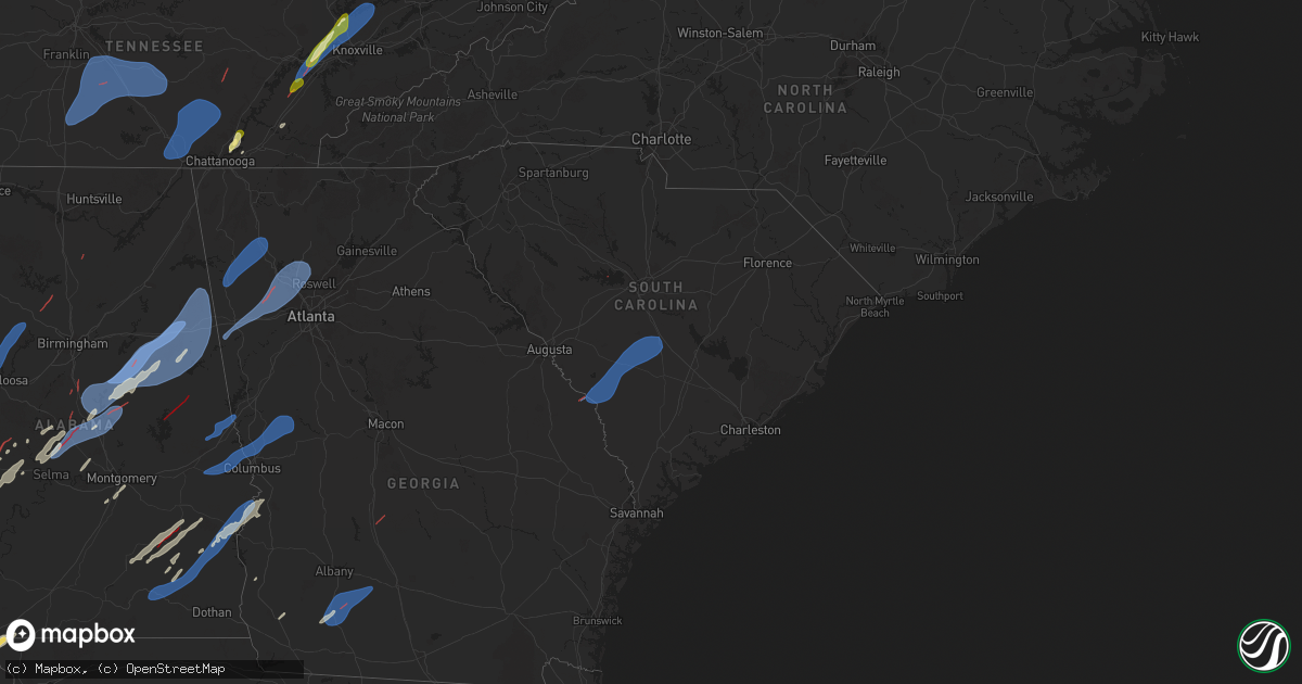
Hail Map in South Carolina on March 15, 2025
Get this storm
March 15 map
$229
one time, instant access
Download today. No call, no setup
Keep the $229
Bought the map and want the full workflow? Apply the entire $229 to a subscription within 7 days. None of it is wasted.
Every map, not just this one
This buys you this map. Subscription and you get every map we run, in the markets you choose from a few cities to whole states to nationwide. Plus real-time alerts the moment a storm fires.
Contact data
Name, contact info, occupancy, even credit band for addresses in the footprint. You go from where it hit to who to call.
Become the source they trust
Unlimited branding weather history reports on demand. You already have the documented answer ready for the property owner, and you are the one who showed up with it.
Property data and RoofTrace estimates
Pull up any address you have got, its value and the exact code rules for that jurisdiction, straight from One Click Code. Then RoofTrace estimates the squares, pitch, and roof value, priced the way you price.
Storm reports in South Carolina
South Carolina
| Date | Description |
|---|---|
| 03/15/20256:48 AM CDT | Broadcast media sent multiple pictures of trees down near the intersection of old bush river rd and wessinger rd. They also noted a power crew was working on island trl |
| 03/15/20256:38 AM CDT | A national weather service storm survey team determined that a tornado formed over lake murray near dreher island at 7:38 am local time... Causing high end ef-0 to low |
| 03/15/20256:29 AM CDT | Highway patrol reported power lines down near the intersection of ira kinard road and blacksgate east. |
| 03/15/20256:10 AM CDT | Report from public via media of multiple trees down near fairway lane at sweetwater country club. Nws survey team will check for a possible tornado on monday. |
All States Impacted by Hail Map on March 15, 2025
Cities Impacted by Hail Map on March 15, 2025
- Choudrant, LA
- Ruston, LA
- Dubach, LA
- Farmerville, LA
- Bernice, LA
- Monticello, AR
- Marion, LA
- Cordova, TN
- Hernando, MS
- Dundee, MS
- Hughes, AR
- Mason, TN
- Crenshaw, MS
- Millington, TN
- Coldwater, MS
- Marion, AR
- Southaven, MS
- Nesbit, MS
- Germantown, TN
- Arlington, TN
- Senatobia, MS
- Memphis, TN
- Sledge, MS
- Lyon, MS
- Marianna, AR
- Eads, TN
- Clarksdale, MS
- Helena, AR
- Tunica, MS
- Proctor, AR
- Coahoma, MS
- Robinsonville, MS
- Walls, MS
- Collierville, TN
- Brickeys, AR
- Horn Lake, MS
- Lake Cormorant, MS
- Sarah, MS
- Olive Branch, MS
- Como, MS
- Marks, MS
- Sardis, MS
- Batesville, MS
- West Memphis, AR
- Bells, TN
- Brownsville, TN
- Stanton, TN
- Florien, LA
- Vincent, OH
- Dermott, AR
- Lake Village, AR
- Wiergate, TX
- Hemphill, TX
- Columbia, LA
- West Monroe, LA
- Tichnor, AR
- Fresno, OH
- Somerville, TN
- Portland, AR
- Parkdale, AR
- Monroe, LA
- Collinston, LA
- Oak Ridge, LA
- Drummonds, TN
- Atoka, TN
- Oakland, TN
- Munford, TN
- Brighton, TN
- Watson, AR
- Boyle, MS
- Snow Lake, AR
- Poplar Grove, AR
- Marvell, AR
- Holly Grove, AR
- Elaine, AR
- Humboldt, TN
- Hamburg, AR
- Montrose, AR
- Arkansas City, AR
- Rohwer, AR
- Benoit, MS
- Crossett, AR
- Quitman, LA
- Byhalia, MS
- Spearsville, LA
- Rosedale, MS
- Gunnison, MS
- Beulah, MS
- Shelby, MS
- Mound Bayou, MS
- Burlison, TN
- Covington, TN
- Clarendon, AR
- Dodson, LA
- Sikes, LA
- Campbellsburg, KY
- New Liberty, KY
- Sanders, KY
- Turners Station, KY
- Owenton, KY
- Worthville, KY
- Alligator, MS
- Chatham, LA
- Duncan, MS
- McGehee, AR
- Tillar, AR
- Eros, LA
- Crumrod, AR
- Mellwood, AR
- Many, LA
- Fisher, LA
- Fountain Hill, AR
- Saulsbury, TN
- Grand Junction, TN
- Holly Springs, MS
- Cleveland, MS
- Merigold, MS
- Jonesboro, LA
- Harrisville, WV
- Cairo, WV
- Ripley, TN
- Henning, TN
- Osceola, AR
- Rayville, LA
- Mangham, LA
- Greenville, MS
- Trenton, TN
- Hornsby, TN
- Henderson, TN
- Bolivar, TN
- Bastrop, LA
- Sterlington, LA
- Little Hocking, OH
- Washington, WV
- Robeline, LA
- Provencal, LA
- Walker, WV
- Petroleum, WV
- Gleason, TN
- Paris, TN
- Pennsboro, WV
- Gates, TN
- Atlanta, LA
- Winnfield, LA
- Alamo, TN
- Melrose, LA
- Natchez, LA
- Pioneer, LA
- Natchitoches, LA
- Montgomery, LA
- Epps, LA
- Shaw, MS
- Halls, TN
- Friendship, TN
- Lake Providence, LA
- Oak Grove, LA
- Transylvania, LA
- Indianola, MS
- Mayersville, MS
- Montgomery, IN
- Cannelburg, IN
- Otwell, IN
- Jasper, IN
- Ruleville, MS
- Doddsville, MS
- Goldonna, LA
- Rolling Fork, MS
- Glen Allan, MS
- Hollandale, MS
- Chatham, MS
- Minter City, MS
- Anguilla, MS
- Loogootee, IN
- Bardwell, KY
- Philipp, MS
- Winnsboro, LA
- Fort Necessity, LA
- Schlater, MS
- Greenwood, MS
- Charleston, MS
- Belzoni, MS
- Tallulah, LA
- Holcomb, MS
- Scobey, MS
- Cascilla, MS
- Tillatoba, MS
- Melber, KY
- Cunningham, KY
- Isola, MS
- Oakland, MS
- Pope, MS
- Courtland, MS
- Water Valley, MS
- Inverness, MS
- Itta Bena, MS
- Sidon, MS
- Moorhead, MS
- Oxford, MS
- Taylor, MS
- Tchula, MS
- Carrollton, MS
- Cruger, MS
- Yazoo City, MS
- Lexington, MS
- Kentwood, LA
- Coila, MS
- Winona, MS
- McCarley, MS
- Durant, MS
- Duck Hill, MS
- Grenada, MS
- West, MS
- Vaiden, MS
- North Carrollton, MS
- Houston, MS
- Houlka, MS
- Osyka, MS
- Magnolia, MS
- Mccomb, MS
- Okolona, MS
- Tylertown, MS
- Eupora, MS
- Gore Springs, MS
- Stewart, MS
- Kilmichael, MS
- Calhoun City, MS
- Kokomo, MS
- Jayess, MS
- Foxworth, MS
- Bellefontaine, MS
- Woodland, MS
- Vardaman, MS
- Walthall, MS
- Mantee, MS
- Columbia, MS
- Sondheimer, LA
- Vicksburg, MS
- Saint Francisville, LA
- Woodville, MS
- Centreville, MS
- Norwood, LA
- Oak Vale, MS
- Carson, MS
- Aberdeen, MS
- Maben, MS
- Mathiston, MS
- Prentiss, MS
- Bassfield, MS
- Olla, LA
- Tullos, LA
- Jackson, LA
- Raleigh, MS
- Brookhaven, MS
- Livonia, LA
- Fordoche, LA
- Oscar, LA
- Lottie, LA
- Pride, LA
- Clinton, LA
- Slaughter, LA
- Gloster, MS
- Kelly, LA
- Collins, MS
- Tremont, MS
- Vina, AL
- Newton, MS
- Decatur, MS
- Lawrence, MS
- Zachary, LA
- Lake, MS
- Benton, MS
- Grayson, LA
- New Roads, LA
- Ventress, LA
- Jarreau, LA
- Greensburg, LA
- Mize, MS
- Red Bay, AL
- Russellville, AL
- Spruce Pine, AL
- Hodges, AL
- Plantersville, MS
- Tupelo, MS
- Nettleton, MS
- Golden, MS
- Vaughan, MS
- Ethel, LA
- Meadville, MS
- Shannon, MS
- Pontotoc, MS
- Pickens, MS
- Wesson, MS
- Greenwell Springs, LA
- Liberty, MS
- Mount Olive, MS
- McCall Creek, MS
- Taylorsville, MS
- Tuscumbia, AL
- Fulton, MS
- Sontag, MS
- Canton, MS
- Bentonia, MS
- Delhi, LA
- Verona, MS
- Forest, MS
- Little Rock, MS
- Amory, MS
- Pinola, MS
- Muscle Shoals, AL
- Goodman, MS
- Thaxton, MS
- De Kalb, MS
- Daleville, MS
- Summit, MS
- Braxton, MS
- Walker, LA
- Denham Springs, LA
- Pine Grove, LA
- Mooreville, MS
- Mantachie, MS
- Cherokee, AL
- Leighton, AL
- Sallis, MS
- Madison, MS
- Sheffield, AL
- Scooba, MS
- Porterville, MS
- Florence, AL
- Vernon, AL
- Aliceville, AL
- Emelle, AL
- Leland, MS
- Eutaw, AL
- Macon, MS
- Carrollton, AL
- Gordo, AL
- Roseland, LA
- Belden, MS
- Amite, LA
- Camden, MS
- Boligee, AL
- Ralph, AL
- Knoxville, AL
- Buhl, AL
- Fluker, LA
- Bay Springs, MS
- Mount Hermon, LA
- Elrod, AL
- Franklinton, LA
- Echola, AL
- Northport, AL
- Coker, AL
- Morenci, MI
- Clayton, MI
- Sand Creek, MI
- Adrian, MI
- Palmyra, MI
- Berry, AL
- Tuscaloosa, AL
- Iron City, TN
- Westpoint, TN
- Husser, LA
- Clinton, MI
- Tecumseh, MI
- Britton, MI
- Saline, MI
- Oakman, AL
- Loranger, LA
- Mendenhall, MS
- Rose Hill, MS
- Pachuta, MS
- Prairie, MS
- Ann Arbor, MI
- Ypsilanti, MI
- Milan, MI
- Plymouth, MI
- South Lyon, MI
- Northville, MI
- New Hudson, MI
- Milford, MI
- Wixom, MI
- Novi, MI
- Canton, MI
- Parrish, AL
- Hahnville, LA
- Reform, AL
- Commerce Township, MI
- Walled Lake, MI
- White Lake, MI
- West Bloomfield, MI
- Saint Rose, LA
- Kenner, LA
- Fayette, AL
- Meridian, MS
- Metairie, LA
- Ponchatoula, LA
- Cullman, AL
- Norco, LA
- Destrehan, LA
- Luling, LA
- Lacombe, LA
- Pikeville, TN
- Spencer, TN
- Cordova, AL
- Jasper, AL
- Empire, AL
- Bremen, AL
- Harrison, TN
- Ooltewah, TN
- Pearl River, LA
- Slidell, LA
- Hixson, TN
- Soddy Daisy, TN
- Stennis Space Center, MS
- Ellisville, MS
- Ovett, MS
- Chattanooga, TN
- Laurel, MS
- Smithville, MS
- Demopolis, AL
- Linden, AL
- Greenwood Springs, MS
- Hamilton, AL
- Diberville, MS
- Biloxi, MS
- Vancleave, MS
- Richton, MS
- Waynesboro, MS
- State Line, MS
- Gallion, AL
- Millport, AL
- Ethelsville, AL
- Lucedale, MS
- Niota, TN
- Sweetwater, TN
- Philadelphia, TN
- Loudon, TN
- Marion, AL
- Wilmer, AL
- Citronelle, AL
- Chunchula, AL
- Kingston, TN
- Oak Ridge, TN
- Pass Christian, MS
- Bay Saint Louis, MS
- Waveland, MS
- Newbern, AL
- Lenoir City, TN
- Faunsdale, AL
- Harriman, TN
- Oliver Springs, TN
- Clinton, TN
- Rocky Top, TN
- Andersonville, TN
- Norris, TN
- Heiskell, TN
- Sunflower, AL
- Wagarville, AL
- Centreville, AL
- Lawley, AL
- Calera, AL
- Montevallo, AL
- Thomaston, AL
- Magnolia, AL
- Grove Hill, AL
- Whatley, AL
- Leroy, AL
- Jackson, AL
- McIntosh, AL
- Deer Park, AL
- Uniontown, AL
- Catherine, AL
- Safford, AL
- Marion Junction, AL
- Talladega, AL
- Riceville, TN
- Moss Point, MS
- Clanton, AL
- Selma, AL
- Plantersville, AL
- Sylacauga, AL
- Goodwater, AL
- Maplesville, AL
- Stanton, AL
- Jemison, AL
- Columbiana, AL
- Shelby, AL
- Childersburg, AL
- Alpine, AL
- Munford, AL
- Oxford, AL
- Anniston, AL
- Lineville, AL
- Ashland, AL
- Delta, AL
- Heflin, AL
- Millerville, AL
- Weogufka, AL
- Jones, AL
- Billingsley, AL
- Marbury, AL
- Verbena, AL
- Rockford, AL
- Autaugaville, AL
- Prattville, AL
- Mobile, AL
- Irvington, AL
- Theodore, AL
- Piedmont, AL
- Jacksonville, AL
- Fruithurst, AL
- Woodland, AL
- Wedowee, AL
- Daphne, AL
- Bay Minette, AL
- Stapleton, AL
- Ranburne, AL
- Muscadine, AL
- McDavid, FL
- Century, FL
- Atmore, AL
- Brantley, AL
- Luverne, AL
- Jacksons Gap, AL
- Dadeville, AL
- Hope Hull, AL
- Montgomery, AL
- Troy, AL
- Glenwood, AL
- Goshen, AL
- Banks, AL
- Sugarcreek, OH
- Baltic, OH
- Stone Creek, OH
- New Philadelphia, OH
- Brundidge, AL
- Union Springs, AL
- Midway, AL
- Clayton, AL
- Louisville, AL
- Ozark, AL
- Enterprise, AL
- Ariton, AL
- Jack, AL
- Eufaula, AL
- Lumpkin, GA
- Omaha, GA
- Bradford, TN
- Greenfield, TN
- Chipley, FL
- Blakely, GA
- Paducah, KY
- Colquitt, GA
- Coshocton, OH
- Camilla, GA
- Cordele, GA
- Pelham, GA
- Vienna, GA
- Sale City, GA
- Cornersville, TN
- Culleoka, TN
- Lewisburg, TN
- Lynnville, TN
- Belfast, TN
- Shelbyville, TN
- Petersburg, TN
- Unionville, TN
- Chapel Hill, TN
- Arrington, TN
- College Grove, TN
- Eagleville, TN
- Rockvale, TN
- Bell Buckle, TN
- Christiana, TN
- Murfreesboro, TN
- Smyrna, TN
- Wartrace, TN
- Manchester, TN
- Bradyville, TN
- Beechgrove, TN
- Readyville, TN
- Morrison, TN
- Woodbury, TN
- Mcminnville, TN
- South Pittsburg, TN
- Sewanee, TN
- Monteagle, TN
- Tracy City, TN
- Sequatchie, TN
- Jasper, TN
- Whitwell, TN
- Palmer, TN
- Coalmont, TN
- Gruetli Laager, TN
- Altamont, TN
- Beersheba Springs, TN
- Dunlap, TN
- Knoxville, TN
- Powell, TN
- Sharps Chapel, TN
- Maynardville, TN
- Corryton, TN
- Luttrell, TN
- Pheba, MS
- Cedarbluff, MS
- West Point, MS
- Seminary, MS
- Sumrall, MS
- Enterprise, MS
- Hattiesburg, MS
- Purvis, MS
- Daviston, AL
- Auburn, AL
- Opelika, AL
- Hurtsboro, AL
- Salem, AL
- Phenix City, AL
- Smiths Station, AL
- Columbus, GA
- Fortson, GA
- Cataula, GA
- Hamilton, GA
- Pine Mountain Valley, GA
- Warm Springs, GA
- Shiloh, GA
- Pine Mountain, GA
- Manchester, GA
- Waverly Hall, GA
- Woodland, GA
- Ellerslie, GA
- Lafayette, AL
- Cusseta, AL
- Lanett, AL
- Valley, AL
- West Point, GA
- Lagrange, GA
- Dallas, GA
- Bowdon, GA
- Carrollton, GA
- Waco, GA
- Bremen, GA
- Temple, GA
- Villa Rica, GA
- Powder Springs, GA
- Douglasville, GA
- Hiram, GA
- Kennesaw, GA
- Acworth, GA
- Marietta, GA
- Woodstock, GA
- Canton, GA
- Cartersville, GA
- Austell, GA
- Roswell, GA
- Cedartown, GA
- Silver Creek, GA
- Rome, GA
- Lindale, GA
- Cave Spring, GA
- Aragon, GA
- Taylorsville, GA
- Kingston, GA
- Adairsville, GA
- Elba, AL
- New Brockton, AL
- Fort Rucker, AL
- Skipperville, AL
- Clio, AL
- Clopton, AL
- Pittsview, AL
- Meigs, GA
- Baconton, GA
- Albany, GA
- Doerun, GA
- Sylvester, GA
- Hartsfield, GA
- Sumner, GA
- Girard, GA
- Martin, SC
- Sylvania, GA
- Barnwell, SC
- Allendale, SC
- Ulmer, SC
- Olar, SC
- Blackville, SC
- Williston, SC
- Denmark, SC
- Norway, SC
- Cope, SC
- Bamberg, SC
- Cordova, SC
- Orangeburg, SC
- Neeses, SC
- Chapin, SC


