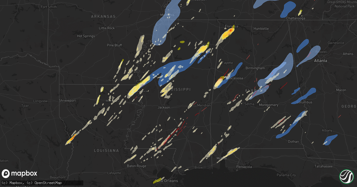
Hail Map in Mississippi on March 15, 2025
Get this storm
March 15 map
$229
one time, instant access
Download today. No call, no setup
Keep the $229
Bought the map and want the full workflow? Apply the entire $229 to a subscription within 7 days. None of it is wasted.
Every map, not just this one
This buys you this map. Subscription and you get every map we run, in the markets you choose from a few cities to whole states to nationwide. Plus real-time alerts the moment a storm fires.
Contact data
Name, contact info, occupancy, even credit band for addresses in the footprint. You go from where it hit to who to call.
Become the source they trust
Unlimited branding weather history reports on demand. You already have the documented answer ready for the property owner, and you are the one who showed up with it.
Property data and RoofTrace estimates
Pull up any address you have got, its value and the exact code rules for that jurisdiction, straight from One Click Code. Then RoofTrace estimates the squares, pitch, and roof value, priced the way you price.
Storm reports in Mississippi
Mississippi
| Date | Description |
|---|---|
| 03/15/20254:43 PM CDT | Trees down along hwy 45. |
| 03/15/20254:18 PM CDT | Trees and power lines downed on the north end of lake eddins. Trees down on multiple houses... A garage destroyed... And a boat house destroyed. |
| 03/15/20254:13 PM CDT | Reports of multiple power flashes on 192 watts rd. Possible tornado. |
| 03/15/20254:11 PM CDT | Trees downed on cr 16. |
| 03/15/20253:20 PM CDT | Tds and multiple structures damaged at and near hwy 49. |
| 03/15/20253:12 PM CDT | Report of extensive tree damage and downed trees blocking hwy-531. |
| 03/15/20253:08 PM CDT | Large tds... Damage reported by em. |
| 03/15/20253:04 PM CDT | Damage reported along bethel church rd. |
| 03/15/20252:55 PM CDT | Corrects previous tornado report from 4 sw bay springs. Report of extensive tree damage and downed trees blocking hwy-531. |
| 03/15/20252:38 PM CDT | Path of trees downed crossing cr 23. |
| 03/15/20252:27 PM CDT | Local law enforcement reported multiple trees and powerlines down on new salem rd. |
| 03/15/20252:24 PM CDT | A local report indicates 58 MPH wind near 4 SE Hattiesburg |
| 03/15/20252:20 PM CDT | Large tds... Damage reported by em. |
| 03/15/20252:16 PM CDT | Tds. |
| 03/15/20252:10 PM CDT | Pictures posted of swath of trees snapped with some uprooted... Damage to metal structure and damage to tractor trailers. |
| 03/15/20252:05 PM CDT | Report of extensive tree damage along hwy-37 and damage to the roof of a structure. |
| 03/15/20252:05 PM CDT | Report of extensive tree damage along hwy-37 and damage to the roof of a structure. |
| 03/15/20252:05 PM CDT | Reported golf ball sized hail in shannon area of lee county. |
| 03/15/20251:58 PM CDT | Tornado observed west of hot coffee. |
| 03/15/20251:54 PM CDT | Law enforcement reported multiple trees down near hwy 472 along with marble size hail. |
| 03/15/20251:45 PM CDT | Tds... Damage reported by em. |
| 03/15/20251:44 PM CDT | Trees and powerlines downed at ms 503 and ac thompson rd. |
| 03/15/20251:39 PM CDT | Tds... Damage reported by em. |
| 03/15/20251:34 PM CDT | A stand of trees snapped along the natchez trace parkway near the van vleet community. Possible tornado. |
| 03/15/20251:31 PM CDT | Large tds... Damage reported by em. |
| 03/15/20251:31 PM CDT | Delayed report - multiple trees down and power outages in the houston area. Time estimated via radar. |
| 03/15/20251:25 PM CDT | Extensive damage; likely tornado. |
| 03/15/20251:23 PM CDT | Large tds... Damage reported by em. |
| 03/15/20251:22 PM CDT | Law enforcement reported a tree down on loring rd. Both lanes of traffic are blocked. |
| 03/15/20251:16 PM CDT | Tds at hwy 13... Damage reported by em. |
| 03/15/20251:15 PM CDT | Delayed report - tree trunks snapped along highway 371 north of bigbee. |
| 03/15/20251:12 PM CDT | Large tree on home on parkview st. |
| 03/15/20251:04 PM CDT | Large tds... Also damage reported from em. |
| 03/15/202512:55 PM CDT | Damage to sheds... Outbuildings and trees. Likely tornado. Time estimated. |
| 03/15/202512:53 PM CDT | Local law enforcement reported several trees down near collier cv in rankin ms. |
| 03/15/202512:42 PM CDT | Damage to a trailer park; likely tornado. |
| 03/15/202511:22 AM CDT | A local report indicates 1.00 inch wind near 4 ENE Taylor |
| 03/15/202511:21 AM CDT | Farm shop destroyed... Several houses destroyed south of grace on hwy 1. Sharkey ema reporting injuries with ambulances on the way to grace area in issaquena co. Via wa |
| 03/15/202511:21 AM CDT | Corrects previous tstm wnd gst report from grace. Farm shop destroyed... Several houses destroyed south of grace on hwy 1. Sharkey ema reporting injuries with ambulance |
| 03/15/202511:20 AM CDT | Several homes destroyed on bear pen and in the hopedale road area. Power lines across highway 1 south of grace. Sharkey county em natalie perkins. |
| 03/15/202511:10 AM CDT | Quarter size hail reported on county road 220. |
| 03/15/202510:40 AM CDT | Utility pole snapped and trees snapped along us 61 just south of nitta yuma. |
| 03/15/202510:28 AM CDT | Sharkey county ema reports houses damaged and power lines down near grace with an ambulance in route for possible injuries. |
| 03/15/202510:09 AM CDT | Law enforcement reported a tree down on a powerline near 101 dorrough rd in ruleville. |
| 03/15/20258:18 AM CDT | A local report indicates 58 MPH wind near 1 WSW Valley Hill |
| 03/15/20258:01 AM CDT | A local report indicates 62 MPH wind near 2 E Tunica |
All States Impacted by Hail Map on March 15, 2025
Cities Impacted by Hail Map on March 15, 2025
- Choudrant, LA
- Ruston, LA
- Dubach, LA
- Farmerville, LA
- Bernice, LA
- Monticello, AR
- Marion, LA
- Cordova, TN
- Hernando, MS
- Dundee, MS
- Hughes, AR
- Mason, TN
- Crenshaw, MS
- Millington, TN
- Coldwater, MS
- Marion, AR
- Southaven, MS
- Nesbit, MS
- Germantown, TN
- Arlington, TN
- Senatobia, MS
- Memphis, TN
- Sledge, MS
- Lyon, MS
- Marianna, AR
- Eads, TN
- Clarksdale, MS
- Helena, AR
- Tunica, MS
- Proctor, AR
- Coahoma, MS
- Robinsonville, MS
- Walls, MS
- Collierville, TN
- Brickeys, AR
- Horn Lake, MS
- Lake Cormorant, MS
- Sarah, MS
- Olive Branch, MS
- Como, MS
- Marks, MS
- Sardis, MS
- Batesville, MS
- West Memphis, AR
- Bells, TN
- Brownsville, TN
- Stanton, TN
- Florien, LA
- Vincent, OH
- Dermott, AR
- Lake Village, AR
- Wiergate, TX
- Hemphill, TX
- Columbia, LA
- West Monroe, LA
- Tichnor, AR
- Fresno, OH
- Somerville, TN
- Portland, AR
- Parkdale, AR
- Monroe, LA
- Collinston, LA
- Oak Ridge, LA
- Drummonds, TN
- Atoka, TN
- Oakland, TN
- Munford, TN
- Brighton, TN
- Watson, AR
- Boyle, MS
- Snow Lake, AR
- Poplar Grove, AR
- Marvell, AR
- Holly Grove, AR
- Elaine, AR
- Humboldt, TN
- Hamburg, AR
- Montrose, AR
- Arkansas City, AR
- Rohwer, AR
- Benoit, MS
- Crossett, AR
- Quitman, LA
- Byhalia, MS
- Spearsville, LA
- Rosedale, MS
- Gunnison, MS
- Beulah, MS
- Shelby, MS
- Mound Bayou, MS
- Burlison, TN
- Covington, TN
- Clarendon, AR
- Dodson, LA
- Sikes, LA
- Campbellsburg, KY
- New Liberty, KY
- Sanders, KY
- Turners Station, KY
- Owenton, KY
- Worthville, KY
- Alligator, MS
- Chatham, LA
- Duncan, MS
- McGehee, AR
- Tillar, AR
- Eros, LA
- Crumrod, AR
- Mellwood, AR
- Many, LA
- Fisher, LA
- Fountain Hill, AR
- Saulsbury, TN
- Grand Junction, TN
- Holly Springs, MS
- Cleveland, MS
- Merigold, MS
- Jonesboro, LA
- Harrisville, WV
- Cairo, WV
- Ripley, TN
- Henning, TN
- Osceola, AR
- Rayville, LA
- Mangham, LA
- Greenville, MS
- Trenton, TN
- Hornsby, TN
- Henderson, TN
- Bolivar, TN
- Bastrop, LA
- Sterlington, LA
- Little Hocking, OH
- Washington, WV
- Robeline, LA
- Provencal, LA
- Walker, WV
- Petroleum, WV
- Gleason, TN
- Paris, TN
- Pennsboro, WV
- Gates, TN
- Atlanta, LA
- Winnfield, LA
- Alamo, TN
- Melrose, LA
- Natchez, LA
- Pioneer, LA
- Natchitoches, LA
- Montgomery, LA
- Epps, LA
- Shaw, MS
- Halls, TN
- Friendship, TN
- Lake Providence, LA
- Oak Grove, LA
- Transylvania, LA
- Indianola, MS
- Mayersville, MS
- Montgomery, IN
- Cannelburg, IN
- Otwell, IN
- Jasper, IN
- Ruleville, MS
- Doddsville, MS
- Goldonna, LA
- Rolling Fork, MS
- Glen Allan, MS
- Hollandale, MS
- Chatham, MS
- Minter City, MS
- Anguilla, MS
- Loogootee, IN
- Bardwell, KY
- Philipp, MS
- Winnsboro, LA
- Fort Necessity, LA
- Schlater, MS
- Greenwood, MS
- Charleston, MS
- Belzoni, MS
- Tallulah, LA
- Holcomb, MS
- Scobey, MS
- Cascilla, MS
- Tillatoba, MS
- Melber, KY
- Cunningham, KY
- Isola, MS
- Oakland, MS
- Pope, MS
- Courtland, MS
- Water Valley, MS
- Inverness, MS
- Itta Bena, MS
- Sidon, MS
- Moorhead, MS
- Oxford, MS
- Taylor, MS
- Tchula, MS
- Carrollton, MS
- Cruger, MS
- Yazoo City, MS
- Lexington, MS
- Kentwood, LA
- Coila, MS
- Winona, MS
- McCarley, MS
- Durant, MS
- Duck Hill, MS
- Grenada, MS
- West, MS
- Vaiden, MS
- North Carrollton, MS
- Houston, MS
- Houlka, MS
- Osyka, MS
- Magnolia, MS
- Mccomb, MS
- Okolona, MS
- Tylertown, MS
- Eupora, MS
- Gore Springs, MS
- Stewart, MS
- Kilmichael, MS
- Calhoun City, MS
- Kokomo, MS
- Jayess, MS
- Foxworth, MS
- Bellefontaine, MS
- Woodland, MS
- Vardaman, MS
- Walthall, MS
- Mantee, MS
- Columbia, MS
- Sondheimer, LA
- Vicksburg, MS
- Saint Francisville, LA
- Woodville, MS
- Centreville, MS
- Norwood, LA
- Oak Vale, MS
- Carson, MS
- Aberdeen, MS
- Maben, MS
- Mathiston, MS
- Prentiss, MS
- Bassfield, MS
- Olla, LA
- Tullos, LA
- Jackson, LA
- Raleigh, MS
- Brookhaven, MS
- Livonia, LA
- Fordoche, LA
- Oscar, LA
- Lottie, LA
- Pride, LA
- Clinton, LA
- Slaughter, LA
- Gloster, MS
- Kelly, LA
- Collins, MS
- Tremont, MS
- Vina, AL
- Newton, MS
- Decatur, MS
- Lawrence, MS
- Zachary, LA
- Lake, MS
- Benton, MS
- Grayson, LA
- New Roads, LA
- Ventress, LA
- Jarreau, LA
- Greensburg, LA
- Mize, MS
- Red Bay, AL
- Russellville, AL
- Spruce Pine, AL
- Hodges, AL
- Plantersville, MS
- Tupelo, MS
- Nettleton, MS
- Golden, MS
- Vaughan, MS
- Ethel, LA
- Meadville, MS
- Shannon, MS
- Pontotoc, MS
- Pickens, MS
- Wesson, MS
- Greenwell Springs, LA
- Liberty, MS
- Mount Olive, MS
- McCall Creek, MS
- Taylorsville, MS
- Tuscumbia, AL
- Fulton, MS
- Sontag, MS
- Canton, MS
- Bentonia, MS
- Delhi, LA
- Verona, MS
- Forest, MS
- Little Rock, MS
- Amory, MS
- Pinola, MS
- Muscle Shoals, AL
- Goodman, MS
- Thaxton, MS
- De Kalb, MS
- Daleville, MS
- Summit, MS
- Braxton, MS
- Walker, LA
- Denham Springs, LA
- Pine Grove, LA
- Mooreville, MS
- Mantachie, MS
- Cherokee, AL
- Leighton, AL
- Sallis, MS
- Madison, MS
- Sheffield, AL
- Scooba, MS
- Porterville, MS
- Florence, AL
- Vernon, AL
- Aliceville, AL
- Emelle, AL
- Leland, MS
- Eutaw, AL
- Macon, MS
- Carrollton, AL
- Gordo, AL
- Roseland, LA
- Belden, MS
- Amite, LA
- Camden, MS
- Boligee, AL
- Ralph, AL
- Knoxville, AL
- Buhl, AL
- Fluker, LA
- Bay Springs, MS
- Mount Hermon, LA
- Elrod, AL
- Franklinton, LA
- Echola, AL
- Northport, AL
- Coker, AL
- Morenci, MI
- Clayton, MI
- Sand Creek, MI
- Adrian, MI
- Palmyra, MI
- Berry, AL
- Tuscaloosa, AL
- Iron City, TN
- Westpoint, TN
- Husser, LA
- Clinton, MI
- Tecumseh, MI
- Britton, MI
- Saline, MI
- Oakman, AL
- Loranger, LA
- Mendenhall, MS
- Rose Hill, MS
- Pachuta, MS
- Prairie, MS
- Ann Arbor, MI
- Ypsilanti, MI
- Milan, MI
- Plymouth, MI
- South Lyon, MI
- Northville, MI
- New Hudson, MI
- Milford, MI
- Wixom, MI
- Novi, MI
- Canton, MI
- Parrish, AL
- Hahnville, LA
- Reform, AL
- Commerce Township, MI
- Walled Lake, MI
- White Lake, MI
- West Bloomfield, MI
- Saint Rose, LA
- Kenner, LA
- Fayette, AL
- Meridian, MS
- Metairie, LA
- Ponchatoula, LA
- Cullman, AL
- Norco, LA
- Destrehan, LA
- Luling, LA
- Lacombe, LA
- Pikeville, TN
- Spencer, TN
- Cordova, AL
- Jasper, AL
- Empire, AL
- Bremen, AL
- Harrison, TN
- Ooltewah, TN
- Pearl River, LA
- Slidell, LA
- Hixson, TN
- Soddy Daisy, TN
- Stennis Space Center, MS
- Ellisville, MS
- Ovett, MS
- Chattanooga, TN
- Laurel, MS
- Smithville, MS
- Demopolis, AL
- Linden, AL
- Greenwood Springs, MS
- Hamilton, AL
- Diberville, MS
- Biloxi, MS
- Vancleave, MS
- Richton, MS
- Waynesboro, MS
- State Line, MS
- Gallion, AL
- Millport, AL
- Ethelsville, AL
- Lucedale, MS
- Niota, TN
- Sweetwater, TN
- Philadelphia, TN
- Loudon, TN
- Marion, AL
- Wilmer, AL
- Citronelle, AL
- Chunchula, AL
- Kingston, TN
- Oak Ridge, TN
- Pass Christian, MS
- Bay Saint Louis, MS
- Waveland, MS
- Newbern, AL
- Lenoir City, TN
- Faunsdale, AL
- Harriman, TN
- Oliver Springs, TN
- Clinton, TN
- Rocky Top, TN
- Andersonville, TN
- Norris, TN
- Heiskell, TN
- Sunflower, AL
- Wagarville, AL
- Centreville, AL
- Lawley, AL
- Calera, AL
- Montevallo, AL
- Thomaston, AL
- Magnolia, AL
- Grove Hill, AL
- Whatley, AL
- Leroy, AL
- Jackson, AL
- McIntosh, AL
- Deer Park, AL
- Uniontown, AL
- Catherine, AL
- Safford, AL
- Marion Junction, AL
- Talladega, AL
- Riceville, TN
- Moss Point, MS
- Clanton, AL
- Selma, AL
- Plantersville, AL
- Sylacauga, AL
- Goodwater, AL
- Maplesville, AL
- Stanton, AL
- Jemison, AL
- Columbiana, AL
- Shelby, AL
- Childersburg, AL
- Alpine, AL
- Munford, AL
- Oxford, AL
- Anniston, AL
- Lineville, AL
- Ashland, AL
- Delta, AL
- Heflin, AL
- Millerville, AL
- Weogufka, AL
- Jones, AL
- Billingsley, AL
- Marbury, AL
- Verbena, AL
- Rockford, AL
- Autaugaville, AL
- Prattville, AL
- Mobile, AL
- Irvington, AL
- Theodore, AL
- Piedmont, AL
- Jacksonville, AL
- Fruithurst, AL
- Woodland, AL
- Wedowee, AL
- Daphne, AL
- Bay Minette, AL
- Stapleton, AL
- Ranburne, AL
- Muscadine, AL
- McDavid, FL
- Century, FL
- Atmore, AL
- Brantley, AL
- Luverne, AL
- Jacksons Gap, AL
- Dadeville, AL
- Hope Hull, AL
- Montgomery, AL
- Troy, AL
- Glenwood, AL
- Goshen, AL
- Banks, AL
- Sugarcreek, OH
- Baltic, OH
- Stone Creek, OH
- New Philadelphia, OH
- Brundidge, AL
- Union Springs, AL
- Midway, AL
- Clayton, AL
- Louisville, AL
- Ozark, AL
- Enterprise, AL
- Ariton, AL
- Jack, AL
- Eufaula, AL
- Lumpkin, GA
- Omaha, GA
- Bradford, TN
- Greenfield, TN
- Chipley, FL
- Blakely, GA
- Paducah, KY
- Colquitt, GA
- Coshocton, OH
- Camilla, GA
- Cordele, GA
- Pelham, GA
- Vienna, GA
- Sale City, GA
- Cornersville, TN
- Culleoka, TN
- Lewisburg, TN
- Lynnville, TN
- Belfast, TN
- Shelbyville, TN
- Petersburg, TN
- Unionville, TN
- Chapel Hill, TN
- Arrington, TN
- College Grove, TN
- Eagleville, TN
- Rockvale, TN
- Bell Buckle, TN
- Christiana, TN
- Murfreesboro, TN
- Smyrna, TN
- Wartrace, TN
- Manchester, TN
- Bradyville, TN
- Beechgrove, TN
- Readyville, TN
- Morrison, TN
- Woodbury, TN
- Mcminnville, TN
- South Pittsburg, TN
- Sewanee, TN
- Monteagle, TN
- Tracy City, TN
- Sequatchie, TN
- Jasper, TN
- Whitwell, TN
- Palmer, TN
- Coalmont, TN
- Gruetli Laager, TN
- Altamont, TN
- Beersheba Springs, TN
- Dunlap, TN
- Knoxville, TN
- Powell, TN
- Sharps Chapel, TN
- Maynardville, TN
- Corryton, TN
- Luttrell, TN
- Pheba, MS
- Cedarbluff, MS
- West Point, MS
- Seminary, MS
- Sumrall, MS
- Enterprise, MS
- Hattiesburg, MS
- Purvis, MS
- Daviston, AL
- Auburn, AL
- Opelika, AL
- Hurtsboro, AL
- Salem, AL
- Phenix City, AL
- Smiths Station, AL
- Columbus, GA
- Fortson, GA
- Cataula, GA
- Hamilton, GA
- Pine Mountain Valley, GA
- Warm Springs, GA
- Shiloh, GA
- Pine Mountain, GA
- Manchester, GA
- Waverly Hall, GA
- Woodland, GA
- Ellerslie, GA
- Lafayette, AL
- Cusseta, AL
- Lanett, AL
- Valley, AL
- West Point, GA
- Lagrange, GA
- Dallas, GA
- Bowdon, GA
- Carrollton, GA
- Waco, GA
- Bremen, GA
- Temple, GA
- Villa Rica, GA
- Powder Springs, GA
- Douglasville, GA
- Hiram, GA
- Kennesaw, GA
- Acworth, GA
- Marietta, GA
- Woodstock, GA
- Canton, GA
- Cartersville, GA
- Austell, GA
- Roswell, GA
- Cedartown, GA
- Silver Creek, GA
- Rome, GA
- Lindale, GA
- Cave Spring, GA
- Aragon, GA
- Taylorsville, GA
- Kingston, GA
- Adairsville, GA
- Elba, AL
- New Brockton, AL
- Fort Rucker, AL
- Skipperville, AL
- Clio, AL
- Clopton, AL
- Pittsview, AL
- Meigs, GA
- Baconton, GA
- Albany, GA
- Doerun, GA
- Sylvester, GA
- Hartsfield, GA
- Sumner, GA
- Girard, GA
- Martin, SC
- Sylvania, GA
- Barnwell, SC
- Allendale, SC
- Ulmer, SC
- Olar, SC
- Blackville, SC
- Williston, SC
- Denmark, SC
- Norway, SC
- Cope, SC
- Bamberg, SC
- Cordova, SC
- Orangeburg, SC
- Neeses, SC
- Chapin, SC


