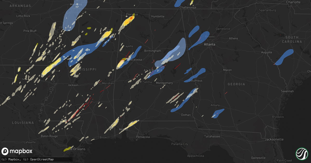
Hail Map in Alabama on March 15, 2025
Get this storm
March 15 map
$229
one time, instant access
Download today. No call, no setup
Keep the $229
Bought the map and want the full workflow? Apply the entire $229 to a subscription within 7 days. None of it is wasted.
Every map, not just this one
This buys you this map. Subscription and you get every map we run, in the markets you choose from a few cities to whole states to nationwide. Plus real-time alerts the moment a storm fires.
Contact data
Name, contact info, occupancy, even credit band for addresses in the footprint. You go from where it hit to who to call.
Become the source they trust
Unlimited branding weather history reports on demand. You already have the documented answer ready for the property owner, and you are the one who showed up with it.
Property data and RoofTrace estimates
Pull up any address you have got, its value and the exact code rules for that jurisdiction, straight from One Click Code. Then RoofTrace estimates the squares, pitch, and roof value, priced the way you price.
Storm reports in Alabama
Alabama
| Date | Description |
|---|---|
| 03/15/20256:52 PM CDT | Trees down blocking the road on al-61... And near cr-16... Both in and near newbern. Possible tornado. |
| 03/15/20256:44 PM CDT | Trees down on al-25 and cr-57... In the southern part of hale county. Possible tornado. |
| 03/15/20256:42 PM CDT | Report of a tree down at 6000 county rd 8 in woodville al from ema. |
| 03/15/20255:28 PM CDT | Seven to 10 large trees down... Blocking cr-13 near the alumuchee creek bridge. Possible tornado. Time estimated by radar. |
| 03/15/20254:52 PM CDT | Several houses with significant damage... And possible injuries... On campbellville road northeast of sipsey. Tds observed on radar at the time. |
| 03/15/20254:50 PM CDT | Fire department responding to numerous reports of trees down... Including some on houses... In sipsey. |
| 03/15/20254:45 PM CDT | Numerous trees snapped on us-82... Near the northwest city limits of gordo. |
| 03/15/20254:40 PM CDT | Trees down. Reported by 911 center. Possible tornado. |
| 03/15/20254:31 PM CDT | Trees down on paul bolton road. Possible tornado. |
| 03/15/20254:31 PM CDT | Trees down. Possible tornado. |
| 03/15/20254:23 PM CDT | Several large trees down on al-69... Just south of the tuscaloosa and walker county line. Possible tornado. |
| 03/15/20254:10 PM CDT | Tree downed in the 100 block of kentucky ave in sheffield. Time estimated from radar. |
| 03/15/20254:10 PM CDT | Trees and power lines down on al-69... Between buffalo ridge road and yell |
| 03/15/20254:10 PM CDT | Trees and power lines down on al-69... Between buffalo ridge road and yellow creek road. Lots of debris on the road. Possible tornado. |
| 03/15/20254:04 PM CDT | Tree down blocking highway 43. |
| 03/15/20254:02 PM CDT | Numerous reports of trees down around the samantha and lake tuscaloosa areas... Including tierce patton road. Possible tornado. |
| 03/15/20253:41 PM CDT | Numerous trees snapped. A few trees uprooted. At least one house with roof damage. Spotter saw the tornado cross us-82 near minas road. |
| 03/15/20252:45 PM CDT | Several trees uprooted. |
| 03/15/20252:45 PM CDT | Several trees down. |
| 03/15/20252:39 PM CDT | Emergency management reported quarter size hail one mile west of shoal creek on highway 72. |
| 03/15/20252:35 PM CDT | Estimated ping pong ball sized hail. |
| 03/15/20252:34 PM CDT | Social media report received for 1.25 inch hail. |
| 03/15/20252:30 PM CDT | Estimated 1 inch hail was reported in killen. |
| 03/15/20252:26 PM CDT | Emergency management reported baseball size hail in the colbert heights community. |
| 03/15/20252:20 PM CDT | Social media report received with photo of 2 inch hail. |
| 03/15/20252:20 PM CDT | Report of a tree down from 911 call center at the corner s blackwell rd and w wheeler ave. |
| 03/15/20252:20 PM CDT | Tree downed near the garage and cherokee roads intersection. Time estimated from radar. |
| 03/15/20252:20 PM CDT | Tree downed in the 900 block of north montgomery ave in sheffield. Time estimated by radar. |
| 03/15/20252:15 PM CDT | Report of a tree down from 911 call center at the corner of gusmus ave and louise ave. |
| 03/15/20252:13 PM CDT | Emergency management reported ping pong ball sized hail in new bethel alabama. |
| 03/15/202512:45 AM CDT | Several trees reported down across coffee county. |
| 03/15/202512:45 AM CDT | Several trees down on oak bowery and grand national. |
| 03/15/202512:15 AM CDT | Trees reported down across various parts of russell county. |
| 03/14/202511:52 PM CDT | Several trees down on oak bowery and grand national. Corrected for time based on radar. |
| 03/14/202511:15 PM CDT | Reports of trees down across upper river road in tallassee. |
| 03/14/202511:11 PM CDT | Downed trees. Damage to residences with one mh rolled and destroyed. Probable tornado. |
| 03/14/202511:02 PM CDT | Trees snapped and uprooted. Possible tornado. |
| 03/14/202511:02 PM CDT | Damage along highway 231 involving downed utility poles... Busted out business signs... Downed trees. Probable tornado. |
| 03/14/202510:49 PM CDT | Trees down involving a camper and shed. Possible tornado. |
| 03/14/20259:59 PM CDT | Trees down in the deatsville area. |
| 03/14/20259:57 PM CDT | Various reports of trees and powerlines down across northeastern autauga county. |
| 03/14/20259:28 PM CDT | Awos station kanb measured a gust of 77 mph. |
| 03/14/20259:22 PM CDT | Trees blown down in the oxford area... At least one onto a residence. |
| 03/14/20259:05 PM CDT | At le |
| 03/14/20259:05 PM CDT | At least 2 houses and one manufactured home received damage near the cr-15 and cr-16 area of chilton county. |
| 03/14/20259:02 PM CDT | Extensive damage reported reported on us-82 near maplesville. Tds observed on radar. |
| 03/14/20259:02 PM CDT | Damage to a metal roof of a home. Time estimated by radar. |
| 03/14/20258:56 PM CDT | Trees blown down in the vicinity of highway 77 and mountain view road. Time estimated from radar. |
| 03/14/20258:54 PM CDT | Extensive damage in plantersville. |
| 03/14/20258:53 PM CDT | Trees blown down on the southeast side of talladega. |
| 03/14/20258:53 PM CDT | Structural damage and trees down in the vicinity of lovelady drive and cr 63. Tds appeared on the following radar scan. |
| 03/14/20258:50 PM CDT | Trees blown down. |
| 03/14/20258:47 PM CDT | Trees down at cr 222 and hwy 22. Tds appeared on the following scan. |
| 03/14/20258:43 PM CDT | Damage reported at winterboro high school. |
| 03/14/20258:42 PM CDT | Tree on a house just off highway 21. No injuries. |
| 03/14/20258:33 PM CDT | Trees down in the sylacauga area. |
| 03/14/20258:32 PM CDT | Trees blown down. |
| 03/14/20258:21 PM CDT | Several trees down in the quail run area. |
| 03/14/20258:19 PM CDT | Several reports of damage near the i-65/us-31 intersection near calera... Including businesses and homes. |
| 03/14/20258:02 PM CDT | Extensive damage to a trailer park in the city of calera. Possible tornado. |
| 03/14/20258:00 PM CDT | An ef-1 tornado was confirmed by nws meteorologists... Affecting areas between montevallo and calera. |
| 03/14/20257:57 PM CDT | An ef-1 tornado was confirmed by nws meteorologists... Affecting the calera area. |
| 03/14/20257:39 PM CDT | An ef-0 tornado was confirmed by nws meteorologists... Affecting southeast bibb county near thomas mill. |
All States Impacted by Hail Map on March 15, 2025
Cities Impacted by Hail Map on March 15, 2025
- Choudrant, LA
- Ruston, LA
- Dubach, LA
- Farmerville, LA
- Bernice, LA
- Monticello, AR
- Marion, LA
- Cordova, TN
- Hernando, MS
- Dundee, MS
- Hughes, AR
- Mason, TN
- Crenshaw, MS
- Millington, TN
- Coldwater, MS
- Marion, AR
- Southaven, MS
- Nesbit, MS
- Germantown, TN
- Arlington, TN
- Senatobia, MS
- Memphis, TN
- Sledge, MS
- Lyon, MS
- Marianna, AR
- Eads, TN
- Clarksdale, MS
- Helena, AR
- Tunica, MS
- Proctor, AR
- Coahoma, MS
- Robinsonville, MS
- Walls, MS
- Collierville, TN
- Brickeys, AR
- Horn Lake, MS
- Lake Cormorant, MS
- Sarah, MS
- Olive Branch, MS
- Como, MS
- Marks, MS
- Sardis, MS
- Batesville, MS
- West Memphis, AR
- Bells, TN
- Brownsville, TN
- Stanton, TN
- Florien, LA
- Vincent, OH
- Dermott, AR
- Lake Village, AR
- Wiergate, TX
- Hemphill, TX
- Columbia, LA
- West Monroe, LA
- Tichnor, AR
- Fresno, OH
- Somerville, TN
- Portland, AR
- Parkdale, AR
- Monroe, LA
- Collinston, LA
- Oak Ridge, LA
- Drummonds, TN
- Atoka, TN
- Oakland, TN
- Munford, TN
- Brighton, TN
- Watson, AR
- Boyle, MS
- Snow Lake, AR
- Poplar Grove, AR
- Marvell, AR
- Holly Grove, AR
- Elaine, AR
- Humboldt, TN
- Hamburg, AR
- Montrose, AR
- Arkansas City, AR
- Rohwer, AR
- Benoit, MS
- Crossett, AR
- Quitman, LA
- Byhalia, MS
- Spearsville, LA
- Rosedale, MS
- Gunnison, MS
- Beulah, MS
- Shelby, MS
- Mound Bayou, MS
- Burlison, TN
- Covington, TN
- Clarendon, AR
- Dodson, LA
- Sikes, LA
- Campbellsburg, KY
- New Liberty, KY
- Sanders, KY
- Turners Station, KY
- Owenton, KY
- Worthville, KY
- Alligator, MS
- Chatham, LA
- Duncan, MS
- McGehee, AR
- Tillar, AR
- Eros, LA
- Crumrod, AR
- Mellwood, AR
- Many, LA
- Fisher, LA
- Fountain Hill, AR
- Saulsbury, TN
- Grand Junction, TN
- Holly Springs, MS
- Cleveland, MS
- Merigold, MS
- Jonesboro, LA
- Harrisville, WV
- Cairo, WV
- Ripley, TN
- Henning, TN
- Osceola, AR
- Rayville, LA
- Mangham, LA
- Greenville, MS
- Trenton, TN
- Hornsby, TN
- Henderson, TN
- Bolivar, TN
- Bastrop, LA
- Sterlington, LA
- Little Hocking, OH
- Washington, WV
- Robeline, LA
- Provencal, LA
- Walker, WV
- Petroleum, WV
- Gleason, TN
- Paris, TN
- Pennsboro, WV
- Gates, TN
- Atlanta, LA
- Winnfield, LA
- Alamo, TN
- Melrose, LA
- Natchez, LA
- Pioneer, LA
- Natchitoches, LA
- Montgomery, LA
- Epps, LA
- Shaw, MS
- Halls, TN
- Friendship, TN
- Lake Providence, LA
- Oak Grove, LA
- Transylvania, LA
- Indianola, MS
- Mayersville, MS
- Montgomery, IN
- Cannelburg, IN
- Otwell, IN
- Jasper, IN
- Ruleville, MS
- Doddsville, MS
- Goldonna, LA
- Rolling Fork, MS
- Glen Allan, MS
- Hollandale, MS
- Chatham, MS
- Minter City, MS
- Anguilla, MS
- Loogootee, IN
- Bardwell, KY
- Philipp, MS
- Winnsboro, LA
- Fort Necessity, LA
- Schlater, MS
- Greenwood, MS
- Charleston, MS
- Belzoni, MS
- Tallulah, LA
- Holcomb, MS
- Scobey, MS
- Cascilla, MS
- Tillatoba, MS
- Melber, KY
- Cunningham, KY
- Isola, MS
- Oakland, MS
- Pope, MS
- Courtland, MS
- Water Valley, MS
- Inverness, MS
- Itta Bena, MS
- Sidon, MS
- Moorhead, MS
- Oxford, MS
- Taylor, MS
- Tchula, MS
- Carrollton, MS
- Cruger, MS
- Yazoo City, MS
- Lexington, MS
- Kentwood, LA
- Coila, MS
- Winona, MS
- McCarley, MS
- Durant, MS
- Duck Hill, MS
- Grenada, MS
- West, MS
- Vaiden, MS
- North Carrollton, MS
- Houston, MS
- Houlka, MS
- Osyka, MS
- Magnolia, MS
- Mccomb, MS
- Okolona, MS
- Tylertown, MS
- Eupora, MS
- Gore Springs, MS
- Stewart, MS
- Kilmichael, MS
- Calhoun City, MS
- Kokomo, MS
- Jayess, MS
- Foxworth, MS
- Bellefontaine, MS
- Woodland, MS
- Vardaman, MS
- Walthall, MS
- Mantee, MS
- Columbia, MS
- Sondheimer, LA
- Vicksburg, MS
- Saint Francisville, LA
- Woodville, MS
- Centreville, MS
- Norwood, LA
- Oak Vale, MS
- Carson, MS
- Aberdeen, MS
- Maben, MS
- Mathiston, MS
- Prentiss, MS
- Bassfield, MS
- Olla, LA
- Tullos, LA
- Jackson, LA
- Raleigh, MS
- Brookhaven, MS
- Livonia, LA
- Fordoche, LA
- Oscar, LA
- Lottie, LA
- Pride, LA
- Clinton, LA
- Slaughter, LA
- Gloster, MS
- Kelly, LA
- Collins, MS
- Tremont, MS
- Vina, AL
- Newton, MS
- Decatur, MS
- Lawrence, MS
- Zachary, LA
- Lake, MS
- Benton, MS
- Grayson, LA
- New Roads, LA
- Ventress, LA
- Jarreau, LA
- Greensburg, LA
- Mize, MS
- Red Bay, AL
- Russellville, AL
- Spruce Pine, AL
- Hodges, AL
- Plantersville, MS
- Tupelo, MS
- Nettleton, MS
- Golden, MS
- Vaughan, MS
- Ethel, LA
- Meadville, MS
- Shannon, MS
- Pontotoc, MS
- Pickens, MS
- Wesson, MS
- Greenwell Springs, LA
- Liberty, MS
- Mount Olive, MS
- McCall Creek, MS
- Taylorsville, MS
- Tuscumbia, AL
- Fulton, MS
- Sontag, MS
- Canton, MS
- Bentonia, MS
- Delhi, LA
- Verona, MS
- Forest, MS
- Little Rock, MS
- Amory, MS
- Pinola, MS
- Muscle Shoals, AL
- Goodman, MS
- Thaxton, MS
- De Kalb, MS
- Daleville, MS
- Summit, MS
- Braxton, MS
- Walker, LA
- Denham Springs, LA
- Pine Grove, LA
- Mooreville, MS
- Mantachie, MS
- Cherokee, AL
- Leighton, AL
- Sallis, MS
- Madison, MS
- Sheffield, AL
- Scooba, MS
- Porterville, MS
- Florence, AL
- Vernon, AL
- Aliceville, AL
- Emelle, AL
- Leland, MS
- Eutaw, AL
- Macon, MS
- Carrollton, AL
- Gordo, AL
- Roseland, LA
- Belden, MS
- Amite, LA
- Camden, MS
- Boligee, AL
- Ralph, AL
- Knoxville, AL
- Buhl, AL
- Fluker, LA
- Bay Springs, MS
- Mount Hermon, LA
- Elrod, AL
- Franklinton, LA
- Echola, AL
- Northport, AL
- Coker, AL
- Morenci, MI
- Clayton, MI
- Sand Creek, MI
- Adrian, MI
- Palmyra, MI
- Berry, AL
- Tuscaloosa, AL
- Iron City, TN
- Westpoint, TN
- Husser, LA
- Clinton, MI
- Tecumseh, MI
- Britton, MI
- Saline, MI
- Oakman, AL
- Loranger, LA
- Mendenhall, MS
- Rose Hill, MS
- Pachuta, MS
- Prairie, MS
- Ann Arbor, MI
- Ypsilanti, MI
- Milan, MI
- Plymouth, MI
- South Lyon, MI
- Northville, MI
- New Hudson, MI
- Milford, MI
- Wixom, MI
- Novi, MI
- Canton, MI
- Parrish, AL
- Hahnville, LA
- Reform, AL
- Commerce Township, MI
- Walled Lake, MI
- White Lake, MI
- West Bloomfield, MI
- Saint Rose, LA
- Kenner, LA
- Fayette, AL
- Meridian, MS
- Metairie, LA
- Ponchatoula, LA
- Cullman, AL
- Norco, LA
- Destrehan, LA
- Luling, LA
- Lacombe, LA
- Pikeville, TN
- Spencer, TN
- Cordova, AL
- Jasper, AL
- Empire, AL
- Bremen, AL
- Harrison, TN
- Ooltewah, TN
- Pearl River, LA
- Slidell, LA
- Hixson, TN
- Soddy Daisy, TN
- Stennis Space Center, MS
- Ellisville, MS
- Ovett, MS
- Chattanooga, TN
- Laurel, MS
- Smithville, MS
- Demopolis, AL
- Linden, AL
- Greenwood Springs, MS
- Hamilton, AL
- Diberville, MS
- Biloxi, MS
- Vancleave, MS
- Richton, MS
- Waynesboro, MS
- State Line, MS
- Gallion, AL
- Millport, AL
- Ethelsville, AL
- Lucedale, MS
- Niota, TN
- Sweetwater, TN
- Philadelphia, TN
- Loudon, TN
- Marion, AL
- Wilmer, AL
- Citronelle, AL
- Chunchula, AL
- Kingston, TN
- Oak Ridge, TN
- Pass Christian, MS
- Bay Saint Louis, MS
- Waveland, MS
- Newbern, AL
- Lenoir City, TN
- Faunsdale, AL
- Harriman, TN
- Oliver Springs, TN
- Clinton, TN
- Rocky Top, TN
- Andersonville, TN
- Norris, TN
- Heiskell, TN
- Sunflower, AL
- Wagarville, AL
- Centreville, AL
- Lawley, AL
- Calera, AL
- Montevallo, AL
- Thomaston, AL
- Magnolia, AL
- Grove Hill, AL
- Whatley, AL
- Leroy, AL
- Jackson, AL
- McIntosh, AL
- Deer Park, AL
- Uniontown, AL
- Catherine, AL
- Safford, AL
- Marion Junction, AL
- Talladega, AL
- Riceville, TN
- Moss Point, MS
- Clanton, AL
- Selma, AL
- Plantersville, AL
- Sylacauga, AL
- Goodwater, AL
- Maplesville, AL
- Stanton, AL
- Jemison, AL
- Columbiana, AL
- Shelby, AL
- Childersburg, AL
- Alpine, AL
- Munford, AL
- Oxford, AL
- Anniston, AL
- Lineville, AL
- Ashland, AL
- Delta, AL
- Heflin, AL
- Millerville, AL
- Weogufka, AL
- Jones, AL
- Billingsley, AL
- Marbury, AL
- Verbena, AL
- Rockford, AL
- Autaugaville, AL
- Prattville, AL
- Mobile, AL
- Irvington, AL
- Theodore, AL
- Piedmont, AL
- Jacksonville, AL
- Fruithurst, AL
- Woodland, AL
- Wedowee, AL
- Daphne, AL
- Bay Minette, AL
- Stapleton, AL
- Ranburne, AL
- Muscadine, AL
- McDavid, FL
- Century, FL
- Atmore, AL
- Brantley, AL
- Luverne, AL
- Jacksons Gap, AL
- Dadeville, AL
- Hope Hull, AL
- Montgomery, AL
- Troy, AL
- Glenwood, AL
- Goshen, AL
- Banks, AL
- Sugarcreek, OH
- Baltic, OH
- Stone Creek, OH
- New Philadelphia, OH
- Brundidge, AL
- Union Springs, AL
- Midway, AL
- Clayton, AL
- Louisville, AL
- Ozark, AL
- Enterprise, AL
- Ariton, AL
- Jack, AL
- Eufaula, AL
- Lumpkin, GA
- Omaha, GA
- Bradford, TN
- Greenfield, TN
- Chipley, FL
- Blakely, GA
- Paducah, KY
- Colquitt, GA
- Coshocton, OH
- Camilla, GA
- Cordele, GA
- Pelham, GA
- Vienna, GA
- Sale City, GA
- Cornersville, TN
- Culleoka, TN
- Lewisburg, TN
- Lynnville, TN
- Belfast, TN
- Shelbyville, TN
- Petersburg, TN
- Unionville, TN
- Chapel Hill, TN
- Arrington, TN
- College Grove, TN
- Eagleville, TN
- Rockvale, TN
- Bell Buckle, TN
- Christiana, TN
- Murfreesboro, TN
- Smyrna, TN
- Wartrace, TN
- Manchester, TN
- Bradyville, TN
- Beechgrove, TN
- Readyville, TN
- Morrison, TN
- Woodbury, TN
- Mcminnville, TN
- South Pittsburg, TN
- Sewanee, TN
- Monteagle, TN
- Tracy City, TN
- Sequatchie, TN
- Jasper, TN
- Whitwell, TN
- Palmer, TN
- Coalmont, TN
- Gruetli Laager, TN
- Altamont, TN
- Beersheba Springs, TN
- Dunlap, TN
- Knoxville, TN
- Powell, TN
- Sharps Chapel, TN
- Maynardville, TN
- Corryton, TN
- Luttrell, TN
- Pheba, MS
- Cedarbluff, MS
- West Point, MS
- Seminary, MS
- Sumrall, MS
- Enterprise, MS
- Hattiesburg, MS
- Purvis, MS
- Daviston, AL
- Auburn, AL
- Opelika, AL
- Hurtsboro, AL
- Salem, AL
- Phenix City, AL
- Smiths Station, AL
- Columbus, GA
- Fortson, GA
- Cataula, GA
- Hamilton, GA
- Pine Mountain Valley, GA
- Warm Springs, GA
- Shiloh, GA
- Pine Mountain, GA
- Manchester, GA
- Waverly Hall, GA
- Woodland, GA
- Ellerslie, GA
- Lafayette, AL
- Cusseta, AL
- Lanett, AL
- Valley, AL
- West Point, GA
- Lagrange, GA
- Dallas, GA
- Bowdon, GA
- Carrollton, GA
- Waco, GA
- Bremen, GA
- Temple, GA
- Villa Rica, GA
- Powder Springs, GA
- Douglasville, GA
- Hiram, GA
- Kennesaw, GA
- Acworth, GA
- Marietta, GA
- Woodstock, GA
- Canton, GA
- Cartersville, GA
- Austell, GA
- Roswell, GA
- Cedartown, GA
- Silver Creek, GA
- Rome, GA
- Lindale, GA
- Cave Spring, GA
- Aragon, GA
- Taylorsville, GA
- Kingston, GA
- Adairsville, GA
- Elba, AL
- New Brockton, AL
- Fort Rucker, AL
- Skipperville, AL
- Clio, AL
- Clopton, AL
- Pittsview, AL
- Meigs, GA
- Baconton, GA
- Albany, GA
- Doerun, GA
- Sylvester, GA
- Hartsfield, GA
- Sumner, GA
- Girard, GA
- Martin, SC
- Sylvania, GA
- Barnwell, SC
- Allendale, SC
- Ulmer, SC
- Olar, SC
- Blackville, SC
- Williston, SC
- Denmark, SC
- Norway, SC
- Cope, SC
- Bamberg, SC
- Cordova, SC
- Orangeburg, SC
- Neeses, SC
- Chapin, SC


