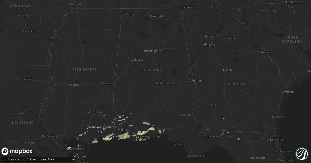
Hail Map in Alabama on March 9, 2011
Get this storm
March 9 map
$229
one time, instant access
Download today. No call, no setup
Keep the $229
Bought the map and want the full workflow? Apply the entire $229 to a subscription within 7 days. None of it is wasted.
Every map, not just this one
This buys you this map. Subscription and you get every map we run, in the markets you choose from a few cities to whole states to nationwide. Plus real-time alerts the moment a storm fires.
Contact data
Name, contact info, occupancy, even credit band for addresses in the footprint. You go from where it hit to who to call.
Become the source they trust
Unlimited branding weather history reports on demand. You already have the documented answer ready for the property owner, and you are the one who showed up with it.
Property data and RoofTrace estimates
Pull up any address you have got, its value and the exact code rules for that jurisdiction, straight from One Click Code. Then RoofTrace estimates the squares, pitch, and roof value, priced the way you price.
Storm reports in Alabama
Alabama
| Date | Description |
|---|---|
| 03/09/201111:15 AM CST | Tree down along highway 10 east near abbeville. |
| 03/09/201111:10 AM CST | Trees down along highway 46. |
| 03/09/201111:10 AM CST | Trees down along highway 115. |
| 03/09/201110:45 AM CST | *** 1 inj *** mobile home flipped over and destroyed. Occupant received minor cut to hand. Possible tornado. |
| 03/09/201110:21 AM CST | Trees and power lines reported down on the pike/dale county lines. Nws survey team has ruled the damage to be associated with straight line winds. |
| 03/09/201110:15 AM CST | Minor damage to a few homes in ariton due to falling trees. |
| 03/09/20119:59 AM CST | Trees down in northwest coffee county. |
| 03/09/20119:50 AM CST | Roof damage and trees down in community of perdue. |
| 03/09/20119:40 AM CST | Trees snapped and blown over across campus. |
| 03/09/20119:35 AM CST | Tree down on head farm road. |
| 03/09/20119:32 AM CST | Trees and power lines down near airport road and south bypass. |
| 03/09/20119:31 AM CST | Baldwin county ema reporting damage in the form of several roofs blown off houses. Streets affected include first and fourth street as well as highway 104 and fourth st |
| 03/09/20119:30 AM CST | Tree down on highway 55 south near guardian angel. |
| 03/09/20119:30 AM CST | Power line down on bay branch road. |
| 03/09/20119:30 AM CST | One tree down on power lines. |
| 03/09/20119:29 AM CST | Power line down near south bypass. |
| 03/09/20119:27 AM CST | Damage to metal awning at andalusia elementary school on highway 29 south. |
| 03/09/20119:21 AM CST | Debris spotted swirling in the air by a member of the fire department. |
| 03/09/20119:15 AM CST | *** 1 inj *** several homes experiecned severe roof damage. A utility trailer was carried 50 to 80 yards. A truck that was backing out of the post office parking lot wa |
| 03/09/20119:12 AM CST | Tree down near intersection of rosin ridge road and knowels drive. |
| 03/09/20118:48 AM CST | 13550 fred freedland rd....barn destroyed...horses with minor injuries...multiple trees/power lines down...double wide home off foundation. |
| 03/09/20118:40 AM CST | Public report of tornado near schillinger and theodore dawes rd. Clear vortex containing tree limbs and bushes. |
| 03/09/20118:39 AM CST | Near intersection of theodore dawes rd. And old pascagoula rd...canopy ripped off bp station...severe damage to hardware store...damage to popeyes restaurant...house da |
| 03/09/20118:38 AM CST | Near intersection of theodore dawes rd. And old pascagoula rd...canopy ripped off bp station...severe damage to hardware store...damage to popeyes restaurant...house da |
| 03/09/20118:38 AM CST | Confirmed tornado near tillmans corner affecting old pascagoula road and theodore dawes road. Bp station awning/roof damaged. Trees down. |
| 03/09/20118:30 AM CST | 13550 fred freedland rd....barn destroyed...horses with minor injuries...multiple trees/power lines down...double wide home off foundation. |
| 03/09/20118:02 AM CST | Numerous trees and limbs down near searcy hospital. Power outages across the area have been reported. |
| 03/09/20117:48 AM CST | A local report indicates 1.00 inch wind near CITRONELLE |
| 03/09/20116:56 AM CST | Several trees and power lines down in wiggins. A tree also down on a house on college ave. |
| 03/09/20116:05 AM CST | Tree through the roof of a home on finner drive. |
Cities Impacted by Hail Map on March 9, 2011
- Lillian, AL
- Pensacola, FL
- Ocean Springs, MS
- Gulf Breeze, FL
- Moultrie, GA
- Greenville, FL
- Summerdale, AL
- Elberta, AL
- Robertsdale, AL
- Foley, AL
- Holt, FL
- Milton, FL
- Grand Bay, AL
- Fairhope, AL
- Irvington, AL
- Coden, AL
- Bayou La Batre, AL
- Theodore, AL
- Daphne, AL
- Lucedale, MS
- Lebanon, TN
- Mount Juliet, TN
- Cantonment, FL
- Jay, FL
- Axis, AL
- Little River, AL
- Orange Beach, AL
- Beaumont, MS
- Eglin Afb, FL
- Perkinston, MS
- Braithwaite, LA
- Monticello, FL
- Defuniak Springs, FL
- Port Sulphur, LA
- Moss Point, MS
- Vancleave, MS
- Pascagoula, MS
- Chunchula, AL
- Citronelle, AL
- Gautier, MS
- Pass Christian, MS
- Bay Minette, AL
- Poplarville, MS
- Biloxi, MS
- Diberville, MS
- Niceville, FL
- Eight Mile, AL
- Saraland, AL
- Carriere, MS
- Picayune, MS
- Baker, FL
- Saint Rose, LA
- Saucier, MS
- Bagdad, FL
- Seminole, AL
- Pearl River, LA
- Lacombe, LA
- Lafitte, LA
- McIntosh, AL
- Deer Park, AL
- New Orleans, LA
- Live Oak, FL
- Kenner, LA
- Barataria, LA
- Shalimar, FL
- Mount Vernon, AL
- Silverhill, AL
- Eustis, FL
- Stockton, AL


