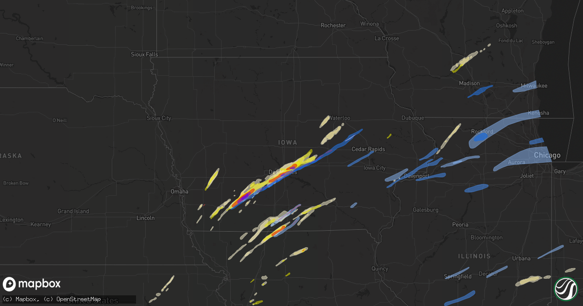
Hail Map in Iowa on March 5, 2022
Get this storm
March 5 map
$229
one time, instant access
Download today. No call, no setup
Keep the $229
Bought the map and want the full workflow? Apply the entire $229 to a subscription within 7 days. None of it is wasted.
Every map, not just this one
This buys you this map. Subscription and you get every map we run, in the markets you choose from a few cities to whole states to nationwide. Plus real-time alerts the moment a storm fires.
Contact data
Name, contact info, occupancy, even credit band for addresses in the footprint. You go from where it hit to who to call.
Become the source they trust
Unlimited branding weather history reports on demand. You already have the documented answer ready for the property owner, and you are the one who showed up with it.
Property data and RoofTrace estimates
Pull up any address you have got, its value and the exact code rules for that jurisdiction, straight from One Click Code. Then RoofTrace estimates the squares, pitch, and roof value, priced the way you price.
Storm reports in Iowa
Iowa
| Date | Description |
|---|---|
| 03/05/20225:59 PM CST | Storm chaser report of significant tornado damage with trees snapped and structural damage via twitter. |
| 03/05/20225:59 PM CST | Tornado damage via nwschat - significant home damage 2 se of chariton. Roof and walls gone. |
| 03/05/20225:55 PM CST | Sheriff relayed tornado report on the ground in corydon. |
| 03/05/20225:54 PM CST | Tornado damage report via nwschat - city of chariton is fine. 1 mile south of town has a row of 15 power poles down. |
| 03/05/20225:54 PM CST | Public report via phone call - heavy damage... Roofs ripped off... Metal building flattened/completely gone. |
| 03/05/20225:48 PM CST | Tornado reported via spotter network - family member just texted me a picture of a cone tornado in progress just sw of chariton just a couple minutes ago. They are seek |
| 03/05/20225:46 PM CST | Tornado on the ground... House reportedly flattened. |
| 03/05/20225:44 PM CST | Storm chaser report of twin tornadoes on the ground east of derby. |
| 03/05/20225:38 PM CST | Tornado report via phone call. |
| 03/05/20225:37 PM CST | Tornado on the ground reported via public. |
| 03/05/20225:36 PM CST | Storm chasers reported tornado still on the ground just east of derby. Location estimated. |
| 03/05/20225:35 PM CST | Storm chaser report of two tornadoes on the ground west of millerton. |
| 03/05/20225:34 PM CST | Public report of 2.50 inch or greater hail stones in pleasant hill via twitter. |
| 03/05/20225:33 PM CST | Tornado report via twitter. |
| 03/05/20225:25 PM CST | Emergency management relayed law enforcement report of a tornado on the ground 3 miles w and 1 mile s of humeston. At least one home damaged. |
| 03/05/20225:23 PM CST | Tornado report of a tornado on the ground west of humeston via public and storm chaser. |
| 03/05/20225:21 PM CST | Storm chaser report of tornado damage near patterson... Ia via twitter. |
| 03/05/20225:20 PM CST | Tornado damage report via spotter network - apparent damage to several houses and structures just south of hwy g24 and r57 in norwalk. Apparent tornado path |
| 03/05/20225:12 PM CST | Tornado ongoing report via spotter network - large rain wrapped multi vortex tornado on the ground 2 miles north of my location moving ne |
| 03/05/20225:12 PM CST | Tornado damage report via spotter network - there is damage to a structure here as well as extensive tree damage in this area |
| 03/05/20225:09 PM CST | Multiple reports of tornado on the ground via public and fire fighter confirmed in norwalk. |
| 03/05/20225:07 PM CST | Storm chaser report of tornado damage along i-35 and 2 miles n or rt. 92 via twitter. |
| 03/05/20225:00 PM CST | Tornado damage report via spotter network - 12 trees snapped branches snapped... Path a couple hundred yards wide on clark tower road 1/2 mile north of st charles road |
| 03/05/20224:51 PM CST | Tornado damage reported via spotter network - tree damage and minor damage to a home at this location. |
| 03/05/20224:50 PM CST | Tornado damage report via spotter network - barns destroyed and houses badly damaged in winterset |
| 03/05/20224:49 PM CST | Storm chaser report of baseball size hail accompanied with significant damage to vehicles via twitter. |
| 03/05/20224:49 PM CST | Report from mping: quarter |
| 03/05/20224:48 PM CST | Tornado damage in wintersett to shed reported via twitter. |
| 03/05/20224:47 PM CST | Tornado damage report via spotter network - homes and trees damaged and a garage was destroyed on 169 |
| 03/05/20224:35 PM CST | Tornado ongoing with debris s of winterset - multiple reports via trained spotter and emergency managers. |
| 03/05/20224:35 PM CST | Trained spotter reports large tornado on the ground southwest of winterset... Approaching time. Debris visible. Location estimated. |
| 03/05/20224:28 PM CST | Storm chaser confirmed tornado via twitter. |
| 03/05/20224:22 PM CST | Trained spotter report of 2 inch hail in orient... Ia sn#52263. |
| 03/05/20224:19 PM CST | 2+ inch hail report via storm chaser on twitter nw or orient... Ia. |
| 03/05/20224:13 PM CST | Spotter report of ongoing tennis ball hail east northeast of orient. |
| 03/05/20224:10 PM CST | Storm chaser report of tornado nw or cromwell via twitter. |
| 03/05/20224:08 PM CST | Report from mping: golf ball |
| 03/05/20224:07 PM CST | Delayed report. Golf ball to baseball hail reported. Report of numerous migratory birds killed by hail. Time estimated by radar. |
| 03/05/20224:06 PM CST | Storm chaser confirmed tornado on ground with video and damage to barn structure via twitter. |
| 03/05/20224:06 PM CST | Hail report of 1 inch via spotternetwork w of orient sn#52260. |
| 03/05/20223:55 PM CST | Hail report of 1.75 inches north of prescott... Iowa via spotternetwork sn#52258. |
| 03/05/20223:54 PM CST | Hail report of 1.5 inches west of orient... Iowa via spotternetwork sn#52257. |
| 03/05/20223:42 PM CST | Quarter to ping pong sized hail reported southeast of nodaway... Iowa. |
| 03/05/20223:40 PM CST | Multiple reports of brief tornado touchdown south of corning. |
| 03/05/20223:16 PM CST | Damage to roof and flipped trampoline. |
| 03/05/20223:15 PM CST | Report from mping: quarter |
| 03/05/20223:02 PM CST | Corrects previous tornado report from 1 ne emerson. Multiple storm chasers reporting a tornado just northeast of emerson. |
| 03/05/20223:01 PM CST | Powerlines down and outbuilding destroyed. |
| 03/05/20222:06 PM CST | Social media picture of quarter size hail. |
| 03/05/20222:30 AM CST | At 830 PM CST, a severe thunderstorm was located over Fort Madison, moving east at 55 mph. HAZARD...60 mph wind gusts. SOURCE...Radar indicated. IMPACT...Expect damage to roofs, siding, and trees. This severe thunderstorm will remain over mainly rural areas of northeastern Lee County, including the following locations... Pollmiller Park, Sawyer, Wever, Bluff Park, Fort Madison Municipal Arpt and Augusta. |
| 03/05/20222:29 AM CST | At 829 PM CST, severe thunderstorms were located along a line extending from near East Dubuque to near Canton, moving northeast at 50 mph. HAZARD...60 mph wind gusts and quarter size hail. SOURCE...Radar indicated. IMPACT...Hail damage to vehicles is expected. Expect wind damage to roofs, siding, and trees. Locations impacted include... Dubuque, Galena, Asbury, Bellevue, Cascade, Epworth, East Dubuque, Peosta, Andrew, Scales Mound, La Motte, Menominee, Onslow, Rickardsville, Sherrill, Springbrook, Council Hill, St. Donatus, Centralia and Sageville. |
| 03/05/20222:26 AM CST | At 826 PM CST, severe thunderstorms were located along a line extending from near Wilton to Illinois City to New Boston, moving northeast at 65 mph. HAZARD...60 mph wind gusts and quarter size hail. SOURCE...Radar indicated. IMPACT...Hail damage to vehicles is expected. Expect wind damage to roofs, siding, and trees. Severe thunderstorms will be near... Durant around 830 PM CST. Blue Grass, Andalusia and Montpelier around 835 PM CST. Aledo, Walcott and Buffalo around 840 PM CST. Davenport, Rock Island, Eldridge, Viola, Long Grove, Matherville, Reynolds, Donahue, Hamlet and Boden around 845 PM CST.Other locations in the path of these severe thunderstorms includeMoline, Bettendorf, East Moline, Silvis, Sherrard, Riverdale, Cable,Taylor Ridge, DeWitt, Milan, Le Claire, Hampton, Rapids City, OakGrove, McCausland, Camanche, Coal Valley, Orion, Port Byron,Princeton, Cordova, Low Moor, Warner, Lynn Center, Colona andCleveland. |
| 03/05/20222:16 AM CST | At 816 PM CST, severe thunderstorms were located along a line extending from near Mount Union to near Lowell, moving east at 40 mph. HAZARD...60 mph wind gusts. SOURCE...Radar indicated. IMPACT...Expect damage to roofs, siding, and trees. Severe thunderstorms will be near... Danville and Middletown around 825 PM CST. Mediapolis and Iowa Army Ammunition Plant around 830 PM CST. West Burlington around 835 PM CST.Other locations in the path of these severe thunderstorms includeBurlington, Carman, Gulf Port, Gladstone and Stronghurst. |
| 03/05/20222:11 AM CST | At 810 PM CST, severe thunderstorms were located along a line extending from Lancaster to near Bernard, moving northeast at 50 mph. HAZARD...60 mph wind gusts and penny size hail. SOURCE...Radar indicated. IMPACT...Expect damage to roofs, siding, and trees. Severe thunderstorms will be near... Lancaster around 815 PM CST. Dubuque around 820 PM CST. Hazel Green and Dickeyville around 840 PM CST. Cuba City around 845 PM CST.Other locations impacted by these severe thunderstorms includeKieler, Lock And Dam 11, Big H Campground, Sandy Hook, Arthur, Potosiand North Buena Vista. |
| 03/05/20222:06 AM CST | At 806 PM CST, severe thunderstorms were located along a line extending from near Toddville to near Marengo, moving east at 40 mph. HAZARD...60 mph wind gusts and penny size hail. SOURCE...Trained weather spotters. IMPACT...Expect damage to roofs, siding, and trees. Severe thunderstorms will be near... Hiawatha, Robins, Center Point, Palo and Toddville around 810 PM CST. Alburnett around 815 PM CST. Marion around 820 PM CST. Cedar Rapids, Fairfax, Central City and Whittier around 825 PM CST.Other locations in the path of these severe thunderstorms includeSpringville, Shueyville, Waubeek, Ely, Viola, Bertram, Mount Vernonand Lisbon. |
| 03/05/20221:43 AM CST | At 743 PM CST, severe thunderstorms were located along a line extending from near Tiffin to near Harper, moving east at 50 mph. HAZARD...60 mph wind gusts. SOURCE...Radar indicated. IMPACT...Expect damage to roofs, siding, and trees. Severe thunderstorms will be near... Coralville, North Liberty, Tiffin, University Heights and Oakdale around 750 PM CST. Iowa City, Solon and Lake Macbride State Park around 755 PM CST.Other locations in the path of these severe thunderstorms includeKalona, Richmond, Riverside and Lone Tree. |
| 03/05/20221:34 AM CST | At 734 PM CST, severe thunderstorms were located along a line extending from near Center Point to near Shellsburg to near Ladora, moving east at 50 mph. HAZARD...60 mph wind gusts and quarter size hail. SOURCE...Trained weather spotters. IMPACT...Hail damage to vehicles is expected. Expect wind damage to roofs, siding, and trees. Severe thunderstorms will be near... Center Point, Atkins, Palo and Shellsburg around 740 PM CST. Hiawatha, Blairstown and Toddville around 745 PM CST. Robins, Central City, Alburnett, Paris and Conroy around 750 PM CST.Other locations in the path of these severe thunderstorms includeMarion, Coggon, Norway, Cedar Rapids, Fairfax, Walford, Prairieburg,Waubeek, Whittier and Amana. |
| 03/05/20221:30 AM CST | At 730 PM CST, severe thunderstorms were located along a line extending from near Downing to 7 miles north of Brashear, moving east at 50 mph. HAZARD...60 mph wind gusts. SOURCE...Radar indicated. IMPACT...Expect damage to roofs, siding, and trees. Severe thunderstorms will be near... Memphis around 740 PM CST. Greensburg around 745 PM CST. Rutledge around 750 PM CST.Other locations in the path of these severe thunderstorms includeSouth Gorin. |
| 03/05/20221:26 AM CST | At 726 PM CST, a severe thunderstorm was located over Springville, or 10 miles west of Anamosa, moving northeast at 60 mph. HAZARD...60 mph wind gusts and penny size hail. SOURCE...Trained weather spotters. IMPACT...Expect damage to roofs, siding, and trees. Locations impacted include... Cedar Rapids, Anamosa, Marion, Monticello, Robins, Ely, Springville, Hopkinton, Bertram, Martelle, Prairieburg, Waubeek, Stone City, Viola, Whittier, Langworthy, Squaw Creek Park, Marion Airport, Monticello Municipal Airport and Matsell Bridge Natural Area. |
| 03/05/202212:55 AM CST | At 655 PM CST, a severe thunderstorm was located over Milan, moving east at 35 mph. HAZARD...Golf ball size hail and 60 mph wind gusts. SOURCE...Emergency management. IMPACT...People and animals outdoors will be injured. Expect hail damage to roofs, siding, windows, and vehicles. Expect wind damage to roofs, siding, and trees. Locations impacted include... Milan, Green City, Novinger, Greencastle, Browning, Pollock, Worthington, Livonia, Lemons, Reger, Green Castle and Winigan. |
| 03/05/202212:55 AM CST | At 655 PM CST, a severe thunderstorm was located near Conroy, or near Marengo, moving northeast at 60 mph. HAZARD...60 mph wind gusts and penny size hail. SOURCE...Radar indicated. IMPACT...Expect damage to roofs, siding, and trees. Locations impacted include... Cedar Rapids, Marengo, Marion, Hiawatha, Mount Vernon, Robins, Williamsburg, Fairfax, Ely, Walford, Swisher, Shueyville, Norway, Bertram, Amana, Conroy, Middle Amana, Upper South Amana, Squaw Creek Park and East Amana. |
| 03/05/202212:17 AM CST | At 617 PM CST, a severe thunderstorm was located 8 miles northwest of Milan, moving northeast at 40 mph. HAZARD...60 mph wind gusts and quarter size hail. SOURCE...Radar indicated. IMPACT...Hail damage to vehicles is expected. Expect wind damage to roofs, siding, and trees. Locations impacted include... Milan, Unionville, Green City, Humphreys, Pollock, Harris, Osgood, Lemons and Reger. |
| 03/04/202211:53 PM CST | At 552 PM CST, a severe thunderstorm was located over Adventureland Amusement Park, or over Altoona, moving northeast at 45 mph. HAZARD...Ping pong ball size hail and 60 mph wind gusts. SOURCE...Radar indicated. IMPACT...People and animals outdoors will be injured. Expect hail damage to roofs, siding, windows, and vehicles. Expect wind damage to roofs, siding, and trees. This severe thunderstorm will be near... Mitchellville around 605 PM CST.Other locations in the path of this severe thunderstorm includeColfax, Newton and Baxter.This includes the following highways... Interstate 35 between mile markers 87 and 93. Interstate 80 between mile markers 131 and 166. Interstate 235 between mile markers 4 and 14. |
| 03/04/202211:19 PM CST | At 518 PM CST, a severe thunderstorm was located near Roland, or near Nevada, moving northeast at 55 mph. HAZARD...60 mph wind gusts and quarter size hail. SOURCE...Radar indicated. IMPACT...Hail damage to vehicles is expected. Expect wind damage to roofs, siding, and trees. Locations impacted include... Eldora.This includes Interstate 35 between mile markers 115 and 122. |
| 03/04/202210:56 PM CST | At 455 PM CST, a severe thunderstorm was located near Leon, moving northeast at 45 mph. HAZARD...Ping pong ball size hail and 60 mph wind gusts. SOURCE...Radar indicated. IMPACT...People and animals outdoors will be injured. Expect hail damage to roofs, siding, windows, and vehicles. Expect wind damage to roofs, siding, and trees. This severe thunderstorm will be near... Leon around 500 PM CST.This includes Interstate 35 between mile markers 5 and 24. |
| 03/04/202210:56 PM CST | At 455 PM CST, a severe thunderstorm was located over Eagleville, or 14 miles north of Bethany, moving northeast at 55 mph. HAZARD...60 mph wind gusts and quarter size hail. SOURCE...Radar indicated. IMPACT...Hail damage to vehicles is expected. Expect wind damage to roofs, siding, and trees. Locations impacted include... Ridgeway, Eagleville, Cainsville, Blythedale and Pleasanton. This includes Interstate 35 in Missouri between mile markers 102 and114. |
| 03/04/202210:53 PM CST | At 453 PM CST, a severe thunderstorm was located over Earlham, or 11 miles northwest of Winterset, moving northeast at 40 mph. HAZARD...60 mph wind gusts and quarter size hail. SOURCE...Radar indicated. IMPACT...Hail damage to vehicles is expected. Expect wind damage to roofs, siding, and trees. This severe thunderstorm will be near... De Soto around 505 PM CST. Van Meter around 510 PM CST.Other locations in the path of this severe thunderstorm include Adel,Dallas Center, Waukee, Urbandale and Grimes.This includes the following highways... Interstate 35 between mile markers 71 and 72. Interstate 80 between mile markers 97 and 127. Interstate 235 between mile markers 1 and 2. |
| 03/04/20229:48 PM CST | At 348 PM CST, a severe thunderstorm was located near Lake Icaria, or 8 miles northwest of Corning, moving northeast at 55 mph. HAZARD...60 mph wind gusts and quarter size hail. SOURCE...Radar indicated. IMPACT...Hail damage to vehicles is expected. Expect wind damage to roofs, siding, and trees. Locations impacted include... Greenfield. |
| 03/04/20229:33 PM CST | At 333 PM CST, a severe thunderstorm was located 10 miles northeast of Walnut, or 12 miles southwest of Audubon, moving northeast at 55 mph. HAZARD...Ping pong ball size hail and 60 mph wind gusts. SOURCE...Radar indicated. IMPACT...People and animals outdoors will be injured. Expect hail damage to roofs, siding, windows, and vehicles. Expect wind damage to roofs, siding, and trees. This severe thunderstorm will be near... Audubon around 350 PM CST. |
| 03/04/20229:28 PM CST | At 327 PM CST, a severe thunderstorm was located near Maryville, moving northeast at 50 mph. HAZARD...60 mph wind gusts and quarter size hail. SOURCE...Radar indicated. IMPACT...Hail damage to vehicles is expected. Expect wind damage to roofs, siding, and trees. Locations impacted include... Maryville, Grant City, Ravenwood, Irena, Sheridan and Parnell. |
| 03/04/20229:21 PM CST | At 320 PM CST, a severe thunderstorm was located near Walnut, or 11 miles west of Atlantic, moving north at 50 mph. HAZARD...Golf ball size hail and 70 mph wind gusts. SOURCE...Radar indicated. IMPACT...People and animals outdoors will be injured. Expect hail damage to roofs, siding, windows, and vehicles. Expect considerable tree damage. Wind damage is also likely to mobile homes, roofs, and outbuildings. This severe thunderstorm will remain over mainly rural areas of northeastern Pottawattamie and eastern Shelby Counties, including the following locations... Elk Horn Creek Recreation Area and Prairie Rose State Park.This includes Interstate 80 in Iowa between mile markers 46 and 48. |
| 03/04/20229:17 PM CST | At 317 PM CST, a severe thunderstorm was located near Clarinda, or 15 miles northwest of Bedford, moving northeast at 45 mph. HAZARD...60 mph wind gusts and quarter size hail. SOURCE...Radar indicated. IMPACT...Hail damage to vehicles is expected. Expect wind damage to roofs, siding, and trees. Locations impacted include... Corning and Lake Icaria. |
| 03/04/20229:02 PM CST | Awos. |
| 03/04/20228:57 PM CST | At 257 PM CST, a severe thunderstorm was located over Emerson, or 34 miles southwest of Atlantic, moving northeast at 40 mph. HAZARD...Golf ball size hail and 70 mph wind gusts. SOURCE...Radar indicated. IMPACT...People and animals outdoors will be injured. Expect hail damage to roofs, siding, windows, and vehicles. Expect considerable tree damage. Wind damage is also likely to mobile homes, roofs, and outbuildings. Locations impacted include... Elliott. |
| 03/04/20228:46 PM CST | Reported on rsois at nws office. |
| 03/04/20228:46 PM CST | Corrects previous tstm wnd gst report from davenport municipality. Reported on rsois at nws office. |
| 03/04/20228:45 PM CST | Delayed report. Housing for traffic lights at the intersection of division and 76th streets were physically turned by thunderstorm winds. |
| 03/04/20228:33 PM CST | At 233 PM CST, a severe thunderstorm was located over Farragut, or 21 miles northwest of Tarkio, moving northeast at 50 mph. HAZARD...60 mph wind gusts and quarter size hail. SOURCE...Radar indicated. IMPACT...Hail damage to vehicles is expected. Expect wind damage to roofs, siding, and trees. This severe thunderstorm will be near... Shenandoah around 240 PM CST. Essex around 250 PM CST.Other locations in the path of this severe thunderstorm includeEmerson, Red Oak, Stanton and Elliott. |
| 03/04/20228:22 PM CST | A local report indicates 65 MPH wind near 4 SSE MOSCOW |
| 03/04/20228:22 PM CST | A local report indicates 1.00 inch wind near 4 SSE MOSCOW |
| 03/04/20228:12 PM CST | A local report indicates 65 MPH wind near NEW VIENNA |
| 03/04/20228:00 PM CST | At 159 PM CST, a severe thunderstorm was located over Baxter, or 12 miles north of Newton, moving northeast at 60 mph. HAZARD...60 mph wind gusts and quarter size hail. SOURCE...Radar indicated. IMPACT...Hail damage to vehicles is expected. Expect wind damage to roofs, siding, and trees. Locations impacted include... Marshalltown. |
| 03/04/20227:58 PM CST | Spotter reports large tree uprooted. Time estimated from radar. |
| 03/04/20227:53 PM CST | A local report indicates 1.00 inch wind near MONTICELLO |
| 03/04/20227:35 PM CST | Iadot awos. |
| 03/04/20227:23 PM CST | Measured. |
| 03/04/20227:19 PM CST | Damage to structures and gas leaks reported by emergency management in the northwest side of vinton. Possible tornado. Time estimated from radar. |
| 03/04/20227:18 PM CST | Estimated 60-70 mph winds. |
| 03/04/20227:15 PM CST | A tornado developed about 2.5 miles southwest of vinton saturday evening... And tracked northeast through the northwest portion of vinton... Before lifting northeast of |
| 03/04/20226:41 PM CST | Tornado report via spotter network - cone tornado with power flashes 4 nne near tama. |
| 03/04/20226:24 PM CST | Tornado damage report via spotter network - - significant structure damage from earlier tornado. Lots of buildings and some homes damage. Gas leaking. Major tree damage |
| 03/04/20226:23 PM CST | Tornado report via twitter. |
| 03/04/20226:21 PM CST | Emergency manager report of multiple houses in area leveled via nwschat. |
| 03/04/20226:17 PM CST | Destroyed trailer home... Heavily damaged residency on the south side of town. Trees down. Spotter id: wn400. |
| 03/04/20226:17 PM CST | Tornado damage via spotter network - 18 wheeler overturned |
| 03/04/20226:15 PM CST | A local report indicates a tornado near 5 NE KELLOGG |
| 03/04/20226:12 PM CST | Tornado reported on the ground northeast of kellogg via nwschat. |
| 03/04/20226:12 PM CST | Tornado image from public via facebook. |
| 03/04/20226:07 PM CST | Report from mping: quarter |
Cities Impacted by Hail Map on March 5, 2022
- Bondurant, IA
- Prole, IA
- Baxter, IA
- Mitchellville, IA
- Ira, IA
- Van Meter, IA
- Fontanelle, IA
- Norwalk, IA
- Winterset, IA
- Newton, IA
- Berwick, IA
- Carlisle, IA
- Windsor Heights, IA
- Waukee, IA
- Runnells, IA
- Cumming, IA
- Maxwell, IA
- Earlham, IA
- Prescott, IA
- Orient, IA
- Dexter, IA
- Creston, IA
- Altoona, IA
- Des Moines, IA
- Ankeny, IA
- Corning, IA
- Colfax, IA
- Pleasant Hill, IA
- Mingo, IA
- West Des Moines, IA
- Greenfield, IA
- Garwin, IA
- Gladbrook, IA
- Traer, IA
- Toledo, IA
- Seneca, KS
- Centralia, KS
- Villisca, IA
- Stanton, IA
- Clarinda, IA
- Essex, IA
- Red Oak, IA
- Nodaway, IA
- Laurel, IA
- Gilman, IA
- Kellogg, IA
- Butler, MO
- Bridgewater, IA
- Onaga, KS
- Vermillion, KS
- Frankfort, KS
- Bolckow, MO
- Gentry, MO
- Guilford, MO
- Stanberry, MO
- Conception, MO
- Appleton City, MO
- Promise City, IA
- Plano, IA
- Lenox, IA
- Eagleville, MO
- Ridgeway, MO
- Blythedale, MO
- Leon, IA
- Merrimac, WI
- Lodi, WI
- Decatur, IA
- Amsterdam, MO
- Amoret, MO
- Adrian, MO
- Rich Hill, MO
- Greenwood, MO
- Lees Summit, MO
- Shannon, IL
- Freeport, IL
- Lanark, IL
- Pearl City, IL
- Malvern, IA
- Emerson, IA
- Hastings, IA
- Montrose, MO
- Clinton, MO
- Corydon, IA
- Riverton, IA
- Imogene, IA
- Sidney, IA
- Farragut, IA
- Muscatine, IA
- King City, MO
- Cainsville, MO
- Davis City, IA
- Lineville, IA
- Fulton, IL
- Thomson, IL
- Excelsior Springs, MO
- Urich, MO
- Creighton, MO
- Ottumwa, IA
- Waterloo, IA
- La Porte City, IA
- Allerton, IA
- Bethany, MO
- Mount Ayr, IA
- Hatfield, MO
- Lamoni, IA
- Grand River, IA
- Grant City, MO
- Kellerton, IA
- Denver, MO
- Colo, IA
- Oakland, IL
- Newman, IL
- Camargo, IL
- Arcola, IL
- Tuscola, IL
- Hindsboro, IL
- Trenton, MO
- Melrose, IA
- Marshall, IN
- Marne, IA
- Walnut, IA
- Hancock, IA
- Pardeeville, WI
- Reinbeck, IA
- Buckingham, IA
- Hudson, IA
- Cambria, WI
- Portage, WI
- Poynette, WI
- Baraboo, WI
- Prairie Du Sac, WI
- Wyocena, WI
- Savanna, IL
- Dakota, IL
- Cedarville, IL
- Chadwick, IL
- Mount Carroll, IL
- Patterson, IA
- Melbourne, IA
- Rhodes, IA
- Clive, IA
- Macksburg, IA
- Urbandale, IA
- Prairie City, IA
- Stuart, IA
- Bonnots Mill, MO
- Chamois, MO
- Darlington, MO
- Albany, MO
- Franklin, MO
- Jamesport, MO
- Raymore, MO
- Weldon, IA
- Garden Grove, IA
- Humeston, IA
- Markesan, WI
- Van Wert, IA
- Worth, MO
- Kearney, MO
- Elk Horn, IA
- Humboldt, IL
- Chrisman, IL
- Hume, IL
- Metcalf, IL
- Brocton, IL
- Albia, IA
- Moravia, IA
- Galt, MO
- Humphreys, MO
- Milan, MO
- Dike, IA
- Cedar Falls, IA
- Grundy Center, IA
- Haverhill, IA
- Booneville, IA
- Pollock, MO
- Audubon, IA
- Kimballton, IA
- Russell, IA
- Randolph, WI
- Archie, MO
- Dysart, IA
- Sheridan, MO
- Chillicothe, IA
- Eddyville, IA
- Dana, IN
- Westmoreland, KS
- Massena, IA
- Blakesburg, IA
- Seymour, IA
- Mystic, IA
- Olsburg, KS
- Chariton, IA
- Blairstown, MO
- Richards, MO
- Chilhowee, MO
- Coin, IA
- Blanchard, IA
- Waveland, IN
- Hamilton, MO
- Kidder, MO
- Kingston, MO
- Oakland, IA
- Exira, IA
- Redding, IA
- Derby, IA
- Woodburn, IA
- Avoca, IA
- Lawson, MO
- Afton, IA
- New Hampton, MO
- Martinsville, MO
- Bloomingdale, IN
- Crawfordsville, IN
- Grinnell, IA
- Garrison, IA
- Mount Auburn, IA
- Clutier, IA
- Tama, IA
- Vining, IA
- Center Point, IA
- Elberon, IA
- Keystone, IA
- Chelsea, IA
- Walker, IA
- Vinton, IA
- Urbana, IA
- Van Horne, IA
- Indianola, IA
- Clio, IA
- Mercer, MO
- Cedar Rapids, IA
- Williamsburg, IA
- Amana, IA
- Marengo, IA
- Middle Amana, IA
- Fairfax, IA
- South Amana, IA
- Homestead, IA
- Ely, IA
- Conroy, IA
- Swisher, IA
- Fairfield, IA
- Libertyville, IA
- Batavia, IA
- Walcott, IA
- Davenport, IA
- Blue Grass, IA
- Camanche, IA
- Stockton, IA
- Princeton, IA
- Morrison, IL
- Albany, IL
- Letts, IA
- Erie, IL
- Long Grove, IA
- Le Claire, IA
- Fenton, IL
- Fruitland, IA
- Cordova, IL
- Eldridge, IA
- Wilton, IA
- Atalissa, IA
- Nichols, IA
- Moscow, IA
- West Liberty, IA
- Durant, IA
- De Witt, IA
- Clinton, IA
- Lincoln, MO
- Warsaw, MO
- Cole Camp, MO
- Versailles, MO
- Stover, MO
- Antwerp, OH
- Monroeville, IN
- Paulding, OH
- Hoagland, IN
- Fort Wayne, IN
- Lagro, IN
- Woodburn, IN
- New Haven, IN
- Ossian, IN
- Yoder, IN
- Markle, IN
- Payne, OH
- Huntington, IN
- Roanoke, IN
- Wabash, IN
- Zanesville, IN
- Andrews, IN
- Ingalls, IN
- Indianapolis, IN
- Fishers, IN
- Mccordsville, IN
- Fortville, IN
- Frankfort, IN
- Michigantown, IN
- Versailles, OH
- Marshalltown, IA
- Monticello, IA
- Sauk City, WI
- Cameron, MO
- Rayville, MO
- Chillicothe, MO
- Grain Valley, MO
- Moundville, MO
- Nevada, MO
- Deerfield, MO
- Blue Springs, MO
- Prophetstown, IL
- Rock Island, IL
- Silvis, IL
- Coal Valley, IL
- Moline, IL
- Milan, IL
- Geneseo, IL
- Carbon Cliff, IL
- East Moline, IL
- Colona, IL
- Rock Falls, IL
- Lyndon, IL
- Dixon, IL
- Franklin Grove, IL
- Ashton, IL
- Tampico, IL
- Harmon, IL
- Sterling, IL
- Genoa City, WI
- Loves Park, IL
- Mount Morris, IL
- Byron, IL
- Capron, IL
- Zion, IL
- Twin Lakes, WI
- Kenosha, WI
- Belvidere, IL
- Poplar Grove, IL
- Monroe Center, IL
- Hebron, IL
- Wilmot, WI
- Ringwood, IL
- Rockford, IL
- Stillman Valley, IL
- Spring Grove, IL
- Burlington, WI
- Caledonia, IL
- Silver Lake, WI
- Salem, WI
- Pleasant Prairie, WI
- Leaf River, IL
- Oregon, IL
- Wonder Lake, IL
- Cherry Valley, IL
- Marengo, IL
- Chana, IL
- Garden Prairie, IL
- Woodstock, IL
- Lake Geneva, WI
- Bristol, WI
- Richmond, IL
- Antioch, IL
- Harvard, IL
- Walworth, WI
- Trevor, WI
- Winnebago, IL
- Davis Junction, IL
- Lake Mills, WI
- Edgerton, WI
- Oregon, WI
- Brooklyn, WI
- Cambridge, WI
- Fort Atkinson, WI
- Stoughton, WI
- Jefferson, WI
- Milwaukee, WI
- Brookfield, WI
- Mukwonago, WI
- North Prairie, WI
- New Berlin, WI
- Waukesha, WI
- Elm Grove, WI
- Dalzell, IL
- Granville, IL
- Oglesby, IL
- Princeton, IL
- Peru, IL
- Hennepin, IL
- Depue, IL
- Spring Valley, IL
- Utica, IL
- Bureau, IL
- La Salle, IL
- Tiskilwa, IL
- Mark, IL
- Sherman, IL
- Buffalo, IL
- Springfield, IL
- Pleasant Plains, IL
- Riverton, IL
- Elkhart, IL
- Williamsville, IL
- New Berlin, IL
- Sugar Grove, IL
- Berkeley, IL
- Melrose Park, IL
- Woodridge, IL
- Lombard, IL
- Cicero, IL
- Itasca, IL
- Glen Ellyn, IL
- Hines, IL
- Montgomery, IL
- Hinckley, IL
- Saint Charles, IL
- Maywood, IL
- Berwyn, IL
- Willowbrook, IL
- Warrenville, IL
- Roselle, IL
- Westchester, IL
- Hanover Park, IL
- Brookfield, IL
- Winfield, IL
- Summit Argo, IL
- Bensenville, IL
- Sandwich, IL
- Big Rock, IL
- Chicago, IL
- Yorkville, IL
- Medinah, IL
- Waterman, IL
- Downers Grove, IL
- Clarendon Hills, IL
- Darien, IL
- Naperville, IL
- Lyons, IL
- Wood Dale, IL
- Bloomingdale, IL
- Mooseheart, IL
- Park Ridge, IL
- Batavia, IL
- Lisle, IL
- Geneva, IL
- Bellwood, IL
- Elmwood Park, IL
- Elmhurst, IL
- Aurora, IL
- North Aurora, IL
- Stone Park, IL
- Oak Brook, IL
- Glendale Heights, IL
- Lincolnwood, IL
- Leland, IL
- Addison, IL
- Skokie, IL
- Hinsdale, IL
- Schiller Park, IL
- River Forest, IL
- Wayne, IL
- Carol Stream, IL
- Elk Grove Village, IL
- Burbank, IL
- Des Plaines, IL
- Riverside, IL
- Wheaton, IL
- Oswego, IL
- Western Springs, IL
- Willow Springs, IL
- Bristol, IL
- Forest Park, IL
- Plano, IL
- Westmont, IL
- La Grange Park, IL
- River Grove, IL
- Oak Park, IL
- Broadview, IL
- Somonauk, IL
- La Grange, IL
- Bartlett, IL
- Bolingbrook, IL
- Franklin Park, IL
- West Chicago, IL
- Villa Park, IL
- Justice, IL
- Bridgeview, IL
- Niles, IL
- Harwood Heights, IL
- Elburn, IL
- Hillside, IL
- Kenilworth, IL
- Palatine, IL
- Rolling Meadows, IL
- Glenview, IL
- Wilmette, IL
- Glencoe, IL
- Mount Prospect, IL
- Arlington Heights, IL
- Northbrook, IL
- Prospect Heights, IL
- Winnetka, IL
- Wheeling, IL
- Highland Park, IL
- Morrisonville, IL
- Carlinville, IL
- Farmersville, IL
- Waggoner, IL
- Palmer, IL
- Girard, IL
- Taylorville, IL
- Harvel, IL
- Decatur, IL
- Bement, IL
- Cerro Gordo, IL
- Argenta, IL
- Milmine, IL
- Fithian, IL
- Oakwood, IL
- Attica, IN
- West Lebanon, IN
- Danville, IL
- Williamsport, IN
- Bismarck, IL


