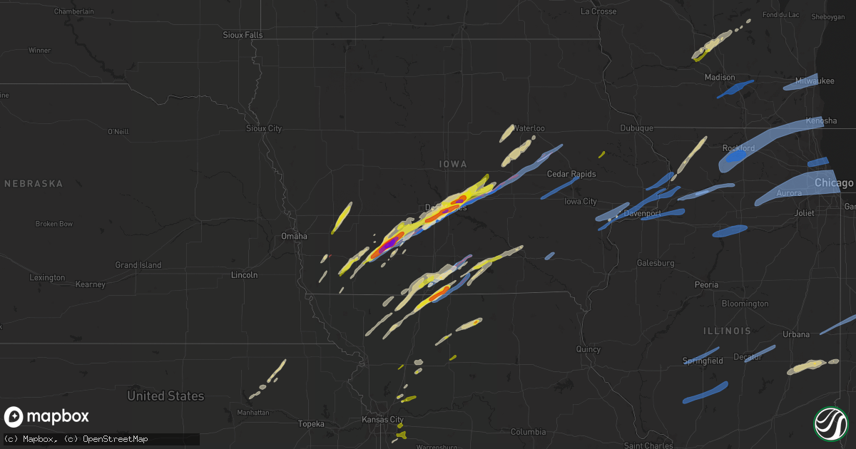
Hail Map on March 5, 2022
Get this storm
March 5 map
$229
one time, instant access
Download today. No call, no setup
Keep the $229
Bought the map and want the full workflow? Apply the entire $229 to a subscription within 7 days. None of it is wasted.
Every map, not just this one
This buys you this map. Subscription and you get every map we run, in the markets you choose from a few cities to whole states to nationwide. Plus real-time alerts the moment a storm fires.
Contact data
Name, contact info, occupancy, even credit band for addresses in the footprint. You go from where it hit to who to call.
Become the source they trust
Unlimited branding weather history reports on demand. You already have the documented answer ready for the property owner, and you are the one who showed up with it.
Property data and RoofTrace estimates
Pull up any address you have got, its value and the exact code rules for that jurisdiction, straight from One Click Code. Then RoofTrace estimates the squares, pitch, and roof value, priced the way you price.
Storm reports
Michigan
| Date | Description |
|---|---|
| 03/05/20224:00 AM CST | Siding ripped off house. Anemometer also measured 61 mph gust. |
Ohio
| Date | Description |
|---|---|
| 03/05/20224:48 AM CST | Tree downed onto a house in the 5700 block of south canterbury road in north olmsted. Time estimated from radar. |
| 03/05/20223:28 AM CST | Asos station kaoh lima. |
| 03/05/20223:25 AM CST | Picture of roof damage to a house in cygnet. Time estimated from radar. |
| 03/05/20223:23 AM CST | Barns... Trees and power poles damaged. Time estimated from radar. |
| 03/05/20223:22 AM CST | Several trees downed along reed road north of versailles. Time estimated by radar. |
| 03/05/20223:21 AM CST | Several trees downed along burns road. Time estimated by radar. |
| 03/05/20223:21 AM CST | Several trees downed along burns road. Time estimated by radar. |
| 03/05/20223:15 AM CST | Large branches downed on road z... North of road 8s. |
| 03/05/20223:05 AM CST | Numerous 3+ inch diameter tree limbs broken. Time estimated from radar. |
| 03/05/20222:50 AM CST | Power pole snapped near sr 118 and van wert decatur rd. |
Missouri
| Date | Description |
|---|---|
| 03/05/20225:56 PM CST | A local report indicates 1.00 inch wind near 1 N EXCELSIOR SPRINGS |
| 03/05/20225:55 PM CST | Via social media. |
| 03/05/20225:29 PM CST | A local report indicates 1.00 inch wind near HAMILTON |
| 03/05/20225:26 PM CST | A local report indicates 1.00 inch wind near CAMERON |
| 03/05/20225:14 PM CST | A local report indicates 1.00 inch wind near GALLATIN |
| 03/05/20224:57 PM CST | Via social media. |
| 03/05/20223:30 PM CST | A local report indicates 1.00 inch wind near 3 ENE MARYVILLE |
| 03/05/20225:02 AM CST | At 1102 PM CST, a severe thunderstorm was located over Washington, moving east at 60 mph. HAZARD...60 mph wind gusts and quarter size hail. SOURCE...Radar indicated. IMPACT...Hail damage to vehicles is expected. Expect wind damage to roofs, siding, and trees. This severe thunderstorm will be near... Augusta around 1110 PM CST. Pacific, Gray Summit and Defiance around 1115 PM CST.Other locations in the path of this severe thunderstorm includeWildwood, Ballwin, Ellisville, Clarkson Valley, Spirit of St. LouisAirport, Weldon Spring Heights, St. Peters, Manchester, Valley Park,Weldon Spring, Winchester, Twin Oaks, Harvester, Chesterfield,Kirkwood, Maryland Heights, Town and Country, Ladue, Des Peres,Glendale, Frontenac, Warson Woods, Crystal Lake Park, Creve Coeur andBridgeton.This includes the following highways... Interstate 44 in Missouri near exit 261, and between exits 272 and277. Interstate 70 in Missouri between exits 227 and 231.This also includes Babler Memorial State Park, Castlewood State Park,and First Missouri State Capitol Historic Site. |
| 03/05/20223:37 AM CST | At 936 PM CST, severe thunderstorms were located along a line extending from 11 miles south of Williamsburg to near Chamois to 7 miles north of Linn, moving east at 55 mph. HAZARD...60 mph wind gusts and penny size hail. SOURCE...Radar indicated. IMPACT...Expect damage to roofs, siding, and trees. Severe thunderstorms will be near... Hermann and Big Spring around 950 PM CST.Other locations in the path of these severe thunderstorms includeJonesburg, Warrenton, Truesdale, Wright City, Innsbrook and Treloar.This includes Interstate 70 in Missouri between exits 179 and 200. This also includes Deutschheim Historic Site. |
| 03/05/20222:35 AM CST | At 835 PM CST, a severe thunderstorm was located 7 miles northeast of Hermitage, moving east at 35 mph. HAZARD...60 mph wind gusts and quarter size hail. SOURCE...Radar indicated. IMPACT...Hail damage to vehicles is expected. Expect wind damage to roofs, siding, and trees. Locations impacted include... Lake of The Ozarks... Macks Creek... Cross Timbers... Climax Springs... Roach... Barnumton... |
| 03/05/20222:06 AM CST | At 806 PM CST, severe thunderstorms were located along a line extending from near Otterville to near Stover, moving east at 25 mph. HAZARD...60 mph wind gusts and quarter size hail. SOURCE...Radar indicated. IMPACT...Hail damage to vehicles is expected. Expect wind damage to roofs, siding, and trees. Locations impacted include... Versailles... Stover... Syracuse... Florence... |
| 03/05/20222:05 AM CST | At 804 PM CST, a severe thunderstorm was located 7 miles north of Luray, or 11 miles northwest of Kahoka, moving east at 55 mph. HAZARD...60 mph wind gusts. SOURCE...Radar indicated. IMPACT...Expect damage to roofs, siding, and trees. This severe thunderstorm will be near... Croton around 815 PM CST.Other locations in the path of this severe thunderstorm includeDonnellson, Franklin, New Boston, Nauvoo, West Point, Montrose, FortMadison and Denmark. |
| 03/05/20221:53 AM CST | At 752 PM CST, a severe thunderstorm was located over Callao, or near Macon, moving east at 55 mph. HAZARD...60 mph wind gusts and quarter size hail. SOURCE...Radar indicated. IMPACT...Hail damage to vehicles is expected. Expect wind damage to roofs, siding, and trees. Locations impacted include... Macon, Bevier, Atlanta, Callao and New Cambria. |
| 03/05/20221:40 AM CST | At 740 PM CST, severe thunderstorms were located along a line extending from Coppock to Cantril, moving east at 45 mph. HAZARD...60 mph wind gusts. SOURCE...Trained weather spotters. IMPACT...Expect damage to roofs, siding, and trees. Severe thunderstorms will be near... Wayland and Coppock around 745 PM CST. Olds around 750 PM CST. Bentonsport/Vernon around 755 PM CST. Winfield and Bonaparte around 800 PM CST.Other locations in the path of these severe thunderstorms includeDonnellson, Franklin, St. Paul, Pilot Grove and Lowell. |
| 03/05/20221:34 AM CST | At 734 PM CST, severe thunderstorms were located along a line extending from near Windsor to near Deepwater, moving southeast at 30 mph. HAZARD...60 mph wind gusts and quarter size hail. SOURCE...Radar indicated. IMPACT...Hail damage to vehicles is expected. Expect wind damage to roofs, siding, and trees. Locations impacted include... Truman Lake... Truman State Park... Warsaw... Lincoln... Cole Camp... Ionia... Palo Pinto... Lakeview Heights... Brandon... Crockerville... Zora... Racket... Edmonson... Mora... Whitakerville... |
| 03/05/20221:31 AM CST | At 731 PM CST, a severe thunderstorm was located near Marshall, moving east at 45 mph. HAZARD...60 mph wind gusts and quarter size hail. SOURCE...Radar indicated. IMPACT...Hail damage to vehicles is expected. Expect wind damage to roofs, siding, and trees. Locations impacted include... Marshall, Boonville, Fayette, Glasgow, New Franklin, Nelson, Blackwater, Franklin, Arrow Rock and Lamine.This includes Interstate 70 in Missouri between mile markers 69 and106. |
| 03/05/20221:20 AM CST | At 720 PM CST, severe thunderstorms were located along a line extending from near Clinton to near Schell City, moving southeast at 30 mph. HAZARD...60 mph wind gusts and quarter size hail. SOURCE...Radar indicated. IMPACT...Hail damage to vehicles is expected. Expect wind damage to roofs, siding, and trees. Locations impacted include... Truman Lake... Appleton City... Osceola... Lowry City... Roscoe... Tiffin... Johnson City... Taberville... Harper... Iconium... Monegaw Springs... |
| 03/05/20221:15 AM CST | At 715 PM CST, severe thunderstorms were located along a line extending from 7 miles northeast of Knob Noster to 7 miles north of Clinton to 6 miles north of Schell City, moving east at 40 mph. HAZARD...60 mph wind gusts and quarter size hail. SOURCE...Radar indicated. IMPACT...Hail damage to vehicles is expected. Expect wind damage to roofs, siding, and trees. Locations impacted include... Sedalia, Warrensburg, Clinton, Windsor, Knob Noster, Whiteman Air Force Base, La Monte, Leeton, Green Ridge, Calhoun, Deepwater, Montrose, Houstonia, Whiteman Afb, Coal, Hughesville, Rockville, Brownington, Tightwad and Sedalia Memorial Arpt. |
| 03/05/202212:52 AM CST | At 652 PM CST, severe thunderstorms were located along a line extending from 7 miles southeast of Galt to near Hale to near Higginsville, moving east at 50 mph. HAZARD...60 mph wind gusts and quarter size hail. SOURCE...Radar indicated. IMPACT...Hail damage to vehicles is expected. Expect wind damage to roofs, siding, and trees. Locations impacted include... Marshall, Brookfield, Carrollton, Marceline, Slater, Sweet Springs, Brunswick, Keytesville, Bucklin, Meadville, Hale, Laclede, Bosworth, Linneus, Wheeling, Browning, Malta Bend, Blackburn, Wakenda and Gilliam.This includes Interstate 70 in Missouri between mile markers 63 and80. |
| 03/05/202212:36 AM CST | At 635 PM CST, severe thunderstorms were located along a line extending from near Lexington to near Garden City to near Hume, moving east at 40 mph. HAZARD...60 mph wind gusts and quarter size hail. SOURCE...Radar indicated. IMPACT...Hail damage to vehicles is expected. Expect wind damage to roofs, siding, and trees. Locations impacted include... Warrensburg, Odessa, Higginsville, Lexington, Butler, Knob Noster, Concordia, Holden, Adrian, Garden City, Whiteman Air Force Base, Archie, Waverly, Leeton, Urich, Corder, Alma, Montrose, Creighton and Chilhowee.This includes Interstate 70 in Missouri between mile markers 39 and62. |
| 03/05/202212:26 AM CST | At 626 PM CST, severe thunderstorms were located along a line extending from Trenton to near Utica to near Braymer to 6 miles north of Hardin, moving east at 40 mph. HAZARD...60 mph wind gusts and quarter size hail. SOURCE...Radar indicated. IMPACT...Hail damage to vehicles is expected. Expect wind damage to roofs, siding, and trees. Locations impacted include... Chillicothe, Trenton, Lexington, Carrollton, Waverly, Norborne, Hardin, Henrietta, Wheeling, Utica, Galt, Chula, Laredo, Bogard, Tina, Ludlow, Mooresville, Tindall, Spring Hill and Avalon. |
| 03/05/202212:08 AM CST | At 608 PM CST, a severe thunderstorm was located over Lake Lotawana, moving east at 50 mph. HAZARD...60 mph wind gusts and quarter size hail. SOURCE...Radar indicated. IMPACT...Hail damage to vehicles is expected. Expect wind damage to roofs, siding, and trees. Locations impacted include... Independence, Lee's Summit, Blue Springs, Raymore, Grain Valley, Harrisonville, Pleasant Hill, Oak Grove, Richmond, Odessa, Greenwood, Lexington, Peculiar, Buckner, Holden, Lake Lotawana, Garden City, Lake Winnebago, Lone Jack and Orrick.This includes Interstate 70 in Missouri between mile markers 20 and43. |
| 03/04/202211:54 PM CST | At 553 PM CST, a severe thunderstorm was located over Jamesport, or 11 miles southwest of Trenton, moving northeast at 50 mph. HAZARD...60 mph wind gusts and quarter size hail. SOURCE...Radar indicated. IMPACT...Hail damage to vehicles is expected. Expect wind damage to roofs, siding, and trees. Locations impacted include... Trenton, Galt, Laredo, Newtown, Humphreys, Tindall, Harris and Osgood. |
| 03/04/202211:51 PM CST | At 551 PM CST, a severe thunderstorm was located near Utica, or near Chillicothe, moving northeast at 45 mph. HAZARD...60 mph wind gusts and quarter size hail. SOURCE...Radar indicated. IMPACT...Hail damage to vehicles is expected. Expect wind damage to roofs, siding, and trees. Locations impacted include... Chillicothe, Brookfield, Meadville, Laclede, Linneus, Wheeling, Utica, Browning and Purdin. |
| 03/04/202211:43 PM CST | At 543 PM CST, a severe thunderstorm was located near Kearney, moving northeast at 55 mph. HAZARD...60 mph wind gusts and quarter size hail. SOURCE...Radar indicated. IMPACT...Hail damage to vehicles is expected. Expect wind damage to roofs, siding, and trees. Locations impacted include... Kansas City, Liberty, Excelsior Springs, Kearney, Lawson, Polo, Holt, Crystal Lakes, Cowgill, Excelsior Estates, Woods Heights, Rayville, Mosby, Homestead, Prathersville, Elmira and Knoxville.This includes Interstate 35 in Missouri between mile markers 17 and40. |
| 03/04/202211:28 PM CST | At 528 PM CST, a severe thunderstorm was located near Cameron, moving northeast at 55 mph. HAZARD...60 mph wind gusts and quarter size hail. SOURCE...Law enforcement. IMPACT...Hail damage to vehicles is expected. Expect wind damage to roofs, siding, and trees. Locations impacted include... Cameron, Hamilton, Gallatin, Jamesport, Kidder, Winston, Altamont and Lock Springs.This includes Interstate 35 in Missouri between mile markers 50 and62. |
| 03/04/202211:13 PM CST | At 512 PM CST, a severe thunderstorm was located 10 miles south of Leon, moving northeast at 50 mph. HAZARD...Golf ball size hail and 60 mph wind gusts. SOURCE...Radar indicated. IMPACT...People and animals outdoors will be injured. Expect hail damage to roofs, siding, windows, and vehicles. Expect wind damage to roofs, siding, and trees. Locations impacted include... Corydon. |
| 03/04/202210:46 PM CST | Late report kset asos. |
| 03/04/202210:27 PM CST | Powerlines down. Time estimated from radar. |
| 03/04/202210:26 PM CST | Several large... Healthy tree limbs blown down. |
| 03/04/202210:22 PM CST | At 421 PM CST, a severe thunderstorm was located over Albany, moving northeast at 55 mph. HAZARD...60 mph wind gusts and quarter size hail. SOURCE...Radar indicated. IMPACT...Hail damage to vehicles is expected. Expect wind damage to roofs, siding, and trees. Locations impacted include... Albany, Eagleville, New Hampton, Blythedale, Darlington and Martinsville.This includes Interstate 35 in Missouri between mile markers 102 and108. |
| 03/04/202210:15 PM CST | Corrects previous non-tstm wnd dmg report from 3 n troy. Large healthy tree blown down by strong winds. |
| 03/04/202210:12 PM CST | Damage to trees and fences in the area of wright city... Mo. Time estimated from radar. |
| 03/04/202210:00 PM CST | Roof blown off of the front porch of a residence. |
| 03/04/20229:27 PM CST | Large healthy tree blown down. Time estimated from radar. |
| 03/04/20228:56 PM CST | At 255 PM CST, a severe thunderstorm was located near Coin, or 17 miles northeast of Tarkio, moving northeast at 50 mph. HAZARD...60 mph wind gusts and quarter size hail. SOURCE...Radar indicated. IMPACT...Hail damage to vehicles is expected. Expect wind damage to roofs, siding, and trees. This severe thunderstorm will be near... Clarinda around 305 PM CST. |
| 03/04/20228:53 PM CST | At 253 PM CST, a severe thunderstorm was located near Farragut, or 15 miles north of Tarkio, moving northeast at 50 mph. HAZARD...60 mph wind gusts and quarter size hail. SOURCE...Radar indicated. IMPACT...Hail damage to vehicles is expected. Expect wind damage to roofs, siding, and trees. This severe thunderstorm will be near... Shenandoah around 305 PM CST.Other locations in the path of this severe thunderstorm includeEssex, Stanton and Villisca. |
| 03/04/20227:34 PM CST | Several tree branches down along with damage to a shed. |
| 03/04/20227:34 PM CST | Report of several tree branches down along with damage to shed. |
| 03/04/20227:10 PM CST | Quarter size hail reported in deerfield. Time estimated via radar. |
| 03/04/20226:51 PM CST | Via social media. |
| 03/04/20226:50 PM CST | A local report indicates 1.75 inch wind near MILAN |
| 03/04/20226:33 PM CST | Delayed report; em relayed a facebook post saying powerlines are down with debris on the road along hwy 5 near lake thunderhead. |
| 03/04/20226:33 PM CST | A local report indicates 1.00 inch wind near HARDIN |
| 03/04/20226:22 PM CST | A local report indicates 1.25 inch wind near TRENTON |
| 03/04/20226:10 PM CST | Delayed report. |
| 03/04/20226:09 PM CST | A local report indicates 1.25 inch wind near 2 ESE LEE'S SUMMIT |
| 03/04/20226:08 PM CST | A local report indicates 1.00 inch wind near KINGSTON |
| 03/04/20226:08 PM CST | Via social media. |
Illinois
| Date | Description |
|---|---|
| 03/05/202211:50 AM CST | Power transformers down. Relayed via broadcast media. Time estimated from radar. |
| 03/05/20225:49 AM CST | At 1149 PM CST, a severe thunderstorm was located near Nokomis, moving east at 60 mph. HAZARD...70 mph wind gusts. SOURCE...Radar indicated. IMPACT...Expect considerable tree damage. Damage is likely to mobile homes, roofs, and outbuildings. This severe thunderstorm will be near... Cowden and Tower Hill around 1205 AM CST.Other locations in the path of this severe thunderstorm includeShelbyville.This includes Interstate 57 between mile markers 169 and 172. |
| 03/05/20225:31 AM CST | At 1131 PM CST, a severe thunderstorm was located over Moweaqua, or 14 miles northeast of Taylorville, moving east at 65 mph. HAZARD...60 mph wind gusts. SOURCE...Radar indicated. IMPACT...Expect damage to roofs, siding, and trees. This severe thunderstorm will be near... Bethany and Dalton City around 1145 PM CST. Lovington around 1150 PM CST.Other locations in the path of this severe thunderstorm includeHammond, Arthur and Atwood. |
| 03/05/20225:24 AM CST | At 1124 PM CST, a severe thunderstorm was located over Litchfield, moving east at 70 mph. HAZARD...60 mph wind gusts and quarter size hail. SOURCE...Radar indicated. IMPACT...Hail damage to vehicles is expected. Expect wind damage to roofs, siding, and trees. This severe thunderstorm will be near... Taylor Springs around 1130 PM CST. Hillsboro, Coffeen and Schram City around 1135 PM CST. Witt around 1140 PM CST.Other locations in the path of this severe thunderstorm includeNokomis.This includes Interstate 55 in Illinois between exits 52 and 63. This also includes Ramsey Lake State Park and Lake Lou Yaeger. |
| 03/05/20225:19 AM CST | At 1118 PM CST, a severe thunderstorm was located over Warrensburg, or 8 miles west of Decatur, moving northeast at 60 mph. HAZARD...60 mph wind gusts. SOURCE...Radar indicated. IMPACT...Expect damage to roofs, siding, and trees. This severe thunderstorm will be near... Decatur and Forsyth around 1125 PM CST. Maroa and Oreana around 1130 PM CST. Argenta around 1135 PM CST.Other locations in the path of this severe thunderstorm includeWeldon, Monticello and De Land.This includes the following highways... Interstate 72 between mile markers 128 and 169. Interstate 74 near mile marker 160. |
| 03/05/20224:59 AM CST | At 1058 PM CST, a severe thunderstorm was located over White Oak, or 9 miles east of Virden, moving east at 65 mph. HAZARD...60 mph wind gusts. SOURCE...Radar indicated. IMPACT...Expect damage to roofs, siding, and trees. This severe thunderstorm will be near... Kincaid, Bulpitt and Jeisyville around 1110 PM CST. Taylorville around 1115 PM CST.Other locations in the path of this severe thunderstorm includeStonington, Assumption, Blue Mound, Moweaqua and Macon.This includes the following highways... Interstate 55 between mile markers 77 and 83. Interstate 72 between mile markers 129 and 135. |
| 03/05/20224:52 AM CST | At 1052 PM CST, a severe thunderstorm was located near Jerseyville, moving east at 60 mph. HAZARD...60 mph wind gusts. SOURCE...Radar indicated. IMPACT...Expect damage to roofs, siding, and trees. This severe thunderstorm will be near... Shipman around 1105 PM CST. Bunker Hill around 1110 PM CST.Other locations in the path of this severe thunderstorm includeGillespie, Benld, Wilsonville, Sawyerville, Mount Clare, EastGillespie, Mount Olive and Eagarville.This includes Interstate 55 in Illinois near exit 44. This also includes Beaver Dam State Park. |
| 03/05/20224:52 AM CST | At 1052 PM CST, a severe thunderstorm was located over Riverton, or 7 miles northeast of Springfield, moving northeast at 65 mph. HAZARD...60 mph wind gusts. SOURCE...Radar indicated. IMPACT...Expect damage to roofs, siding, and trees. This severe thunderstorm will be near... Cornland around 1100 PM CST. Illiopolis around 1105 PM CST. Mount Pulaski and Latham around 1110 PM CST.This includes the following highways... Interstate 55 between mile markers 91 and 100. Interstate 72 between mile markers 97 and 129. |
| 03/05/20224:49 AM CST | At 1049 PM CST, a severe thunderstorm was located over Stanford, or 14 miles west of Bloomington, moving northeast at 65 mph. HAZARD...60 mph wind gusts. SOURCE...Radar indicated. IMPACT...Expect damage to roofs, siding, and trees. This severe thunderstorm will be near... Bloomington and Carlock around 1100 PM CST. Normal, Hudson and Towanda around 1105 PM CST.Other locations in the path of this severe thunderstorm includeLexington and Chenoa.This includes the following highways... Interstate 39 between mile markers 0 and 17. Interstate 55 between mile markers 151 and 187. Interstate 74 between mile markers 112 and 138. |
| 03/05/20224:35 AM CST | At 1035 PM CST, severe thunderstorms were located along a line extending from near Southern Lake Winnebago to near Slinger to Richmond, moving east at 45 mph. HAZARD...60 mph wind gusts. SOURCE...Radar indicated. IMPACT...Expect damage to roofs, siding, and trees. Locations impacted include... Milwaukee, Kenosha, Racine, Waukesha, West Allis, Sheboygan, Wauwatosa, Fond Du Lac, New Berlin, Brookfield, Greenfield, Menomonee Falls, Oak Creek, West Bend, Mount Pleasant, Muskego, Mequon, South Milwaukee, Pleasant Prairie and Cudahy. |
| 03/05/20224:32 AM CST | At 1031 PM CST, a severe thunderstorm was located near Kemper, moving northeast at 65 mph. HAZARD...60 mph wind gusts and quarter size hail. SOURCE...Radar indicated. IMPACT...Hail damage to vehicles is expected. Expect wind damage to roofs, siding, and trees. This severe thunderstorm will be near... Palmyra around 1040 PM CST. Carlinville around 1045 PM CST. Girard around 1050 PM CST.Other locations in the path of this severe thunderstorm includeVirden, Farmersville and White Oak. |
| 03/05/20224:26 AM CST | At 1026 PM CST, a severe thunderstorm was located near Green Valley, or 10 miles north of Mason City, moving northeast at 70 mph. HAZARD...60 mph wind gusts. SOURCE...Radar indicated. IMPACT...Expect damage to roofs, siding, and trees. This severe thunderstorm will be near... Delavan and Emden around 1030 PM CST. Tremont and Hopedale around 1040 PM CST. Mackinaw and Minier around 1045 PM CST.Other locations in the path of this severe thunderstorm includeGoodfield and Deer Creek.This includes the following highways... Interstate 155 between mile markers 8 and 27. Interstate 74 between mile markers 108 and 109. |
| 03/05/20224:25 AM CST | At 1025 PM CST, severe thunderstorms were located along a line extending from Palmyra to near Beloit, moving east at 55 mph. HAZARD...60 mph wind gusts. SOURCE...Radar indicated. IMPACT...Expect damage to roofs, siding, and trees. Locations impacted include... Beloit, Whitewater, Elkhorn, Delavan, Lake Geneva, Mukwonago, East Troy, Williams Bay, Genoa City, Walworth, Clinton, North Prairie, Palmyra, Fontana-On-Geneva Lake, Sharon, Darien, Como, Pell Lake, Potter Lake and Powers Lake. |
| 03/05/20224:14 AM CST | At 1014 PM CST, severe thunderstorms were located along a line extending from near Mendota to near Camp Grove, moving east at 55 mph. HAZARD...70 mph wind gusts. SOURCE...Radar indicated. IMPACT...Expect considerable tree damage. Damage is likely to mobile homes, roofs, and outbuildings. Severe thunderstorms will be near... Mendota around 1020 PM CST. Earlville around 1025 PM CST. Leland around 1030 PM CST. Sandwich, Lake Holiday and Somonauk around 1040 PM CST. Plano and Tonica around 1045 PM CST. Yorkville around 1050 PM CST. Oswego and Sugar Grove around 1055 PM CST. Aurora, Streator, Montgomery, Boulder Hill and Grand Ridge around 1100 PM CST.Other locations impacted by these severe thunderstorms includeMillbrook, Triumph, Ransom, Harding, Dayton, Prairie Center, Kinsman,South Wilmington, Bristol and East Brooklyn.Including the following interstates... I-39 between mile markers 41 and 77. I-55 between mile markers 220 and 233. I-80 between mile markers 74 and 122. I-88 between mile markers 111 and 119. |
| 03/05/20224:06 AM CST | At 1006 PM CST, a severe thunderstorm was located near Camp Grove, or 8 miles northwest of Lacon, moving east at 65 mph. HAZARD...60 mph wind gusts. SOURCE...Radar indicated. IMPACT...Expect damage to roofs, siding, and trees. This severe thunderstorm will be near... Sparland around 1010 PM CST. Lacon and Henry around 1015 PM CST. Varna around 1020 PM CST.Other locations in the path of this severe thunderstorm includeWenona.This includes Interstate 39 between mile markers 34 and 40. |
| 03/05/20224:03 AM CST | At 1003 PM CST, a severe thunderstorm was located over Bath, or 9 miles south of Havana, moving northeast at 60 mph. HAZARD...60 mph wind gusts. SOURCE...Radar indicated. IMPACT...Expect damage to roofs, siding, and trees. This severe thunderstorm will be near... Easton around 1020 PM CST.Other locations in the path of this severe thunderstorm include MasonCity and San Jose. |
| 03/05/20223:56 AM CST | At 955 PM CST, a severe thunderstorm was located over Wyanet, or 8 miles west of Princeton, moving east at 50 mph. HAZARD...60 mph wind gusts. SOURCE...Radar indicated. IMPACT...Expect damage to roofs, siding, and trees. This severe thunderstorm will be near... Princeton and Tiskilwa around 1005 PM CST. Hennepin, DePue and Bureau Junction around 1015 PM CST.Other locations in the path of this severe thunderstorm includeSpring Valley, Granville, Ladd and Dalzell. |
| 03/05/20223:40 AM CST | At 939 PM CST, a severe thunderstorm was located near Victoria, or 17 miles east of Galesburg, moving northeast at 65 mph. HAZARD...60 mph wind gusts. SOURCE...Radar indicated. IMPACT...Expect damage to roofs, siding, and trees. This severe thunderstorm will be near... West Jersey and La Fayette around 945 PM CST. Toulon around 950 PM CST. Wyoming and Elmira around 955 PM CST.Other locations in the path of this severe thunderstorm includeOsceola, Bradford, Castleton and Camp Grove. |
| 03/05/20223:33 AM CST | At 933 PM CST, a severe thunderstorm was located near Galva, or 7 miles southeast of Cambridge, moving east at 50 mph. HAZARD...60 mph wind gusts and quarter size hail. SOURCE...Radar indicated. IMPACT...Hail damage to vehicles is expected. Expect wind damage to roofs, siding, and trees. This severe thunderstorm will be near... Kewanee around 945 PM CST.Other locations in the path of this severe thunderstorm include Buda,Wyanet and Tiskilwa. |
| 03/05/20223:27 AM CST | At 926 PM CST, severe thunderstorms were located along a line extending from Pearl City to near Deer Grove, moving northeast at 65 mph. HAZARD...70 mph wind gusts. SOURCE...Radar indicated. IMPACT...Expect considerable tree damage. Damage is likely to mobile homes, roofs, and outbuildings. Severe thunderstorms will be near... Pearl City around 930 PM CST. Sterling and Lena around 935 PM CST. Freeport and Cedarville around 940 PM CST. Dakota, Rock City and Ridott around 945 PM CST.Other locations in the path of these severe thunderstorms includeDavis. |
| 03/05/20223:18 AM CST | At 917 PM CST, a severe thunderstorm was located 7 miles northwest of Abingdon, or 7 miles southeast of Monmouth, moving northeast at 55 mph. HAZARD...60 mph wind gusts. SOURCE...Radar indicated. IMPACT...Expect damage to roofs, siding, and trees. This severe thunderstorm will be near... Galesburg and Knoxville around 930 PM CST. Wataga around 935 PM CST.Other locations in the path of this severe thunderstorm includeOneida, Altona and Victoria.This includes Interstate 74 between mile markers 34 and 68. |
| 03/05/20223:08 AM CST | At 908 PM CST, a severe thunderstorm was located over Geneseo, or 12 miles north of Cambridge, moving east at 55 mph. HAZARD...60 mph wind gusts. SOURCE...Radar indicated. IMPACT...Expect damage to roofs, siding, and trees. This severe thunderstorm will be near... Atkinson around 915 PM CST. Annawan and Hooppole around 920 PM CST.Other locations in the path of this severe thunderstorm include DeerGrove and Walnut. |
| 03/05/20222:02 AM CST | At 802 PM CST, severe thunderstorms were located along a line extending from near Conesville to Winfield, moving east at 45 mph. HAZARD...60 mph wind gusts. SOURCE...Radar indicated. IMPACT...Expect damage to roofs, siding, and trees. Severe thunderstorms will be near... Conesville, Letts and Nichols around 805 PM CST. Fruitland and Morning Sun around 815 PM CST. Wapello, Grandview and Amber around 820 PM CST.Other locations in the path of these severe thunderstorms includeMuscatine, Fairport, Illinois City, Toolesboro, New Boston, Eliza andMannon. |
| 03/05/202212:45 AM CST | Large tree blown down and 12x6 foot trailer pushed over 100 feet. Social media report. |
| 03/05/202212:42 AM CST | 1 inch tree limbs broken; shingles blown off. |
| 03/05/202212:35 AM CST | A local report indicates 64 MPH wind near VERMILION REGIONAL AIRP |
| 03/05/202212:35 AM CST | A local report indicates 60 MPH wind near JAMAICA |
| 03/05/202212:33 AM CST | At 632 PM CST, a severe thunderstorm was located near Freeport, moving northeast at 60 mph. HAZARD...60 mph wind gusts and quarter size hail. SOURCE...Radar indicated. IMPACT...Hail damage to vehicles is expected. Expect wind damage to roofs, siding, and trees. This severe thunderstorm will be near... Dakota and Rock City around 645 PM CST. Davis around 650 PM CST. |
| 03/05/202212:30 AM CST | Wind blew down trees. Social media report. |
| 03/05/202212:28 AM CST | Swingset anchored 1 foot in ground lifted and blown 50 feet. |
| 03/05/202212:25 AM CST | Average hail size 0.75 inches... Largest hail stone 1.25 inches. Lasted 5 minutes. |
| 03/05/202212:16 AM CST | Large tree uprooted. |
| 03/05/202212:15 AM CST | 4 large power poles blown down near 1800n and 1500e intersection. |
| 03/05/202212:05 AM CST | Powerpoles blown down. |
| 03/04/202211:55 PM CST | Trees uprooted and powerpoles blown down. |
| 03/04/202211:55 PM CST | Tree blown down on road hitting a car with another car running into the tree on road. Report by sheriff's office. |
| 03/04/202211:50 PM CST | Corrects previous tstm wnd dmg report from rantoul. Power transformers down. Relayed via broadcast media. Time estimated from radar. |
| 03/04/202211:48 PM CST | A local report indicates 59 MPH wind near 3 NW KIRKSVILLE |
| 03/04/202211:45 PM CST | Corrects previous non-tstm wnd dmg report from elsah. Damage to anchored outside play structures |
| 03/04/202211:38 PM CST | Asos station kdec decatur ap. |
| 03/04/202211:26 PM CST | Kmdw asos peak gust. |
| 03/04/202211:22 PM CST | Large tree limb downed. Time estimated by radar. |
| 03/04/202211:21 PM CST | Estimated peak wind gust. |
| 03/04/202211:20 PM CST | Winds picked up and blew an anchored swingset 12 feet. Social media report. |
| 03/04/202211:20 PM CST | Large tree limb downed onto road. Time estimated from radar. |
| 03/04/202211:17 PM CST | Photo shared on social media showing part of an apartment complex roof peeled back. Time estimated from radar. |
| 03/04/202211:15 PM CST | Awos station ktaz taylorville muni ap. |
| 03/04/202211:14 PM CST | Estimated 50-60 mph wind gusts in elk grove village. |
| 03/04/202211:12 PM CST | Kugn asos peak gust. |
| 03/04/202211:11 PM CST | Kpwk asos peak gust. |
| 03/04/202211:00 PM CST | Measured on personal weather station. |
| 03/04/202210:59 PM CST | Corrects previous non-tstm wnd gst report from 1 ene bloomington. Mesonet station cw3379 bloomington. |
| 03/04/202210:55 PM CST | Kdpa asos peak gust. |
| 03/04/202210:52 PM CST | Semi blown over on i-55 just north of waggoner at mile marker 68. |
| 03/04/202210:45 PM CST | Mesonet station imc03 crystal lake |
| 03/04/202210:45 PM CST | Karr asos peak gust. |
| 03/04/202210:44 PM CST | 8-inch diameter tree limb downed. Time estimated from radar. |
| 03/04/202210:43 PM CST | Asos station kspi springfield capital ap. |
| 03/04/202210:40 PM CST | 66 mph wind gust near west side christian church on veterans parkway. |
| 03/04/202210:36 PM CST | Utility poles were damaged near walnut street and portland avenue. |
| 03/04/202210:36 PM CST | Measured at tazewell county eoc. |
| 03/04/202210:35 PM CST | Peak gust from weatherbug station in harvard. |
| 03/04/202210:35 PM CST | Kvys awos peak gust. |
| 03/04/202210:25 PM CST | Mesonet station imc02 marengo 5 nw |
| 03/04/202210:25 PM CST | Semi truck blown over on route 72 east of genoa. Time estimated from radar. |
| 03/04/202210:18 PM CST | Photo shared on social media of a tree blown down... Partially on a house. |
| 03/04/202210:15 PM CST | Krfd asos peak gust. |
| 03/04/202210:15 PM CST | Irrigation system blown over. |
| 03/04/202210:15 PM CST | Tree limbs and power lines were blown down in rockford... Along with a few full trees. Damage was described as scattered. |
| 03/04/20229:55 PM CST | A local report indicates 68 MPH wind near FREEPORT ALBERTUS |
| 03/04/20229:45 PM CST | Photo shared on social media of part of a fence blown down. |
| 03/04/20229:37 PM CST | Time estimated from radar. Trees down along dixon road. |
| 03/04/20229:35 PM CST | A local report indicates 60 MPH wind near 2 W MOUNT STERLING |
| 03/04/20229:34 PM CST | Awos. |
| 03/04/20229:30 PM CST | Structural damage to a downtown building... Multiple tree limbs down... Sporadic power outages. |
| 03/04/20229:28 PM CST | From hand-held anemometer. |
| 03/04/20229:22 PM CST | A local report indicates 65 MPH wind near MOUNT CARROLL |
| 03/04/20229:09 PM CST | Spotter reported a flipped carport... Was not at home at the time. Time of the event estimated using radar. |
| 03/04/20228:56 PM CST | Quincy airport asos. |
| 03/04/20228:50 PM CST | Also pea sized hail. |
| 03/04/20228:50 PM CST | Corrects previous tstm wnd dmg report from 1 wnw aledo. |
| 03/04/20228:48 PM CST | Asos. |
Iowa
| Date | Description |
|---|---|
| 03/05/20225:59 PM CST | Storm chaser report of significant tornado damage with trees snapped and structural damage via twitter. |
| 03/05/20225:59 PM CST | Tornado damage via nwschat - significant home damage 2 se of chariton. Roof and walls gone. |
| 03/05/20225:55 PM CST | Sheriff relayed tornado report on the ground in corydon. |
| 03/05/20225:54 PM CST | Tornado damage report via nwschat - city of chariton is fine. 1 mile south of town has a row of 15 power poles down. |
| 03/05/20225:54 PM CST | Public report via phone call - heavy damage... Roofs ripped off... Metal building flattened/completely gone. |
| 03/05/20225:48 PM CST | Tornado reported via spotter network - family member just texted me a picture of a cone tornado in progress just sw of chariton just a couple minutes ago. They are seek |
| 03/05/20225:46 PM CST | Tornado on the ground... House reportedly flattened. |
| 03/05/20225:44 PM CST | Storm chaser report of twin tornadoes on the ground east of derby. |
| 03/05/20225:38 PM CST | Tornado report via phone call. |
| 03/05/20225:37 PM CST | Tornado on the ground reported via public. |
| 03/05/20225:36 PM CST | Storm chasers reported tornado still on the ground just east of derby. Location estimated. |
| 03/05/20225:35 PM CST | Storm chaser report of two tornadoes on the ground west of millerton. |
| 03/05/20225:34 PM CST | Public report of 2.50 inch or greater hail stones in pleasant hill via twitter. |
| 03/05/20225:33 PM CST | Tornado report via twitter. |
| 03/05/20225:25 PM CST | Emergency management relayed law enforcement report of a tornado on the ground 3 miles w and 1 mile s of humeston. At least one home damaged. |
| 03/05/20225:23 PM CST | Tornado report of a tornado on the ground west of humeston via public and storm chaser. |
| 03/05/20225:21 PM CST | Storm chaser report of tornado damage near patterson... Ia via twitter. |
| 03/05/20225:20 PM CST | Tornado damage report via spotter network - apparent damage to several houses and structures just south of hwy g24 and r57 in norwalk. Apparent tornado path |
| 03/05/20225:12 PM CST | Tornado ongoing report via spotter network - large rain wrapped multi vortex tornado on the ground 2 miles north of my location moving ne |
| 03/05/20225:12 PM CST | Tornado damage report via spotter network - there is damage to a structure here as well as extensive tree damage in this area |
| 03/05/20225:09 PM CST | Multiple reports of tornado on the ground via public and fire fighter confirmed in norwalk. |
| 03/05/20225:07 PM CST | Storm chaser report of tornado damage along i-35 and 2 miles n or rt. 92 via twitter. |
| 03/05/20225:00 PM CST | Tornado damage report via spotter network - 12 trees snapped branches snapped... Path a couple hundred yards wide on clark tower road 1/2 mile north of st charles road |
| 03/05/20224:51 PM CST | Tornado damage reported via spotter network - tree damage and minor damage to a home at this location. |
| 03/05/20224:50 PM CST | Tornado damage report via spotter network - barns destroyed and houses badly damaged in winterset |
| 03/05/20224:49 PM CST | Report from mping: quarter |
| 03/05/20224:49 PM CST | Storm chaser report of baseball size hail accompanied with significant damage to vehicles via twitter. |
| 03/05/20224:48 PM CST | Tornado damage in wintersett to shed reported via twitter. |
| 03/05/20224:47 PM CST | Tornado damage report via spotter network - homes and trees damaged and a garage was destroyed on 169 |
| 03/05/20224:35 PM CST | Tornado ongoing with debris s of winterset - multiple reports via trained spotter and emergency managers. |
| 03/05/20224:35 PM CST | Trained spotter reports large tornado on the ground southwest of winterset... Approaching time. Debris visible. Location estimated. |
| 03/05/20224:28 PM CST | Storm chaser confirmed tornado via twitter. |
| 03/05/20224:22 PM CST | Trained spotter report of 2 inch hail in orient... Ia sn#52263. |
| 03/05/20224:19 PM CST | 2+ inch hail report via storm chaser on twitter nw or orient... Ia. |
| 03/05/20224:13 PM CST | Spotter report of ongoing tennis ball hail east northeast of orient. |
| 03/05/20224:10 PM CST | Storm chaser report of tornado nw or cromwell via twitter. |
| 03/05/20224:08 PM CST | Report from mping: golf ball |
| 03/05/20224:07 PM CST | Delayed report. Golf ball to baseball hail reported. Report of numerous migratory birds killed by hail. Time estimated by radar. |
| 03/05/20224:06 PM CST | Storm chaser confirmed tornado on ground with video and damage to barn structure via twitter. |
| 03/05/20224:06 PM CST | Hail report of 1 inch via spotternetwork w of orient sn#52260. |
| 03/05/20223:55 PM CST | Hail report of 1.75 inches north of prescott... Iowa via spotternetwork sn#52258. |
| 03/05/20223:54 PM CST | Hail report of 1.5 inches west of orient... Iowa via spotternetwork sn#52257. |
| 03/05/20223:42 PM CST | Quarter to ping pong sized hail reported southeast of nodaway... Iowa. |
| 03/05/20223:40 PM CST | Multiple reports of brief tornado touchdown south of corning. |
| 03/05/20223:16 PM CST | Damage to roof and flipped trampoline. |
| 03/05/20223:15 PM CST | Report from mping: quarter |
| 03/05/20223:02 PM CST | Corrects previous tornado report from 1 ne emerson. Multiple storm chasers reporting a tornado just northeast of emerson. |
| 03/05/20223:01 PM CST | Powerlines down and outbuilding destroyed. |
| 03/05/20222:06 PM CST | Social media picture of quarter size hail. |
| 03/05/20222:30 AM CST | At 830 PM CST, a severe thunderstorm was located over Fort Madison, moving east at 55 mph. HAZARD...60 mph wind gusts. SOURCE...Radar indicated. IMPACT...Expect damage to roofs, siding, and trees. This severe thunderstorm will remain over mainly rural areas of northeastern Lee County, including the following locations... Pollmiller Park, Sawyer, Wever, Bluff Park, Fort Madison Municipal Arpt and Augusta. |
| 03/05/20222:29 AM CST | At 829 PM CST, severe thunderstorms were located along a line extending from near East Dubuque to near Canton, moving northeast at 50 mph. HAZARD...60 mph wind gusts and quarter size hail. SOURCE...Radar indicated. IMPACT...Hail damage to vehicles is expected. Expect wind damage to roofs, siding, and trees. Locations impacted include... Dubuque, Galena, Asbury, Bellevue, Cascade, Epworth, East Dubuque, Peosta, Andrew, Scales Mound, La Motte, Menominee, Onslow, Rickardsville, Sherrill, Springbrook, Council Hill, St. Donatus, Centralia and Sageville. |
| 03/05/20222:26 AM CST | At 826 PM CST, severe thunderstorms were located along a line extending from near Wilton to Illinois City to New Boston, moving northeast at 65 mph. HAZARD...60 mph wind gusts and quarter size hail. SOURCE...Radar indicated. IMPACT...Hail damage to vehicles is expected. Expect wind damage to roofs, siding, and trees. Severe thunderstorms will be near... Durant around 830 PM CST. Blue Grass, Andalusia and Montpelier around 835 PM CST. Aledo, Walcott and Buffalo around 840 PM CST. Davenport, Rock Island, Eldridge, Viola, Long Grove, Matherville, Reynolds, Donahue, Hamlet and Boden around 845 PM CST.Other locations in the path of these severe thunderstorms includeMoline, Bettendorf, East Moline, Silvis, Sherrard, Riverdale, Cable,Taylor Ridge, DeWitt, Milan, Le Claire, Hampton, Rapids City, OakGrove, McCausland, Camanche, Coal Valley, Orion, Port Byron,Princeton, Cordova, Low Moor, Warner, Lynn Center, Colona andCleveland. |
| 03/05/20222:16 AM CST | At 816 PM CST, severe thunderstorms were located along a line extending from near Mount Union to near Lowell, moving east at 40 mph. HAZARD...60 mph wind gusts. SOURCE...Radar indicated. IMPACT...Expect damage to roofs, siding, and trees. Severe thunderstorms will be near... Danville and Middletown around 825 PM CST. Mediapolis and Iowa Army Ammunition Plant around 830 PM CST. West Burlington around 835 PM CST.Other locations in the path of these severe thunderstorms includeBurlington, Carman, Gulf Port, Gladstone and Stronghurst. |
| 03/05/20222:11 AM CST | At 810 PM CST, severe thunderstorms were located along a line extending from Lancaster to near Bernard, moving northeast at 50 mph. HAZARD...60 mph wind gusts and penny size hail. SOURCE...Radar indicated. IMPACT...Expect damage to roofs, siding, and trees. Severe thunderstorms will be near... Lancaster around 815 PM CST. Dubuque around 820 PM CST. Hazel Green and Dickeyville around 840 PM CST. Cuba City around 845 PM CST.Other locations impacted by these severe thunderstorms includeKieler, Lock And Dam 11, Big H Campground, Sandy Hook, Arthur, Potosiand North Buena Vista. |
| 03/05/20222:06 AM CST | At 806 PM CST, severe thunderstorms were located along a line extending from near Toddville to near Marengo, moving east at 40 mph. HAZARD...60 mph wind gusts and penny size hail. SOURCE...Trained weather spotters. IMPACT...Expect damage to roofs, siding, and trees. Severe thunderstorms will be near... Hiawatha, Robins, Center Point, Palo and Toddville around 810 PM CST. Alburnett around 815 PM CST. Marion around 820 PM CST. Cedar Rapids, Fairfax, Central City and Whittier around 825 PM CST.Other locations in the path of these severe thunderstorms includeSpringville, Shueyville, Waubeek, Ely, Viola, Bertram, Mount Vernonand Lisbon. |
| 03/05/20221:43 AM CST | At 743 PM CST, severe thunderstorms were located along a line extending from near Tiffin to near Harper, moving east at 50 mph. HAZARD...60 mph wind gusts. SOURCE...Radar indicated. IMPACT...Expect damage to roofs, siding, and trees. Severe thunderstorms will be near... Coralville, North Liberty, Tiffin, University Heights and Oakdale around 750 PM CST. Iowa City, Solon and Lake Macbride State Park around 755 PM CST.Other locations in the path of these severe thunderstorms includeKalona, Richmond, Riverside and Lone Tree. |
| 03/05/20221:34 AM CST | At 734 PM CST, severe thunderstorms were located along a line extending from near Center Point to near Shellsburg to near Ladora, moving east at 50 mph. HAZARD...60 mph wind gusts and quarter size hail. SOURCE...Trained weather spotters. IMPACT...Hail damage to vehicles is expected. Expect wind damage to roofs, siding, and trees. Severe thunderstorms will be near... Center Point, Atkins, Palo and Shellsburg around 740 PM CST. Hiawatha, Blairstown and Toddville around 745 PM CST. Robins, Central City, Alburnett, Paris and Conroy around 750 PM CST.Other locations in the path of these severe thunderstorms includeMarion, Coggon, Norway, Cedar Rapids, Fairfax, Walford, Prairieburg,Waubeek, Whittier and Amana. |
| 03/05/20221:30 AM CST | At 730 PM CST, severe thunderstorms were located along a line extending from near Downing to 7 miles north of Brashear, moving east at 50 mph. HAZARD...60 mph wind gusts. SOURCE...Radar indicated. IMPACT...Expect damage to roofs, siding, and trees. Severe thunderstorms will be near... Memphis around 740 PM CST. Greensburg around 745 PM CST. Rutledge around 750 PM CST.Other locations in the path of these severe thunderstorms includeSouth Gorin. |
| 03/05/20221:26 AM CST | At 726 PM CST, a severe thunderstorm was located over Springville, or 10 miles west of Anamosa, moving northeast at 60 mph. HAZARD...60 mph wind gusts and penny size hail. SOURCE...Trained weather spotters. IMPACT...Expect damage to roofs, siding, and trees. Locations impacted include... Cedar Rapids, Anamosa, Marion, Monticello, Robins, Ely, Springville, Hopkinton, Bertram, Martelle, Prairieburg, Waubeek, Stone City, Viola, Whittier, Langworthy, Squaw Creek Park, Marion Airport, Monticello Municipal Airport and Matsell Bridge Natural Area. |
| 03/05/202212:55 AM CST | At 655 PM CST, a severe thunderstorm was located near Conroy, or near Marengo, moving northeast at 60 mph. HAZARD...60 mph wind gusts and penny size hail. SOURCE...Radar indicated. IMPACT...Expect damage to roofs, siding, and trees. Locations impacted include... Cedar Rapids, Marengo, Marion, Hiawatha, Mount Vernon, Robins, Williamsburg, Fairfax, Ely, Walford, Swisher, Shueyville, Norway, Bertram, Amana, Conroy, Middle Amana, Upper South Amana, Squaw Creek Park and East Amana. |
| 03/05/202212:55 AM CST | At 655 PM CST, a severe thunderstorm was located over Milan, moving east at 35 mph. HAZARD...Golf ball size hail and 60 mph wind gusts. SOURCE...Emergency management. IMPACT...People and animals outdoors will be injured. Expect hail damage to roofs, siding, windows, and vehicles. Expect wind damage to roofs, siding, and trees. Locations impacted include... Milan, Green City, Novinger, Greencastle, Browning, Pollock, Worthington, Livonia, Lemons, Reger, Green Castle and Winigan. |
| 03/05/202212:17 AM CST | At 617 PM CST, a severe thunderstorm was located 8 miles northwest of Milan, moving northeast at 40 mph. HAZARD...60 mph wind gusts and quarter size hail. SOURCE...Radar indicated. IMPACT...Hail damage to vehicles is expected. Expect wind damage to roofs, siding, and trees. Locations impacted include... Milan, Unionville, Green City, Humphreys, Pollock, Harris, Osgood, Lemons and Reger. |
| 03/04/202211:53 PM CST | At 552 PM CST, a severe thunderstorm was located over Adventureland Amusement Park, or over Altoona, moving northeast at 45 mph. HAZARD...Ping pong ball size hail and 60 mph wind gusts. SOURCE...Radar indicated. IMPACT...People and animals outdoors will be injured. Expect hail damage to roofs, siding, windows, and vehicles. Expect wind damage to roofs, siding, and trees. This severe thunderstorm will be near... Mitchellville around 605 PM CST.Other locations in the path of this severe thunderstorm includeColfax, Newton and Baxter.This includes the following highways... Interstate 35 between mile markers 87 and 93. Interstate 80 between mile markers 131 and 166. Interstate 235 between mile markers 4 and 14. |
| 03/04/202211:19 PM CST | At 518 PM CST, a severe thunderstorm was located near Roland, or near Nevada, moving northeast at 55 mph. HAZARD...60 mph wind gusts and quarter size hail. SOURCE...Radar indicated. IMPACT...Hail damage to vehicles is expected. Expect wind damage to roofs, siding, and trees. Locations impacted include... Eldora.This includes Interstate 35 between mile markers 115 and 122. |
| 03/04/202210:56 PM CST | At 455 PM CST, a severe thunderstorm was located over Eagleville, or 14 miles north of Bethany, moving northeast at 55 mph. HAZARD...60 mph wind gusts and quarter size hail. SOURCE...Radar indicated. IMPACT...Hail damage to vehicles is expected. Expect wind damage to roofs, siding, and trees. Locations impacted include... Ridgeway, Eagleville, Cainsville, Blythedale and Pleasanton. This includes Interstate 35 in Missouri between mile markers 102 and114. |
| 03/04/202210:56 PM CST | At 455 PM CST, a severe thunderstorm was located near Leon, moving northeast at 45 mph. HAZARD...Ping pong ball size hail and 60 mph wind gusts. SOURCE...Radar indicated. IMPACT...People and animals outdoors will be injured. Expect hail damage to roofs, siding, windows, and vehicles. Expect wind damage to roofs, siding, and trees. This severe thunderstorm will be near... Leon around 500 PM CST.This includes Interstate 35 between mile markers 5 and 24. |
| 03/04/202210:53 PM CST | At 453 PM CST, a severe thunderstorm was located over Earlham, or 11 miles northwest of Winterset, moving northeast at 40 mph. HAZARD...60 mph wind gusts and quarter size hail. SOURCE...Radar indicated. IMPACT...Hail damage to vehicles is expected. Expect wind damage to roofs, siding, and trees. This severe thunderstorm will be near... De Soto around 505 PM CST. Van Meter around 510 PM CST.Other locations in the path of this severe thunderstorm include Adel,Dallas Center, Waukee, Urbandale and Grimes.This includes the following highways... Interstate 35 between mile markers 71 and 72. Interstate 80 between mile markers 97 and 127. Interstate 235 between mile markers 1 and 2. |
| 03/04/20229:48 PM CST | At 348 PM CST, a severe thunderstorm was located near Lake Icaria, or 8 miles northwest of Corning, moving northeast at 55 mph. HAZARD...60 mph wind gusts and quarter size hail. SOURCE...Radar indicated. IMPACT...Hail damage to vehicles is expected. Expect wind damage to roofs, siding, and trees. Locations impacted include... Greenfield. |
| 03/04/20229:33 PM CST | At 333 PM CST, a severe thunderstorm was located 10 miles northeast of Walnut, or 12 miles southwest of Audubon, moving northeast at 55 mph. HAZARD...Ping pong ball size hail and 60 mph wind gusts. SOURCE...Radar indicated. IMPACT...People and animals outdoors will be injured. Expect hail damage to roofs, siding, windows, and vehicles. Expect wind damage to roofs, siding, and trees. This severe thunderstorm will be near... Audubon around 350 PM CST. |
| 03/04/20229:28 PM CST | At 327 PM CST, a severe thunderstorm was located near Maryville, moving northeast at 50 mph. HAZARD...60 mph wind gusts and quarter size hail. SOURCE...Radar indicated. IMPACT...Hail damage to vehicles is expected. Expect wind damage to roofs, siding, and trees. Locations impacted include... Maryville, Grant City, Ravenwood, Irena, Sheridan and Parnell. |
| 03/04/20229:21 PM CST | At 320 PM CST, a severe thunderstorm was located near Walnut, or 11 miles west of Atlantic, moving north at 50 mph. HAZARD...Golf ball size hail and 70 mph wind gusts. SOURCE...Radar indicated. IMPACT...People and animals outdoors will be injured. Expect hail damage to roofs, siding, windows, and vehicles. Expect considerable tree damage. Wind damage is also likely to mobile homes, roofs, and outbuildings. This severe thunderstorm will remain over mainly rural areas of northeastern Pottawattamie and eastern Shelby Counties, including the following locations... Elk Horn Creek Recreation Area and Prairie Rose State Park.This includes Interstate 80 in Iowa between mile markers 46 and 48. |
| 03/04/20229:17 PM CST | At 317 PM CST, a severe thunderstorm was located near Clarinda, or 15 miles northwest of Bedford, moving northeast at 45 mph. HAZARD...60 mph wind gusts and quarter size hail. SOURCE...Radar indicated. IMPACT...Hail damage to vehicles is expected. Expect wind damage to roofs, siding, and trees. Locations impacted include... Corning and Lake Icaria. |
| 03/04/20229:02 PM CST | Awos. |
| 03/04/20228:57 PM CST | At 257 PM CST, a severe thunderstorm was located over Emerson, or 34 miles southwest of Atlantic, moving northeast at 40 mph. HAZARD...Golf ball size hail and 70 mph wind gusts. SOURCE...Radar indicated. IMPACT...People and animals outdoors will be injured. Expect hail damage to roofs, siding, windows, and vehicles. Expect considerable tree damage. Wind damage is also likely to mobile homes, roofs, and outbuildings. Locations impacted include... Elliott. |
| 03/04/20228:46 PM CST | Reported on rsois at nws office. |
| 03/04/20228:46 PM CST | Corrects previous tstm wnd gst report from davenport municipality. Reported on rsois at nws office. |
| 03/04/20228:45 PM CST | Delayed report. Housing for traffic lights at the intersection of division and 76th streets were physically turned by thunderstorm winds. |
| 03/04/20228:33 PM CST | At 233 PM CST, a severe thunderstorm was located over Farragut, or 21 miles northwest of Tarkio, moving northeast at 50 mph. HAZARD...60 mph wind gusts and quarter size hail. SOURCE...Radar indicated. IMPACT...Hail damage to vehicles is expected. Expect wind damage to roofs, siding, and trees. This severe thunderstorm will be near... Shenandoah around 240 PM CST. Essex around 250 PM CST.Other locations in the path of this severe thunderstorm includeEmerson, Red Oak, Stanton and Elliott. |
| 03/04/20228:22 PM CST | A local report indicates 1.00 inch wind near 4 SSE MOSCOW |
| 03/04/20228:22 PM CST | A local report indicates 65 MPH wind near 4 SSE MOSCOW |
| 03/04/20228:12 PM CST | A local report indicates 65 MPH wind near NEW VIENNA |
| 03/04/20228:00 PM CST | At 159 PM CST, a severe thunderstorm was located over Baxter, or 12 miles north of Newton, moving northeast at 60 mph. HAZARD...60 mph wind gusts and quarter size hail. SOURCE...Radar indicated. IMPACT...Hail damage to vehicles is expected. Expect wind damage to roofs, siding, and trees. Locations impacted include... Marshalltown. |
| 03/04/20227:58 PM CST | Spotter reports large tree uprooted. Time estimated from radar. |
| 03/04/20227:53 PM CST | A local report indicates 1.00 inch wind near MONTICELLO |
| 03/04/20227:35 PM CST | Iadot awos. |
| 03/04/20227:23 PM CST | Measured. |
| 03/04/20227:19 PM CST | Damage to structures and gas leaks reported by emergency management in the northwest side of vinton. Possible tornado. Time estimated from radar. |
| 03/04/20227:18 PM CST | Estimated 60-70 mph winds. |
| 03/04/20227:15 PM CST | A tornado developed about 2.5 miles southwest of vinton saturday evening... And tracked northeast through the northwest portion of vinton... Before lifting northeast of |
| 03/04/20226:41 PM CST | Tornado report via spotter network - cone tornado with power flashes 4 nne near tama. |
| 03/04/20226:24 PM CST | Tornado damage report via spotter network - - significant structure damage from earlier tornado. Lots of buildings and some homes damage. Gas leaking. Major tree damage |
| 03/04/20226:23 PM CST | Tornado report via twitter. |
| 03/04/20226:21 PM CST | Emergency manager report of multiple houses in area leveled via nwschat. |
| 03/04/20226:17 PM CST | Tornado damage via spotter network - 18 wheeler overturned |
| 03/04/20226:17 PM CST | Destroyed trailer home... Heavily damaged residency on the south side of town. Trees down. Spotter id: wn400. |
| 03/04/20226:15 PM CST | A local report indicates a tornado near 5 NE KELLOGG |
| 03/04/20226:12 PM CST | Tornado image from public via facebook. |
| 03/04/20226:12 PM CST | Tornado reported on the ground northeast of kellogg via nwschat. |
| 03/04/20226:07 PM CST | Report from mping: quarter |
Kansas
| Date | Description |
|---|---|
| 03/05/20221:04 AM CST | At 703 PM CST, severe thunderstorms were located along a line extending from 6 miles south of Rich Hill to 9 miles east of Fort Scott, moving southeast at 45 mph. HAZARD...60 mph wind gusts and quarter size hail. SOURCE...Radar indicated. IMPACT...Hail damage to vehicles is expected. Expect wind damage to roofs, siding, and trees. Locations impacted include... Nevada... Montevallo... Walker... Schell City... Moundville... Richards... Milo... Deerfield... Metz... Harwood... Horton... This includes Interstate 49 between mile markers 80 and 107. |
Wisconsin
| Date | Description |
|---|---|
| 03/05/20225:01 PM CST | A local report indicates 1.00 inch wind near PRAIRIE DU SAC |
| 03/05/20224:45 AM CST | At 1044 PM CST, severe thunderstorms were located along a line extending from near Hebron to near Gilberts to near Sandwich, moving northeast at 60 mph. HAZARD...70 mph wind gusts. SOURCE...Radar indicated. IMPACT...Expect considerable tree damage. Damage is likely to mobile homes, roofs, and outbuildings. Severe thunderstorms will be near... Elgin, Hoffman Estates, Carpentersville, Barrington Hills and East Dundee around 1050 PM CST. Wauconda, Barrington, Island Lake, Inverness, Lake Barrington, Fox River Grove, Port Barrington and Tower Lakes around 1055 PM CST. Aurora, Naperville, Palatine, Lake Zurich, Montgomery, Boulder Hill, Hawthorn Woods, Kildeer, Channel Lake and Forest Lake around 1100 PM CST. |
| 03/05/20224:18 AM CST | At 1017 PM CST, a severe thunderstorm was located over Jefferson, moving east at 40 mph. HAZARD...60 mph wind gusts. SOURCE...Radar indicated. IMPACT...Expect damage to roofs, siding, and trees. Locations impacted include... Waukesha, Watertown, Pewaukee, Hartland, Jefferson, Delafield, Wales, Okauchee Lake, Oconomowoc, Ottawa, Merton, Johnson Creek, Dousman, Lac La Belle, Ixonia, Rome, Ashippun, Nashotah, Waterville and Sullivan. |
| 03/05/20224:11 AM CST | At 1010 PM CST, severe thunderstorms were located along a line extending from 6 miles west of Rockton to Cherry Valley to 6 miles southwest of Kirkland to 6 miles west of Paw Paw, moving northeast at 65 mph. HAZARD...70 mph wind gusts. SOURCE...Radar indicated. IMPACT...Expect considerable tree damage. Damage is likely to mobile homes, roofs, and outbuildings. Severe thunderstorms will be near... Belvidere, Loves Park, Cherry Valley and Kirkland around 1015 PM CST. Poplar Grove, Candlewick Lake, Kingston and Timberlane around 1020 PM CST. Genoa, Shabbona, Waterman and Capron around 1025 PM CST. Malta around 1030 PM CST. DeKalb, Harvard, Marengo and Cortland around 1035 PM CST. Crystal Lake, Sycamore, Lakewood, Maple Park and Hebron around 1040 PM CST. Woodstock, Campton Hills, Wonder Lake, Bull Valley and Lily Lake around 1045 PM CST. McHenry, Huntley, Pingree Grove, Hampshire, Spring Grove and McCullom Lake around 1050 PM CST.Including the following interstates... I-88 between mile markers 83 and 110. I-90 between mile markers 19 and 56. |
| 03/05/20223:24 AM CST | At 923 PM CST, severe thunderstorms were located along a line extending from near Mount Carroll to near Emerson to near Hooppole, moving northeast at 65 mph. HAZARD...60 mph wind gusts. SOURCE...Radar indicated. IMPACT...Expect damage to roofs, siding, and trees. Severe thunderstorms will be near... Polo around 940 PM CST. Dixon around 945 PM CST. Franklin Grove and Lost Nation around 950 PM CST. Oregon, Amboy, Pecatonica, Ashton and Woodhaven Lakes around 955 PM CST. Winnebago, Lake Summerset, Durand, Stillman Valley and Sublette around 1000 PM CST. Rochelle and Hillcrest around 1005 PM CST. Paw Paw around 1010 PM CST. Beloit, Loves Park, Machesney Park, Roscoe, South Beloit and Rockton around 1015 PM CST.Including the following interstates... I-39 between mile markers 78 and 123. I-88 between mile markers 45 and 82. I-90 between mile markers 0 and 18. |
| 03/05/20221:59 AM CST | At 759 PM CST, severe thunderstorms were located along a line extending from Farley to near Morley, moving east at 55 mph. HAZARD...60 mph wind gusts and quarter size hail. SOURCE...Trained weather spotters. IMPACT...Hail damage to vehicles is expected. Expect wind damage to roofs, siding, and trees. Severe thunderstorms will be near... Epworth, Farley and Bankston around 805 PM CST. Dubuque, Peosta and Centralia around 810 PM CST. Asbury, Wyoming and Durango around 815 PM CST.Other locations in the path of these severe thunderstorms includeEast Dubuque, Monmouth, Sageville, Menominee, Hurstville and Fulton. |
| 03/05/202212:38 AM CST | At 638 PM CST, a severe thunderstorm was located over Dakota, or 7 miles northeast of Freeport, moving northeast at 85 mph. HAZARD...60 mph wind gusts and quarter size hail. SOURCE...Radar indicated. IMPACT...Hail damage to vehicles is expected. Expect wind damage to roofs, siding, and trees. Locations impacted include... Janesville, Milton, Edgerton, Evansville, Brodhead, Orfordville, Albany, Footville, Fulton, Newark, Magnolia, Hanover, Cooksville, Juda, Avon, Indianford, Leyden and Lima Center. |
| 03/04/202211:33 PM CST | At 532 PM CST, a severe thunderstorm was located near Pardeeville, or 13 miles east of Portage, moving northeast at 60 mph. HAZARD...60 mph wind gusts and quarter size hail. SOURCE...Radar indicated. IMPACT...Hail damage to vehicles is expected. Expect wind damage to roofs, siding, and trees. Locations impacted include... Fond Du Lac, Ripon, North Fond Du Lac, Randolph, Markesan, Rosendale, Rio, Green Lake, Brandon, Cambria, Southern Lake Winnebago, Eldorado, Alto, Manchester, Fairwater, Friesland, Kingston, Van Dyne, Marquette and Lagoda. |
| 03/04/202211:08 PM CST | Measured at kenosha regional airport. |
| 03/04/202211:06 PM CST | At 506 PM CST, a severe thunderstorm was located near Lake Wisconsin, moving northeast at 55 mph. HAZARD...Quarter size hail. SOURCE...Trained weather spotters. IMPACT...Damage to vehicles is expected. Locations impacted include... Portage, Prairie Du Sac, Sauk City, Lake Wisconsin, Lodi, Poynette, Pardeeville, Randolph, Rio, Cambria, Wyocena, Merrimac, Friesland, Kingston, Harmony Grove, Dalton, Interstate 90/94 Interchange and Okee. |
| 03/04/202210:16 PM CST | Estimated gust of 60 mph winds as storms moved through near hwy26 & hwy16. |
| 03/04/20229:53 PM CST | National weather service storm survey confirms a tornado rated ef-1 with a max wind speed of around 95mph and a max width of around 50 yards. The path of the tornado be |
| 03/04/20229:50 PM CST | Nws storm survey concludes that damage in the stoughton area was due to downburst/straight line winds between 70 and 80 mph. Trees... Limbs and power lines were downed |
| 03/04/20229:50 PM CST | Multiple reports of trees and power lines down in the stoughton area. |
Indiana
| Date | Description |
|---|---|
| 03/05/20225:56 AM CST | At 1156 PM CST, a severe thunderstorm was located near Allenville, or near Sullivan, moving east at 65 mph. HAZARD...70 mph wind gusts. SOURCE...Radar indicated. IMPACT...Expect considerable tree damage. Damage is likely to mobile homes, roofs, and outbuildings. This severe thunderstorm will be near... Cooks Mill around 1200 AM CST. Arcola and Humboldt around 1205 AM CST. Hindsboro and Rardin around 1215 AM CST.Other locations in the path of this severe thunderstorm includeOakland, Newman, Brocton, Hume, Redmon, Paris and Chrisman.This includes the following highways... Interstate 57 between mile markers 181 and 223. Interstate 70 between mile markers 136 and 154. |
| 03/05/20225:38 AM CST | At 1138 PM CST, a severe thunderstorm was located over Mahomet, or 10 miles northwest of Champaign, moving east at 65 mph. HAZARD...60 mph wind gusts. SOURCE...Radar indicated. IMPACT...Expect damage to roofs, siding, and trees. This severe thunderstorm will be near... Champaign and Fisher around 1145 PM CST. Urbana and Thomasboro around 1150 PM CST. Rantoul around 1155 PM CST.Other locations in the path of this severe thunderstorm includeGifford, Potomac, Rankin, Rossville and Hoopeston.This includes the following highways... Interstate 57 between mile markers 222 and 257. Interstate 72 between mile markers 170 and 182. Interstate 74 between mile markers 164 and 220. |
| 03/05/20225:09 AM CST | At 1108 PM CST, severe thunderstorms were located along a line extending from Boulder Hill to near Seneca, moving east at 55 mph. HAZARD...70 mph wind gusts. SOURCE...Radar indicated. IMPACT...Expect considerable tree damage. Damage is likely to mobile homes, roofs, and outbuildings. Severe thunderstorms will be near... Plainfield around 1115 PM CST. Romeoville around 1120 PM CST. Bolingbrook, Woodridge and Lemont around 1125 PM CST. Braidwood, Coal City, Willow Springs and Diamond around 1130 PM CST. Palos Hills, Wilmington, Bridgeview, Chicago Ridge, Hickory Hills, Palos Heights, Worth and Lakewood Shores around 1135 PM CST. Oak Lawn, Burbank and Ashburn around 1140 PM CST. Englewood, Roseland, Auburn Gresham, Evergreen Park and Manhattan around 1145 PM CST. South Shore, Chatham and South Deering around 1150 PM CST. |
| 03/05/20223:22 AM CST | Several trees downed along reed road north of versailles. Time estimated by radar. |
| 03/05/20222:45 AM CST | Play set and trampoline blown over. Time estimated from radar. |
| 03/05/20222:37 AM CST | Poles down at intersection of county roads 650 east and 500 north. |
| 03/05/20222:35 AM CST | Report from mping: trees uprooted or snapped. |
| 03/05/20222:35 AM CST | Trees down. Time estimated from radar. |
| 03/05/20222:30 AM CST | Large... Approx 60x100 ft... Machine shed destroyed. Time estimated from radar. |
| 03/05/20222:30 AM CST | Report from mping: 3-inch tree limbs broken; power poles broken. |
| 03/05/20222:29 AM CST | Large evergreen tree uprooted. Numerous other branches down. |
| 03/05/20222:25 AM CST | Multiple 3+ inch diameter branches broken. Time estimated from radar. |
| 03/05/20222:25 AM CST | Grain bin dented. Time estimated from radar. |
| 03/05/20222:25 AM CST | Trampoline parts piercing through garage wall. |
| 03/05/20222:21 AM CST | Section of wooden fence blown down. |
| 03/05/20222:21 AM CST | A local report indicates 59 MPH wind near 4 NNW NEW HAVEN |
| 03/05/20222:20 AM CST | Tree fell on house. Time estimated from radar. |
| 03/05/20222:20 AM CST | Many shingles off of roofs and bits of siding ripped from houses. Minor tree damage with about 0.5 inch branches snapped off. Time estimated from radar. |
| 03/05/20222:20 AM CST | Large tree uprooted. Time estimated from radar. |
| 03/05/20222:20 AM CST | Door with framing flew into a car. Door was not from the same property as the car. Time estimated from radar. |
| 03/05/20222:20 AM CST | Uprooted large pine tree. Time estimated from radar. |
| 03/05/20222:19 AM CST | Power pole down on sr 5 just south of us 224. |
| 03/05/20222:19 AM CST | A local report indicates 60 MPH wind near POE |
| 03/05/20222:16 AM CST | A local report indicates 67 MPH wind near 2 ENE NINE MILE |
| 03/05/20222:15 AM CST | Porch pillars blown off of house... Piece of barn siding blown off... Large tree branches snapped. Time estimated from radar. |
| 03/05/20222:15 AM CST | A local report indicates 68 MPH wind near 2 S BOWERSTOWN |
| 03/05/20222:15 AM CST | Large tree snapped. |
| 03/05/20222:10 AM CST | Call from fort wayne dispatch reporting power flashes and several reports of tree damage from around the county. |
| 03/05/20222:05 AM CST | Siding and insulation removed from house. Time estimated from radar. |
| 03/05/20222:04 AM CST | Some siding ripped off of houses. Report via twitter... Time estimated from radar. |
| 03/05/20222:00 AM CST | Pool destroyed. Time estimated from radar. |
| 03/05/20222:00 AM CST | Roof of building torn off. Time estimated from radar. |
| 03/05/20222:00 AM CST | Trees down in zionsville area. Time estimated from radar. |
| 03/05/20222:00 AM CST | Lean-to style airplane hangar and anchoring posts destroyed. Time estimated from radar. |
| 03/05/20221:45 AM CST | Late report. Powerlines down. Time estimated by radar. |
| 03/05/20221:40 AM CST | Trees down in 600 block of south east st. And 600 block of south evans st. In lebanon. |
| 03/05/20221:35 AM CST | At kfkr frankfort municipal airport. |
| 03/05/20221:35 AM CST | A tree fell on two cars... Damaging them. Time estimated from radar. |
| 03/05/20221:30 AM CST | Tree fell on parked vehicle. Time estimated from radar. |
| 03/05/20221:29 AM CST | Measured at galveston airport. Relayed by wlfi. |
| 03/05/20221:29 AM CST | Mesonet station in004 2.6 nw argos |
| 03/05/20221:25 AM CST | One grain bin destroyed and three others damaged. Time estimated from radar. |
| 03/05/20221:25 AM CST | Tree fell on power lines. Time estimated from radar. |
| 03/05/20221:22 AM CST | A local report indicates 58 MPH wind near LOGANSPORT |
| 03/05/20221:20 AM CST | Multiple large uprooted trees. Time estimated from radar. |
| 03/05/20221:20 AM CST | Carport blown over. Was anchored 3 feet in ground. |
| 03/05/20221:15 AM CST | At county roads 500 north and 225 east. Also hail about 0.5 inches in diameter lasted about 5 minutes. |
| 03/05/20221:15 AM CST | Trees and power lines down across montgomery co. Time estimated from radar. |
| 03/05/20221:10 AM CST | 5 broken power poles. Time estimated from radar. |
| 03/05/20221:05 AM CST | Few trees down in the area. Time estimated from radar. |
| 03/05/20221:03 AM CST | Trees and power lines down across northern part of the county. Times estimated from radar. |
| 03/05/20221:00 AM CST | Tree snapped over house with damage to roof. Time estimated from radar. |
| 03/05/202212:54 AM CST | Relayed by wlfi. |
| 03/05/202212:52 AM CST | Trees down across vermillion co. One light pole down. Times estimated from radar. |
| 03/05/202212:45 AM CST | Peak gust via davis weather station. |
| 03/05/202212:45 AM CST | Report from mping: 1-inch tree limbs broken; shingles blown off. |
| 03/05/202212:40 AM CST | Nine large trees uprooted. |
| 03/05/202212:39 AM CST | Peak gust at kentland airport. |
| 03/05/202212:30 AM CST | Numerous trees/large branches down in a pile over a road. Time estimated from radar. |
| 03/05/202212:30 AM CST | Large tree split. Time estimated from radar. |
Cities Impacted by Hail Map on March 5, 2022
- Bondurant, IA
- Prole, IA
- Baxter, IA
- Mitchellville, IA
- Ira, IA
- Van Meter, IA
- Fontanelle, IA
- Norwalk, IA
- Winterset, IA
- Newton, IA
- Berwick, IA
- Carlisle, IA
- Windsor Heights, IA
- Waukee, IA
- Runnells, IA
- Cumming, IA
- Maxwell, IA
- Earlham, IA
- Prescott, IA
- Orient, IA
- Dexter, IA
- Creston, IA
- Altoona, IA
- Des Moines, IA
- Ankeny, IA
- Corning, IA
- Colfax, IA
- Pleasant Hill, IA
- Mingo, IA
- West Des Moines, IA
- Greenfield, IA
- Garwin, IA
- Gladbrook, IA
- Traer, IA
- Toledo, IA
- Seneca, KS
- Centralia, KS
- Villisca, IA
- Stanton, IA
- Clarinda, IA
- Essex, IA
- Red Oak, IA
- Nodaway, IA
- Laurel, IA
- Gilman, IA
- Kellogg, IA
- Butler, MO
- Bridgewater, IA
- Onaga, KS
- Vermillion, KS
- Frankfort, KS
- Bolckow, MO
- Gentry, MO
- Guilford, MO
- Stanberry, MO
- Conception, MO
- Appleton City, MO
- Promise City, IA
- Plano, IA
- Lenox, IA
- Eagleville, MO
- Ridgeway, MO
- Blythedale, MO
- Leon, IA
- Merrimac, WI
- Lodi, WI
- Decatur, IA
- Amsterdam, MO
- Amoret, MO
- Adrian, MO
- Rich Hill, MO
- Greenwood, MO
- Lees Summit, MO
- Shannon, IL
- Freeport, IL
- Lanark, IL
- Pearl City, IL
- Malvern, IA
- Emerson, IA
- Hastings, IA
- Montrose, MO
- Clinton, MO
- Corydon, IA
- Riverton, IA
- Imogene, IA
- Sidney, IA
- Farragut, IA
- Muscatine, IA
- King City, MO
- Cainsville, MO
- Davis City, IA
- Lineville, IA
- Fulton, IL
- Thomson, IL
- Excelsior Springs, MO
- Urich, MO
- Creighton, MO
- Ottumwa, IA
- Waterloo, IA
- La Porte City, IA
- Allerton, IA
- Bethany, MO
- Mount Ayr, IA
- Hatfield, MO
- Lamoni, IA
- Grand River, IA
- Grant City, MO
- Kellerton, IA
- Denver, MO
- Colo, IA
- Oakland, IL
- Newman, IL
- Camargo, IL
- Arcola, IL
- Tuscola, IL
- Hindsboro, IL
- Trenton, MO
- Melrose, IA
- Marshall, IN
- Marne, IA
- Walnut, IA
- Hancock, IA
- Pardeeville, WI
- Reinbeck, IA
- Buckingham, IA
- Hudson, IA
- Cambria, WI
- Portage, WI
- Poynette, WI
- Baraboo, WI
- Prairie Du Sac, WI
- Wyocena, WI
- Savanna, IL
- Dakota, IL
- Cedarville, IL
- Chadwick, IL
- Mount Carroll, IL
- Patterson, IA
- Melbourne, IA
- Rhodes, IA
- Clive, IA
- Macksburg, IA
- Urbandale, IA
- Prairie City, IA
- Stuart, IA
- Bonnots Mill, MO
- Chamois, MO
- Darlington, MO
- Albany, MO
- Franklin, MO
- Jamesport, MO
- Raymore, MO
- Weldon, IA
- Garden Grove, IA
- Humeston, IA
- Markesan, WI
- Van Wert, IA
- Worth, MO
- Kearney, MO
- Elk Horn, IA
- Humboldt, IL
- Chrisman, IL
- Hume, IL
- Metcalf, IL
- Brocton, IL
- Albia, IA
- Moravia, IA
- Galt, MO
- Humphreys, MO
- Milan, MO
- Dike, IA
- Cedar Falls, IA
- Grundy Center, IA
- Haverhill, IA
- Booneville, IA
- Pollock, MO
- Audubon, IA
- Kimballton, IA
- Russell, IA
- Randolph, WI
- Archie, MO
- Dysart, IA
- Sheridan, MO
- Chillicothe, IA
- Eddyville, IA
- Dana, IN
- Westmoreland, KS
- Massena, IA
- Blakesburg, IA
- Seymour, IA
- Mystic, IA
- Olsburg, KS
- Chariton, IA
- Blairstown, MO
- Richards, MO
- Chilhowee, MO
- Coin, IA
- Blanchard, IA
- Waveland, IN
- Hamilton, MO
- Kidder, MO
- Kingston, MO
- Oakland, IA
- Exira, IA
- Redding, IA
- Derby, IA
- Woodburn, IA
- Avoca, IA
- Lawson, MO
- Afton, IA
- New Hampton, MO
- Martinsville, MO
- Bloomingdale, IN
- Crawfordsville, IN
- Grinnell, IA
- Garrison, IA
- Mount Auburn, IA
- Clutier, IA
- Tama, IA
- Vining, IA
- Center Point, IA
- Elberon, IA
- Keystone, IA
- Chelsea, IA
- Walker, IA
- Vinton, IA
- Urbana, IA
- Van Horne, IA
- Indianola, IA
- Clio, IA
- Mercer, MO
- Cedar Rapids, IA
- Williamsburg, IA
- Amana, IA
- Marengo, IA
- Middle Amana, IA
- Fairfax, IA
- South Amana, IA
- Homestead, IA
- Ely, IA
- Conroy, IA
- Swisher, IA
- Fairfield, IA
- Libertyville, IA
- Batavia, IA
- Walcott, IA
- Davenport, IA
- Blue Grass, IA
- Camanche, IA
- Stockton, IA
- Princeton, IA
- Morrison, IL
- Albany, IL
- Letts, IA
- Erie, IL
- Long Grove, IA
- Le Claire, IA
- Fenton, IL
- Fruitland, IA
- Cordova, IL
- Eldridge, IA
- Wilton, IA
- Atalissa, IA
- Nichols, IA
- Moscow, IA
- West Liberty, IA
- Durant, IA
- De Witt, IA
- Clinton, IA
- Lincoln, MO
- Warsaw, MO
- Cole Camp, MO
- Versailles, MO
- Stover, MO
- Antwerp, OH
- Monroeville, IN
- Paulding, OH
- Hoagland, IN
- Fort Wayne, IN
- Lagro, IN
- Woodburn, IN
- New Haven, IN
- Ossian, IN
- Yoder, IN
- Markle, IN
- Payne, OH
- Huntington, IN
- Roanoke, IN
- Wabash, IN
- Zanesville, IN
- Andrews, IN
- Ingalls, IN
- Indianapolis, IN
- Fishers, IN
- Mccordsville, IN
- Fortville, IN
- Frankfort, IN
- Michigantown, IN
- Versailles, OH
- Marshalltown, IA
- Monticello, IA
- Sauk City, WI
- Cameron, MO
- Rayville, MO
- Chillicothe, MO
- Grain Valley, MO
- Moundville, MO
- Nevada, MO
- Deerfield, MO
- Blue Springs, MO
- Prophetstown, IL
- Rock Island, IL
- Silvis, IL
- Coal Valley, IL
- Moline, IL
- Milan, IL
- Geneseo, IL
- Carbon Cliff, IL
- East Moline, IL
- Colona, IL
- Rock Falls, IL
- Lyndon, IL
- Dixon, IL
- Franklin Grove, IL
- Ashton, IL
- Tampico, IL
- Harmon, IL
- Sterling, IL
- Genoa City, WI
- Loves Park, IL
- Mount Morris, IL
- Byron, IL
- Capron, IL
- Zion, IL
- Twin Lakes, WI
- Kenosha, WI
- Belvidere, IL
- Poplar Grove, IL
- Monroe Center, IL
- Hebron, IL
- Wilmot, WI
- Ringwood, IL
- Rockford, IL
- Stillman Valley, IL
- Spring Grove, IL
- Burlington, WI
- Caledonia, IL
- Silver Lake, WI
- Salem, WI
- Pleasant Prairie, WI
- Leaf River, IL
- Oregon, IL
- Wonder Lake, IL
- Cherry Valley, IL
- Marengo, IL
- Chana, IL
- Garden Prairie, IL
- Woodstock, IL
- Lake Geneva, WI
- Bristol, WI
- Richmond, IL
- Antioch, IL
- Harvard, IL
- Walworth, WI
- Trevor, WI
- Winnebago, IL
- Davis Junction, IL
- Lake Mills, WI
- Edgerton, WI
- Oregon, WI
- Brooklyn, WI
- Cambridge, WI
- Fort Atkinson, WI
- Stoughton, WI
- Jefferson, WI
- Milwaukee, WI
- Brookfield, WI
- Mukwonago, WI
- North Prairie, WI
- New Berlin, WI
- Waukesha, WI
- Elm Grove, WI
- Dalzell, IL
- Granville, IL
- Oglesby, IL
- Princeton, IL
- Peru, IL
- Hennepin, IL
- Depue, IL
- Spring Valley, IL
- Utica, IL
- Bureau, IL
- La Salle, IL
- Tiskilwa, IL
- Mark, IL
- Sherman, IL
- Buffalo, IL
- Springfield, IL
- Pleasant Plains, IL
- Riverton, IL
- Elkhart, IL
- Williamsville, IL
- New Berlin, IL
- Sugar Grove, IL
- Berkeley, IL
- Melrose Park, IL
- Woodridge, IL
- Lombard, IL
- Cicero, IL
- Itasca, IL
- Glen Ellyn, IL
- Hines, IL
- Montgomery, IL
- Hinckley, IL
- Saint Charles, IL
- Maywood, IL
- Berwyn, IL
- Willowbrook, IL
- Warrenville, IL
- Roselle, IL
- Westchester, IL
- Hanover Park, IL
- Brookfield, IL
- Winfield, IL
- Summit Argo, IL
- Bensenville, IL
- Sandwich, IL
- Big Rock, IL
- Chicago, IL
- Yorkville, IL
- Medinah, IL
- Waterman, IL
- Downers Grove, IL
- Clarendon Hills, IL
- Darien, IL
- Naperville, IL
- Lyons, IL
- Wood Dale, IL
- Bloomingdale, IL
- Mooseheart, IL
- Park Ridge, IL
- Batavia, IL
- Lisle, IL
- Geneva, IL
- Bellwood, IL
- Elmwood Park, IL
- Elmhurst, IL
- Aurora, IL
- North Aurora, IL
- Stone Park, IL
- Oak Brook, IL
- Glendale Heights, IL
- Lincolnwood, IL
- Leland, IL
- Addison, IL
- Skokie, IL
- Hinsdale, IL
- Schiller Park, IL
- River Forest, IL
- Wayne, IL
- Carol Stream, IL
- Elk Grove Village, IL
- Burbank, IL
- Des Plaines, IL
- Riverside, IL
- Wheaton, IL
- Oswego, IL
- Western Springs, IL
- Willow Springs, IL
- Bristol, IL
- Forest Park, IL
- Plano, IL
- Westmont, IL
- La Grange Park, IL
- River Grove, IL
- Oak Park, IL
- Broadview, IL
- Somonauk, IL
- La Grange, IL
- Bartlett, IL
- Bolingbrook, IL
- Franklin Park, IL
- West Chicago, IL
- Villa Park, IL
- Justice, IL
- Bridgeview, IL
- Niles, IL
- Harwood Heights, IL
- Elburn, IL
- Hillside, IL
- Kenilworth, IL
- Palatine, IL
- Rolling Meadows, IL
- Glenview, IL
- Wilmette, IL
- Glencoe, IL
- Mount Prospect, IL
- Arlington Heights, IL
- Northbrook, IL
- Prospect Heights, IL
- Winnetka, IL
- Wheeling, IL
- Highland Park, IL
- Morrisonville, IL
- Carlinville, IL
- Farmersville, IL
- Waggoner, IL
- Palmer, IL
- Girard, IL
- Taylorville, IL
- Harvel, IL
- Decatur, IL
- Bement, IL
- Cerro Gordo, IL
- Argenta, IL
- Milmine, IL
- Fithian, IL
- Oakwood, IL
- Attica, IN
- West Lebanon, IN
- Danville, IL
- Williamsport, IN
- Bismarck, IL