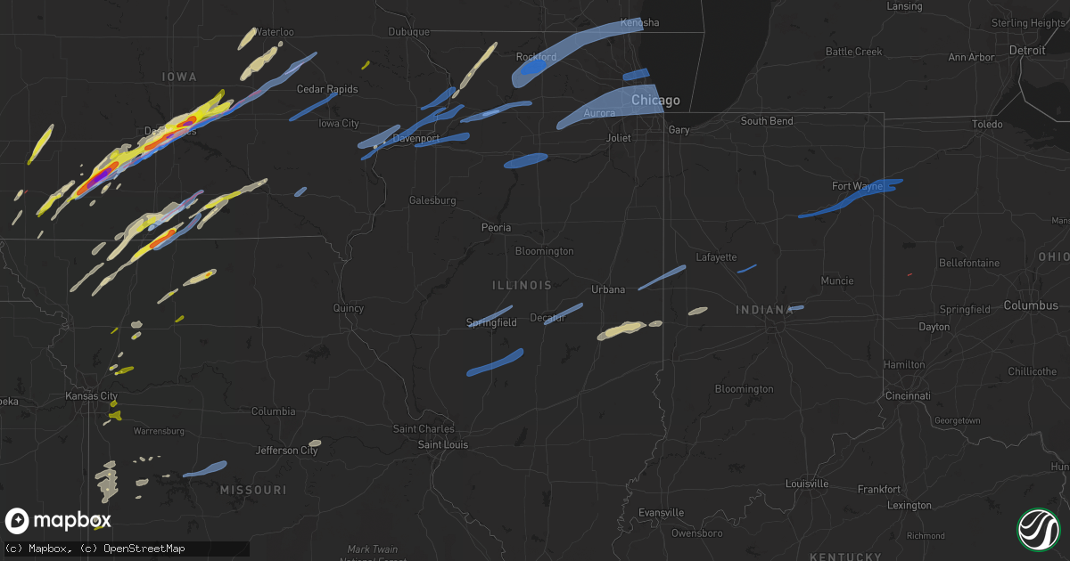
Hail Map in Illinois on March 5, 2022
Get this storm
March 5 map
$229
one time, instant access
Download today. No call, no setup
Keep the $229
Bought the map and want the full workflow? Apply the entire $229 to a subscription within 7 days. None of it is wasted.
Every map, not just this one
This buys you this map. Subscription and you get every map we run, in the markets you choose from a few cities to whole states to nationwide. Plus real-time alerts the moment a storm fires.
Contact data
Name, contact info, occupancy, even credit band for addresses in the footprint. You go from where it hit to who to call.
Become the source they trust
Unlimited branding weather history reports on demand. You already have the documented answer ready for the property owner, and you are the one who showed up with it.
Property data and RoofTrace estimates
Pull up any address you have got, its value and the exact code rules for that jurisdiction, straight from One Click Code. Then RoofTrace estimates the squares, pitch, and roof value, priced the way you price.
Storm reports in Illinois
Illinois
| Date | Description |
|---|---|
| 03/05/202211:50 AM CST | Power transformers down. Relayed via broadcast media. Time estimated from radar. |
| 03/05/20225:49 AM CST | At 1149 PM CST, a severe thunderstorm was located near Nokomis, moving east at 60 mph. HAZARD...70 mph wind gusts. SOURCE...Radar indicated. IMPACT...Expect considerable tree damage. Damage is likely to mobile homes, roofs, and outbuildings. This severe thunderstorm will be near... Cowden and Tower Hill around 1205 AM CST.Other locations in the path of this severe thunderstorm includeShelbyville.This includes Interstate 57 between mile markers 169 and 172. |
| 03/05/20225:31 AM CST | At 1131 PM CST, a severe thunderstorm was located over Moweaqua, or 14 miles northeast of Taylorville, moving east at 65 mph. HAZARD...60 mph wind gusts. SOURCE...Radar indicated. IMPACT...Expect damage to roofs, siding, and trees. This severe thunderstorm will be near... Bethany and Dalton City around 1145 PM CST. Lovington around 1150 PM CST.Other locations in the path of this severe thunderstorm includeHammond, Arthur and Atwood. |
| 03/05/20225:24 AM CST | At 1124 PM CST, a severe thunderstorm was located over Litchfield, moving east at 70 mph. HAZARD...60 mph wind gusts and quarter size hail. SOURCE...Radar indicated. IMPACT...Hail damage to vehicles is expected. Expect wind damage to roofs, siding, and trees. This severe thunderstorm will be near... Taylor Springs around 1130 PM CST. Hillsboro, Coffeen and Schram City around 1135 PM CST. Witt around 1140 PM CST.Other locations in the path of this severe thunderstorm includeNokomis.This includes Interstate 55 in Illinois between exits 52 and 63. This also includes Ramsey Lake State Park and Lake Lou Yaeger. |
| 03/05/20225:19 AM CST | At 1118 PM CST, a severe thunderstorm was located over Warrensburg, or 8 miles west of Decatur, moving northeast at 60 mph. HAZARD...60 mph wind gusts. SOURCE...Radar indicated. IMPACT...Expect damage to roofs, siding, and trees. This severe thunderstorm will be near... Decatur and Forsyth around 1125 PM CST. Maroa and Oreana around 1130 PM CST. Argenta around 1135 PM CST.Other locations in the path of this severe thunderstorm includeWeldon, Monticello and De Land.This includes the following highways... Interstate 72 between mile markers 128 and 169. Interstate 74 near mile marker 160. |
| 03/05/20224:59 AM CST | At 1058 PM CST, a severe thunderstorm was located over White Oak, or 9 miles east of Virden, moving east at 65 mph. HAZARD...60 mph wind gusts. SOURCE...Radar indicated. IMPACT...Expect damage to roofs, siding, and trees. This severe thunderstorm will be near... Kincaid, Bulpitt and Jeisyville around 1110 PM CST. Taylorville around 1115 PM CST.Other locations in the path of this severe thunderstorm includeStonington, Assumption, Blue Mound, Moweaqua and Macon.This includes the following highways... Interstate 55 between mile markers 77 and 83. Interstate 72 between mile markers 129 and 135. |
| 03/05/20224:52 AM CST | At 1052 PM CST, a severe thunderstorm was located near Jerseyville, moving east at 60 mph. HAZARD...60 mph wind gusts. SOURCE...Radar indicated. IMPACT...Expect damage to roofs, siding, and trees. This severe thunderstorm will be near... Shipman around 1105 PM CST. Bunker Hill around 1110 PM CST.Other locations in the path of this severe thunderstorm includeGillespie, Benld, Wilsonville, Sawyerville, Mount Clare, EastGillespie, Mount Olive and Eagarville.This includes Interstate 55 in Illinois near exit 44. This also includes Beaver Dam State Park. |
| 03/05/20224:52 AM CST | At 1052 PM CST, a severe thunderstorm was located over Riverton, or 7 miles northeast of Springfield, moving northeast at 65 mph. HAZARD...60 mph wind gusts. SOURCE...Radar indicated. IMPACT...Expect damage to roofs, siding, and trees. This severe thunderstorm will be near... Cornland around 1100 PM CST. Illiopolis around 1105 PM CST. Mount Pulaski and Latham around 1110 PM CST.This includes the following highways... Interstate 55 between mile markers 91 and 100. Interstate 72 between mile markers 97 and 129. |
| 03/05/20224:49 AM CST | At 1049 PM CST, a severe thunderstorm was located over Stanford, or 14 miles west of Bloomington, moving northeast at 65 mph. HAZARD...60 mph wind gusts. SOURCE...Radar indicated. IMPACT...Expect damage to roofs, siding, and trees. This severe thunderstorm will be near... Bloomington and Carlock around 1100 PM CST. Normal, Hudson and Towanda around 1105 PM CST.Other locations in the path of this severe thunderstorm includeLexington and Chenoa.This includes the following highways... Interstate 39 between mile markers 0 and 17. Interstate 55 between mile markers 151 and 187. Interstate 74 between mile markers 112 and 138. |
| 03/05/20224:35 AM CST | At 1035 PM CST, severe thunderstorms were located along a line extending from near Southern Lake Winnebago to near Slinger to Richmond, moving east at 45 mph. HAZARD...60 mph wind gusts. SOURCE...Radar indicated. IMPACT...Expect damage to roofs, siding, and trees. Locations impacted include... Milwaukee, Kenosha, Racine, Waukesha, West Allis, Sheboygan, Wauwatosa, Fond Du Lac, New Berlin, Brookfield, Greenfield, Menomonee Falls, Oak Creek, West Bend, Mount Pleasant, Muskego, Mequon, South Milwaukee, Pleasant Prairie and Cudahy. |
| 03/05/20224:32 AM CST | At 1031 PM CST, a severe thunderstorm was located near Kemper, moving northeast at 65 mph. HAZARD...60 mph wind gusts and quarter size hail. SOURCE...Radar indicated. IMPACT...Hail damage to vehicles is expected. Expect wind damage to roofs, siding, and trees. This severe thunderstorm will be near... Palmyra around 1040 PM CST. Carlinville around 1045 PM CST. Girard around 1050 PM CST.Other locations in the path of this severe thunderstorm includeVirden, Farmersville and White Oak. |
| 03/05/20224:26 AM CST | At 1026 PM CST, a severe thunderstorm was located near Green Valley, or 10 miles north of Mason City, moving northeast at 70 mph. HAZARD...60 mph wind gusts. SOURCE...Radar indicated. IMPACT...Expect damage to roofs, siding, and trees. This severe thunderstorm will be near... Delavan and Emden around 1030 PM CST. Tremont and Hopedale around 1040 PM CST. Mackinaw and Minier around 1045 PM CST.Other locations in the path of this severe thunderstorm includeGoodfield and Deer Creek.This includes the following highways... Interstate 155 between mile markers 8 and 27. Interstate 74 between mile markers 108 and 109. |
| 03/05/20224:25 AM CST | At 1025 PM CST, severe thunderstorms were located along a line extending from Palmyra to near Beloit, moving east at 55 mph. HAZARD...60 mph wind gusts. SOURCE...Radar indicated. IMPACT...Expect damage to roofs, siding, and trees. Locations impacted include... Beloit, Whitewater, Elkhorn, Delavan, Lake Geneva, Mukwonago, East Troy, Williams Bay, Genoa City, Walworth, Clinton, North Prairie, Palmyra, Fontana-On-Geneva Lake, Sharon, Darien, Como, Pell Lake, Potter Lake and Powers Lake. |
| 03/05/20224:14 AM CST | At 1014 PM CST, severe thunderstorms were located along a line extending from near Mendota to near Camp Grove, moving east at 55 mph. HAZARD...70 mph wind gusts. SOURCE...Radar indicated. IMPACT...Expect considerable tree damage. Damage is likely to mobile homes, roofs, and outbuildings. Severe thunderstorms will be near... Mendota around 1020 PM CST. Earlville around 1025 PM CST. Leland around 1030 PM CST. Sandwich, Lake Holiday and Somonauk around 1040 PM CST. Plano and Tonica around 1045 PM CST. Yorkville around 1050 PM CST. Oswego and Sugar Grove around 1055 PM CST. Aurora, Streator, Montgomery, Boulder Hill and Grand Ridge around 1100 PM CST.Other locations impacted by these severe thunderstorms includeMillbrook, Triumph, Ransom, Harding, Dayton, Prairie Center, Kinsman,South Wilmington, Bristol and East Brooklyn.Including the following interstates... I-39 between mile markers 41 and 77. I-55 between mile markers 220 and 233. I-80 between mile markers 74 and 122. I-88 between mile markers 111 and 119. |
| 03/05/20224:06 AM CST | At 1006 PM CST, a severe thunderstorm was located near Camp Grove, or 8 miles northwest of Lacon, moving east at 65 mph. HAZARD...60 mph wind gusts. SOURCE...Radar indicated. IMPACT...Expect damage to roofs, siding, and trees. This severe thunderstorm will be near... Sparland around 1010 PM CST. Lacon and Henry around 1015 PM CST. Varna around 1020 PM CST.Other locations in the path of this severe thunderstorm includeWenona.This includes Interstate 39 between mile markers 34 and 40. |
| 03/05/20224:03 AM CST | At 1003 PM CST, a severe thunderstorm was located over Bath, or 9 miles south of Havana, moving northeast at 60 mph. HAZARD...60 mph wind gusts. SOURCE...Radar indicated. IMPACT...Expect damage to roofs, siding, and trees. This severe thunderstorm will be near... Easton around 1020 PM CST.Other locations in the path of this severe thunderstorm include MasonCity and San Jose. |
| 03/05/20223:56 AM CST | At 955 PM CST, a severe thunderstorm was located over Wyanet, or 8 miles west of Princeton, moving east at 50 mph. HAZARD...60 mph wind gusts. SOURCE...Radar indicated. IMPACT...Expect damage to roofs, siding, and trees. This severe thunderstorm will be near... Princeton and Tiskilwa around 1005 PM CST. Hennepin, DePue and Bureau Junction around 1015 PM CST.Other locations in the path of this severe thunderstorm includeSpring Valley, Granville, Ladd and Dalzell. |
| 03/05/20223:40 AM CST | At 939 PM CST, a severe thunderstorm was located near Victoria, or 17 miles east of Galesburg, moving northeast at 65 mph. HAZARD...60 mph wind gusts. SOURCE...Radar indicated. IMPACT...Expect damage to roofs, siding, and trees. This severe thunderstorm will be near... West Jersey and La Fayette around 945 PM CST. Toulon around 950 PM CST. Wyoming and Elmira around 955 PM CST.Other locations in the path of this severe thunderstorm includeOsceola, Bradford, Castleton and Camp Grove. |
| 03/05/20223:33 AM CST | At 933 PM CST, a severe thunderstorm was located near Galva, or 7 miles southeast of Cambridge, moving east at 50 mph. HAZARD...60 mph wind gusts and quarter size hail. SOURCE...Radar indicated. IMPACT...Hail damage to vehicles is expected. Expect wind damage to roofs, siding, and trees. This severe thunderstorm will be near... Kewanee around 945 PM CST.Other locations in the path of this severe thunderstorm include Buda,Wyanet and Tiskilwa. |
| 03/05/20223:27 AM CST | At 926 PM CST, severe thunderstorms were located along a line extending from Pearl City to near Deer Grove, moving northeast at 65 mph. HAZARD...70 mph wind gusts. SOURCE...Radar indicated. IMPACT...Expect considerable tree damage. Damage is likely to mobile homes, roofs, and outbuildings. Severe thunderstorms will be near... Pearl City around 930 PM CST. Sterling and Lena around 935 PM CST. Freeport and Cedarville around 940 PM CST. Dakota, Rock City and Ridott around 945 PM CST.Other locations in the path of these severe thunderstorms includeDavis. |
| 03/05/20223:18 AM CST | At 917 PM CST, a severe thunderstorm was located 7 miles northwest of Abingdon, or 7 miles southeast of Monmouth, moving northeast at 55 mph. HAZARD...60 mph wind gusts. SOURCE...Radar indicated. IMPACT...Expect damage to roofs, siding, and trees. This severe thunderstorm will be near... Galesburg and Knoxville around 930 PM CST. Wataga around 935 PM CST.Other locations in the path of this severe thunderstorm includeOneida, Altona and Victoria.This includes Interstate 74 between mile markers 34 and 68. |
| 03/05/20223:08 AM CST | At 908 PM CST, a severe thunderstorm was located over Geneseo, or 12 miles north of Cambridge, moving east at 55 mph. HAZARD...60 mph wind gusts. SOURCE...Radar indicated. IMPACT...Expect damage to roofs, siding, and trees. This severe thunderstorm will be near... Atkinson around 915 PM CST. Annawan and Hooppole around 920 PM CST.Other locations in the path of this severe thunderstorm include DeerGrove and Walnut. |
| 03/05/20222:02 AM CST | At 802 PM CST, severe thunderstorms were located along a line extending from near Conesville to Winfield, moving east at 45 mph. HAZARD...60 mph wind gusts. SOURCE...Radar indicated. IMPACT...Expect damage to roofs, siding, and trees. Severe thunderstorms will be near... Conesville, Letts and Nichols around 805 PM CST. Fruitland and Morning Sun around 815 PM CST. Wapello, Grandview and Amber around 820 PM CST.Other locations in the path of these severe thunderstorms includeMuscatine, Fairport, Illinois City, Toolesboro, New Boston, Eliza andMannon. |
| 03/05/202212:45 AM CST | Large tree blown down and 12x6 foot trailer pushed over 100 feet. Social media report. |
| 03/05/202212:42 AM CST | 1 inch tree limbs broken; shingles blown off. |
| 03/05/202212:35 AM CST | A local report indicates 64 MPH wind near VERMILION REGIONAL AIRP |
| 03/05/202212:35 AM CST | A local report indicates 60 MPH wind near JAMAICA |
| 03/05/202212:33 AM CST | At 632 PM CST, a severe thunderstorm was located near Freeport, moving northeast at 60 mph. HAZARD...60 mph wind gusts and quarter size hail. SOURCE...Radar indicated. IMPACT...Hail damage to vehicles is expected. Expect wind damage to roofs, siding, and trees. This severe thunderstorm will be near... Dakota and Rock City around 645 PM CST. Davis around 650 PM CST. |
| 03/05/202212:30 AM CST | Wind blew down trees. Social media report. |
| 03/05/202212:28 AM CST | Swingset anchored 1 foot in ground lifted and blown 50 feet. |
| 03/05/202212:25 AM CST | Average hail size 0.75 inches... Largest hail stone 1.25 inches. Lasted 5 minutes. |
| 03/05/202212:16 AM CST | Large tree uprooted. |
| 03/05/202212:15 AM CST | 4 large power poles blown down near 1800n and 1500e intersection. |
| 03/05/202212:05 AM CST | Powerpoles blown down. |
| 03/04/202211:55 PM CST | Trees uprooted and powerpoles blown down. |
| 03/04/202211:55 PM CST | Tree blown down on road hitting a car with another car running into the tree on road. Report by sheriff's office. |
| 03/04/202211:50 PM CST | Corrects previous tstm wnd dmg report from rantoul. Power transformers down. Relayed via broadcast media. Time estimated from radar. |
| 03/04/202211:48 PM CST | A local report indicates 59 MPH wind near 3 NW KIRKSVILLE |
| 03/04/202211:45 PM CST | Corrects previous non-tstm wnd dmg report from elsah. Damage to anchored outside play structures |
| 03/04/202211:38 PM CST | Asos station kdec decatur ap. |
| 03/04/202211:26 PM CST | Kmdw asos peak gust. |
| 03/04/202211:22 PM CST | Large tree limb downed. Time estimated by radar. |
| 03/04/202211:21 PM CST | Estimated peak wind gust. |
| 03/04/202211:20 PM CST | Winds picked up and blew an anchored swingset 12 feet. Social media report. |
| 03/04/202211:20 PM CST | Large tree limb downed onto road. Time estimated from radar. |
| 03/04/202211:17 PM CST | Photo shared on social media showing part of an apartment complex roof peeled back. Time estimated from radar. |
| 03/04/202211:15 PM CST | Awos station ktaz taylorville muni ap. |
| 03/04/202211:14 PM CST | Estimated 50-60 mph wind gusts in elk grove village. |
| 03/04/202211:12 PM CST | Kugn asos peak gust. |
| 03/04/202211:11 PM CST | Kpwk asos peak gust. |
| 03/04/202211:00 PM CST | Measured on personal weather station. |
| 03/04/202210:59 PM CST | Corrects previous non-tstm wnd gst report from 1 ene bloomington. Mesonet station cw3379 bloomington. |
| 03/04/202210:55 PM CST | Kdpa asos peak gust. |
| 03/04/202210:52 PM CST | Semi blown over on i-55 just north of waggoner at mile marker 68. |
| 03/04/202210:45 PM CST | Karr asos peak gust. |
| 03/04/202210:45 PM CST | Mesonet station imc03 crystal lake |
| 03/04/202210:44 PM CST | 8-inch diameter tree limb downed. Time estimated from radar. |
| 03/04/202210:43 PM CST | Asos station kspi springfield capital ap. |
| 03/04/202210:40 PM CST | 66 mph wind gust near west side christian church on veterans parkway. |
| 03/04/202210:36 PM CST | Utility poles were damaged near walnut street and portland avenue. |
| 03/04/202210:36 PM CST | Measured at tazewell county eoc. |
| 03/04/202210:35 PM CST | Peak gust from weatherbug station in harvard. |
| 03/04/202210:35 PM CST | Kvys awos peak gust. |
| 03/04/202210:25 PM CST | Semi truck blown over on route 72 east of genoa. Time estimated from radar. |
| 03/04/202210:25 PM CST | Mesonet station imc02 marengo 5 nw |
| 03/04/202210:18 PM CST | Photo shared on social media of a tree blown down... Partially on a house. |
| 03/04/202210:15 PM CST | Krfd asos peak gust. |
| 03/04/202210:15 PM CST | Tree limbs and power lines were blown down in rockford... Along with a few full trees. Damage was described as scattered. |
| 03/04/202210:15 PM CST | Irrigation system blown over. |
| 03/04/20229:55 PM CST | A local report indicates 68 MPH wind near FREEPORT ALBERTUS |
| 03/04/20229:45 PM CST | Photo shared on social media of part of a fence blown down. |
| 03/04/20229:37 PM CST | Time estimated from radar. Trees down along dixon road. |
| 03/04/20229:35 PM CST | A local report indicates 60 MPH wind near 2 W MOUNT STERLING |
| 03/04/20229:34 PM CST | Awos. |
| 03/04/20229:30 PM CST | Structural damage to a downtown building... Multiple tree limbs down... Sporadic power outages. |
| 03/04/20229:28 PM CST | From hand-held anemometer. |
| 03/04/20229:22 PM CST | A local report indicates 65 MPH wind near MOUNT CARROLL |
| 03/04/20229:09 PM CST | Spotter reported a flipped carport... Was not at home at the time. Time of the event estimated using radar. |
| 03/04/20228:56 PM CST | Quincy airport asos. |
| 03/04/20228:50 PM CST | Corrects previous tstm wnd dmg report from 1 wnw aledo. |
| 03/04/20228:50 PM CST | Also pea sized hail. |
| 03/04/20228:48 PM CST | Asos. |
Cities Impacted by Hail Map on March 5, 2022
- Bondurant, IA
- Prole, IA
- Baxter, IA
- Mitchellville, IA
- Ira, IA
- Van Meter, IA
- Fontanelle, IA
- Norwalk, IA
- Winterset, IA
- Newton, IA
- Berwick, IA
- Carlisle, IA
- Windsor Heights, IA
- Waukee, IA
- Runnells, IA
- Cumming, IA
- Maxwell, IA
- Earlham, IA
- Prescott, IA
- Orient, IA
- Dexter, IA
- Creston, IA
- Altoona, IA
- Des Moines, IA
- Ankeny, IA
- Corning, IA
- Colfax, IA
- Pleasant Hill, IA
- Mingo, IA
- West Des Moines, IA
- Greenfield, IA
- Garwin, IA
- Gladbrook, IA
- Traer, IA
- Toledo, IA
- Seneca, KS
- Centralia, KS
- Villisca, IA
- Stanton, IA
- Clarinda, IA
- Essex, IA
- Red Oak, IA
- Nodaway, IA
- Laurel, IA
- Gilman, IA
- Kellogg, IA
- Butler, MO
- Bridgewater, IA
- Onaga, KS
- Vermillion, KS
- Frankfort, KS
- Bolckow, MO
- Gentry, MO
- Guilford, MO
- Stanberry, MO
- Conception, MO
- Appleton City, MO
- Promise City, IA
- Plano, IA
- Lenox, IA
- Eagleville, MO
- Ridgeway, MO
- Blythedale, MO
- Leon, IA
- Merrimac, WI
- Lodi, WI
- Decatur, IA
- Amsterdam, MO
- Amoret, MO
- Adrian, MO
- Rich Hill, MO
- Greenwood, MO
- Lees Summit, MO
- Shannon, IL
- Freeport, IL
- Lanark, IL
- Pearl City, IL
- Malvern, IA
- Emerson, IA
- Hastings, IA
- Montrose, MO
- Clinton, MO
- Corydon, IA
- Riverton, IA
- Imogene, IA
- Sidney, IA
- Farragut, IA
- Muscatine, IA
- King City, MO
- Cainsville, MO
- Davis City, IA
- Lineville, IA
- Fulton, IL
- Thomson, IL
- Excelsior Springs, MO
- Urich, MO
- Creighton, MO
- Ottumwa, IA
- Waterloo, IA
- La Porte City, IA
- Allerton, IA
- Bethany, MO
- Mount Ayr, IA
- Hatfield, MO
- Lamoni, IA
- Grand River, IA
- Grant City, MO
- Kellerton, IA
- Denver, MO
- Colo, IA
- Oakland, IL
- Newman, IL
- Camargo, IL
- Arcola, IL
- Tuscola, IL
- Hindsboro, IL
- Trenton, MO
- Melrose, IA
- Marshall, IN
- Marne, IA
- Walnut, IA
- Hancock, IA
- Pardeeville, WI
- Reinbeck, IA
- Buckingham, IA
- Hudson, IA
- Cambria, WI
- Portage, WI
- Poynette, WI
- Baraboo, WI
- Prairie Du Sac, WI
- Wyocena, WI
- Savanna, IL
- Dakota, IL
- Cedarville, IL
- Chadwick, IL
- Mount Carroll, IL
- Patterson, IA
- Melbourne, IA
- Rhodes, IA
- Clive, IA
- Macksburg, IA
- Urbandale, IA
- Prairie City, IA
- Stuart, IA
- Bonnots Mill, MO
- Chamois, MO
- Darlington, MO
- Albany, MO
- Franklin, MO
- Jamesport, MO
- Raymore, MO
- Weldon, IA
- Garden Grove, IA
- Humeston, IA
- Markesan, WI
- Van Wert, IA
- Worth, MO
- Kearney, MO
- Elk Horn, IA
- Humboldt, IL
- Chrisman, IL
- Hume, IL
- Metcalf, IL
- Brocton, IL
- Albia, IA
- Moravia, IA
- Galt, MO
- Humphreys, MO
- Milan, MO
- Dike, IA
- Cedar Falls, IA
- Grundy Center, IA
- Haverhill, IA
- Booneville, IA
- Pollock, MO
- Audubon, IA
- Kimballton, IA
- Russell, IA
- Randolph, WI
- Archie, MO
- Dysart, IA
- Sheridan, MO
- Chillicothe, IA
- Eddyville, IA
- Dana, IN
- Westmoreland, KS
- Massena, IA
- Blakesburg, IA
- Seymour, IA
- Mystic, IA
- Olsburg, KS
- Chariton, IA
- Blairstown, MO
- Richards, MO
- Chilhowee, MO
- Coin, IA
- Blanchard, IA
- Waveland, IN
- Hamilton, MO
- Kidder, MO
- Kingston, MO
- Oakland, IA
- Exira, IA
- Redding, IA
- Derby, IA
- Woodburn, IA
- Avoca, IA
- Lawson, MO
- Afton, IA
- New Hampton, MO
- Martinsville, MO
- Bloomingdale, IN
- Crawfordsville, IN
- Grinnell, IA
- Garrison, IA
- Mount Auburn, IA
- Clutier, IA
- Tama, IA
- Vining, IA
- Center Point, IA
- Elberon, IA
- Keystone, IA
- Chelsea, IA
- Walker, IA
- Vinton, IA
- Urbana, IA
- Van Horne, IA
- Indianola, IA
- Clio, IA
- Mercer, MO
- Cedar Rapids, IA
- Williamsburg, IA
- Amana, IA
- Marengo, IA
- Middle Amana, IA
- Fairfax, IA
- South Amana, IA
- Homestead, IA
- Ely, IA
- Conroy, IA
- Swisher, IA
- Fairfield, IA
- Libertyville, IA
- Batavia, IA
- Walcott, IA
- Davenport, IA
- Blue Grass, IA
- Camanche, IA
- Stockton, IA
- Princeton, IA
- Morrison, IL
- Albany, IL
- Letts, IA
- Erie, IL
- Long Grove, IA
- Le Claire, IA
- Fenton, IL
- Fruitland, IA
- Cordova, IL
- Eldridge, IA
- Wilton, IA
- Atalissa, IA
- Nichols, IA
- Moscow, IA
- West Liberty, IA
- Durant, IA
- De Witt, IA
- Clinton, IA
- Lincoln, MO
- Warsaw, MO
- Cole Camp, MO
- Versailles, MO
- Stover, MO
- Antwerp, OH
- Monroeville, IN
- Paulding, OH
- Hoagland, IN
- Fort Wayne, IN
- Lagro, IN
- Woodburn, IN
- New Haven, IN
- Ossian, IN
- Yoder, IN
- Markle, IN
- Payne, OH
- Huntington, IN
- Roanoke, IN
- Wabash, IN
- Zanesville, IN
- Andrews, IN
- Ingalls, IN
- Indianapolis, IN
- Fishers, IN
- Mccordsville, IN
- Fortville, IN
- Frankfort, IN
- Michigantown, IN
- Versailles, OH
- Marshalltown, IA
- Monticello, IA
- Sauk City, WI
- Cameron, MO
- Rayville, MO
- Chillicothe, MO
- Grain Valley, MO
- Moundville, MO
- Nevada, MO
- Deerfield, MO
- Blue Springs, MO
- Prophetstown, IL
- Rock Island, IL
- Silvis, IL
- Coal Valley, IL
- Moline, IL
- Milan, IL
- Geneseo, IL
- Carbon Cliff, IL
- East Moline, IL
- Colona, IL
- Rock Falls, IL
- Lyndon, IL
- Dixon, IL
- Franklin Grove, IL
- Ashton, IL
- Tampico, IL
- Harmon, IL
- Sterling, IL
- Genoa City, WI
- Loves Park, IL
- Mount Morris, IL
- Byron, IL
- Capron, IL
- Zion, IL
- Twin Lakes, WI
- Kenosha, WI
- Belvidere, IL
- Poplar Grove, IL
- Monroe Center, IL
- Hebron, IL
- Wilmot, WI
- Ringwood, IL
- Rockford, IL
- Stillman Valley, IL
- Spring Grove, IL
- Burlington, WI
- Caledonia, IL
- Silver Lake, WI
- Salem, WI
- Pleasant Prairie, WI
- Leaf River, IL
- Oregon, IL
- Wonder Lake, IL
- Cherry Valley, IL
- Marengo, IL
- Chana, IL
- Garden Prairie, IL
- Woodstock, IL
- Lake Geneva, WI
- Bristol, WI
- Richmond, IL
- Antioch, IL
- Harvard, IL
- Walworth, WI
- Trevor, WI
- Winnebago, IL
- Davis Junction, IL
- Lake Mills, WI
- Edgerton, WI
- Oregon, WI
- Brooklyn, WI
- Cambridge, WI
- Fort Atkinson, WI
- Stoughton, WI
- Jefferson, WI
- Milwaukee, WI
- Brookfield, WI
- Mukwonago, WI
- North Prairie, WI
- New Berlin, WI
- Waukesha, WI
- Elm Grove, WI
- Dalzell, IL
- Granville, IL
- Oglesby, IL
- Princeton, IL
- Peru, IL
- Hennepin, IL
- Depue, IL
- Spring Valley, IL
- Utica, IL
- Bureau, IL
- La Salle, IL
- Tiskilwa, IL
- Mark, IL
- Sherman, IL
- Buffalo, IL
- Springfield, IL
- Pleasant Plains, IL
- Riverton, IL
- Elkhart, IL
- Williamsville, IL
- New Berlin, IL
- Sugar Grove, IL
- Berkeley, IL
- Melrose Park, IL
- Woodridge, IL
- Lombard, IL
- Cicero, IL
- Itasca, IL
- Glen Ellyn, IL
- Hines, IL
- Montgomery, IL
- Hinckley, IL
- Saint Charles, IL
- Maywood, IL
- Berwyn, IL
- Willowbrook, IL
- Warrenville, IL
- Roselle, IL
- Westchester, IL
- Hanover Park, IL
- Brookfield, IL
- Winfield, IL
- Summit Argo, IL
- Bensenville, IL
- Sandwich, IL
- Big Rock, IL
- Chicago, IL
- Yorkville, IL
- Medinah, IL
- Waterman, IL
- Downers Grove, IL
- Clarendon Hills, IL
- Darien, IL
- Naperville, IL
- Lyons, IL
- Wood Dale, IL
- Bloomingdale, IL
- Mooseheart, IL
- Park Ridge, IL
- Batavia, IL
- Lisle, IL
- Geneva, IL
- Bellwood, IL
- Elmwood Park, IL
- Elmhurst, IL
- Aurora, IL
- North Aurora, IL
- Stone Park, IL
- Oak Brook, IL
- Glendale Heights, IL
- Lincolnwood, IL
- Leland, IL
- Addison, IL
- Skokie, IL
- Hinsdale, IL
- Schiller Park, IL
- River Forest, IL
- Wayne, IL
- Carol Stream, IL
- Elk Grove Village, IL
- Burbank, IL
- Des Plaines, IL
- Riverside, IL
- Wheaton, IL
- Oswego, IL
- Western Springs, IL
- Willow Springs, IL
- Bristol, IL
- Forest Park, IL
- Plano, IL
- Westmont, IL
- La Grange Park, IL
- River Grove, IL
- Oak Park, IL
- Broadview, IL
- Somonauk, IL
- La Grange, IL
- Bartlett, IL
- Bolingbrook, IL
- Franklin Park, IL
- West Chicago, IL
- Villa Park, IL
- Justice, IL
- Bridgeview, IL
- Niles, IL
- Harwood Heights, IL
- Elburn, IL
- Hillside, IL
- Kenilworth, IL
- Palatine, IL
- Rolling Meadows, IL
- Glenview, IL
- Wilmette, IL
- Glencoe, IL
- Mount Prospect, IL
- Arlington Heights, IL
- Northbrook, IL
- Prospect Heights, IL
- Winnetka, IL
- Wheeling, IL
- Highland Park, IL
- Morrisonville, IL
- Carlinville, IL
- Farmersville, IL
- Waggoner, IL
- Palmer, IL
- Girard, IL
- Taylorville, IL
- Harvel, IL
- Decatur, IL
- Bement, IL
- Cerro Gordo, IL
- Argenta, IL
- Milmine, IL
- Fithian, IL
- Oakwood, IL
- Attica, IN
- West Lebanon, IN
- Danville, IL
- Williamsport, IN
- Bismarck, IL


