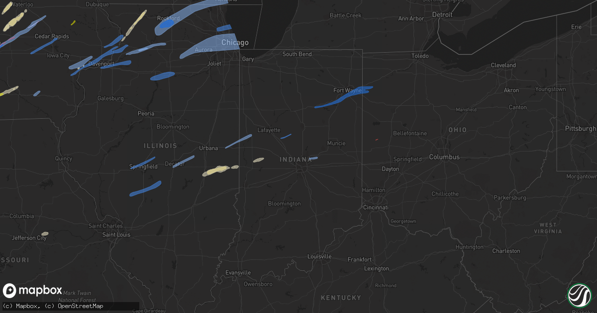
Hail Map in Indiana on March 5, 2022
Get this storm
March 5 map
$229
one time, instant access
Download today. No call, no setup
Keep the $229
Bought the map and want the full workflow? Apply the entire $229 to a subscription within 7 days. None of it is wasted.
Every map, not just this one
This buys you this map. Subscription and you get every map we run, in the markets you choose from a few cities to whole states to nationwide. Plus real-time alerts the moment a storm fires.
Contact data
Name, contact info, occupancy, even credit band for addresses in the footprint. You go from where it hit to who to call.
Become the source they trust
Unlimited branding weather history reports on demand. You already have the documented answer ready for the property owner, and you are the one who showed up with it.
Property data and RoofTrace estimates
Pull up any address you have got, its value and the exact code rules for that jurisdiction, straight from One Click Code. Then RoofTrace estimates the squares, pitch, and roof value, priced the way you price.
Storm reports in Indiana
Indiana
| Date | Description |
|---|---|
| 03/05/20225:56 AM CST | At 1156 PM CST, a severe thunderstorm was located near Allenville, or near Sullivan, moving east at 65 mph. HAZARD...70 mph wind gusts. SOURCE...Radar indicated. IMPACT...Expect considerable tree damage. Damage is likely to mobile homes, roofs, and outbuildings. This severe thunderstorm will be near... Cooks Mill around 1200 AM CST. Arcola and Humboldt around 1205 AM CST. Hindsboro and Rardin around 1215 AM CST.Other locations in the path of this severe thunderstorm includeOakland, Newman, Brocton, Hume, Redmon, Paris and Chrisman.This includes the following highways... Interstate 57 between mile markers 181 and 223. Interstate 70 between mile markers 136 and 154. |
| 03/05/20225:38 AM CST | At 1138 PM CST, a severe thunderstorm was located over Mahomet, or 10 miles northwest of Champaign, moving east at 65 mph. HAZARD...60 mph wind gusts. SOURCE...Radar indicated. IMPACT...Expect damage to roofs, siding, and trees. This severe thunderstorm will be near... Champaign and Fisher around 1145 PM CST. Urbana and Thomasboro around 1150 PM CST. Rantoul around 1155 PM CST.Other locations in the path of this severe thunderstorm includeGifford, Potomac, Rankin, Rossville and Hoopeston.This includes the following highways... Interstate 57 between mile markers 222 and 257. Interstate 72 between mile markers 170 and 182. Interstate 74 between mile markers 164 and 220. |
| 03/05/20225:09 AM CST | At 1108 PM CST, severe thunderstorms were located along a line extending from Boulder Hill to near Seneca, moving east at 55 mph. HAZARD...70 mph wind gusts. SOURCE...Radar indicated. IMPACT...Expect considerable tree damage. Damage is likely to mobile homes, roofs, and outbuildings. Severe thunderstorms will be near... Plainfield around 1115 PM CST. Romeoville around 1120 PM CST. Bolingbrook, Woodridge and Lemont around 1125 PM CST. Braidwood, Coal City, Willow Springs and Diamond around 1130 PM CST. Palos Hills, Wilmington, Bridgeview, Chicago Ridge, Hickory Hills, Palos Heights, Worth and Lakewood Shores around 1135 PM CST. Oak Lawn, Burbank and Ashburn around 1140 PM CST. Englewood, Roseland, Auburn Gresham, Evergreen Park and Manhattan around 1145 PM CST. South Shore, Chatham and South Deering around 1150 PM CST. |
| 03/05/20223:22 AM CST | Several trees downed along reed road north of versailles. Time estimated by radar. |
| 03/05/20222:45 AM CST | Play set and trampoline blown over. Time estimated from radar. |
| 03/05/20222:37 AM CST | Poles down at intersection of county roads 650 east and 500 north. |
| 03/05/20222:35 AM CST | Report from mping: trees uprooted or snapped. |
| 03/05/20222:35 AM CST | Trees down. Time estimated from radar. |
| 03/05/20222:30 AM CST | Large... Approx 60x100 ft... Machine shed destroyed. Time estimated from radar. |
| 03/05/20222:30 AM CST | Report from mping: 3-inch tree limbs broken; power poles broken. |
| 03/05/20222:29 AM CST | Large evergreen tree uprooted. Numerous other branches down. |
| 03/05/20222:25 AM CST | Multiple 3+ inch diameter branches broken. Time estimated from radar. |
| 03/05/20222:25 AM CST | Grain bin dented. Time estimated from radar. |
| 03/05/20222:25 AM CST | Trampoline parts piercing through garage wall. |
| 03/05/20222:21 AM CST | Section of wooden fence blown down. |
| 03/05/20222:21 AM CST | A local report indicates 59 MPH wind near 4 NNW NEW HAVEN |
| 03/05/20222:20 AM CST | Uprooted large pine tree. Time estimated from radar. |
| 03/05/20222:20 AM CST | Door with framing flew into a car. Door was not from the same property as the car. Time estimated from radar. |
| 03/05/20222:20 AM CST | Tree fell on house. Time estimated from radar. |
| 03/05/20222:20 AM CST | Many shingles off of roofs and bits of siding ripped from houses. Minor tree damage with about 0.5 inch branches snapped off. Time estimated from radar. |
| 03/05/20222:20 AM CST | Large tree uprooted. Time estimated from radar. |
| 03/05/20222:19 AM CST | Power pole down on sr 5 just south of us 224. |
| 03/05/20222:19 AM CST | A local report indicates 60 MPH wind near POE |
| 03/05/20222:16 AM CST | A local report indicates 67 MPH wind near 2 ENE NINE MILE |
| 03/05/20222:15 AM CST | Large tree snapped. |
| 03/05/20222:15 AM CST | Porch pillars blown off of house... Piece of barn siding blown off... Large tree branches snapped. Time estimated from radar. |
| 03/05/20222:15 AM CST | A local report indicates 68 MPH wind near 2 S BOWERSTOWN |
| 03/05/20222:10 AM CST | Call from fort wayne dispatch reporting power flashes and several reports of tree damage from around the county. |
| 03/05/20222:05 AM CST | Siding and insulation removed from house. Time estimated from radar. |
| 03/05/20222:04 AM CST | Some siding ripped off of houses. Report via twitter... Time estimated from radar. |
| 03/05/20222:00 AM CST | Roof of building torn off. Time estimated from radar. |
| 03/05/20222:00 AM CST | Trees down in zionsville area. Time estimated from radar. |
| 03/05/20222:00 AM CST | Pool destroyed. Time estimated from radar. |
| 03/05/20222:00 AM CST | Lean-to style airplane hangar and anchoring posts destroyed. Time estimated from radar. |
| 03/05/20221:45 AM CST | Late report. Powerlines down. Time estimated by radar. |
| 03/05/20221:40 AM CST | Trees down in 600 block of south east st. And 600 block of south evans st. In lebanon. |
| 03/05/20221:35 AM CST | At kfkr frankfort municipal airport. |
| 03/05/20221:35 AM CST | A tree fell on two cars... Damaging them. Time estimated from radar. |
| 03/05/20221:30 AM CST | Tree fell on parked vehicle. Time estimated from radar. |
| 03/05/20221:29 AM CST | Measured at galveston airport. Relayed by wlfi. |
| 03/05/20221:29 AM CST | Mesonet station in004 2.6 nw argos |
| 03/05/20221:25 AM CST | One grain bin destroyed and three others damaged. Time estimated from radar. |
| 03/05/20221:25 AM CST | Tree fell on power lines. Time estimated from radar. |
| 03/05/20221:22 AM CST | A local report indicates 58 MPH wind near LOGANSPORT |
| 03/05/20221:20 AM CST | Multiple large uprooted trees. Time estimated from radar. |
| 03/05/20221:20 AM CST | Carport blown over. Was anchored 3 feet in ground. |
| 03/05/20221:15 AM CST | At county roads 500 north and 225 east. Also hail about 0.5 inches in diameter lasted about 5 minutes. |
| 03/05/20221:15 AM CST | Trees and power lines down across montgomery co. Time estimated from radar. |
| 03/05/20221:10 AM CST | 5 broken power poles. Time estimated from radar. |
| 03/05/20221:05 AM CST | Few trees down in the area. Time estimated from radar. |
| 03/05/20221:03 AM CST | Trees and power lines down across northern part of the county. Times estimated from radar. |
| 03/05/20221:00 AM CST | Tree snapped over house with damage to roof. Time estimated from radar. |
| 03/05/202212:54 AM CST | Relayed by wlfi. |
| 03/05/202212:52 AM CST | Trees down across vermillion co. One light pole down. Times estimated from radar. |
| 03/05/202212:45 AM CST | Peak gust via davis weather station. |
| 03/05/202212:45 AM CST | Report from mping: 1-inch tree limbs broken; shingles blown off. |
| 03/05/202212:40 AM CST | Nine large trees uprooted. |
| 03/05/202212:39 AM CST | Peak gust at kentland airport. |
| 03/05/202212:30 AM CST | Numerous trees/large branches down in a pile over a road. Time estimated from radar. |
| 03/05/202212:30 AM CST | Large tree split. Time estimated from radar. |
Cities Impacted by Hail Map on March 5, 2022
- Bondurant, IA
- Prole, IA
- Baxter, IA
- Mitchellville, IA
- Ira, IA
- Van Meter, IA
- Fontanelle, IA
- Norwalk, IA
- Winterset, IA
- Newton, IA
- Berwick, IA
- Carlisle, IA
- Windsor Heights, IA
- Waukee, IA
- Runnells, IA
- Cumming, IA
- Maxwell, IA
- Earlham, IA
- Prescott, IA
- Orient, IA
- Dexter, IA
- Creston, IA
- Altoona, IA
- Des Moines, IA
- Ankeny, IA
- Corning, IA
- Colfax, IA
- Pleasant Hill, IA
- Mingo, IA
- West Des Moines, IA
- Greenfield, IA
- Garwin, IA
- Gladbrook, IA
- Traer, IA
- Toledo, IA
- Seneca, KS
- Centralia, KS
- Villisca, IA
- Stanton, IA
- Clarinda, IA
- Essex, IA
- Red Oak, IA
- Nodaway, IA
- Laurel, IA
- Gilman, IA
- Kellogg, IA
- Butler, MO
- Bridgewater, IA
- Onaga, KS
- Vermillion, KS
- Frankfort, KS
- Bolckow, MO
- Gentry, MO
- Guilford, MO
- Stanberry, MO
- Conception, MO
- Appleton City, MO
- Promise City, IA
- Plano, IA
- Lenox, IA
- Eagleville, MO
- Ridgeway, MO
- Blythedale, MO
- Leon, IA
- Merrimac, WI
- Lodi, WI
- Decatur, IA
- Amsterdam, MO
- Amoret, MO
- Adrian, MO
- Rich Hill, MO
- Greenwood, MO
- Lees Summit, MO
- Shannon, IL
- Freeport, IL
- Lanark, IL
- Pearl City, IL
- Malvern, IA
- Emerson, IA
- Hastings, IA
- Montrose, MO
- Clinton, MO
- Corydon, IA
- Riverton, IA
- Imogene, IA
- Sidney, IA
- Farragut, IA
- Muscatine, IA
- King City, MO
- Cainsville, MO
- Davis City, IA
- Lineville, IA
- Fulton, IL
- Thomson, IL
- Excelsior Springs, MO
- Urich, MO
- Creighton, MO
- Ottumwa, IA
- Waterloo, IA
- La Porte City, IA
- Allerton, IA
- Bethany, MO
- Mount Ayr, IA
- Hatfield, MO
- Lamoni, IA
- Grand River, IA
- Grant City, MO
- Kellerton, IA
- Denver, MO
- Colo, IA
- Oakland, IL
- Newman, IL
- Camargo, IL
- Arcola, IL
- Tuscola, IL
- Hindsboro, IL
- Trenton, MO
- Melrose, IA
- Marshall, IN
- Marne, IA
- Walnut, IA
- Hancock, IA
- Pardeeville, WI
- Reinbeck, IA
- Buckingham, IA
- Hudson, IA
- Cambria, WI
- Portage, WI
- Poynette, WI
- Baraboo, WI
- Prairie Du Sac, WI
- Wyocena, WI
- Savanna, IL
- Dakota, IL
- Cedarville, IL
- Chadwick, IL
- Mount Carroll, IL
- Patterson, IA
- Melbourne, IA
- Rhodes, IA
- Clive, IA
- Macksburg, IA
- Urbandale, IA
- Prairie City, IA
- Stuart, IA
- Bonnots Mill, MO
- Chamois, MO
- Darlington, MO
- Albany, MO
- Franklin, MO
- Jamesport, MO
- Raymore, MO
- Weldon, IA
- Garden Grove, IA
- Humeston, IA
- Markesan, WI
- Van Wert, IA
- Worth, MO
- Kearney, MO
- Elk Horn, IA
- Humboldt, IL
- Chrisman, IL
- Hume, IL
- Metcalf, IL
- Brocton, IL
- Albia, IA
- Moravia, IA
- Galt, MO
- Humphreys, MO
- Milan, MO
- Dike, IA
- Cedar Falls, IA
- Grundy Center, IA
- Haverhill, IA
- Booneville, IA
- Pollock, MO
- Audubon, IA
- Kimballton, IA
- Russell, IA
- Randolph, WI
- Archie, MO
- Dysart, IA
- Sheridan, MO
- Chillicothe, IA
- Eddyville, IA
- Dana, IN
- Westmoreland, KS
- Massena, IA
- Blakesburg, IA
- Seymour, IA
- Mystic, IA
- Olsburg, KS
- Chariton, IA
- Blairstown, MO
- Richards, MO
- Chilhowee, MO
- Coin, IA
- Blanchard, IA
- Waveland, IN
- Hamilton, MO
- Kidder, MO
- Kingston, MO
- Oakland, IA
- Exira, IA
- Redding, IA
- Derby, IA
- Woodburn, IA
- Avoca, IA
- Lawson, MO
- Afton, IA
- New Hampton, MO
- Martinsville, MO
- Bloomingdale, IN
- Crawfordsville, IN
- Grinnell, IA
- Garrison, IA
- Mount Auburn, IA
- Clutier, IA
- Tama, IA
- Vining, IA
- Center Point, IA
- Elberon, IA
- Keystone, IA
- Chelsea, IA
- Walker, IA
- Vinton, IA
- Urbana, IA
- Van Horne, IA
- Indianola, IA
- Clio, IA
- Mercer, MO
- Cedar Rapids, IA
- Williamsburg, IA
- Amana, IA
- Marengo, IA
- Middle Amana, IA
- Fairfax, IA
- South Amana, IA
- Homestead, IA
- Ely, IA
- Conroy, IA
- Swisher, IA
- Fairfield, IA
- Libertyville, IA
- Batavia, IA
- Walcott, IA
- Davenport, IA
- Blue Grass, IA
- Camanche, IA
- Stockton, IA
- Princeton, IA
- Morrison, IL
- Albany, IL
- Letts, IA
- Erie, IL
- Long Grove, IA
- Le Claire, IA
- Fenton, IL
- Fruitland, IA
- Cordova, IL
- Eldridge, IA
- Wilton, IA
- Atalissa, IA
- Nichols, IA
- Moscow, IA
- West Liberty, IA
- Durant, IA
- De Witt, IA
- Clinton, IA
- Lincoln, MO
- Warsaw, MO
- Cole Camp, MO
- Versailles, MO
- Stover, MO
- Antwerp, OH
- Monroeville, IN
- Paulding, OH
- Hoagland, IN
- Fort Wayne, IN
- Lagro, IN
- Woodburn, IN
- New Haven, IN
- Ossian, IN
- Yoder, IN
- Markle, IN
- Payne, OH
- Huntington, IN
- Roanoke, IN
- Wabash, IN
- Zanesville, IN
- Andrews, IN
- Ingalls, IN
- Indianapolis, IN
- Fishers, IN
- Mccordsville, IN
- Fortville, IN
- Frankfort, IN
- Michigantown, IN
- Versailles, OH
- Marshalltown, IA
- Monticello, IA
- Sauk City, WI
- Cameron, MO
- Rayville, MO
- Chillicothe, MO
- Grain Valley, MO
- Moundville, MO
- Nevada, MO
- Deerfield, MO
- Blue Springs, MO
- Prophetstown, IL
- Rock Island, IL
- Silvis, IL
- Coal Valley, IL
- Moline, IL
- Milan, IL
- Geneseo, IL
- Carbon Cliff, IL
- East Moline, IL
- Colona, IL
- Rock Falls, IL
- Lyndon, IL
- Dixon, IL
- Franklin Grove, IL
- Ashton, IL
- Tampico, IL
- Harmon, IL
- Sterling, IL
- Genoa City, WI
- Loves Park, IL
- Mount Morris, IL
- Byron, IL
- Capron, IL
- Zion, IL
- Twin Lakes, WI
- Kenosha, WI
- Belvidere, IL
- Poplar Grove, IL
- Monroe Center, IL
- Hebron, IL
- Wilmot, WI
- Ringwood, IL
- Rockford, IL
- Stillman Valley, IL
- Spring Grove, IL
- Burlington, WI
- Caledonia, IL
- Silver Lake, WI
- Salem, WI
- Pleasant Prairie, WI
- Leaf River, IL
- Oregon, IL
- Wonder Lake, IL
- Cherry Valley, IL
- Marengo, IL
- Chana, IL
- Garden Prairie, IL
- Woodstock, IL
- Lake Geneva, WI
- Bristol, WI
- Richmond, IL
- Antioch, IL
- Harvard, IL
- Walworth, WI
- Trevor, WI
- Winnebago, IL
- Davis Junction, IL
- Lake Mills, WI
- Edgerton, WI
- Oregon, WI
- Brooklyn, WI
- Cambridge, WI
- Fort Atkinson, WI
- Stoughton, WI
- Jefferson, WI
- Milwaukee, WI
- Brookfield, WI
- Mukwonago, WI
- North Prairie, WI
- New Berlin, WI
- Waukesha, WI
- Elm Grove, WI
- Dalzell, IL
- Granville, IL
- Oglesby, IL
- Princeton, IL
- Peru, IL
- Hennepin, IL
- Depue, IL
- Spring Valley, IL
- Utica, IL
- Bureau, IL
- La Salle, IL
- Tiskilwa, IL
- Mark, IL
- Sherman, IL
- Buffalo, IL
- Springfield, IL
- Pleasant Plains, IL
- Riverton, IL
- Elkhart, IL
- Williamsville, IL
- New Berlin, IL
- Sugar Grove, IL
- Berkeley, IL
- Melrose Park, IL
- Woodridge, IL
- Lombard, IL
- Cicero, IL
- Itasca, IL
- Glen Ellyn, IL
- Hines, IL
- Montgomery, IL
- Hinckley, IL
- Saint Charles, IL
- Maywood, IL
- Berwyn, IL
- Willowbrook, IL
- Warrenville, IL
- Roselle, IL
- Westchester, IL
- Hanover Park, IL
- Brookfield, IL
- Winfield, IL
- Summit Argo, IL
- Bensenville, IL
- Sandwich, IL
- Big Rock, IL
- Chicago, IL
- Yorkville, IL
- Medinah, IL
- Waterman, IL
- Downers Grove, IL
- Clarendon Hills, IL
- Darien, IL
- Naperville, IL
- Lyons, IL
- Wood Dale, IL
- Bloomingdale, IL
- Mooseheart, IL
- Park Ridge, IL
- Batavia, IL
- Lisle, IL
- Geneva, IL
- Bellwood, IL
- Elmwood Park, IL
- Elmhurst, IL
- Aurora, IL
- North Aurora, IL
- Stone Park, IL
- Oak Brook, IL
- Glendale Heights, IL
- Lincolnwood, IL
- Leland, IL
- Addison, IL
- Skokie, IL
- Hinsdale, IL
- Schiller Park, IL
- River Forest, IL
- Wayne, IL
- Carol Stream, IL
- Elk Grove Village, IL
- Burbank, IL
- Des Plaines, IL
- Riverside, IL
- Wheaton, IL
- Oswego, IL
- Western Springs, IL
- Willow Springs, IL
- Bristol, IL
- Forest Park, IL
- Plano, IL
- Westmont, IL
- La Grange Park, IL
- River Grove, IL
- Oak Park, IL
- Broadview, IL
- Somonauk, IL
- La Grange, IL
- Bartlett, IL
- Bolingbrook, IL
- Franklin Park, IL
- West Chicago, IL
- Villa Park, IL
- Justice, IL
- Bridgeview, IL
- Niles, IL
- Harwood Heights, IL
- Elburn, IL
- Hillside, IL
- Kenilworth, IL
- Palatine, IL
- Rolling Meadows, IL
- Glenview, IL
- Wilmette, IL
- Glencoe, IL
- Mount Prospect, IL
- Arlington Heights, IL
- Northbrook, IL
- Prospect Heights, IL
- Winnetka, IL
- Wheeling, IL
- Highland Park, IL
- Morrisonville, IL
- Carlinville, IL
- Farmersville, IL
- Waggoner, IL
- Palmer, IL
- Girard, IL
- Taylorville, IL
- Harvel, IL
- Decatur, IL
- Bement, IL
- Cerro Gordo, IL
- Argenta, IL
- Milmine, IL
- Fithian, IL
- Oakwood, IL
- Attica, IN
- West Lebanon, IN
- Danville, IL
- Williamsport, IN
- Bismarck, IL


