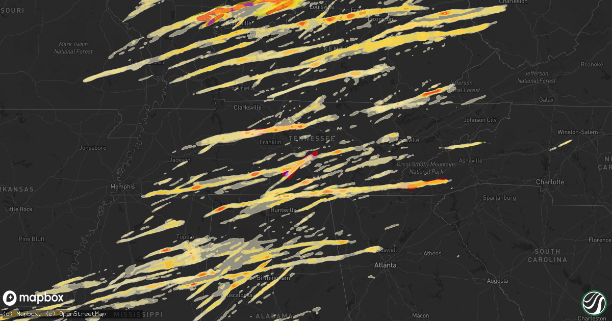
Hail Map in Tennessee on March 2, 2012
Get this storm
March 2 map
$229
one time, instant access
Download today. No call, no setup
Keep the $229
Bought the map and want the full workflow? Apply the entire $229 to a subscription within 7 days. None of it is wasted.
Every map, not just this one
This buys you this map. Subscription and you get every map we run, in the markets you choose from a few cities to whole states to nationwide. Plus real-time alerts the moment a storm fires.
Contact data
Name, contact info, occupancy, even credit band for addresses in the footprint. You go from where it hit to who to call.
Become the source they trust
Unlimited branding weather history reports on demand. You already have the documented answer ready for the property owner, and you are the one who showed up with it.
Property data and RoofTrace estimates
Pull up any address you have got, its value and the exact code rules for that jurisdiction, straight from One Click Code. Then RoofTrace estimates the squares, pitch, and roof value, priced the way you price.
Storm reports in Tennessee
Tennessee
| Date | Description |
|---|---|
| 03/02/20125:53 PM CST | Lawrence county ema reported golfball size hail at ethridge. |
| 03/02/20125:45 PM CST | From volunteer electric reported multiple power lines down from trees and lightning. |
| 03/02/20125:43 PM CST | A local report indicates 1.25 inch wind near 3 W OOLTEWAH |
| 03/02/20125:36 PM CST | Tennis ball size hail on highway 27 in chattanooga. |
| 03/02/20125:32 PM CST | Over 100 trees down and people trapped near east white hall road 6 m n of cookeville. |
| 03/02/20125:32 PM CST | Tornado reported near hwy 136 near the putnam county-overton county line. |
| 03/02/20125:31 PM CST | A local report indicates 1.75 inch wind near CHATTANOOGA |
| 03/02/20125:30 PM CST | House and barn destroyed at 135 cummins mills road in putnam county. Possible tornado. |
| 03/02/20125:30 PM CST | A local report indicates 1.00 inch wind near RED BANK |
| 03/02/20125:30 PM CST | Putnam county emergency management reported the following damage...two houses destroyed in northern putnam county near the jackson county line. Possible tornado at zion |
| 03/02/20125:30 PM CST | Public reported a tornado outside of chattanooga on interstate i-24. |
| 03/02/20125:26 PM CST | *** 3 inj *** ef2 tornado with maximum estimated wind speeds of about 125 mph touched down in the dodson branch community of southeastern jackson county. The tornado sp |
| 03/02/20125:25 PM CST | *** 3 inj *** extensive damage and 3 injuries in dodsons branch. Reported by 911 center. Possible tornado. |
| 03/02/20125:25 PM CST | Possible tornado in the dodsons branch community.....27 houses with major damage plus an additional 38 houses with minor to major damage. Damage area is 1 mile deep by |
| 03/02/20125:20 PM CST | Trees down on power lines. |
| 03/02/20125:11 PM CST | A tree fell on a house on rally hill road...also a light pole was downed on highway 31 near columbia. |
| 03/02/20125:11 PM CST | A local report indicates 1.75 inch wind near LYNNVILLE |
| 03/02/20125:10 PM CST | Trees down near dayton |
| 03/02/20125:08 PM CST | Golf ball size hail in downtown jellico. |
| 03/02/20125:06 PM CST | Spotter reported golfball-size hail at the grandview medical center. |
| 03/02/20125:00 PM CST | Quarter size hail in souths pittsburg. |
| 03/02/20125:00 PM CST | A local report indicates 2.75 inch wind near 3 SW JASPER |
| 03/02/20124:55 PM CST | Spotter reported half dollar size hail at carthage. |
| 03/02/20124:55 PM CST | Golfball size hail reported. |
| 03/02/20124:53 PM CST | Baseball size hail broke windows on house in tuckers crossroads area |
| 03/02/20124:45 PM CST | Couple of trees down northern part of hamiton county |
| 03/02/20124:45 PM CST | Trees down countywide bledsoe county |
| 03/02/20124:45 PM CST | Multiple trees down around 845pm near highway 27 |
| 03/02/20124:45 PM CST | A double-wide trailor was pulled off its foundation and flipped. |
| 03/02/20124:37 PM CST | Quarter size hail reported by spotter just north of lebanon. |
| 03/02/20124:34 PM CST | 2 inch hail reported by spotter. |
| 03/02/20124:34 PM CST | Hen egg size hail reported by a spotter on the western side of lebanon. |
| 03/02/20124:30 PM CST | Volunteer electric reports multiple power lines down across roane county from trees and lightning |
| 03/02/20124:30 PM CST | Hen egg size hail reported just east of lebanon at 8000 trousdale ferry pike. Homes and vehicles damaged. |
| 03/02/20124:18 PM CST | A local report indicates 1.75 inch wind near 4 SW MOUNT JULIET |
| 03/02/20124:16 PM CST | Trained spotter reports quarter sized hail in antioch. |
| 03/02/20124:10 PM CST | A local report indicates 1.50 inch wind near SW BERRY HILL |
| 03/02/20124:10 PM CST | Golfball hail at 23rd avenue and patterson in nashville. |
| 03/02/20124:10 PM CST | Numerous reports of golfball size hail around the nashville airport. |
| 03/02/20124:10 PM CST | A local report indicates 2.00 inch wind near 1 WNW BERRY HILL |
| 03/02/20124:08 PM CST | A local report indicates 1.00 inch wind near NASHVILLE |
| 03/02/20124:08 PM CST | Quarter size hail covering ground in community of olive hill. |
| 03/02/20124:07 PM CST | A local report indicates 1.75 inch wind near NASHVILLE |
| 03/02/20124:06 PM CST | Half dollar sized hail reported 1 m w of nashville. |
| 03/02/20124:06 PM CST | Golf ball sized hail reported at lipscomb university. |
| 03/02/20124:04 PM CST | A local report indicates 1.00 inch wind near 1 WNW BELLE MEADE |
| 03/02/20124:03 PM CST | Trained spotter reported quarter sized hail 1 m e of nashville. |
| 03/02/20124:03 PM CST | Hail up to golfball size reported at the nashville emeregency operations center. At least two dozen vehicles damaged. |
| 03/02/20124:00 PM CST | A few small trees down and tree limbs down along with some shingle damage in the cravens area of savannah. |
| 03/02/20124:00 PM CST | Report of ping pong sized hail in bellevue. |
| 03/02/20124:00 PM CST | Hail fell in the community of olivet. |
| 03/02/20124:00 PM CST | Hail broke house windows |
| 03/02/20123:57 PM CST | Tornado damage reported in boonshill. Shingles blown off of the community center and several trees were uprooted. |
| 03/02/20123:56 PM CST | Golfball sized hail reported on interstate 40 and exit 196 in bellevue. |
| 03/02/20123:50 PM CST | Trees down over southern dickson county. |
| 03/02/20123:48 PM CST | Ef-1 tornado with maximum wind speeds around 90 mph touched down along mt pleasant road just south of kingston springs. The nearly 1 mile damage path of the tornado con |
| 03/02/20123:45 PM CST | Accompanied by golfball hail ...noted in previous report |
| 03/02/20123:45 PM CST | Golfball hail with 60 mph winds producing severe tree damage and broken windows |
| 03/02/20123:44 PM CST | A local report indicates 3.00 inch wind near STANTONVILLE |
| 03/02/20123:40 PM CST | Trees down and power out in southern cheatham county. Reported by cheatham county emergency management. |
| 03/02/20123:30 PM CST | Some nickel to quarter sized hail but mainly half dollar sized hail. |
| 03/02/20123:30 PM CST | Dickson co ema - reports roof blown off the hampton inn at hwy 46 interstate 40. Possible tornado. |
| 03/02/20123:30 PM CST | Volunteer electric reports multiple power lines down from rees and lightning across miegs and rhea county |
| 03/02/20123:25 PM CST | Possible tornado has produced the following damage in dickson...damage to a waffle house at highway 46 and interstate 40 and homes damaged in southern parts of the city |
| 03/02/20123:25 PM CST | Quarter size hail near lenoir city. |
| 03/02/20123:25 PM CST | Emergency management reports golfball size hail at dickson. |
| 03/02/20123:25 PM CST | Baseball size hail was reported. |
| 03/02/20123:13 PM CST | Roof blown off a barn and several trees down. |
| 03/02/20123:12 PM CST | A local report indicates 1.75 inch wind near MIDDLETON |
| 03/02/20123:10 PM CST | Quarter size hail was reported. |
| 03/02/20123:03 PM CST | Deep enough to cause fog in the valleys |
| 03/02/20123:00 PM CST | Quarter size hail was reported. |
| 03/02/20123:00 PM CST | Estimated 75 mph winds produced tree and power line damage. Some minor structural damage. In addition...pea hail covered the ground. Roof torn off a building on west ma |
| 03/02/20122:55 PM CST | A local report indicates 1.75 inch wind near GRAND JUNCTION |
| 03/02/20122:53 PM CST | A local report indicates 1.00 inch wind near GRAND JUNCTION |
| 03/02/20122:52 PM CST | A local report indicates 1.75 inch wind near 6 ENE WARTRACE |
| 03/02/20122:45 PM CST | A few stray trees down countywide...mainly of dunlap |
| 03/02/20122:45 PM CST | Golfball hail reported at beechgrove by amateur radio. |
| 03/02/20122:45 PM CST | An ef-0 tornado with maximum winds at 65 mph had a .6 mile path and a 50 yard path width. The tornado produced minor shingle damage to the boonshill community center... |
| 03/02/20122:45 PM CST | Golf ball size hail reported at park city. |
| 03/02/20122:45 PM CST | Spotter reported one inch hail at wartrace. |
| 03/02/20122:42 PM CST | Trees down across southern carroll county. Specifically near goodrum...black gully...and purdy roads. |
| 03/02/20122:41 PM CST | Emergency management reported large hail 5 miles southeast of shelbyville. |
| 03/02/20122:40 PM CST | Tornado damage reported in boonshill. Shingles blown off of the community center and several trees were uprooted. |
| 03/02/20122:40 PM CST | Several trees down |
| 03/02/20122:35 PM CST | Golf ball size hail reported. |
| 03/02/20122:20 PM CST | An ef-0 tornado with maximum winds at 65 mph had just over 1/2 mile path length and a 50 yard path width. The short-lived tornado produced minor shingle damage to the b |
| 03/02/20122:03 PM CST | Deep enough to cause fog in the valleys |
| 03/02/201212:54 PM CST | Survey found an ef-2 with max winds of 130 mph. Path width of 300 yards. Path length of 7 miles. |
| 03/02/201212:45 PM CST | Possible tornado. Tornado spotted in tellico plains. Numerous trees and power lines down. |
| 03/02/201212:40 PM CST | Multiple power lines down from fallen trees and lightning county-wide. |
| 03/02/201212:40 PM CST | Severe damage to a home including windows broken and collapsed garage. Several large trees and power lines reported down. |
| 03/02/201212:40 PM CST | Several trees down county-wide. |
| 03/02/201212:33 PM CST | A local report indicates 1.00 inch wind near ETOWAH |
| 03/02/201212:30 PM CST | Preliminary survey found an ef-2 with max winds of 130 mph. |
| 03/02/201212:30 PM CST | Possible tornado. Tornado spotted near delano. |
| 03/02/201212:30 PM CST | Couple of trees down northern hamilton county |
| 03/02/201212:05 PM CST | *** 6 inj *** emergency manager reports 100 homes damaged and several businesses damaged |
| 03/02/201212:00 PM CST | Several trees down. Trampoline in a tree. Power lines down |
| 03/02/201212:00 PM CST | 2 trees down in georgetown |
| 03/02/201211:55 AM CST | Homes damaged and numerous trees down in the prospect community. |
| 03/02/201211:50 AM CST | Possible tornado. Tornado spotted just west of interstate 75 on hunter rd. |
| 03/02/201211:45 AM CST | *** 30 inj *** preliminary survey found ef3 tornado with max winds of 165 mph. Storm tracked 9.3 miles in hamilton and 16.6 miles in bradley county. The storm entered b |
| 03/02/201211:45 AM CST | Several trees down countywide |
| 03/02/201211:40 AM CST | Trees and power lines down. |
| 03/02/201211:40 AM CST | Numerous trees down. Dock and boats damaged. Numerous homes with damage. |
| 03/02/201211:10 AM CST | Volunteer electric repotrs multiple pwers line down from trees and lightning countywide |
| 03/02/201211:10 AM CST | A local report indicates 1.00 inch wind near JASPER |
| 03/02/201211:04 AM CST | Rv blown over. |
| 03/01/201210:45 PM CST | Couple trees down countywide |
| 03/01/201210:00 PM CST | Seevral trees down. |
| 03/01/20129:45 PM CST | Several trees down. |
| 03/01/20129:45 PM CST | Several trees down. |
| 03/01/20129:15 PM CST | Numerous trees down in the eastern half of the county. |
| 03/01/20129:05 PM CST | Ef0 tornado with max winds of 80 mph. Path length of 2.1 miles and a width of 100 yards. Sporadic tree damage and one trailer rolled. |
| 03/01/20128:45 PM CST | Several trees down. |
| 03/01/20128:40 PM CST | A local report indicates 1.00 inch wind near CLINTON |
| 03/01/20128:35 PM CST | Ping pong ball sized hail near claxton. |
| 03/01/20128:24 PM CST | A local report indicates 1.00 inch wind near OLIVER SPRINGS |
| 03/01/20128:15 PM CST | Several trees down countywide |
| 03/01/20127:38 PM CST | Quarter sized hail report by amatuer radio. Located near the town of lantana. |
| 03/01/20127:29 PM CST | Possible tornado...dispatch reported trees down and a few houses damaged. |
| 03/01/20127:23 PM CST | Ef2 tornado with 120 mph max winds. Path width of 250 yard. Several roofs blown off of homes. |
| 03/01/20127:03 PM CST | Confirmed by photos. Location and time approximate. |
| 03/01/20127:00 PM CST | A local report indicates 1.25 inch wind near WATERVILLE |
| 03/01/20127:00 PM CST | A local report indicates 1.75 inch wind near JELLICO |
| 03/01/20126:50 PM CST | A local report indicates 1.00 inch wind near MCDONALD |
| 03/01/20126:30 PM CST | A local report indicates 1.75 inch wind near ONEIDA |
| 03/01/20126:29 PM CST | Amateur radio operator reports quarter size hail between lewisburg and interstate 65. |
| 03/01/20126:25 PM CST | *** 3 inj *** extensive damage and 3 injuries in dodsons branch. Reported by 911 center. Possible tornado. |
| 03/01/20126:25 PM CST | Quarter size hail reported 6ene wartrace. |
| 03/01/20126:25 PM CST | Several trees down. |
| 03/01/20126:07 PM CST | Quarter size hail reported by amateur radio operator. |
| 03/01/20126:03 PM CST | Amateur radio operator reported golf ball sized hail in shelbyville. |
| 03/01/20126:00 PM CST | Silver dollar size hail reported at ethridge. |
| 03/01/20126:00 PM CST | Barn destroyed. Neighbors house roof ripped off. Near the intersection of hardys chapel road and crawfords chapel road. |
| 03/01/20126:00 PM CST | Quarter size hail in maryville |
| 03/01/20126:00 PM CST | Emergency manager reports baseball size hail in campbellsville tn. |
| 03/01/20126:00 PM CST | Coop observer reports house destroyed near hardys chapel road near the putnam and overton county line. People trapped in house. |
All States Impacted by Hail Map on March 2, 2012
Cities Impacted by Hail Map on March 2, 2012
- Starkville, MS
- Oakdale, IL
- Coulterville, IL
- Salyersville, KY
- West Liberty, KY
- Cannel City, KY
- Saint Charles, MO
- Bowling Green, KY
- Rockfield, KY
- Amory, MS
- Aberdeen, MS
- Okolona, MS
- Fyffe, AL
- Geraldine, AL
- Sewanee, TN
- Winchester, TN
- Johnsonville, IL
- Iuka, IL
- Ladoga, IN
- Roachdale, IN
- Morris, AL
- Pinson, AL
- Ashville, AL
- Jacksonville, AL
- Ohatchee, AL
- Wellington, AL
- Holcomb, MS
- Unionville, TN
- Readyville, TN
- Lewisburg, TN
- Rockvale, TN
- Murfreesboro, TN
- Bradyville, TN
- Beechgrove, TN
- Bell Buckle, TN
- Christiana, TN
- Woodbury, TN
- Mcminnville, TN
- Chapel Hill, TN
- Anguilla, MS
- Richmond, IN
- Keyesport, IL
- Smithboro, IL
- Greenville, IL
- Mason, IL
- Watson, IL
- Effingham, IL
- Altamont, IL
- Brownstown, IL
- Saint Elmo, IL
- Pelahatchie, MS
- Brandon, MS
- Morton, MS
- Ethridge, TN
- Saint Anthony, IN
- Huntingburg, IN
- Birdseye, IN
- Dubois, IN
- Jasper, IN
- Celestine, IN
- Mount Vernon, IN
- Sandy Hook, KY
- Isonville, KY
- Gallipolis, OH
- Thurman, OH
- Patriot, OH
- Gallipolis Ferry, WV
- Henderson, WV
- Bidwell, OH
- Oak Hill, OH
- Point Pleasant, WV
- Cedarbluff, MS
- Pheba, MS
- Gate City, VA
- Weber City, VA
- Hiltons, VA
- Staunton, IL
- Gillespie, IL
- Wilsonville, IL
- Benld, IL
- Bunker Hill, IL
- Sawyerville, IL
- Mount Olive, IL
- Newcomb, TN
- Jellico, TN
- Williamsburg, KY
- Tupelo, MS
- Mooreville, MS
- Thomasville, AL
- Pine Hill, AL
- Camden, AL
- Coy, AL
- Coffeeville, AL
- Grove Hill, AL
- Lower Peach Tree, AL
- Scottsville, KY
- Pitkin, LA
- Richmond, KY
- Stanton, KY
- Winchester, KY
- Frenchburg, KY
- Means, KY
- Jeffersonville, KY
- Clay City, KY
- Pontotoc, MS
- Murphysboro, IL
- Waverly, TN
- Carthage, TN
- White Bluff, TN
- Elmwood, TN
- Kingston Springs, TN
- Holladay, TN
- Hermitage, TN
- Nashville, TN
- New Johnsonville, TN
- Burns, TN
- Mount Juliet, TN
- Lebanon, TN
- Pegram, TN
- Dickson, TN
- McEwen, TN
- Camden, TN
- Watertown, TN
- Fairview, TN
- Gordonsville, TN
- Hurricane Mills, TN
- Baskin, LA
- Delhi, LA
- Millstadt, IL
- Columbia, IL
- Belleville, IL
- Dupo, IL
- East Carondelet, IL
- Lawrenceburg, TN
- Savannah, TN
- Loretto, TN
- Westpoint, TN
- Leoma, TN
- Pulaski, TN
- Collinwood, TN
- Lutts, TN
- Iron City, TN
- Waterloo, AL
- Cypress Inn, TN
- Bessemer, AL
- New Ross, IN
- Advance, IN
- Russellville, IN
- Jamestown, IN
- Cohutta, GA
- Crandall, GA
- Dalton, GA
- New Market, AL
- Ardmore, TN
- Taft, TN
- Fayetteville, TN
- Ardmore, AL
- Kelso, TN
- Hazel Green, AL
- Athens, AL
- Elkmont, AL
- Toney, AL
- Enid, MS
- Pope, MS
- Etta, MS
- Guntown, MS
- Batesville, MS
- New Albany, MS
- Oxford, MS
- Blue Springs, MS
- Thaxton, MS
- Water Valley, MS
- Courtland, MS
- Baldwyn, MS
- Taylor, MS
- Myrtle, MS
- Georgetown, OH
- Poseyville, IN
- Manchester, TN
- Beech Bluff, TN
- Jackson, TN
- Medon, TN
- Grantsburg, IN
- English, IN
- Hartselle, AL
- Danville, AL
- Oliver Springs, TN
- Cub Run, KY
- Mammoth Cave, KY
- Flintstone, GA
- Rossville, GA
- Gattman, MS
- Detroit, AL
- Sulligent, AL
- Greenwood Springs, MS
- Fayette, AL
- Vernon, AL
- Kennedy, AL
- Elizabethtown, IN
- Westport, IN
- Greensburg, IN
- Hartsville, IN
- Columbus, IN
- Bedford, KY
- Hanover, IN
- Nabb, IN
- Scottsburg, IN
- Milton, KY
- Lexington, IN
- Houston, OH
- Piqua, OH
- Covington, OH
- Clay City, IL
- Dix, IL
- Kell, IL
- Texico, IL
- Centre, AL
- Lewisburg, KY
- Dunmor, KY
- Belton, KY
- Greenville, KY
- Elkton, KY
- Estill Springs, TN
- Lascassas, TN
- Mooreland, IN
- New Castle, IN
- Losantville, IN
- Killen, AL
- Florence, AL
- Cherokee, AL
- Warren, IN
- Grant, AL
- Hillsboro, IL
- Livingston, IL
- Moro, IL
- South Roxana, IL
- Beecher City, IL
- Roxana, IL
- East Alton, IL
- Wood River, IL
- Saint Louis, MO
- West Alton, MO
- Hamel, IL
- Fillmore, IL
- Florissant, MO
- Cowden, IL
- Edwardsville, IL
- Granite City, IL
- Cottage Hills, IL
- Worden, IL
- Ramsey, IL
- Coffeen, IL
- Bingham, IL
- Sorento, IL
- Bethalto, IL
- Hartford, IL
- Alton, IL
- Herrick, IL
- Godfrey, IL
- Alhambra, IL
- Dorsey, IL
- New Douglas, IL
- Donnellson, IL
- Toxey, AL
- Campbell, AL
- Dixons Mills, AL
- Silas, AL
- Arlington, AL
- Gilbertown, AL
- Glasgow, KY
- Cromwell, KY
- Horse Branch, KY
- Beaver Dam, KY
- Leitchfield, KY
- Caneyville, KY
- Millwood, KY
- Sweet Water, AL
- Bastrop, LA
- Tuckasegee, NC
- Franklin, NC
- Sylva, NC
- Glenville, NC
- Cullowhee, NC
- Dixon, KY
- Clay, KY
- Winnsboro, LA
- Mangham, LA
- Waverly, KY
- Crawford, MS
- Columbus, MS
- Joelton, TN
- Ashland City, TN
- Farmerville, LA
- Simsboro, LA
- Ruston, LA
- Sterlington, LA
- Choudrant, LA
- Gibsland, LA
- Arcadia, LA
- Marion, LA
- Dubach, LA
- Downsville, LA
- Louisa, KY
- Morehead, KY
- Wayne, WV
- Fort Gay, WV
- Grayson, KY
- Webbville, KY
- Clearfield, KY
- Catlettsburg, KY
- Olive Hill, KY
- Prichard, WV
- Salt Lick, KY
- Coalmont, TN
- Beersheba Springs, TN
- Palmer, TN
- Dunlap, TN
- Gruetli Laager, TN
- Pikeville, TN
- Altamont, TN
- Rogersville, AL
- Muscle Shoals, AL
- Gipsy, MO
- Greenville, MO
- Lowndes, MO
- Marble Hill, MO
- Zalma, MO
- Evansville, IN
- Kennesaw, GA
- Acworth, GA
- London, KY
- East Bernstadt, KY
- Hamlin, WV
- Myra, WV
- Branchland, WV
- Hulen, KY
- Evarts, KY
- Pineville, KY
- Wallins Creek, KY
- Ages Brookside, KY
- Kenvir, KY
- Miracle, KY
- Coalgood, KY
- Cawood, KY
- Grays Knob, KY
- Mary Alice, KY
- Pathfork, KY
- Middlesboro, KY
- Harlan, KY
- Gulston, KY
- Duck Hill, MS
- Hamilton, AL
- Woodland, MS
- Mantee, MS
- Beaverton, AL
- Hamilton, MS
- Gore Springs, MS
- Nettleton, MS
- Vardaman, MS
- Eupora, MS
- Maben, MS
- Prairie, MS
- Smithville, MS
- Calhoun City, MS
- Stewart, MS
- West Point, MS
- Bellefontaine, MS
- Houston, MS
- Lebanon Junction, KY
- Shepherdsville, KY
- Westfield, IL
- Toledo, IL
- Kansas, IL
- Charleston, IL
- Casey, IL
- Ashmore, IL
- Lerna, IL
- Trilla, IL
- Quitman, LA
- Bienville, LA
- Trussville, AL
- Springville, AL
- Shannon, MS
- New Liberty, KY
- Jonesville, KY
- Dry Ridge, KY
- Sanders, KY
- Sparta, KY
- Glencoe, KY
- Williamsport, KY
- Thelma, KY
- Beattyville, KY
- West Van Lear, KY
- Rogers, KY
- Oil Springs, KY
- Mize, KY
- Tomahawk, KY
- Meally, KY
- Hazel Green, KY
- Paintsville, KY
- Tutor Key, KY
- Staffordsville, KY
- Boons Camp, KY
- Campton, KY
- Slade, KY
- Hagerhill, KY
- Pine Ridge, KY
- Philadelphia, TN
- Niota, TN
- Soddy Daisy, TN
- Decatur, TN
- Sale Creek, TN
- Ten Mile, TN
- Athens, TN
- Sweetwater, TN
- Greenback, TN
- Evensville, TN
- Vonore, TN
- Loudon, TN
- Graysville, TN
- Dayton, TN
- Madisonville, TN
- Berry, AL
- Oakman, AL
- Parrish, AL
- Mount Sterling, KY
- Paris, KY
- Winfield, TN
- Oneida, TN
- Marshall, IN
- Rockville, IN
- Chattanooga, TN
- Pleasant Hill, LA
- Coushatta, LA
- Jonesboro, LA
- Winnfield, LA
- Goldonna, LA
- Robeline, LA
- Pelican, LA
- Dodson, LA
- Campti, LA
- Saline, LA
- Michie, TN
- Shiloh, TN
- Ramer, TN
- Selmer, TN
- Guys, TN
- Stantonville, TN
- Scottsboro, AL
- Birmingham, AL
- Dallas, GA
- Edmonton, KY
- Lynnville, TN
- Summertown, TN
- Jasper, TX
- Wiergate, TX
- Newton, TX
- Burkeville, TX
- Rockport, IN
- Olla, LA
- Mississippi State, MS
- Sharpsburg, KY
- Carlisle, KY
- Gardendale, AL
- Murphy, NC
- Prospect, TN
- Gurley, AL
- Middleton, TN
- Hillsboro, TN
- Ocoee, TN
- Meridianville, AL
- Ringgold, GA
- Holly Springs, MS
- Andrews, NC
- Topton, NC
- Harriman, TN
- McDonald, TN
- Decherd, TN
- Harvest, AL
- Sherwood, TN
- Frankewing, TN
- Normandy, TN
- Tuscumbia, AL
- Sardis, TN
- Leighton, AL
- Hollywood, AL
- Cleveland, TN
- Rockwood, TN
- Shelbyville, TN
- Fort Oglethorpe, GA
- Fackler, AL
- Culleoka, TN
- Morris Chapel, TN
- Saltillo, TN
- Saulsbury, TN
- Adamsville, TN
- Iuka, MS
- Tishomingo, MS
- Counce, TN
- Moscow, TN
- Bryant, AL
- Whitwell, TN
- Sequatchie, TN
- Belfast, TN
- Wildwood, GA
- Marble, NC
- Crump, TN
- Hixson, TN
- Grand Junction, TN
- Harrison, TN
- Farner, TN
- Petersburg, TN
- Benton, TN
- Dennis, MS
- Madison, AL
- Huntland, TN
- Reliance, TN
- Waynesboro, TN
- Stevenson, AL
- Rossville, TN
- Elora, TN
- Byhalia, MS
- Spring City, TN
- Cowan, TN
- Bethel Springs, TN
- Red Banks, MS
- Flat Rock, AL
- Turtletown, TN
- Copperhill, TN
- Courtland, AL
- Old Fort, TN
- Morrison, TN
- Ooltewah, TN
- Whiteside, TN
- Lookout Mountain, GA
- Jasper, TN
- Belvidere, TN
- South Pittsburg, TN
- Cornersville, TN
- Flintville, TN
- Hornsby, TN
- Woodville, AL
- Estillfork, AL
- Trenton, GA
- Town Creek, AL
- Grandview, TN
- Huntsville, AL
- Wartrace, TN
- Pocahontas, TN
- Signal Mountain, TN
- Lamar, MS
- Dellrose, TN
- Pelham, TN
- La Grange, TN
- Spencer, TN
- Sheffield, AL
- Monteagle, TN
- Bridgeport, AL
- Olivehill, TN
- Rock Island, TN
- Lester, AL
- Mulberry, TN
- Hayesville, NC
- Hillsboro, AL
- Guild, TN
- Crossville, TN
- Tracy City, TN
- Apison, TN
- Lookout Mountain, TN
- Paint Rock, AL
- Tanner, AL
- Russellville, AL
- Foster, KY
- Greenville, MS
- Lake Village, AR
- Mount Eden, KY
- Walnut Hill, IL
- Odin, IL
- Nashville, IL
- Centralia, IL
- Salem, IL
- Addieville, IL
- Hoyleton, IL
- Shelbyville, KY
- Owensboro, KY
- Morganfield, KY
- Calhoun, KY
- Sebree, KY
- Nebo, KY
- Pittsboro, MS
- Houlka, MS
- Durant, MS
- Vaiden, MS
- Mathiston, MS
- Hollandale, MS
- Millport, AL
- Silver City, MS
- Louise, MS
- Tchula, MS
- Ackerman, MS
- Kilmichael, MS
- Lexington, MS
- West, MS
- Coila, MS
- Ethel, MS
- Steens, MS
- Weir, MS
- French Camp, MS
- Cruger, MS
- Belzoni, MS
- Sturgis, MS
- Fulton, MO
- Science Hill, KY
- Somerset, KY
- Guntersville, AL
- Stonington, IL
- Taylorville, IL
- Palmer, IL
- Morrisonville, IL
- North Salem, IN
- Salem, IN
- Pekin, IN
- Sharon Grove, KY
- Indianola, MS
- Crossett, AR
- Portland, AR
- Doddsville, MS
- Moorhead, MS
- Hamburg, AR
- Dermott, AR
- Leland, MS
- Montrose, AR
- Inverness, MS
- Shaw, MS
- Itta Bena, MS
- Uniontown, KY
- Henderson, KY
- Corydon, KY
- Oak Grove, LA
- Sturgis, KY
- Utica, KY
- Farina, IL
- Shoals, IN
- Columbia, LA
- Olney, IL
- Noble, IL
- Carmi, IL
- Indianapolis, IN
- Avon, IN
- Carmel, IN
- Center, TX
- Leesville, LA
- Anacoco, LA
- Evans, LA
- Campbellsburg, IN
- Pana, IL
- Tower Hill, IL
- Vanceburg, KY
- Stout, OH
- Jena, LA
- Jonesville, LA
- Grayson, LA
- Rayville, LA
- Monroe, LA
- Chatham, LA
- Vicksburg, MS
- Redwood, MS
- Bolton, MS
- Tallulah, LA
- Bentonia, MS
- Sikes, LA
- Columbia, KY
- Alexander City, AL
- Jamestown, TN
- Borden, IN
- Yazoo City, MS
- Rolling Fork, MS
- Morgantown, KY
- La Fontaine, IN
- Converse, IN
- Amboy, IN
- Celina, TN
- Tompkinsville, KY
- Burkesville, KY
- Paris, IL
- Owingsville, KY
- Greenwood, IN
- Holton, IN
- North Vernon, IN
- Butlerville, IN
- Scipio, IN
- Gays, IL
- Windsor, IL
- Woodstock, AL
- West Blocton, AL
- Bethel, OH
- New Richmond, OH
- Moscow, OH
- California, KY
- Alexandria, KY
- Gravel Switch, KY
- Parksville, KY
- Bradfordsville, KY
- Lebanon, KY
- Homer, LA
- Bernice, LA
- Marion, IN
- Waterford, MS
- Potts Camp, MS
- Nancy, KY
- Hartsville, TN
- Castalian Springs, TN
- Bethpage, TN
- Whitleyville, TN
- Moss, TN
- Gallatin, TN
- Gamaliel, KY
- Dixon Springs, TN
- Lafayette, TN
- Red Boiling Springs, TN
- Greenup, IL
- Mattoon, IL
- Martinsville, IL
- Neoga, IL
- Winchester, OH
- Michigan City, MS
- Ashland, MS
- Mount Washington, KY
- Bardstown, KY
- Deatsville, AL
- Titus, AL
- Marbury, AL
- Holly Pond, AL
- New Hope, KY
- Loretto, KY
- New Haven, KY
- Ekron, KY
- Brandenburg, KY
- Guston, KY
- Irvington, KY
- South Shore, KY
- Pedro, OH
- Greenup, KY
- Franklin Furnace, OH
- Wheelersburg, OH
- South Webster, OH
- New Harmony, IN
- Crossville, IL
- Genoa, WV
- Wellington, KY
- East Lynn, WV
- Waco, KY
- Ezel, KY
- Dunlow, WV
- Elkfork, KY
- Adams, KY
- Martha, KY
- Blaine, KY
- Breese, IL
- Trenton, IL
- Aviston, IL
- Carlyle, IL
- Tunnel Hill, GA
- Hillsdale, IN
- Dana, IN
- Chrisman, IL
- Taylorsville, KY
- Knightsville, IN
- Staunton, IN
- Brazil, IN
- Buchanan, GA
- Cedartown, GA
- Whiteville, TN
- Bolivar, TN
- Somerville, TN
- Dawson, AL
- Warsaw, KY
- Florence, IN
- Patriot, IN
- Rising Sun, IN
- Vevay, IN
- Ghent, KY
- Owenton, KY
- Carrollton, KY
- Turners Station, KY
- Worthville, KY
- Campbellsburg, KY
- West Newton, IN
- Camby, IN
- Burnside, KY
- Bronston, KY
- Martinsville, IN
- Bentley, LA
- Pollock, LA
- Booneville, KY
- Lebanon, IN
- Rineyville, KY
- Ellsinore, MO
- Bainbridge, IN
- Greencastle, IN
- Yawkey, WV
- Sod, WV
- Sumerco, WV
- Norris City, IL
- Enfield, IL
- Hagerstown, IN
- Madison, IN
- Joaquin, TX
- Nacogdoches, TX
- Zwolle, LA
- Chireno, TX
- San Augustine, TX
- Marthaville, LA
- Noble, LA
- Atlanta, LA
- Natchitoches, LA
- Converse, LA
- Belmont, LA
- Shelbyville, TX
- Campbellsville, KY
- Raywick, KY
- Magnolia, KY
- Buffalo, KY
- Mount Sherman, KY
- Wildersville, TN
- Coldiron, KY
- Dayhoit, KY
- Baxter, KY
- Bledsoe, KY
- Putney, KY
- Clayton, IN
- Knoxville, TN
- Irvine, KY
- Crab Orchard, KY
- Danville, KY
- Lancaster, KY
- Berea, KY
- Paint Lick, KY
- Stanford, KY
- Carthage, IN
- Knightstown, IN
- Patoka, IN
- Deputy, IN
- Highland, IL
- Advance, NC
- Mocksville, NC
- Columbia, TN
- Terre Haute, IN
- Owens Cross Roads, AL
- Abbeville, MS
- Decatur, IL
- Friedheim, MO
- Fredericktown, MO
- Sedgewickville, MO
- Perryville, MO
- Marquand, MO
- Farrar, MO
- Patton, MO
- Frohna, MO
- Hardyville, KY
- Munfordville, KY
- Roundhill, KY
- Bonnieville, KY
- Horse Cave, KY
- Canmer, KY
- Brownsville, KY
- Aliceville, AL
- Carrollton, AL
- Macon, MS
- Maryville, TN
- Montgomery City, MO
- Junction, IL
- Kermit, WV
- Breeden, WV
- Winfield, AL
- Guin, AL
- Hardinsburg, KY
- Webster, KY
- Cannelton, IN
- Rome, IN
- Lewisport, KY
- Payneville, KY
- Stephensport, KY
- Hawesville, KY
- Union Star, KY
- Philpot, KY
- Maceo, KY
- Laconia, IN
- Helenwood, TN
- Duff, TN
- Frakes, KY
- Clairfield, TN
- Holmes Mill, KY
- Closplint, KY
- Hodgenville, KY
- Cookeville, TN
- Jonesboro, IN
- Swayzee, IN
- Cambridge City, IN
- Straughn, IN
- Greens Fork, IN
- Meridian, MS
- De Kalb, MS
- Daleville, MS
- Collinsville, MS
- Bailey, MS
- Cuba, AL
- Toomsuba, MS
- Mitchell, IN
- West Baden Springs, IN
- French Lick, IN
- Orleans, IN
- Strunk, KY
- Deridder, LA
- Merryville, LA
- Rosepine, LA
- Kirbyville, TX
- Centertown, KY
- Carrollton, MS
- Winona, MS
- Greenwood, MS
- Woodworth, LA
- Alexandria, LA
- Gainesboro, TN
- Granville, TN
- Chandler, IN
- Stilesville, IN
- Mooresville, IN
- Monrovia, IN
- Universal, IN
- Hidalgo, IL
- Fillmore, IN
- Rosedale, IN
- Harmony, IN
- Wheeler, IL
- Yale, IL
- Mecca, IN
- Centerpoint, IN
- Carbon, IN
- Amo, IN
- Cloverdale, IN
- Oblong, IL
- Willow Hill, IL
- Plainfield, IN
- Waveland, IN
- Riley, IN
- Reelsville, IN
- Greenfield, IN
- New Goshen, IN
- West York, IL
- Cory, IN
- Newton, IL
- Putnamville, IN
- Poland, IN
- West Union, IL
- Beech Grove, IN
- Marshall, IL
- Montezuma, IN
- Coatesville, IN
- Clinton, IN
- Annapolis, IL
- Crawfordsville, IN
- Dennison, IL
- West Terre Haute, IN
- Danville, IN
- Sondheimer, LA
- Epps, LA
- Pioneer, LA
- Lake Providence, LA
- Pleasureville, KY
- Lockport, KY
- Bethlehem, KY
- West Liberty, IL
- Dundas, IL
- Ethelsville, AL
- Marysville, IN
- Monterey, TN
- Clarkrange, TN
- Pennington Gap, VA
- Pioneer, TN
- La Follette, TN
- Cranks, KY
- Speedwell, TN
- Saint Charles, VA
- Goodman, MS
- Kosciusko, MS
- Pickens, MS
- McCool, MS
- Sallis, MS
- Benton, MS
- Moody, AL
- Odenville, AL
- Lexington, TN
- Westport, TN
- Old Hickory, TN
- Madison, TN
- Milam, TX
- Eckerty, IN
- Bristow, IN
- Nicholasville, KY
- Calhoun, LA
- West Monroe, LA
- Ridgeland, MS
- Jackson, MS
- Madison, MS
- White Hall, IL
- Clarksville, MO
- Annada, MO
- Hamburg, IL
- Kampsville, IL
- Elsberry, MO
- Eldred, IL
- Roodhouse, IL
- Silex, MO
- Hillview, IL
- Eolia, MO
- Nebo, IL
- Bellflower, MO
- Murrayville, IL
- Salem, KY
- Burnsville, NC
- Hot Springs, NC
- Hartford, TN
- Mars Hill, NC
- Del Rio, TN
- Marshall, NC
- Cosby, TN
- Jones, LA
- Bonita, LA
- Eudora, AR
- Princeton, IN
- Dunkirk, IN
- Muncie, IN
- Albany, IN
- McCalla, AL
- Trout, LA
- Sicily Island, LA
- Harrisonburg, LA
- Ferriday, LA
- Mayersville, MS
- Glen Allan, MS
- Mer Rouge, LA
- Mill Spring, MO
- Brownsburg, IN
- Pittsboro, IN
- Sandoval, IL
- Robards, KY
- Tazewell, TN
- Rose Hill, VA
- Jonesville, VA
- Ozark, IL
- Simpson, IL
- Vienna, IL
- Stonefort, IL
- Farragut, TN
- Lenoir City, TN
- Falmouth, IN
- Milton, IN
- Connersville, IN
- Central City, KY
- Clarkson, KY
- McHenry, KY
- Glendale, KY
- Sacramento, KY
- Madisonville, KY
- Island, KY
- Hartford, KY
- Falls Of Rough, KY
- Rosine, KY
- White Mills, KY
- Princeton, KY
- Fredonia, KY
- Dawson Springs, KY
- Sonora, KY
- Providence, KY
- Eastview, KY
- Manitou, KY
- Bremen, KY
- Big Clifty, KY
- Gracey, KY
- Crofton, KY
- Hardin, KY
- Cerulean, KY
- Cadiz, KY
- Hopkinsville, KY
- Benton, KY
- Cordova, AL
- Gadsden, AL
- Steele, AL
- Blountsville, AL
- Oneonta, AL
- Empire, AL
- Locust Fork, AL
- Leesburg, AL
- Jasper, AL
- Hayden, AL
- Rome, GA
- Cullman, AL
- Altoona, AL
- Collinsville, AL
- Hanceville, AL
- Bremen, AL
- Townley, AL
- Cleveland, AL
- Cave Spring, GA
- Attalla, AL
- Lindale, GA
- Boaz, AL
- Warrior, AL
- Quinton, AL
- Eddyville, IL
- Bryson City, NC
- Langston, AL
- Buena Vista, TN
- Huntingdon, TN
- Moorefield, KY
- Ewing, KY
- Flemingsburg, KY
- Gordo, AL
- Dora, AL
- Elrod, AL
- Mount Olive, AL
- Echola, AL
- Buhl, AL
- Graysville, AL
- Sumiton, AL
- Tuscaloosa, AL
- Coker, AL
- Northport, AL
- Tignall, GA
- Kelly, LA
- Tullos, LA
- Cleveland, NC
- Statesville, NC
- Vincent, KY
- Rushville, IN
- Cumberland Gap, TN
- Ewing, VA
- Harrogate, TN
- Belle Center, OH
- Huntsville, OH
- Bellefontaine, OH
- Walnut, MS
- Anna, IL
- Dongola, IL
- Buncombe, IL
- Nauvoo, AL
- Crane Hill, AL
- Arley, AL
- Double Springs, AL
- Marietta, GA
- Ashford, WV
- Alum Creek, WV
- Auburn, KY
- Russellville, KY
- Livingston, TN
- Mayfield, KY
- Brooksville, MS
- Gilbert, LA
- O'Fallon, MO
- Macedonia, IL
- McLeansboro, IL
- Willow Wood, OH
- Scottown, OH
- Kitts Hill, OH
- Bruce, MS
- Bear Creek, AL
- Big Creek, MS
- Coffeeville, MS
- Grenada, MS
- McCarley, MS
- Haleyville, AL
- Caledonia, MS
- Fulton, MS
- Plantersville, MS
- Tremont, MS
- Amherstdale, WV
- Bim, WV
- Clothier, WV
- Yolyn, WV
- Sullivan, IL
- Oconee, IL
- Findlay, IL
- Lakewood, IL
- Shelbyville, IL
- Eutaw, AL
- Spurlockville, WV
- Alkol, WV
- Denniston, KY
- Lowmansville, KY
- Keaton, KY
- Ranger, WV
- Midkiff, WV
- Julian, WV
- Griffithsville, WV
- Kiahsville, WV
- Peebles, OH
- West Union, OH
- Saint Meinrad, IN
- Ferdinand, IN
- Walland, TN
- Townsend, TN
- Tallassee, TN
- Goodlettsville, TN
- Smiths Grove, KY
- Park City, KY
- Cave City, KY
- Tell City, IN
- Robbins, TN
- Albertville, AL
- Groveoak, AL
- Amelia, OH
- Crown City, OH
- Glenwood, WV
- Lesage, WV
- Nokomis, IL
- Phil Campbell, AL
- Smithland, KY
- Brookport, IL
- Tiline, KY
- Grand Rivers, KY
- Paducah, KY
- Marion, KY
- Walling, TN
- Quebeck, TN
- Livingston, AL
- York, AL
- Powell, TN
- Clinton, TN
- Oak Ridge, TN
- Bridgeton, MO
- Saint Ann, MO
- Hazelwood, MO
- Earth City, MO
- Tennyson, IN
- Boonville, IN
- Kevil, KY
- Golconda, IL
- Karnak, IL
- Grand Chain, IL
- Metropolis, IL
- Olmsted, IL
- Hampton, KY
- Belknap, IL
- Grantsburg, IL
- La Center, KY
- Felicity, OH
- Francisco, IN
- Fort Branch, IN
- Owensville, IN
- Cynthiana, IN
- Oakland City, IN
- Haubstadt, IN
- Reform, AL
- Oakland, KY
- Alvaton, KY
- Mount Vernon, KY
- Russell Springs, KY
- Knob Lick, KY
- Liberty, KY
- Gradyville, KY
- Eubank, KY
- Franklin, KY
- Summer Shade, KY
- Woodburn, KY
- Adairville, KY
- Dunnville, KY
- Windsor, KY
- Centerville, IN
- Eldorado, OH
- Lewisville, IN
- Webster, IN
- Williamsburg, IN
- New Paris, OH
- West Manchester, OH
- Lynn, IN
- Economy, IN
- New Madison, OH
- Fountain City, IN
- Hazleton, IN
- Depauw, IN
- Palmyra, IN
- Eminence, KY
- Kingston, TN
- Mount Olivet, KY
- Mayslick, KY
- Uniontown, AL
- Marion, AL
- De Soto, IL
- Fort Payne, AL
- Cedar Bluff, AL
- Isola, MS
- Canton, MS
- Wisner, LA
- Xenia, IL
- Marble Hill, GA
- Ball Ground, GA
- Altenburg, MO
- Tullahoma, TN
- Spartanburg, SC
- Olympia, KY
- Lake Toxaway, NC
- Sapphire, NC
- Versailles, KY
- Coxs Creek, KY
- Waddy, KY
- Lawrenceburg, KY
- Frankfort, KY
- Brooks, KY
- Midway, KY
- Noblesville, IN
- Hardinsburg, IN
- Fredericksburg, IN
- Louisville, MS
- Heiskell, TN
- Eros, LA
- Inez, KY
- Zoe, KY
- Wilsondale, WV
- River, KY
- Junction City, KY
- Crum, WV
- Dingess, WV
- Beauty, KY
- Wittensville, KY
- Warfield, KY
- Ravenna, KY
- Debord, KY
- Sitka, KY
- Dow, IL
- Portage Des Sioux, MO
- Elsah, IL
- Grafton, IL
- Clanton, AL
- Maplesville, AL
- Whitesville, KY
- Witt, IL
- Ashley, IL
- Saint Peter, IL
- Kinmundy, IL
- Bloomington, IN
- Fenton, MO
- Arnold, MO
- Sieper, LA
- Seaman, OH
- Hillsboro, OH
- Benton, MO
- Charleston, MO
- Oran, MO
- Sikeston, MO
- Vanduser, MO
- Bell City, MO
- Scott City, MO
- Williamstown, KY
- Glens Fork, KY
- Wabash, IN
- Greentown, IN
- Kokomo, IN
- Apple Grove, WV
- Lexington, KY
- Georgetown, KY
- Southside, WV
- New Albany, IN
- Clarksville, IN
- Jeffersonville, IN
- Ironton, OH
- Summersville, KY
- Verona, KY
- Bennington, IN
- Union, KY
- Cedar Grove, TN
- Lavinia, TN
- Pinson, TN
- Griffin, IN
- Hermanville, MS
- West Lafayette, IN
- Alexandria, AL
- Raymond, MS
- Colfax, LA
- Boyce, LA
- Dry Prong, LA
- Lena, LA
- Fultondale, AL
- Union City, IN
- Austin, IN
- Panama, IL
- Jerseyville, IL
- Mulberry Grove, IL
- Glen Carbon, IL
- Marine, IL
- Otwell, IN
- Fraziers Bottom, WV
- Jonesboro, IL
- Harrisburg, IL
- Elizabethtown, IL
- Reed, KY
- Herod, IL
- Equality, IL
- Shawneetown, IL
- Carrier Mills, IL
- Goreville, IL
- Spottsville, KY
- Tamms, IL
- Russellville, OH
- Elmer, LA
- Pine Knot, KY
- Henderson, TN
- Elwood, IN
- Windfall, IN
- Richview, IL
- Okawville, IL
- Simpson, LA
- Slagle, LA
- Cecilia, KY
- Jewett, IL
- Union Grove, AL
- Brilliant, AL
- Fruithurst, AL
- Louisville, KY
- Crestwood, KY
- Pewee Valley, KY
- Camden, SC
- Westville, SC
- Chapmanville, WV
- Vancleve, KY
- Perryville, KY
- Lovely, KY
- Jackson, KY
- Greensburg, KY
- Upton, KY
- Hope, KY
- East Point, KY
- Harts, WV
- Kirksey, KY
- Hustonville, KY
- Van Lear, KY
- Jetson, KY
- South Charleston, WV
- Boligee, AL
- Suwanee, GA
- Alpharetta, GA
- Cumming, GA
- Ansonia, OH
- Union City, OH
- Kenna, WV
- Advent, WV
- Custer, KY
- Vine Grove, KY
- Bankston, AL
- Carbon Hill, AL
- Eldridge, AL
- McClure, IL
- Whitewater, MO
- Chaffee, MO
- Glenallen, MO
- Cape Girardeau, MO
- Advance, MO
- Williamsville, MO
- Wappapello, MO
- Troy, IL
- Summerfield, IL
- O'Fallon, IL
- Saint Jacob, IL
- Lebanon, IL
- Hackleburg, AL
- Battletown, KY
- Hineston, LA
- Huntsville, TN
- Sunbright, TN
- Caryville, TN
- Whiteland, IN
- Bargersville, IN
- Rockholds, KY
- Greenville, OH
- West Paducah, KY
- Wickliffe, KY
- Blue Mountain, MS
- Lambert, MS
- Ragland, AL
- Knoxville, AL
- Adger, AL
- Piedmont, AL
- Porterville, MS
- Emelle, AL
- Scooba, MS
- Tallapoosa, GA
- Saint Francis, KY
- Eddyville, KY
- Rumsey, KY
- Earlington, KY
- Graham, KY
- Olaton, KY
- Livermore, KY
- Burna, KY
- Rockport, KY
- Hanson, KY
- Elizabethtown, KY
- Springfield, KY
- Medina, TN
- Milan, TN
- Arcanum, OH
- Hollansburg, OH
- Morristown, IN
- Palestine, OH
- Spiceland, IN
- Modoc, IN
- Mays, IN
- Arlington, IN
- Lillie, LA
- Spearsville, LA
- Sawyerville, AL
- Akron, AL
- Huntington, IN
- Roanoke, IN
- Fishers, IN
- Westfield, IN
- Moundville, AL
- Spring Hill, TN
- Mount Pleasant, TN
- College Grove, TN
- Waterloo, OH
- Newbern, AL
- Maplewood, OH
- Milltown, IN
- Taswell, IN
- Marengo, IN
- Paoli, IN
- Englewood, TN
- Frankton, IN
- Danville, IL
- Covington, IN
- Edgewood, IL
- Alma, IL
- Patoka, IL
- Dieterich, IL
- Wadesville, IN
- Spurgeon, IN
- Velpen, IN
- Gentryville, IN
- Bethlehem, IN
- Leavenworth, IN
- Dale, IL
- Ramsey, IN
- Benton, IL
- Underwood, IN
- Royalton, IL
- West Frankfort, IL
- New Haven, IL
- Logan, IL
- Elberfeld, IN
- Carterville, IL
- New Salisbury, IN
- Carbondale, IL
- Sulphur, IN
- Dale, IN
- Winslow, IN
- Otisco, IN
- Thompsonville, IL
- Schnellville, IN
- Loogootee, IN
- Stendal, IN
- Henryville, IN
- Memphis, IN
- Pendleton, KY
- Gorham, IL
- Herrin, IL
- Sulphur, KY
- Orient, IL
- Freeman Spur, IL
- Lynnville, IN
- Hurst, IL
- Santa Claus, IN
- New Washington, IN
- Bedford, IN
- Zeigler, IL
- Mulkeytown, IL
- Walton, KY
- Saint Croix, IN
- Holland, IN
- Greenville, IN
- Broughton, IL
- Elkville, IL
- Flora, IL
- Strasburg, IL
- Stewardson, IL
- Fairdale, KY
- Sidon, MS
- Williamsburg, OH
- Galatia, IL
- Floyds Knobs, IN
- Canaan, IN
- Jacob, IL
- Ripley, OH
- Independence, KY
- Crandall, IN
- Eldorado, IL
- Sellersburg, IN
- Smithfield, KY
- Morning View, KY
- Lincoln City, IN
- Marion, IL
- Neville, OH
- Energy, IL
- Omaha, IL
- Mount Orab, OH
- Grayville, IL
- Corydon, IN
- Butler, KY
- Georgetown, IN
- Pittsburg, IL
- Chrisney, IN
- Buckner, KY
- Ava, IL
- Crittenden, KY
- Heltonville, IN
- Hamersville, OH
- Charlestown, IN
- Evanston, IN
- Leopold, IN
- Lamar, IN
- De Mossville, KY
- Sardinia, OH
- La Grange, KY
- Dover, KY
- Pomona, IL
- Falmouth, KY
- Johnston City, IL
- Branchville, IN
- New Castle, KY
- Elizabeth, IN
- Muldraugh, KY
- Fisherville, KY
- West Point, KY
- Fort Knox, KY
- Richland, IN
- Rhodelia, KY
- Clermont, KY
- Hillsboro, KY
- Athens, LA
- Minden, LA
- Wilmot, AR
- Van Buren, IN
- Lanesville, IN
- Lynn, AL
- Center, KY
- Pineville, LA
- Milton, WV
- Oak Ridge, LA
- Auburntown, TN
- Shumway, IL
- Sigel, IL
- Hudson, KY
- Fordsville, KY
- McDaniels, KY
- Westview, KY
- Sparta, TN
- Lizton, IN
- Carthage, TX
- Cloverport, KY
- Cypress, IL
- Stamping Ground, KY
- Rossburg, OH
- Thomaston, AL
- Catherine, AL
- Alberta, AL
- Blackwater, VA
- Pleasant Shade, TN
- Riddleton, TN
- Leeds, AL
- Anderson, IN
- Lapel, IN
- Benton Harbor, MI
- Saint Joseph, MI
- Jackson, MO
- Oak Ridge, MO
- Owaneco, IL
- Bon Aqua, TN
- Only, TN
- Brush Creek, TN
- Yuma, TN
- Rockmart, GA
- Rainbow City, AL
- Silver Creek, GA
- Horton, AL
- Woodruff, SC
- Greer, SC
- Brent, AL
- Finchville, KY
- Newburgh, IN
- Imperial, MO
- Tougaloo, MS
- Clinton, MS
- Goshen, KY
- Dutton, AL
- Section, AL
- Smithville, TN
- Cave In Rock, IL
- New Llano, LA
- Fort Polk, LA
- Woodville, TX
- Brookwood, AL
- Cottondale, AL
- White Plains, KY
- Boggstown, IN
- Needham, IN
- Fairland, IN
- Hendersonville, TN
- Hilham, TN
- Surgoinsville, TN
- Sparta, IL
- Baldwin, IL
- Evansville, IL
- Winchester, IN
- McKee, KY
- Sandgap, KY
- Kellyton, AL
- Equality, AL
- Rockford, AL
- Slaughters, KY
- Calhoun, TN
- Etowah, TN
- Tellico Plains, TN
- Riceville, TN
- Buffalo, WV
- Leon, WV
- Radcliff, KY
- Alabaster, AL
- Cottontown, TN
- White House, TN
- Daisy, MO
- Milton, TN
- Alexandria, TN
- Liberty, TN
- Linden, TN
- Clifton, TN
- Bath Springs, TN
- Roebuck, SC
- Plantersville, AL
- Loami, IL
- Vidalia, LA
- Teutopolis, IL
- Mozelle, KY
- Mauckport, IN
- Central, IN
- Rosiclare, IL
- Vance, AL
- Edwards, MS
- Utica, MS
- Hutsonville, IL
- Ledbetter, KY
- Prospect, KY
- Franklin, IL
- Kyles Ford, TN
- Duffield, VA
- Sneedville, TN
- Collinsville, IL
- Church Hill, TN
- Kingsport, TN
- Letart, WV
- Albany, KY
- Somerville, AL
- Decatur, AL
- Moore, SC
- Portland, TN
- Liberty, WV
- Ingraham, IL
- Marissa, IL
- Bluford, IL
- Walsh, IL
- Louisville, IL
- Sainte Genevieve, MO
- Rinard, IL
- Irvington, IL
- Woodlawn, IL
- Ellis Grove, IL
- Tilden, IL
- Modoc, IL
- Lenzburg, IL
- Ridge Farm, IL
- Flat Lick, KY
- Walker, KY
- Falkville, AL
- Montrose, IL
- Union, MS
- Little Rock, MS
- Warren, TX
- West Milton, OH
- Lewisburg, OH
- Laura, OH
- Markle, IN
- Bartelso, IL
- Emerson, KY
- Madison, WV
- Jeffrey, WV
- Franklin, IN
- Collinston, LA
- Transylvania, LA
- Fairview Heights, IL
- Lynchburg, TN
- Salvisa, KY
- Harrodsburg, KY
- Kingstree, SC
- Jamestown, KY
- Shelbyville, IN
- Fountaintown, IN
- Jacksons Gap, AL
- Fort Recovery, OH
- Portland, IN
- Gaylesville, AL
- Lyerly, GA
- Corinth, MS
- Yorktown, IN
- Gaston, IN
- Wallingford, KY
- Brierfield, AL
- Duncanville, AL
- Humboldt, TN
- Alcoa, TN
- Rockford, TN
- Louisville, TN
- Vandalia, IL
- Shobonier, IL
- Mode, IL
- Pocahontas, IL
- Stearns, KY
- Mount Alto, WV
- Cottageville, WV
- Palmetto, GA
- Chatham, MS
- Houston, AL
- Gallant, AL
- Remlap, AL
- Addison, AL
- Vinemont, AL
- Ralph, AL
- Woodstock, GA
- Taylorsville, GA
- Aragon, GA
- Adamsville, AL
- Logan, AL
- Powder Springs, GA
- Muscadine, AL
- Vina, AL
- Trenton, KY
- Olmstead, KY
- Allensville, KY
- Guthrie, KY
- Burnsville, MS
- Tebbetts, MO
- Harned, KY
- Silva, MO
- Garfield, KY
- Leopold, MO
- Thebes, IL
- Reynolds Station, KY
- Andrews, IN
- Billingsley, AL
- East Saint Louis, IL
- New Baden, IL
- Germantown, IL
- Zionsville, IN
- New Palestine, IN
- Whitestown, IN
- Vernon, IL
- Beckemeyer, IL
- Eaton, IN
- Hartford City, IN
- Cynthiana, KY
- Verbena, AL
- Cayuga, IN
- Stoney Fork, KY
- Beverly, KY
- Arjay, KY
- Williston, TN
- Springfield, TN
- Cedar Hill, TN
- Keokee, VA
- Benham, KY
- Allardt, TN
- Cumberland, KY
- Dryden, VA
- Rochester, KY
- Crossville, AL
- Eva, AL
- Elk Horn, KY
- Mackville, KY
- Portland, MO
- Steedman, MO
- Charlotte, TN
- Selma, AL
- Calvin, KY
- Chunky, MS
- Decatur, MS
- Pell City, AL
- Calhoun, IL
- Falkner, MS
- Anna, OH
- Sidney, OH
- Clemmons, NC
- Woodleaf, NC
- Buffalo Valley, TN
- Willisburg, KY
- Mount Carmel, TN
- Mendota, VA
- Bristol, VA
- Irving, IL
- Rosamond, IL
- Raymond, IL
- Butler, IL
- Brodhead, KY
- Lisbon, LA
- Summerfield, LA
- Arab, AL
- Sardis, MS
- Logan, WV
- Silver Point, TN
- Baxter, TN
- Bloomfield, KY
- Williams, IN
- Lena, MS
- Forest, MS
- Otis, LA
- Docena, AL
- Mulga, AL
- Duluth, GA
- Given, WV
- Clayton, LA
- Bradford, OH
- Hartsburg, MO
- Lucas, KY
- Aurora, IN
- Dillsboro, IN
- Tilton, IL
- Catlin, IL
- Westville, IL
- Dawsonville, GA
- Danville, WV
- New Hope, AL
- Marion Junction, AL
- Parkdale, AR
- New Market, IN
- Claremont, IL
- Sumner, IL
- Westmoreland, TN
- Jasper, GA
- Sadieville, KY
- Springport, IN
- Parker City, IN
- Selma, IN
- Montevallo, AL
- Ridgeville, IN
- Middletown, MO
- Thorsby, AL
- Warbranch, KY
- Charleston, TN
- Maysville, KY
- Fort Wayne, IN
- Fort Necessity, LA
- Georgetown, LA
- Hammond, IL
- Niantic, IL
- Mccordsville, IN
- Springerton, IL


