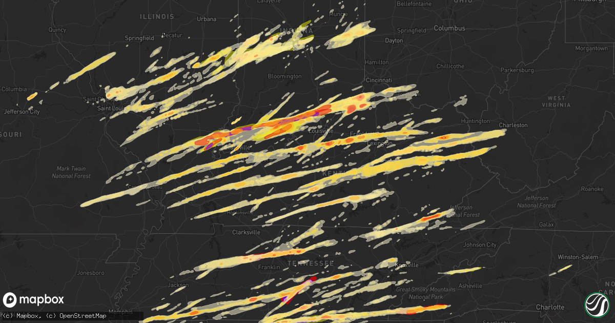
Hail Map in Kentucky on March 2, 2012
Get this storm
March 2 map
$229
one time, instant access
Download today. No call, no setup
Keep the $229
Bought the map and want the full workflow? Apply the entire $229 to a subscription within 7 days. None of it is wasted.
Every map, not just this one
This buys you this map. Subscription and you get every map we run, in the markets you choose from a few cities to whole states to nationwide. Plus real-time alerts the moment a storm fires.
Contact data
Name, contact info, occupancy, even credit band for addresses in the footprint. You go from where it hit to who to call.
Become the source they trust
Unlimited branding weather history reports on demand. You already have the documented answer ready for the property owner, and you are the one who showed up with it.
Property data and RoofTrace estimates
Pull up any address you have got, its value and the exact code rules for that jurisdiction, straight from One Click Code. Then RoofTrace estimates the squares, pitch, and roof value, priced the way you price.
Storm reports in Kentucky
Kentucky
| Date | Description |
|---|---|
| 03/02/20125:58 PM CST | Baseball to apple size hail in downtown campton. |
| 03/02/20125:57 PM CST | A local report indicates 1.00 inch wind near PONGO |
| 03/02/20125:56 PM CST | A local report indicates 1.75 inch wind near WALLINS CREEK |
| 03/02/20125:51 PM CST | Tennis ball sized hail was reported. |
| 03/02/20125:51 PM CST | *** 2 fatal *** a tornado touched down 1 mile east of cutuno and moved east across magoffin...johnson and martin counties kentucky before moving into west virginia. Thi |
| 03/02/20125:50 PM CST | A local report indicates 1.00 inch wind near WALLINS CREEK |
| 03/02/20125:50 PM CST | A nws storm damage survey team found tree damage consistent with an ef-1 tornado along hwy 1094 just southeast of the burkhart community in wolfe county. This is now co |
| 03/02/20125:49 PM CST | A local report indicates 1.00 inch wind near 4 NW BEREA |
| 03/02/20125:45 PM CST | A local report indicates 1.50 inch wind near 3 WSW BLAINE |
| 03/02/20125:45 PM CST | A local report indicates 1.00 inch wind near 2 S CANNEL CITY |
| 03/02/20125:45 PM CST | A local report indicates 1.75 inch wind near PULASKI |
| 03/02/20125:45 PM CST | A local report indicates 2.75 inch wind near 1 W INSULL |
| 03/02/20125:42 PM CST | A local report indicates 1.00 inch wind near BLACKMONT |
| 03/02/20125:40 PM CST | A local report indicates 1.75 inch wind near SCIENCE HILL |
| 03/02/20125:35 PM CST | A local report indicates 1.25 inch wind near LOUISA |
| 03/02/20125:35 PM CST | A swath of baseball to apple size hail fell from downtown campton to the east to near gilmore. |
| 03/02/20125:35 PM CST | Trees were blown down in pineville. |
| 03/02/20125:30 PM CST | Half dollar hail was reported at the county highway garage. |
| 03/02/20125:30 PM CST | A local report indicates 1.75 inch wind near LOUISA |
| 03/02/20125:30 PM CST | Trees were blown down in middlesboro. |
| 03/02/20125:30 PM CST | *** 2 fatal *** confirmed by phone with emergency manager via phone 0800 on 03 03 2012. |
| 03/02/20125:26 PM CST | A local report indicates 2.75 inch wind near 4 N SANDY HOOK |
| 03/02/20125:26 PM CST | A local report indicates 1.50 inch wind near 3 N BEREA |
| 03/02/20125:22 PM CST | 1.5 and 2.0 inch hail. Numerous 3-4 inch diameter trees reported down. |
| 03/02/20125:21 PM CST | A local report indicates 60 MPH wind near 4 W MOREHEAD |
| 03/02/20125:20 PM CST | Spotter reports 1 inch hail. |
| 03/02/20125:18 PM CST | A local report indicates 1.75 inch wind near 5 N RUSSELL SPRINGS |
| 03/02/20125:15 PM CST | Tornado on ground. Also 3 inch diameter hail. |
| 03/02/20125:13 PM CST | Roof damage and vinyl siding damage as well as broken windows from the large hail in the cartersville area.. |
| 03/02/20125:11 PM CST | Covering ground |
| 03/02/20125:10 PM CST | Event occurred between 555 pm and 610 pm. |
| 03/02/20125:10 PM CST | A local report indicates 1.00 inch wind near 2 S CAINS STORE |
| 03/02/20125:10 PM CST | One structure with roof damage. |
| 03/02/20125:10 PM CST | Multiple homes damaged along with car windows broken. |
| 03/02/20125:10 PM CST | A local report indicates 1.75 inch wind near 1 S COMBS |
| 03/02/20125:10 PM CST | A local report indicates 1.00 inch wind near OLIVE HILL |
| 03/02/20125:10 PM CST | Possible |
| 03/02/20125:08 PM CST | An ef1 tornado touched down near the bath county high school. The tornado had a intermittent path to the east-northeast crossing i-64 and causing damage to trees...barn |
| 03/02/20125:06 PM CST | Damage reported at wal mart. |
| 03/02/20125:05 PM CST | A local report indicates 1.75 inch wind near COLUMBIA |
| 03/02/20125:05 PM CST | A local report indicates 62 MPH wind near 8 E RICHMOND |
| 03/02/20125:04 PM CST | Numerous trees and homes damaged. |
| 03/02/20125:01 PM CST | There have been reports of multiple injuries and deaths. |
| 03/02/20125:00 PM CST | Tennis ball sized hail left indentions in the ground. |
| 03/02/20125:00 PM CST | One tree and several limbs down along rt 7 |
| 03/02/20125:00 PM CST | Covered the ground. |
| 03/02/20125:00 PM CST | Small porch ripped off a home |
| 03/02/20124:59 PM CST | A local report indicates 70 MPH wind near 5 N MOUNT STERLING |
| 03/02/20124:59 PM CST | Some trees down near the airport. |
| 03/02/20124:59 PM CST | A local report indicates 1.00 inch wind near 5 N MOUNT STERLING |
| 03/02/20124:58 PM CST | Tornado on the ground in west liberty. |
| 03/02/20124:58 PM CST | Homes and garages damaged. |
| 03/02/20124:56 PM CST | State police reports tornado on the ground just west of west liberty. |
| 03/02/20124:55 PM CST | Significant damage in the judy area. |
| 03/02/20124:55 PM CST | A local report indicates 1.75 inch wind near KIRKSVILLE |
| 03/02/20124:54 PM CST | A local report indicates 1.00 inch wind near EDMONTON |
| 03/02/20124:52 PM CST | A local report indicates 1.75 inch wind near JUNCTION CITY |
| 03/02/20124:51 PM CST | A local report indicates 1.75 inch wind near RICHMOND |
| 03/02/20124:50 PM CST | A local report indicates 1.50 inch wind near 4 NE NORTH MIDDLETOWN |
| 03/02/20124:49 PM CST | Roof off residence and barn at 880 duncannon lane |
| 03/02/20124:49 PM CST | A tool shed destroyed just north of edmonton on don lyle road. A portion of a roof was blown off of a structure on odell-vanzant road. |
| 03/02/20124:49 PM CST | Golf ball hail covered the ground |
| 03/02/20124:48 PM CST | A local report indicates 2.75 inch wind near MUNFORDVILLE |
| 03/02/20124:48 PM CST | Houses damaged from tornado. |
| 03/02/20124:48 PM CST | A local report indicates 1.75 inch wind near WELLINGTON |
| 03/02/20124:47 PM CST | A local report indicates 2.75 inch wind near MUNFORDVILLE |
| 03/02/20124:46 PM CST | A local report indicates 2.00 inch wind near 2 W RICHMOND |
| 03/02/20124:45 PM CST | A local report indicates 60 MPH wind near 5 E MUNFORDVILLE |
| 03/02/20124:45 PM CST | A local report indicates 60 MPH wind near 5 W EDMONTON |
| 03/02/20124:44 PM CST | Tornado was reported on the ground. |
| 03/02/20124:43 PM CST | Trees and lines down with wind estimated at 65 mph |
| 03/02/20124:43 PM CST | Houses damaged in wellington. Golf ball size hail also reported. |
| 03/02/20124:42 PM CST | A local report indicates 1.00 inch wind near KIRKSVILLE |
| 03/02/20124:42 PM CST | A local report indicates 1.75 inch wind near MUNFORDVILLE |
| 03/02/20124:41 PM CST | Golfball size hail covering the ground |
| 03/02/20124:40 PM CST | Barn destroyed from wind damage. |
| 03/02/20124:40 PM CST | Golfball size hail was reported. |
| 03/02/20124:40 PM CST | Golfball sized hail reported near olympia...bethel and sharpsburg. |
| 03/02/20124:40 PM CST | Heavy damage to church on sr 10 |
| 03/02/20124:39 PM CST | *** 8 fatal *** a tornado touched down 2 miles southwest of mariba and moved east across menifee and morgan counties for 34 miles. This tornado hit west liberty kentuck |
| 03/02/20124:39 PM CST | A local report indicates 1.75 inch wind near MUNFORDVILLE |
| 03/02/20124:39 PM CST | Tornado on jim hills road near randolph |
| 03/02/20124:38 PM CST | Power lines down and poles snapped. |
| 03/02/20124:35 PM CST | A local report indicates 1.75 inch wind near GRAVEL SWITCH |
| 03/02/20124:35 PM CST | Half dollar size hail was reported. |
| 03/02/20124:35 PM CST | A local report indicates 1.75 inch wind near 2 E LANCASTER |
| 03/02/20124:32 PM CST | A local report indicates 1.75 inch wind near MEANS |
| 03/02/20124:32 PM CST | A local report indicates 64 MPH wind near BOWLING GREEN |
| 03/02/20124:30 PM CST | Large trees down...gutters ripped away from houses...fence laid over and also a porch damaged on a house. |
| 03/02/20124:29 PM CST | A local report indicates 1.00 inch wind near HAYWOOD |
| 03/02/20124:28 PM CST | A local report indicates 1.00 inch wind near 2 SE MOUNT STERLING |
| 03/02/20124:26 PM CST | A local report indicates 1.75 inch wind near ALTON |
| 03/02/20124:26 PM CST | A local report indicates 1.75 inch wind near 4 N LAWRENCEBURG |
| 03/02/20124:26 PM CST | A local report indicates 1.00 inch wind near GLASGOW |
| 03/02/20124:25 PM CST | A local report indicates 60 MPH wind near GLASGOW |
| 03/02/20124:25 PM CST | Baseball sized hail in jeffersonville. |
| 03/02/20124:25 PM CST | A local report indicates 1.00 inch wind near GEORGETOWN |
| 03/02/20124:23 PM CST | Houses damaged in wellington. Golf ball size hail also reported. |
| 03/02/20124:23 PM CST | Large trees down. Roofs off homes. Time estimated from radar. Possible tornado based on radar. |
| 03/02/20124:23 PM CST | A local report indicates 60 MPH wind near GEORGETOWN |
| 03/02/20124:23 PM CST | A local report indicates 1.75 inch wind near GEORGETOWN |
| 03/02/20124:21 PM CST | Baseball size hail along highway 11 between levee and powell county line. |
| 03/02/20124:20 PM CST | A mobile home blown off foundation. |
| 03/02/20124:20 PM CST | A local report indicates 1.25 inch wind near 2 N CLAY CITY |
| 03/02/20124:15 PM CST | A local report indicates 2.75 inch wind near TRAPP |
| 03/02/20124:12 PM CST | A local report indicates 1.75 inch wind near 10 E CREAL |
| 03/02/20124:10 PM CST | A local report indicates 1.75 inch wind near FRANKFORT |
| 03/02/20124:10 PM CST | A local report indicates 60 MPH wind near 4 W BOWLING GREEN |
| 03/02/20124:10 PM CST | A local report indicates 1.75 inch wind near ALTON |
| 03/02/20124:10 PM CST | A local report indicates 60 MPH wind near 3 NW HOLY CROSS |
| 03/02/20124:08 PM CST | Media reports trailers damaged...power lines down and light poles down near aa ky highway near flagg spring |
| 03/02/20124:08 PM CST | A local report indicates 1.75 inch wind near FRANKFORT |
| 03/02/20124:07 PM CST | Power line down |
| 03/02/20124:07 PM CST | A local report indicates 1.75 inch wind near 3 SW FRANKFORT |
| 03/02/20124:07 PM CST | Straight-line winds destroyed a barn just southeast of cave springs. Also had minor roof siding damage to a home in the area along with severeal trees down. Peak wind s |
| 03/02/20124:06 PM CST | Ef1 tornado dropped down along highway 961 east of alvaton in warren county. It destroyed a barn and a tool shed with winds estimated at 95 mph. |
| 03/02/20124:05 PM CST | A local report indicates 1.00 inch wind near 4 N BEREA |
| 03/02/20124:05 PM CST | Ef1 tornado dropped down along highway 961 east of alvaton in warren county. It destroyed a barn and a tool shed with winds estimated at 95 mph. |
| 03/02/20124:04 PM CST | A local report indicates 1.75 inch wind near WADDY |
| 03/02/20124:02 PM CST | Roof damage |
| 03/02/20124:02 PM CST | A local report indicates 1.00 inch wind near WADDY |
| 03/02/20124:02 PM CST | Numerous treetops snapped off and trees down...as well as 8 to 10 buildings severely damaged along a path encompassing berlin...powersville...brooksville...and germanto |
| 03/02/20124:00 PM CST | A local report indicates 1.00 inch wind near WADDY |
| 03/02/20123:59 PM CST | The emergency manager reported that tennis ball sized hail damaged numerous buildings and cars in mount eden...which is on the spencer anderson county line. |
| 03/02/20123:56 PM CST | A local report indicates 1.25 inch wind near SHELBYVILLE |
| 03/02/20123:56 PM CST | A local report indicates 62 MPH wind near SHELBYVILLE |
| 03/02/20123:55 PM CST | On hwy 357 s... One mile south of hwy 728... A single-wide mobile home was destroyed... With the roof and most of the exterior siding gone. |
| 03/02/20123:55 PM CST | Wind gust measured at the kentucky mesonet site in owen county. |
| 03/02/20123:55 PM CST | A local report indicates 1.75 inch wind near TAYLORSVILLE |
| 03/02/20123:54 PM CST | Lsr |
| 03/02/20123:53 PM CST | Lsr |
| 03/02/20123:53 PM CST | Trees and power lines down. |
| 03/02/20123:53 PM CST | Trees down. |
| 03/02/20123:50 PM CST | Two trees down. |
| 03/02/20123:49 PM CST | A local report indicates 83 MPH wind near FORT CAMPBELL NORTH |
| 03/02/20123:49 PM CST | Tree fell on a house at 138 n maple st |
| 03/02/20123:48 PM CST | Large shallow rooted hardwood tree uprooted |
| 03/02/20123:45 PM CST | Trees down |
| 03/02/20123:45 PM CST | A local report indicates 1.75 inch wind near BRYANTSVILLE |
| 03/02/20123:44 PM CST | Garage heavily damaged on parkers grove rd |
| 03/02/20123:43 PM CST | Possible tornado damaged 18 homes and destroyed 2 near peach grove. Also a church building destroyed. Time estimated from radar. |
| 03/02/20123:43 PM CST | A local report indicates 70 MPH wind near ELK CREEK |
| 03/02/20123:42 PM CST | Possible tornado damaged or destroyed around 50 houses or more as it tracked along the pendleton/campbell county line. Time estimated from radar. |
| 03/02/20123:41 PM CST | A local report indicates 62 MPH wind near 4 S ELIZABETHTOWN |
| 03/02/20123:40 PM CST | Pockets of widespread damage...including some reports of injuries. Specific locations not known at this time. Report from dry ridge state police post. |
| 03/02/20123:40 PM CST | A local report indicates 2.50 inch wind near MOUNT WASHINGTON |
| 03/02/20123:36 PM CST | Many trees snapped. Church destroyed. Mobile home damaged. Damage occurred in morning view. |
| 03/02/20123:35 PM CST | Several reports of damage caused by possible tornado...including trailer destroyed as well as silo and barn damage. |
| 03/02/20123:35 PM CST | A local report indicates 1.75 inch wind near MOUNT WASHINGTON |
| 03/02/20123:35 PM CST | 1 foot to 2 foot pieces of plywood fallnig from the sky |
| 03/02/20123:33 PM CST | A local report indicates 1.75 inch wind near 5 E SHEPHERDSVILLE |
| 03/02/20123:32 PM CST | Semi blown over at mile marker 95 on interstae 65. |
| 03/02/20123:32 PM CST | Possible tornado. Barn and home destroyed. Tractor trailer pushed on its side. High tension structure damaged. Trees snapped. Possibly 3 injuries. Most damage near the |
| 03/02/20123:31 PM CST | A local report indicates 2.50 inch wind near BROMLEY |
| 03/02/20123:30 PM CST | Reported near four corners. |
| 03/02/20123:30 PM CST | Spotter report of extensive structural damage north of long ridge. Possible injuries. |
| 03/02/20123:30 PM CST | Straight-lined winds downed a few trees on deer lick road. Wind speeds estimated at 60 mph. Survey done by nws nashville. |
| 03/02/20123:29 PM CST | Some reports of structural damage also in new liberty but not specific at this time |
| 03/02/20123:28 PM CST | A local report indicates 1.75 inch wind near SHEPHERDSVILLE |
| 03/02/20123:27 PM CST | A local report indicates 1.00 inch wind near DRY RIDGE |
| 03/02/20123:26 PM CST | Dime size hail reported with this storm along pennyrile parkway and hwy 80. |
| 03/02/20123:25 PM CST | Near jonesville. |
| 03/02/20123:22 PM CST | A local report indicates 1.75 inch wind near CANEYVILLE |
| 03/02/20123:21 PM CST | Vacant mobile home was turned over from straight line winds. Power outages across the county as well. |
| 03/02/20123:21 PM CST | *** 1 inj *** |
| 03/02/20123:20 PM CST | A local report indicates 60 MPH wind near CANEYVILLE |
| 03/02/20123:18 PM CST | A local report indicates 1.75 inch wind near LEITCHFIELD |
| 03/02/20123:17 PM CST | A local report indicates 1.75 inch wind near GRAVEL SWITCH |
| 03/02/20123:17 PM CST | Several six inch limbs were down 2 miles east of port royal on route 389. |
| 03/02/20123:15 PM CST | At renfrow |
| 03/02/20123:14 PM CST | Time estimated by radar. |
| 03/02/20123:13 PM CST | Thunderstorm winds caused power poles to lean on bishops lane east of campbellsburg. |
| 03/02/20123:12 PM CST | Trees down |
| 03/02/20123:12 PM CST | Tree damage |
| 03/02/20123:10 PM CST | Debris falling out of the sky. No tornado sighted at this location by this spotter. |
| 03/02/20123:09 PM CST | A local report indicates 1.25 inch wind near DOE VALLEY |
| 03/02/20123:08 PM CST | A local report indicates a tornado near 5 NW FORT KNOX |
| 03/02/20123:07 PM CST | A local report indicates 60 MPH wind near BRANDENBURG |
| 03/02/20123:06 PM CST | A local report indicates 2.75 inch wind near BRANDENBURG |
| 03/02/20123:05 PM CST | From the kentucky mesonet site. |
| 03/02/20123:05 PM CST | Time estimated from radar. |
| 03/02/20123:04 PM CST | At the intersection of hwy 55 and hwy 389 - relayed from wfo louisville |
| 03/02/20123:03 PM CST | On hi-grove hill road... There was a very concentrated area of snapped trees. A power line was down... And a gutter was partially ripped off a garage. |
| 03/02/20123:03 PM CST | On hi-grove hill road... There was a very concentrated area of snapped trees. A power line was down... And a gutter was partially ripped off a garage. |
| 03/02/20123:02 PM CST | Ef0 on us 60 near guston and hill grove |
| 03/02/20123:01 PM CST | Ef1 tornado touched down on willard wilson road and traveled east northeast to at least carmon creek road. An aerial survey is being conducted to see if this tornado tr |
| 03/02/20123:01 PM CST | A 30 by 60 foot old barn and a single-wide home were destroyed on willard wilson road. One large oak tree was downed along with several other smaller trees. Further dow |
| 03/02/20123:01 PM CST | A 30 by 60 foot old barn and a single-wide home were destroyed on willard wilson road. One large oak tree was downed along with several other smaller trees. Further dow |
| 03/02/20123:00 PM CST | A local report indicates 1.25 inch wind near CARROLLTON |
| 03/02/20123:00 PM CST | Funnel cloud spotted. |
| 03/02/20123:00 PM CST | Roofs off homes. |
| 03/02/20122:57 PM CST | Barn and silo damage...structural damage to outbuilding and several power lines down on highway 276. |
| 03/02/20122:56 PM CST | Roofs off homes and cars overturned. |
| 03/02/20122:56 PM CST | Reported on ky mesonet. |
| 03/02/20122:55 PM CST | Pea size hail reported with this storm. |
| 03/02/20122:53 PM CST | Barn totally destroyed - fairview road. |
| 03/02/20122:52 PM CST | Roof completely ripped off house/garage - hwy 81. |
| 03/02/20122:52 PM CST | Large shed destroyed near hwy 175 near lynn city rd. |
| 03/02/20122:51 PM CST | Muliple reports of tornado along lind city road. |
| 03/02/20122:51 PM CST | Dime size hail reported with the storm along with downed trees. |
| 03/02/20122:51 PM CST | At least 8 to 10 houses reported to have significant damage on kings ridge rd. 1 home destroyed. Numerous trees and wires down. All damage reported to be in a 3 to 4 bl |
| 03/02/20122:50 PM CST | Roof removed from barn near millport at hwy 175 near hwy 423 intersection. |
| 03/02/20122:50 PM CST | Late report...roof blown off of home. Fire/rescue is responding. |
| 03/02/20122:50 PM CST | Golf ball size hail damaged roof of homes along princeton road and stone road. Late report. |
| 03/02/20122:47 PM CST | Spotters report tornado on the ground near kingdale road in western carroll county. |
| 03/02/20122:47 PM CST | Ef2. Path length 5 miles. Path width 60 to 200 yards. Wind speed 95 to 120 mph. Two structures destroyed on new bethel cloverport road. Tree damage and two chicken barn |
| 03/02/20122:46 PM CST | At least 8 to 10 houses reported to have significant damage on kings ridge rd. 1 home destroyed. Numerous trees and wires down. All damage reported to be in a 3 to 4 bl |
| 03/02/20122:46 PM CST | Fire department damaged. |
| 03/02/20122:44 PM CST | Ef0. Path length 120 yds. Path width 30 yds. Near the swan lake estates a 30 by 60 metal building was damaged. Eyewitness reported a small rope tornado was observed. |
| 03/02/20122:43 PM CST | Ef2 tornado from hancock co entered breckinridge co 1.8 w cloverport. Lifted 9.5 e cloverport. |
| 03/02/20122:42 PM CST | Dime size hail reported with this storm. |
| 03/02/20122:41 PM CST | Ef3 tornado began 5 mi s of milton and lifted just east of monitor on county line |
| 03/02/20122:40 PM CST | Reported by ky mesonet. |
| 03/02/20122:40 PM CST | A local report indicates a tornado near MILTON |
| 03/02/20122:40 PM CST | Home on jaygeo street lost back of roof and the other side is peeled back. Time estimated. Roof of the ky trans. Cabinet district 2 headquarters ripped off. Several hwy |
| 03/02/20122:39 PM CST | Golf ball size hail reported. |
| 03/02/20122:38 PM CST | Ef2 tornado with 1.7 mile path from oh river near trout to 5 nw bedford |
| 03/02/20122:38 PM CST | Ef2 touched down 4.5 ssw hawesville and continued into breckinridge co 1.8 w cloverport. |
| 03/02/20122:37 PM CST | Roof and tree damage reported in the community. Several sections of town without power. |
| 03/02/20122:37 PM CST | Gofl ball size hail reported along with wind gusts estimated 60 mph. |
| 03/02/20122:35 PM CST | Quarter size hail reported. Damage to gas station canopy and signs reported. |
| 03/02/20122:34 PM CST | *** 2 inj *** ef4 tornado with 49 mile track from washington co in to trimble co entered trimble co 7.2 nw bedford and lifted 3.9 nnw bedford |
| 03/02/20122:28 PM CST | Power lines down. |
| 03/02/20122:25 PM CST | A local report indicates 76 MPH wind near OWENSBORO |
| 03/02/20122:25 PM CST | Reported near eastview elementary school off hwy 405. |
| 03/02/20122:25 PM CST | Half dollar hail reported in the community of beach grove. |
| 03/02/20122:22 PM CST | Tornado reported near 25th street in owensboro proper. |
| 03/02/20122:21 PM CST | Nickel to quarter size hail reported in the community. |
| 03/02/20122:15 PM CST | Late report. Golf ball size hail reported. |
| 03/02/20122:10 PM CST | Very large tornado reported by storm chaser just outside of the community of clay. |
| 03/02/20122:10 PM CST | Public report of shingles blown off a home. |
| 03/02/20122:08 PM CST | Golf ball size hail reported. |
| 03/02/20122:05 PM CST | Tornado spotted by trained spotter on east side of community. Numerous power flashes and loud roar. |
| 03/02/20122:02 PM CST | A local report indicates 1.75 inch wind near HENDERSON |
| 03/02/20122:00 PM CST | Golf ball size hail reported. |
| 03/02/20121:55 PM CST | A local report indicates 1.75 inch wind near 2 E CORYDON |
| 03/02/20121:55 PM CST | Wind gusts estimated 60 to 70 mph near lourdes hospital at exit 7. |
| 03/02/20121:52 PM CST | Quarter size hail reported by state police. |
| 03/02/20121:43 PM CST | Quarter size hail reported on south side of town as well as downtown. |
| 03/02/20121:40 PM CST | Golf ball size hail reported. |
| 03/02/20121:38 PM CST | Roof blown off of home and laying across highway 268 just west of hwy 62 intersection. |
| 03/02/20121:33 PM CST | Measured at barkley regional airport asos. |
| 03/02/20121:30 PM CST | Part of roof barn blown off between possum trot and reidland. Late report. |
| 03/02/201212:00 PM CST | 2 trees down in georgetown |
| 03/01/20127:40 PM CST | A local report indicates 1.25 inch wind near MIDDLESBORO |
| 03/01/20127:25 PM CST | Quarter sized hail reported was reported by the public |
| 03/01/20127:10 PM CST | A local report indicates 1.25 inch wind near FONDE |
| 03/01/20127:00 PM CST | Trees were blown down in arjay. |
| 03/01/20126:40 PM CST | Significant damage in eastern sections of martin county near the lovely and beauty communities. |
| 03/01/20126:39 PM CST | Dispatch reported quarter sized hail and strong winds. |
| 03/01/20126:38 PM CST | A local report indicates 1.00 inch wind near INEZ |
| 03/01/20126:32 PM CST | Damage to the second story of a brick home. Time of event was estimated from radar. |
| 03/01/20126:30 PM CST | Two story brick building damaged and several huge trees down. |
| 03/01/20126:26 PM CST | A local report indicates 1.75 inch wind near PAINTSVILLE |
| 03/01/20126:25 PM CST | A local report indicates 1.25 inch wind near FONDE |
| 03/01/20126:23 PM CST | Event occurred between 708 and 723 pm. |
| 03/01/20126:20 PM CST | 10 to 20 houses and a former church with roofs blown off on a 3 mile stretch of rt 302. |
| 03/01/20126:20 PM CST | House blown onto road blocking hwy 825. Two different appartment buildings callapsed...one onto hwy 321 and the other on hwy 1428. |
| 03/01/20126:19 PM CST | Church building destroyed and mobile homes severely damaged or destroyed. Time of event is estimated. |
| 03/01/20126:17 PM CST | A local report indicates 2.75 inch wind near LENARVE |
| 03/01/20126:17 PM CST | Mostly golf ball size hail occurred but hail up to hen egg size fell and hail covered the ground to a depth of about two inches. |
| 03/01/20126:17 PM CST | Tornado blew truck off road near the 49 mile marker 3 miles north of the rockcastle county line. |
| 03/01/20126:17 PM CST | A local report indicates 1.75 inch wind near 1 W PAINTSVILLE |
| 03/01/20126:15 PM CST | A local report indicates 1.75 inch wind near PAINTSVILLE |
| 03/01/20126:15 PM CST | Roof damage to the paintsville high school was reported. Time of event is estimated from radar. |
| 03/01/20126:15 PM CST | A doublewide mobile home was reported to have been destroyed near leander. Time of event is estimated from radar. |
| 03/01/20126:15 PM CST | A local report indicates 1.00 inch wind near NOETOWN |
| 03/01/20126:14 PM CST | On the ground |
| 03/01/20126:10 PM CST | Advanced auto roof ripped off. Rescue squad flipped with active power lines on unit. Tornado on the ground. |
| 03/01/20126:10 PM CST | Tree down on vehicle. |
| 03/01/20126:10 PM CST | Multiple mobile homes damaged on little county road. |
| 03/01/20126:10 PM CST | Near laurel/rockcastle line...the tornado was moving east. |
| 03/01/20126:05 PM CST | Trees down on hwy 522. |
| 03/01/20126:05 PM CST | *** 5 fatal *** a tornado touched down 4.3 miles west of east bernstadt and moved northeast before lifting 3.6 miles nne of east bernstadt. Path length was 6.3 miles. T |
| 03/01/20126:05 PM CST | Power poles down at hwy 80 and i-75 interchange. |
| 03/01/20126:04 PM CST | A local report indicates 1.75 inch wind near OIL SPRINGS |
| 03/01/20126:03 PM CST | A local report indicates 58 MPH wind near 2 N MONTICELLO |
| 03/01/20126:03 PM CST | A local report indicates 1.00 inch wind near OIL SPRINGS |
| 03/01/20126:02 PM CST | Semi flipped off of i-75 north between mile markers 46 and 47...damage to houses seen just off of the interstate behind the flipped semi. |
| 03/01/20126:02 PM CST | Roofs blown off apartment buildings. |
| 03/01/20126:00 PM CST | State police reported golf ball sized hail in the city of harlan. |
| 03/01/20126:00 PM CST | A local report indicates 1.00 inch wind near 3 SSE HARLAN |
| 03/01/20126:00 PM CST | A local report indicates 2.00 inch wind near GRAYS KNOB |
All States Impacted by Hail Map on March 2, 2012
Cities Impacted by Hail Map on March 2, 2012
- Starkville, MS
- Oakdale, IL
- Coulterville, IL
- Salyersville, KY
- West Liberty, KY
- Cannel City, KY
- Saint Charles, MO
- Bowling Green, KY
- Rockfield, KY
- Amory, MS
- Aberdeen, MS
- Okolona, MS
- Fyffe, AL
- Geraldine, AL
- Sewanee, TN
- Winchester, TN
- Johnsonville, IL
- Iuka, IL
- Ladoga, IN
- Roachdale, IN
- Morris, AL
- Pinson, AL
- Ashville, AL
- Jacksonville, AL
- Ohatchee, AL
- Wellington, AL
- Holcomb, MS
- Unionville, TN
- Readyville, TN
- Lewisburg, TN
- Rockvale, TN
- Murfreesboro, TN
- Bradyville, TN
- Beechgrove, TN
- Bell Buckle, TN
- Christiana, TN
- Woodbury, TN
- Mcminnville, TN
- Chapel Hill, TN
- Anguilla, MS
- Richmond, IN
- Keyesport, IL
- Smithboro, IL
- Greenville, IL
- Mason, IL
- Watson, IL
- Effingham, IL
- Altamont, IL
- Brownstown, IL
- Saint Elmo, IL
- Pelahatchie, MS
- Brandon, MS
- Morton, MS
- Ethridge, TN
- Saint Anthony, IN
- Huntingburg, IN
- Birdseye, IN
- Dubois, IN
- Jasper, IN
- Celestine, IN
- Mount Vernon, IN
- Sandy Hook, KY
- Isonville, KY
- Gallipolis, OH
- Thurman, OH
- Patriot, OH
- Gallipolis Ferry, WV
- Henderson, WV
- Bidwell, OH
- Oak Hill, OH
- Point Pleasant, WV
- Cedarbluff, MS
- Pheba, MS
- Gate City, VA
- Weber City, VA
- Hiltons, VA
- Staunton, IL
- Gillespie, IL
- Wilsonville, IL
- Benld, IL
- Bunker Hill, IL
- Sawyerville, IL
- Mount Olive, IL
- Newcomb, TN
- Jellico, TN
- Williamsburg, KY
- Tupelo, MS
- Mooreville, MS
- Thomasville, AL
- Pine Hill, AL
- Camden, AL
- Coy, AL
- Coffeeville, AL
- Grove Hill, AL
- Lower Peach Tree, AL
- Scottsville, KY
- Pitkin, LA
- Richmond, KY
- Stanton, KY
- Winchester, KY
- Frenchburg, KY
- Means, KY
- Jeffersonville, KY
- Clay City, KY
- Pontotoc, MS
- Murphysboro, IL
- Waverly, TN
- Carthage, TN
- White Bluff, TN
- Elmwood, TN
- Kingston Springs, TN
- Holladay, TN
- Hermitage, TN
- Nashville, TN
- New Johnsonville, TN
- Burns, TN
- Mount Juliet, TN
- Lebanon, TN
- Pegram, TN
- Dickson, TN
- McEwen, TN
- Camden, TN
- Watertown, TN
- Fairview, TN
- Gordonsville, TN
- Hurricane Mills, TN
- Baskin, LA
- Delhi, LA
- Millstadt, IL
- Columbia, IL
- Belleville, IL
- Dupo, IL
- East Carondelet, IL
- Lawrenceburg, TN
- Savannah, TN
- Loretto, TN
- Westpoint, TN
- Leoma, TN
- Pulaski, TN
- Collinwood, TN
- Lutts, TN
- Iron City, TN
- Waterloo, AL
- Cypress Inn, TN
- Bessemer, AL
- New Ross, IN
- Advance, IN
- Russellville, IN
- Jamestown, IN
- Cohutta, GA
- Crandall, GA
- Dalton, GA
- New Market, AL
- Ardmore, TN
- Taft, TN
- Fayetteville, TN
- Ardmore, AL
- Kelso, TN
- Hazel Green, AL
- Athens, AL
- Elkmont, AL
- Toney, AL
- Enid, MS
- Pope, MS
- Etta, MS
- Guntown, MS
- Batesville, MS
- New Albany, MS
- Oxford, MS
- Blue Springs, MS
- Thaxton, MS
- Water Valley, MS
- Courtland, MS
- Baldwyn, MS
- Taylor, MS
- Myrtle, MS
- Georgetown, OH
- Poseyville, IN
- Manchester, TN
- Beech Bluff, TN
- Jackson, TN
- Medon, TN
- Grantsburg, IN
- English, IN
- Hartselle, AL
- Danville, AL
- Oliver Springs, TN
- Cub Run, KY
- Mammoth Cave, KY
- Flintstone, GA
- Rossville, GA
- Gattman, MS
- Detroit, AL
- Sulligent, AL
- Greenwood Springs, MS
- Fayette, AL
- Vernon, AL
- Kennedy, AL
- Elizabethtown, IN
- Westport, IN
- Greensburg, IN
- Hartsville, IN
- Columbus, IN
- Bedford, KY
- Hanover, IN
- Nabb, IN
- Scottsburg, IN
- Milton, KY
- Lexington, IN
- Houston, OH
- Piqua, OH
- Covington, OH
- Clay City, IL
- Dix, IL
- Kell, IL
- Texico, IL
- Centre, AL
- Lewisburg, KY
- Dunmor, KY
- Belton, KY
- Greenville, KY
- Elkton, KY
- Estill Springs, TN
- Lascassas, TN
- Mooreland, IN
- New Castle, IN
- Losantville, IN
- Killen, AL
- Florence, AL
- Cherokee, AL
- Warren, IN
- Grant, AL
- Hillsboro, IL
- Livingston, IL
- Moro, IL
- South Roxana, IL
- Beecher City, IL
- Roxana, IL
- East Alton, IL
- Wood River, IL
- Saint Louis, MO
- West Alton, MO
- Hamel, IL
- Fillmore, IL
- Florissant, MO
- Cowden, IL
- Edwardsville, IL
- Granite City, IL
- Cottage Hills, IL
- Worden, IL
- Ramsey, IL
- Coffeen, IL
- Bingham, IL
- Sorento, IL
- Bethalto, IL
- Hartford, IL
- Alton, IL
- Herrick, IL
- Godfrey, IL
- Alhambra, IL
- Dorsey, IL
- New Douglas, IL
- Donnellson, IL
- Toxey, AL
- Campbell, AL
- Dixons Mills, AL
- Silas, AL
- Arlington, AL
- Gilbertown, AL
- Glasgow, KY
- Cromwell, KY
- Horse Branch, KY
- Beaver Dam, KY
- Leitchfield, KY
- Caneyville, KY
- Millwood, KY
- Sweet Water, AL
- Bastrop, LA
- Tuckasegee, NC
- Franklin, NC
- Sylva, NC
- Glenville, NC
- Cullowhee, NC
- Dixon, KY
- Clay, KY
- Winnsboro, LA
- Mangham, LA
- Waverly, KY
- Crawford, MS
- Columbus, MS
- Joelton, TN
- Ashland City, TN
- Farmerville, LA
- Simsboro, LA
- Ruston, LA
- Sterlington, LA
- Choudrant, LA
- Gibsland, LA
- Arcadia, LA
- Marion, LA
- Dubach, LA
- Downsville, LA
- Louisa, KY
- Morehead, KY
- Wayne, WV
- Fort Gay, WV
- Grayson, KY
- Webbville, KY
- Clearfield, KY
- Catlettsburg, KY
- Olive Hill, KY
- Prichard, WV
- Salt Lick, KY
- Coalmont, TN
- Beersheba Springs, TN
- Palmer, TN
- Dunlap, TN
- Gruetli Laager, TN
- Pikeville, TN
- Altamont, TN
- Rogersville, AL
- Muscle Shoals, AL
- Gipsy, MO
- Greenville, MO
- Lowndes, MO
- Marble Hill, MO
- Zalma, MO
- Evansville, IN
- Kennesaw, GA
- Acworth, GA
- London, KY
- East Bernstadt, KY
- Hamlin, WV
- Myra, WV
- Branchland, WV
- Hulen, KY
- Evarts, KY
- Pineville, KY
- Wallins Creek, KY
- Ages Brookside, KY
- Kenvir, KY
- Miracle, KY
- Coalgood, KY
- Cawood, KY
- Grays Knob, KY
- Mary Alice, KY
- Pathfork, KY
- Middlesboro, KY
- Harlan, KY
- Gulston, KY
- Duck Hill, MS
- Hamilton, AL
- Woodland, MS
- Mantee, MS
- Beaverton, AL
- Hamilton, MS
- Gore Springs, MS
- Nettleton, MS
- Vardaman, MS
- Eupora, MS
- Maben, MS
- Prairie, MS
- Smithville, MS
- Calhoun City, MS
- Stewart, MS
- West Point, MS
- Bellefontaine, MS
- Houston, MS
- Lebanon Junction, KY
- Shepherdsville, KY
- Westfield, IL
- Toledo, IL
- Kansas, IL
- Charleston, IL
- Casey, IL
- Ashmore, IL
- Lerna, IL
- Trilla, IL
- Quitman, LA
- Bienville, LA
- Trussville, AL
- Springville, AL
- Shannon, MS
- New Liberty, KY
- Jonesville, KY
- Dry Ridge, KY
- Sanders, KY
- Sparta, KY
- Glencoe, KY
- Williamsport, KY
- Thelma, KY
- Beattyville, KY
- West Van Lear, KY
- Rogers, KY
- Oil Springs, KY
- Mize, KY
- Tomahawk, KY
- Meally, KY
- Hazel Green, KY
- Paintsville, KY
- Tutor Key, KY
- Staffordsville, KY
- Boons Camp, KY
- Campton, KY
- Slade, KY
- Hagerhill, KY
- Pine Ridge, KY
- Philadelphia, TN
- Niota, TN
- Soddy Daisy, TN
- Decatur, TN
- Sale Creek, TN
- Ten Mile, TN
- Athens, TN
- Sweetwater, TN
- Greenback, TN
- Evensville, TN
- Vonore, TN
- Loudon, TN
- Graysville, TN
- Dayton, TN
- Madisonville, TN
- Berry, AL
- Oakman, AL
- Parrish, AL
- Mount Sterling, KY
- Paris, KY
- Winfield, TN
- Oneida, TN
- Marshall, IN
- Rockville, IN
- Chattanooga, TN
- Pleasant Hill, LA
- Coushatta, LA
- Jonesboro, LA
- Winnfield, LA
- Goldonna, LA
- Robeline, LA
- Pelican, LA
- Dodson, LA
- Campti, LA
- Saline, LA
- Michie, TN
- Shiloh, TN
- Ramer, TN
- Selmer, TN
- Guys, TN
- Stantonville, TN
- Scottsboro, AL
- Birmingham, AL
- Dallas, GA
- Edmonton, KY
- Lynnville, TN
- Summertown, TN
- Jasper, TX
- Wiergate, TX
- Newton, TX
- Burkeville, TX
- Rockport, IN
- Olla, LA
- Mississippi State, MS
- Sharpsburg, KY
- Carlisle, KY
- Gardendale, AL
- Murphy, NC
- Prospect, TN
- Gurley, AL
- Middleton, TN
- Hillsboro, TN
- Ocoee, TN
- Meridianville, AL
- Ringgold, GA
- Holly Springs, MS
- Andrews, NC
- Topton, NC
- Harriman, TN
- McDonald, TN
- Decherd, TN
- Harvest, AL
- Sherwood, TN
- Frankewing, TN
- Normandy, TN
- Tuscumbia, AL
- Sardis, TN
- Leighton, AL
- Hollywood, AL
- Cleveland, TN
- Rockwood, TN
- Shelbyville, TN
- Fort Oglethorpe, GA
- Fackler, AL
- Culleoka, TN
- Morris Chapel, TN
- Saltillo, TN
- Saulsbury, TN
- Adamsville, TN
- Iuka, MS
- Tishomingo, MS
- Counce, TN
- Moscow, TN
- Bryant, AL
- Whitwell, TN
- Sequatchie, TN
- Belfast, TN
- Wildwood, GA
- Marble, NC
- Crump, TN
- Hixson, TN
- Grand Junction, TN
- Harrison, TN
- Farner, TN
- Petersburg, TN
- Benton, TN
- Dennis, MS
- Madison, AL
- Huntland, TN
- Reliance, TN
- Waynesboro, TN
- Stevenson, AL
- Rossville, TN
- Elora, TN
- Byhalia, MS
- Spring City, TN
- Cowan, TN
- Bethel Springs, TN
- Red Banks, MS
- Flat Rock, AL
- Turtletown, TN
- Copperhill, TN
- Courtland, AL
- Old Fort, TN
- Morrison, TN
- Ooltewah, TN
- Whiteside, TN
- Lookout Mountain, GA
- Jasper, TN
- Belvidere, TN
- South Pittsburg, TN
- Cornersville, TN
- Flintville, TN
- Hornsby, TN
- Woodville, AL
- Estillfork, AL
- Trenton, GA
- Town Creek, AL
- Grandview, TN
- Huntsville, AL
- Wartrace, TN
- Pocahontas, TN
- Signal Mountain, TN
- Lamar, MS
- Dellrose, TN
- Pelham, TN
- La Grange, TN
- Spencer, TN
- Sheffield, AL
- Monteagle, TN
- Bridgeport, AL
- Olivehill, TN
- Rock Island, TN
- Lester, AL
- Mulberry, TN
- Hayesville, NC
- Hillsboro, AL
- Guild, TN
- Crossville, TN
- Tracy City, TN
- Apison, TN
- Lookout Mountain, TN
- Paint Rock, AL
- Tanner, AL
- Russellville, AL
- Foster, KY
- Greenville, MS
- Lake Village, AR
- Mount Eden, KY
- Walnut Hill, IL
- Odin, IL
- Nashville, IL
- Centralia, IL
- Salem, IL
- Addieville, IL
- Hoyleton, IL
- Shelbyville, KY
- Owensboro, KY
- Morganfield, KY
- Calhoun, KY
- Sebree, KY
- Nebo, KY
- Pittsboro, MS
- Houlka, MS
- Durant, MS
- Vaiden, MS
- Mathiston, MS
- Hollandale, MS
- Millport, AL
- Silver City, MS
- Louise, MS
- Tchula, MS
- Ackerman, MS
- Kilmichael, MS
- Lexington, MS
- West, MS
- Coila, MS
- Ethel, MS
- Steens, MS
- Weir, MS
- French Camp, MS
- Cruger, MS
- Belzoni, MS
- Sturgis, MS
- Fulton, MO
- Science Hill, KY
- Somerset, KY
- Guntersville, AL
- Stonington, IL
- Taylorville, IL
- Palmer, IL
- Morrisonville, IL
- North Salem, IN
- Salem, IN
- Pekin, IN
- Sharon Grove, KY
- Indianola, MS
- Crossett, AR
- Portland, AR
- Doddsville, MS
- Moorhead, MS
- Hamburg, AR
- Dermott, AR
- Leland, MS
- Montrose, AR
- Inverness, MS
- Shaw, MS
- Itta Bena, MS
- Uniontown, KY
- Henderson, KY
- Corydon, KY
- Oak Grove, LA
- Sturgis, KY
- Utica, KY
- Farina, IL
- Shoals, IN
- Columbia, LA
- Olney, IL
- Noble, IL
- Carmi, IL
- Indianapolis, IN
- Avon, IN
- Carmel, IN
- Center, TX
- Leesville, LA
- Anacoco, LA
- Evans, LA
- Campbellsburg, IN
- Pana, IL
- Tower Hill, IL
- Vanceburg, KY
- Stout, OH
- Jena, LA
- Jonesville, LA
- Grayson, LA
- Rayville, LA
- Monroe, LA
- Chatham, LA
- Vicksburg, MS
- Redwood, MS
- Bolton, MS
- Tallulah, LA
- Bentonia, MS
- Sikes, LA
- Columbia, KY
- Alexander City, AL
- Jamestown, TN
- Borden, IN
- Yazoo City, MS
- Rolling Fork, MS
- Morgantown, KY
- La Fontaine, IN
- Converse, IN
- Amboy, IN
- Celina, TN
- Tompkinsville, KY
- Burkesville, KY
- Paris, IL
- Owingsville, KY
- Greenwood, IN
- Holton, IN
- North Vernon, IN
- Butlerville, IN
- Scipio, IN
- Gays, IL
- Windsor, IL
- Woodstock, AL
- West Blocton, AL
- Bethel, OH
- New Richmond, OH
- Moscow, OH
- California, KY
- Alexandria, KY
- Gravel Switch, KY
- Parksville, KY
- Bradfordsville, KY
- Lebanon, KY
- Homer, LA
- Bernice, LA
- Marion, IN
- Waterford, MS
- Potts Camp, MS
- Nancy, KY
- Hartsville, TN
- Castalian Springs, TN
- Bethpage, TN
- Whitleyville, TN
- Moss, TN
- Gallatin, TN
- Gamaliel, KY
- Dixon Springs, TN
- Lafayette, TN
- Red Boiling Springs, TN
- Greenup, IL
- Mattoon, IL
- Martinsville, IL
- Neoga, IL
- Winchester, OH
- Michigan City, MS
- Ashland, MS
- Mount Washington, KY
- Bardstown, KY
- Deatsville, AL
- Titus, AL
- Marbury, AL
- Holly Pond, AL
- New Hope, KY
- Loretto, KY
- New Haven, KY
- Ekron, KY
- Brandenburg, KY
- Guston, KY
- Irvington, KY
- South Shore, KY
- Pedro, OH
- Greenup, KY
- Franklin Furnace, OH
- Wheelersburg, OH
- South Webster, OH
- New Harmony, IN
- Crossville, IL
- Genoa, WV
- Wellington, KY
- East Lynn, WV
- Waco, KY
- Ezel, KY
- Dunlow, WV
- Elkfork, KY
- Adams, KY
- Martha, KY
- Blaine, KY
- Breese, IL
- Trenton, IL
- Aviston, IL
- Carlyle, IL
- Tunnel Hill, GA
- Hillsdale, IN
- Dana, IN
- Chrisman, IL
- Taylorsville, KY
- Knightsville, IN
- Staunton, IN
- Brazil, IN
- Buchanan, GA
- Cedartown, GA
- Whiteville, TN
- Bolivar, TN
- Somerville, TN
- Dawson, AL
- Warsaw, KY
- Florence, IN
- Patriot, IN
- Rising Sun, IN
- Vevay, IN
- Ghent, KY
- Owenton, KY
- Carrollton, KY
- Turners Station, KY
- Worthville, KY
- Campbellsburg, KY
- West Newton, IN
- Camby, IN
- Burnside, KY
- Bronston, KY
- Martinsville, IN
- Bentley, LA
- Pollock, LA
- Booneville, KY
- Lebanon, IN
- Rineyville, KY
- Ellsinore, MO
- Bainbridge, IN
- Greencastle, IN
- Yawkey, WV
- Sod, WV
- Sumerco, WV
- Norris City, IL
- Enfield, IL
- Hagerstown, IN
- Madison, IN
- Joaquin, TX
- Nacogdoches, TX
- Zwolle, LA
- Chireno, TX
- San Augustine, TX
- Marthaville, LA
- Noble, LA
- Atlanta, LA
- Natchitoches, LA
- Converse, LA
- Belmont, LA
- Shelbyville, TX
- Campbellsville, KY
- Raywick, KY
- Magnolia, KY
- Buffalo, KY
- Mount Sherman, KY
- Wildersville, TN
- Coldiron, KY
- Dayhoit, KY
- Baxter, KY
- Bledsoe, KY
- Putney, KY
- Clayton, IN
- Knoxville, TN
- Irvine, KY
- Crab Orchard, KY
- Danville, KY
- Lancaster, KY
- Berea, KY
- Paint Lick, KY
- Stanford, KY
- Carthage, IN
- Knightstown, IN
- Patoka, IN
- Deputy, IN
- Highland, IL
- Advance, NC
- Mocksville, NC
- Columbia, TN
- Terre Haute, IN
- Owens Cross Roads, AL
- Abbeville, MS
- Decatur, IL
- Friedheim, MO
- Fredericktown, MO
- Sedgewickville, MO
- Perryville, MO
- Marquand, MO
- Farrar, MO
- Patton, MO
- Frohna, MO
- Hardyville, KY
- Munfordville, KY
- Roundhill, KY
- Bonnieville, KY
- Horse Cave, KY
- Canmer, KY
- Brownsville, KY
- Aliceville, AL
- Carrollton, AL
- Macon, MS
- Maryville, TN
- Montgomery City, MO
- Junction, IL
- Kermit, WV
- Breeden, WV
- Winfield, AL
- Guin, AL
- Hardinsburg, KY
- Webster, KY
- Cannelton, IN
- Rome, IN
- Lewisport, KY
- Payneville, KY
- Stephensport, KY
- Hawesville, KY
- Union Star, KY
- Philpot, KY
- Maceo, KY
- Laconia, IN
- Helenwood, TN
- Duff, TN
- Frakes, KY
- Clairfield, TN
- Holmes Mill, KY
- Closplint, KY
- Hodgenville, KY
- Cookeville, TN
- Jonesboro, IN
- Swayzee, IN
- Cambridge City, IN
- Straughn, IN
- Greens Fork, IN
- Meridian, MS
- De Kalb, MS
- Daleville, MS
- Collinsville, MS
- Bailey, MS
- Cuba, AL
- Toomsuba, MS
- Mitchell, IN
- West Baden Springs, IN
- French Lick, IN
- Orleans, IN
- Strunk, KY
- Deridder, LA
- Merryville, LA
- Rosepine, LA
- Kirbyville, TX
- Centertown, KY
- Carrollton, MS
- Winona, MS
- Greenwood, MS
- Woodworth, LA
- Alexandria, LA
- Gainesboro, TN
- Granville, TN
- Chandler, IN
- Stilesville, IN
- Mooresville, IN
- Monrovia, IN
- Universal, IN
- Hidalgo, IL
- Fillmore, IN
- Rosedale, IN
- Harmony, IN
- Wheeler, IL
- Yale, IL
- Mecca, IN
- Centerpoint, IN
- Carbon, IN
- Amo, IN
- Cloverdale, IN
- Oblong, IL
- Willow Hill, IL
- Plainfield, IN
- Waveland, IN
- Riley, IN
- Reelsville, IN
- Greenfield, IN
- New Goshen, IN
- West York, IL
- Cory, IN
- Newton, IL
- Putnamville, IN
- Poland, IN
- West Union, IL
- Beech Grove, IN
- Marshall, IL
- Montezuma, IN
- Coatesville, IN
- Clinton, IN
- Annapolis, IL
- Crawfordsville, IN
- Dennison, IL
- West Terre Haute, IN
- Danville, IN
- Sondheimer, LA
- Epps, LA
- Pioneer, LA
- Lake Providence, LA
- Pleasureville, KY
- Lockport, KY
- Bethlehem, KY
- West Liberty, IL
- Dundas, IL
- Ethelsville, AL
- Marysville, IN
- Monterey, TN
- Clarkrange, TN
- Pennington Gap, VA
- Pioneer, TN
- La Follette, TN
- Cranks, KY
- Speedwell, TN
- Saint Charles, VA
- Goodman, MS
- Kosciusko, MS
- Pickens, MS
- McCool, MS
- Sallis, MS
- Benton, MS
- Moody, AL
- Odenville, AL
- Lexington, TN
- Westport, TN
- Old Hickory, TN
- Madison, TN
- Milam, TX
- Eckerty, IN
- Bristow, IN
- Nicholasville, KY
- Calhoun, LA
- West Monroe, LA
- Ridgeland, MS
- Jackson, MS
- Madison, MS
- White Hall, IL
- Clarksville, MO
- Annada, MO
- Hamburg, IL
- Kampsville, IL
- Elsberry, MO
- Eldred, IL
- Roodhouse, IL
- Silex, MO
- Hillview, IL
- Eolia, MO
- Nebo, IL
- Bellflower, MO
- Murrayville, IL
- Salem, KY
- Burnsville, NC
- Hot Springs, NC
- Hartford, TN
- Mars Hill, NC
- Del Rio, TN
- Marshall, NC
- Cosby, TN
- Jones, LA
- Bonita, LA
- Eudora, AR
- Princeton, IN
- Dunkirk, IN
- Muncie, IN
- Albany, IN
- McCalla, AL
- Trout, LA
- Sicily Island, LA
- Harrisonburg, LA
- Ferriday, LA
- Mayersville, MS
- Glen Allan, MS
- Mer Rouge, LA
- Mill Spring, MO
- Brownsburg, IN
- Pittsboro, IN
- Sandoval, IL
- Robards, KY
- Tazewell, TN
- Rose Hill, VA
- Jonesville, VA
- Ozark, IL
- Simpson, IL
- Vienna, IL
- Stonefort, IL
- Farragut, TN
- Lenoir City, TN
- Falmouth, IN
- Milton, IN
- Connersville, IN
- Central City, KY
- Clarkson, KY
- McHenry, KY
- Glendale, KY
- Sacramento, KY
- Madisonville, KY
- Island, KY
- Hartford, KY
- Falls Of Rough, KY
- Rosine, KY
- White Mills, KY
- Princeton, KY
- Fredonia, KY
- Dawson Springs, KY
- Sonora, KY
- Providence, KY
- Eastview, KY
- Manitou, KY
- Bremen, KY
- Big Clifty, KY
- Gracey, KY
- Crofton, KY
- Hardin, KY
- Cerulean, KY
- Cadiz, KY
- Hopkinsville, KY
- Benton, KY
- Cordova, AL
- Gadsden, AL
- Steele, AL
- Blountsville, AL
- Oneonta, AL
- Empire, AL
- Locust Fork, AL
- Leesburg, AL
- Jasper, AL
- Hayden, AL
- Rome, GA
- Cullman, AL
- Altoona, AL
- Collinsville, AL
- Hanceville, AL
- Bremen, AL
- Townley, AL
- Cleveland, AL
- Cave Spring, GA
- Attalla, AL
- Lindale, GA
- Boaz, AL
- Warrior, AL
- Quinton, AL
- Eddyville, IL
- Bryson City, NC
- Langston, AL
- Buena Vista, TN
- Huntingdon, TN
- Moorefield, KY
- Ewing, KY
- Flemingsburg, KY
- Gordo, AL
- Dora, AL
- Elrod, AL
- Mount Olive, AL
- Echola, AL
- Buhl, AL
- Graysville, AL
- Sumiton, AL
- Tuscaloosa, AL
- Coker, AL
- Northport, AL
- Tignall, GA
- Kelly, LA
- Tullos, LA
- Cleveland, NC
- Statesville, NC
- Vincent, KY
- Rushville, IN
- Cumberland Gap, TN
- Ewing, VA
- Harrogate, TN
- Belle Center, OH
- Huntsville, OH
- Bellefontaine, OH
- Walnut, MS
- Anna, IL
- Dongola, IL
- Buncombe, IL
- Nauvoo, AL
- Crane Hill, AL
- Arley, AL
- Double Springs, AL
- Marietta, GA
- Ashford, WV
- Alum Creek, WV
- Auburn, KY
- Russellville, KY
- Livingston, TN
- Mayfield, KY
- Brooksville, MS
- Gilbert, LA
- O'Fallon, MO
- Macedonia, IL
- McLeansboro, IL
- Willow Wood, OH
- Scottown, OH
- Kitts Hill, OH
- Bruce, MS
- Bear Creek, AL
- Big Creek, MS
- Coffeeville, MS
- Grenada, MS
- McCarley, MS
- Haleyville, AL
- Caledonia, MS
- Fulton, MS
- Plantersville, MS
- Tremont, MS
- Amherstdale, WV
- Bim, WV
- Clothier, WV
- Yolyn, WV
- Sullivan, IL
- Oconee, IL
- Findlay, IL
- Lakewood, IL
- Shelbyville, IL
- Eutaw, AL
- Spurlockville, WV
- Alkol, WV
- Denniston, KY
- Lowmansville, KY
- Keaton, KY
- Ranger, WV
- Midkiff, WV
- Julian, WV
- Griffithsville, WV
- Kiahsville, WV
- Peebles, OH
- West Union, OH
- Saint Meinrad, IN
- Ferdinand, IN
- Walland, TN
- Townsend, TN
- Tallassee, TN
- Goodlettsville, TN
- Smiths Grove, KY
- Park City, KY
- Cave City, KY
- Tell City, IN
- Robbins, TN
- Albertville, AL
- Groveoak, AL
- Amelia, OH
- Crown City, OH
- Glenwood, WV
- Lesage, WV
- Nokomis, IL
- Phil Campbell, AL
- Smithland, KY
- Brookport, IL
- Tiline, KY
- Grand Rivers, KY
- Paducah, KY
- Marion, KY
- Walling, TN
- Quebeck, TN
- Livingston, AL
- York, AL
- Powell, TN
- Clinton, TN
- Oak Ridge, TN
- Bridgeton, MO
- Saint Ann, MO
- Hazelwood, MO
- Earth City, MO
- Tennyson, IN
- Boonville, IN
- Kevil, KY
- Golconda, IL
- Karnak, IL
- Grand Chain, IL
- Metropolis, IL
- Olmsted, IL
- Hampton, KY
- Belknap, IL
- Grantsburg, IL
- La Center, KY
- Felicity, OH
- Francisco, IN
- Fort Branch, IN
- Owensville, IN
- Cynthiana, IN
- Oakland City, IN
- Haubstadt, IN
- Reform, AL
- Oakland, KY
- Alvaton, KY
- Mount Vernon, KY
- Russell Springs, KY
- Knob Lick, KY
- Liberty, KY
- Gradyville, KY
- Eubank, KY
- Franklin, KY
- Summer Shade, KY
- Woodburn, KY
- Adairville, KY
- Dunnville, KY
- Windsor, KY
- Centerville, IN
- Eldorado, OH
- Lewisville, IN
- Webster, IN
- Williamsburg, IN
- New Paris, OH
- West Manchester, OH
- Lynn, IN
- Economy, IN
- New Madison, OH
- Fountain City, IN
- Hazleton, IN
- Depauw, IN
- Palmyra, IN
- Eminence, KY
- Kingston, TN
- Mount Olivet, KY
- Mayslick, KY
- Uniontown, AL
- Marion, AL
- De Soto, IL
- Fort Payne, AL
- Cedar Bluff, AL
- Isola, MS
- Canton, MS
- Wisner, LA
- Xenia, IL
- Marble Hill, GA
- Ball Ground, GA
- Altenburg, MO
- Tullahoma, TN
- Spartanburg, SC
- Olympia, KY
- Lake Toxaway, NC
- Sapphire, NC
- Versailles, KY
- Coxs Creek, KY
- Waddy, KY
- Lawrenceburg, KY
- Frankfort, KY
- Brooks, KY
- Midway, KY
- Noblesville, IN
- Hardinsburg, IN
- Fredericksburg, IN
- Louisville, MS
- Heiskell, TN
- Eros, LA
- Inez, KY
- Zoe, KY
- Wilsondale, WV
- River, KY
- Junction City, KY
- Crum, WV
- Dingess, WV
- Beauty, KY
- Wittensville, KY
- Warfield, KY
- Ravenna, KY
- Debord, KY
- Sitka, KY
- Dow, IL
- Portage Des Sioux, MO
- Elsah, IL
- Grafton, IL
- Clanton, AL
- Maplesville, AL
- Whitesville, KY
- Witt, IL
- Ashley, IL
- Saint Peter, IL
- Kinmundy, IL
- Bloomington, IN
- Fenton, MO
- Arnold, MO
- Sieper, LA
- Seaman, OH
- Hillsboro, OH
- Benton, MO
- Charleston, MO
- Oran, MO
- Sikeston, MO
- Vanduser, MO
- Bell City, MO
- Scott City, MO
- Williamstown, KY
- Glens Fork, KY
- Wabash, IN
- Greentown, IN
- Kokomo, IN
- Apple Grove, WV
- Lexington, KY
- Georgetown, KY
- Southside, WV
- New Albany, IN
- Clarksville, IN
- Jeffersonville, IN
- Ironton, OH
- Summersville, KY
- Verona, KY
- Bennington, IN
- Union, KY
- Cedar Grove, TN
- Lavinia, TN
- Pinson, TN
- Griffin, IN
- Hermanville, MS
- West Lafayette, IN
- Alexandria, AL
- Raymond, MS
- Colfax, LA
- Boyce, LA
- Dry Prong, LA
- Lena, LA
- Fultondale, AL
- Union City, IN
- Austin, IN
- Panama, IL
- Jerseyville, IL
- Mulberry Grove, IL
- Glen Carbon, IL
- Marine, IL
- Otwell, IN
- Fraziers Bottom, WV
- Jonesboro, IL
- Harrisburg, IL
- Elizabethtown, IL
- Reed, KY
- Herod, IL
- Equality, IL
- Shawneetown, IL
- Carrier Mills, IL
- Goreville, IL
- Spottsville, KY
- Tamms, IL
- Russellville, OH
- Elmer, LA
- Pine Knot, KY
- Henderson, TN
- Elwood, IN
- Windfall, IN
- Richview, IL
- Okawville, IL
- Simpson, LA
- Slagle, LA
- Cecilia, KY
- Jewett, IL
- Union Grove, AL
- Brilliant, AL
- Fruithurst, AL
- Louisville, KY
- Crestwood, KY
- Pewee Valley, KY
- Camden, SC
- Westville, SC
- Chapmanville, WV
- Vancleve, KY
- Perryville, KY
- Lovely, KY
- Jackson, KY
- Greensburg, KY
- Upton, KY
- Hope, KY
- East Point, KY
- Harts, WV
- Kirksey, KY
- Hustonville, KY
- Van Lear, KY
- Jetson, KY
- South Charleston, WV
- Boligee, AL
- Suwanee, GA
- Alpharetta, GA
- Cumming, GA
- Ansonia, OH
- Union City, OH
- Kenna, WV
- Advent, WV
- Custer, KY
- Vine Grove, KY
- Bankston, AL
- Carbon Hill, AL
- Eldridge, AL
- McClure, IL
- Whitewater, MO
- Chaffee, MO
- Glenallen, MO
- Cape Girardeau, MO
- Advance, MO
- Williamsville, MO
- Wappapello, MO
- Troy, IL
- Summerfield, IL
- O'Fallon, IL
- Saint Jacob, IL
- Lebanon, IL
- Hackleburg, AL
- Battletown, KY
- Hineston, LA
- Huntsville, TN
- Sunbright, TN
- Caryville, TN
- Whiteland, IN
- Bargersville, IN
- Rockholds, KY
- Greenville, OH
- West Paducah, KY
- Wickliffe, KY
- Blue Mountain, MS
- Lambert, MS
- Ragland, AL
- Knoxville, AL
- Adger, AL
- Piedmont, AL
- Porterville, MS
- Emelle, AL
- Scooba, MS
- Tallapoosa, GA
- Saint Francis, KY
- Eddyville, KY
- Rumsey, KY
- Earlington, KY
- Graham, KY
- Olaton, KY
- Livermore, KY
- Burna, KY
- Rockport, KY
- Hanson, KY
- Elizabethtown, KY
- Springfield, KY
- Medina, TN
- Milan, TN
- Arcanum, OH
- Hollansburg, OH
- Morristown, IN
- Palestine, OH
- Spiceland, IN
- Modoc, IN
- Mays, IN
- Arlington, IN
- Lillie, LA
- Spearsville, LA
- Sawyerville, AL
- Akron, AL
- Huntington, IN
- Roanoke, IN
- Fishers, IN
- Westfield, IN
- Moundville, AL
- Spring Hill, TN
- Mount Pleasant, TN
- College Grove, TN
- Waterloo, OH
- Newbern, AL
- Maplewood, OH
- Milltown, IN
- Taswell, IN
- Marengo, IN
- Paoli, IN
- Englewood, TN
- Frankton, IN
- Danville, IL
- Covington, IN
- Edgewood, IL
- Alma, IL
- Patoka, IL
- Dieterich, IL
- Wadesville, IN
- Spurgeon, IN
- Velpen, IN
- Gentryville, IN
- Bethlehem, IN
- Leavenworth, IN
- Dale, IL
- Ramsey, IN
- Benton, IL
- Underwood, IN
- Royalton, IL
- West Frankfort, IL
- New Haven, IL
- Logan, IL
- Elberfeld, IN
- Carterville, IL
- New Salisbury, IN
- Carbondale, IL
- Sulphur, IN
- Dale, IN
- Winslow, IN
- Otisco, IN
- Thompsonville, IL
- Schnellville, IN
- Loogootee, IN
- Stendal, IN
- Henryville, IN
- Memphis, IN
- Pendleton, KY
- Gorham, IL
- Herrin, IL
- Sulphur, KY
- Orient, IL
- Freeman Spur, IL
- Lynnville, IN
- Hurst, IL
- Santa Claus, IN
- New Washington, IN
- Bedford, IN
- Zeigler, IL
- Mulkeytown, IL
- Walton, KY
- Saint Croix, IN
- Holland, IN
- Greenville, IN
- Broughton, IL
- Elkville, IL
- Flora, IL
- Strasburg, IL
- Stewardson, IL
- Fairdale, KY
- Sidon, MS
- Williamsburg, OH
- Galatia, IL
- Floyds Knobs, IN
- Canaan, IN
- Jacob, IL
- Ripley, OH
- Independence, KY
- Crandall, IN
- Eldorado, IL
- Sellersburg, IN
- Smithfield, KY
- Morning View, KY
- Lincoln City, IN
- Marion, IL
- Neville, OH
- Energy, IL
- Omaha, IL
- Mount Orab, OH
- Grayville, IL
- Corydon, IN
- Butler, KY
- Georgetown, IN
- Pittsburg, IL
- Chrisney, IN
- Buckner, KY
- Ava, IL
- Crittenden, KY
- Heltonville, IN
- Hamersville, OH
- Charlestown, IN
- Evanston, IN
- Leopold, IN
- Lamar, IN
- De Mossville, KY
- Sardinia, OH
- La Grange, KY
- Dover, KY
- Pomona, IL
- Falmouth, KY
- Johnston City, IL
- Branchville, IN
- New Castle, KY
- Elizabeth, IN
- Muldraugh, KY
- Fisherville, KY
- West Point, KY
- Fort Knox, KY
- Richland, IN
- Rhodelia, KY
- Clermont, KY
- Hillsboro, KY
- Athens, LA
- Minden, LA
- Wilmot, AR
- Van Buren, IN
- Lanesville, IN
- Lynn, AL
- Center, KY
- Pineville, LA
- Milton, WV
- Oak Ridge, LA
- Auburntown, TN
- Shumway, IL
- Sigel, IL
- Hudson, KY
- Fordsville, KY
- McDaniels, KY
- Westview, KY
- Sparta, TN
- Lizton, IN
- Carthage, TX
- Cloverport, KY
- Cypress, IL
- Stamping Ground, KY
- Rossburg, OH
- Thomaston, AL
- Catherine, AL
- Alberta, AL
- Blackwater, VA
- Pleasant Shade, TN
- Riddleton, TN
- Leeds, AL
- Anderson, IN
- Lapel, IN
- Benton Harbor, MI
- Saint Joseph, MI
- Jackson, MO
- Oak Ridge, MO
- Owaneco, IL
- Bon Aqua, TN
- Only, TN
- Brush Creek, TN
- Yuma, TN
- Rockmart, GA
- Rainbow City, AL
- Silver Creek, GA
- Horton, AL
- Woodruff, SC
- Greer, SC
- Brent, AL
- Finchville, KY
- Newburgh, IN
- Imperial, MO
- Tougaloo, MS
- Clinton, MS
- Goshen, KY
- Dutton, AL
- Section, AL
- Smithville, TN
- Cave In Rock, IL
- New Llano, LA
- Fort Polk, LA
- Woodville, TX
- Brookwood, AL
- Cottondale, AL
- White Plains, KY
- Boggstown, IN
- Needham, IN
- Fairland, IN
- Hendersonville, TN
- Hilham, TN
- Surgoinsville, TN
- Sparta, IL
- Baldwin, IL
- Evansville, IL
- Winchester, IN
- McKee, KY
- Sandgap, KY
- Kellyton, AL
- Equality, AL
- Rockford, AL
- Slaughters, KY
- Calhoun, TN
- Etowah, TN
- Tellico Plains, TN
- Riceville, TN
- Buffalo, WV
- Leon, WV
- Radcliff, KY
- Alabaster, AL
- Cottontown, TN
- White House, TN
- Daisy, MO
- Milton, TN
- Alexandria, TN
- Liberty, TN
- Linden, TN
- Clifton, TN
- Bath Springs, TN
- Roebuck, SC
- Plantersville, AL
- Loami, IL
- Vidalia, LA
- Teutopolis, IL
- Mozelle, KY
- Mauckport, IN
- Central, IN
- Rosiclare, IL
- Vance, AL
- Edwards, MS
- Utica, MS
- Hutsonville, IL
- Ledbetter, KY
- Prospect, KY
- Franklin, IL
- Kyles Ford, TN
- Duffield, VA
- Sneedville, TN
- Collinsville, IL
- Church Hill, TN
- Kingsport, TN
- Letart, WV
- Albany, KY
- Somerville, AL
- Decatur, AL
- Moore, SC
- Portland, TN
- Liberty, WV
- Ingraham, IL
- Marissa, IL
- Bluford, IL
- Walsh, IL
- Louisville, IL
- Sainte Genevieve, MO
- Rinard, IL
- Irvington, IL
- Woodlawn, IL
- Ellis Grove, IL
- Tilden, IL
- Modoc, IL
- Lenzburg, IL
- Ridge Farm, IL
- Flat Lick, KY
- Walker, KY
- Falkville, AL
- Montrose, IL
- Union, MS
- Little Rock, MS
- Warren, TX
- West Milton, OH
- Lewisburg, OH
- Laura, OH
- Markle, IN
- Bartelso, IL
- Emerson, KY
- Madison, WV
- Jeffrey, WV
- Franklin, IN
- Collinston, LA
- Transylvania, LA
- Fairview Heights, IL
- Lynchburg, TN
- Salvisa, KY
- Harrodsburg, KY
- Kingstree, SC
- Jamestown, KY
- Shelbyville, IN
- Fountaintown, IN
- Jacksons Gap, AL
- Fort Recovery, OH
- Portland, IN
- Gaylesville, AL
- Lyerly, GA
- Corinth, MS
- Yorktown, IN
- Gaston, IN
- Wallingford, KY
- Brierfield, AL
- Duncanville, AL
- Humboldt, TN
- Alcoa, TN
- Rockford, TN
- Louisville, TN
- Vandalia, IL
- Shobonier, IL
- Mode, IL
- Pocahontas, IL
- Stearns, KY
- Mount Alto, WV
- Cottageville, WV
- Palmetto, GA
- Chatham, MS
- Houston, AL
- Gallant, AL
- Remlap, AL
- Addison, AL
- Vinemont, AL
- Ralph, AL
- Woodstock, GA
- Taylorsville, GA
- Aragon, GA
- Adamsville, AL
- Logan, AL
- Powder Springs, GA
- Muscadine, AL
- Vina, AL
- Trenton, KY
- Olmstead, KY
- Allensville, KY
- Guthrie, KY
- Burnsville, MS
- Tebbetts, MO
- Harned, KY
- Silva, MO
- Garfield, KY
- Leopold, MO
- Thebes, IL
- Reynolds Station, KY
- Andrews, IN
- Billingsley, AL
- East Saint Louis, IL
- New Baden, IL
- Germantown, IL
- Zionsville, IN
- New Palestine, IN
- Whitestown, IN
- Vernon, IL
- Beckemeyer, IL
- Eaton, IN
- Hartford City, IN
- Cynthiana, KY
- Verbena, AL
- Cayuga, IN
- Stoney Fork, KY
- Beverly, KY
- Arjay, KY
- Williston, TN
- Springfield, TN
- Cedar Hill, TN
- Keokee, VA
- Benham, KY
- Allardt, TN
- Cumberland, KY
- Dryden, VA
- Rochester, KY
- Crossville, AL
- Eva, AL
- Elk Horn, KY
- Mackville, KY
- Portland, MO
- Steedman, MO
- Charlotte, TN
- Selma, AL
- Calvin, KY
- Chunky, MS
- Decatur, MS
- Pell City, AL
- Calhoun, IL
- Falkner, MS
- Anna, OH
- Sidney, OH
- Clemmons, NC
- Woodleaf, NC
- Buffalo Valley, TN
- Willisburg, KY
- Mount Carmel, TN
- Mendota, VA
- Bristol, VA
- Irving, IL
- Rosamond, IL
- Raymond, IL
- Butler, IL
- Brodhead, KY
- Lisbon, LA
- Summerfield, LA
- Arab, AL
- Sardis, MS
- Logan, WV
- Silver Point, TN
- Baxter, TN
- Bloomfield, KY
- Williams, IN
- Lena, MS
- Forest, MS
- Otis, LA
- Docena, AL
- Mulga, AL
- Duluth, GA
- Given, WV
- Clayton, LA
- Bradford, OH
- Hartsburg, MO
- Lucas, KY
- Aurora, IN
- Dillsboro, IN
- Tilton, IL
- Catlin, IL
- Westville, IL
- Dawsonville, GA
- Danville, WV
- New Hope, AL
- Marion Junction, AL
- Parkdale, AR
- New Market, IN
- Claremont, IL
- Sumner, IL
- Westmoreland, TN
- Jasper, GA
- Sadieville, KY
- Springport, IN
- Parker City, IN
- Selma, IN
- Montevallo, AL
- Ridgeville, IN
- Middletown, MO
- Thorsby, AL
- Warbranch, KY
- Charleston, TN
- Maysville, KY
- Fort Wayne, IN
- Fort Necessity, LA
- Georgetown, LA
- Hammond, IL
- Niantic, IL
- Mccordsville, IN
- Springerton, IL


