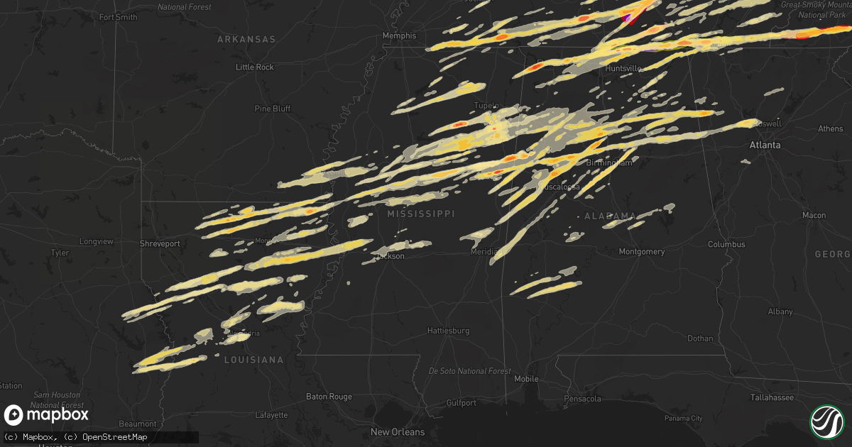
Hail Map in Mississippi on March 2, 2012
Get this storm
March 2 map
$229
one time, instant access
Download today. No call, no setup
Keep the $229
Bought the map and want the full workflow? Apply the entire $229 to a subscription within 7 days. None of it is wasted.
Every map, not just this one
This buys you this map. Subscription and you get every map we run, in the markets you choose from a few cities to whole states to nationwide. Plus real-time alerts the moment a storm fires.
Contact data
Name, contact info, occupancy, even credit band for addresses in the footprint. You go from where it hit to who to call.
Become the source they trust
Unlimited branding weather history reports on demand. You already have the documented answer ready for the property owner, and you are the one who showed up with it.
Property data and RoofTrace estimates
Pull up any address you have got, its value and the exact code rules for that jurisdiction, straight from One Click Code. Then RoofTrace estimates the squares, pitch, and roof value, priced the way you price.
Storm reports in Mississippi
Mississippi
| Date | Description |
|---|---|
| 03/02/20125:49 PM CST | Possible tornado damage. Structual damage at intersection of egypt and whiterock roads. |
| 03/02/20125:47 PM CST | Possible tornado. |
| 03/02/20125:45 PM CST | Tornado appeared on front edge of bow apex as it crossed highway 45. |
| 03/02/20125:40 PM CST | Several trees down in southern chikasaw county. |
| 03/02/20125:31 PM CST | A local report indicates 1.00 inch wind near WINONA |
| 03/02/20125:31 PM CST | 1 inch hail |
| 03/02/20125:30 PM CST | Estimated 70 mph wind. |
| 03/02/20125:30 PM CST | Trees on cars and cars blown off road in chickasaw county. Report relayed from nws jackson. |
| 03/02/20125:30 PM CST | Roof blown off baptist church and structural damage to a home on 4th st in the sand hill area. |
| 03/02/20125:30 PM CST | Numerous trees down and awnings on trailors ripped off. |
| 03/02/20125:30 PM CST | Trees on cars and cars blown off road in chickasaw county. Report relayed from nws jackson. |
| 03/02/20125:30 PM CST | Numerous trees down across belzoni. Tractor trailer blown off of highway 49. |
| 03/02/20125:30 PM CST | Trees on cars and cars blown off road in chickasaw county. Report relayed from nws jackson. |
| 03/02/20125:30 PM CST | Car blown off of highway 49. Another car had the front windshield busted out by large hail. |
| 03/02/20125:28 PM CST | Quarter to golf ball sized hail |
| 03/02/20125:25 PM CST | A roof was blown off a shed |
| 03/02/20125:23 PM CST | Trees down in the mantee and montevista communities |
| 03/02/20125:20 PM CST | Roofs off a trailer homes along with trees and power lines down in city limits. |
| 03/02/20125:15 PM CST | Ping pong sized hail in new albany along highway 30. |
| 03/02/20125:05 PM CST | Steeple and a few shingles blown off the roof of a church and a few trees down in ingomar. Report off a local media website. |
| 03/02/20125:01 PM CST | Quarter sized hail along us highway 49e at the leflore/holmes county line |
| 03/02/20124:45 PM CST | 1 inch hail at hwy 8 and 9 intersection. |
| 03/02/20124:41 PM CST | Powerlines down |
| 03/02/20124:34 PM CST | From local tv media website. Size estimated from picture. |
| 03/02/20124:15 PM CST | Quarter sized hail reported along highway 82 two miles west of carrollton. |
| 03/02/20124:10 PM CST | Several trees down |
| 03/02/20124:02 PM CST | Quarter size hail south of grenada |
| 03/02/20123:50 PM CST | Several power poles and medium to large trees blown down |
| 03/02/20123:48 PM CST | 7 power poles down...4 along highway 49w and 3 along highway 3 |
| 03/02/20123:45 PM CST | Three power poles blown down |
| 03/02/20123:41 PM CST | One inch hail. |
| 03/02/20123:35 PM CST | A local report indicates 1.25 inch wind near AMORY |
| 03/02/20123:25 PM CST | Report from local tv media website. Size estimated from picture. Hail could have been large when it fell. |
| 03/02/20123:18 PM CST | A local report indicates 2.00 inch wind near WREN |
| 03/02/20123:07 PM CST | A local report indicates 1.00 inch wind near NEW HOPE |
| 03/02/20123:02 PM CST | Couple of trees down across nashville ferry and old yorkville roads |
| 03/02/20122:48 PM CST | Tennis ball to baseball sized hail |
| 03/02/20122:45 PM CST | A local report indicates 1.75 inch wind near 3 N CRAWFORD |
| 03/02/20122:43 PM CST | A local report indicates 1.00 inch wind near WINTERVILLE |
| 03/02/20121:38 PM CST | A local report indicates 1.00 inch wind near 4 N MARIETTA |
| 03/01/201211:47 PM CST | Tornado rated ef0 with max winds of 85 mph...path width of 50 yards and was 1/4 mile long. The tornado began at 1147 pm 4 miles nne of carson and ended 4 miles nne of c |
| 03/01/201211:41 PM CST | Tornado rated ef0 with max winds of 85 mph...path width of 50 yards and was 1/4 mile long. The tornado began at 1141 pm 4 miles nne of carson and ended 4 miles nne of c |
| 03/01/201210:15 PM CST | A local report indicates 1.00 inch wind near MARTIN |
| 03/01/20128:40 PM CST | Numerous large limbs down in area along rice road...additionally...two trees were blown down in northbay subdivision...one on a house |
| 03/01/20128:11 PM CST | A local report indicates 3.00 inch wind near 5 W HOULKA |
| 03/01/20128:05 PM CST | A local report indicates 2.75 inch wind near STEENS |
| 03/01/20127:45 PM CST | Covered the ground |
| 03/01/20127:35 PM CST | A local report indicates 1.75 inch wind near 6 NNE BIGBEE VALLEY |
| 03/01/20127:35 PM CST | Several reports around the city. Reported by msu meteorology |
| 03/01/20127:34 PM CST | Reported by msu meteorology |
| 03/01/20127:33 PM CST | Reported by off duty natchez trace parkway officer |
| 03/01/20127:10 PM CST | Power lines downed in the 4000 block of oak ridge rd |
| 03/01/20127:05 PM CST | In the bywy community. |
| 03/01/20127:00 PM CST | A tree was downed along washington st...causing an car accident |
| 03/01/20127:00 PM CST | A local report indicates 1.00 inch wind near 4 NW ACKERMAN |
| 03/01/20127:00 PM CST | Trees down across us highway 11...white chapel...harold tucker roads...and interstate 59 near the forrest/lamar county line...possible tornado. One unconfirmed injury d |
| 03/01/20126:55 PM CST | A local report indicates 1.75 inch wind near 2 N FRENCH CAMP |
| 03/01/20126:40 PM CST | Spotters reported estimated wind gusts of 60 to 70 mph in poplar creek and lodi. At least one tree reported down. |
| 03/01/20126:38 PM CST | In causeyville community |
| 03/01/20126:28 PM CST | A local report indicates 1.00 inch wind near VAIDEN |
| 03/01/20126:23 PM CST | Tornado rated ef1 with max winds 100 mph and path width of 300 yds...began at 623 pm 5 ene of baxterville and tracked 12 miles to 6 s of hattiesburg at 645 pm...at leas |
| 03/01/20126:12 PM CST | From local tv media website. Size estimated from picture. |
| 03/01/20126:12 PM CST | Emergency managers reporting path of damage from near the town of baxterville to the north side of purvis to near the dixie community south of hattiesburg. At least two |
| 03/01/20126:08 PM CST | Quarter sized hail covering the ground |
All States Impacted by Hail Map on March 2, 2012
Cities Impacted by Hail Map on March 2, 2012
- Starkville, MS
- Oakdale, IL
- Coulterville, IL
- Salyersville, KY
- West Liberty, KY
- Cannel City, KY
- Saint Charles, MO
- Bowling Green, KY
- Rockfield, KY
- Amory, MS
- Aberdeen, MS
- Okolona, MS
- Fyffe, AL
- Geraldine, AL
- Sewanee, TN
- Winchester, TN
- Johnsonville, IL
- Iuka, IL
- Ladoga, IN
- Roachdale, IN
- Morris, AL
- Pinson, AL
- Ashville, AL
- Jacksonville, AL
- Ohatchee, AL
- Wellington, AL
- Holcomb, MS
- Unionville, TN
- Readyville, TN
- Lewisburg, TN
- Rockvale, TN
- Murfreesboro, TN
- Bradyville, TN
- Beechgrove, TN
- Bell Buckle, TN
- Christiana, TN
- Woodbury, TN
- Mcminnville, TN
- Chapel Hill, TN
- Anguilla, MS
- Richmond, IN
- Keyesport, IL
- Smithboro, IL
- Greenville, IL
- Mason, IL
- Watson, IL
- Effingham, IL
- Altamont, IL
- Brownstown, IL
- Saint Elmo, IL
- Pelahatchie, MS
- Brandon, MS
- Morton, MS
- Ethridge, TN
- Saint Anthony, IN
- Huntingburg, IN
- Birdseye, IN
- Dubois, IN
- Jasper, IN
- Celestine, IN
- Mount Vernon, IN
- Sandy Hook, KY
- Isonville, KY
- Gallipolis, OH
- Thurman, OH
- Patriot, OH
- Gallipolis Ferry, WV
- Henderson, WV
- Bidwell, OH
- Oak Hill, OH
- Point Pleasant, WV
- Cedarbluff, MS
- Pheba, MS
- Gate City, VA
- Weber City, VA
- Hiltons, VA
- Staunton, IL
- Gillespie, IL
- Wilsonville, IL
- Benld, IL
- Bunker Hill, IL
- Sawyerville, IL
- Mount Olive, IL
- Newcomb, TN
- Jellico, TN
- Williamsburg, KY
- Tupelo, MS
- Mooreville, MS
- Thomasville, AL
- Pine Hill, AL
- Camden, AL
- Coy, AL
- Coffeeville, AL
- Grove Hill, AL
- Lower Peach Tree, AL
- Scottsville, KY
- Pitkin, LA
- Richmond, KY
- Stanton, KY
- Winchester, KY
- Frenchburg, KY
- Means, KY
- Jeffersonville, KY
- Clay City, KY
- Pontotoc, MS
- Murphysboro, IL
- Waverly, TN
- Carthage, TN
- White Bluff, TN
- Elmwood, TN
- Kingston Springs, TN
- Holladay, TN
- Hermitage, TN
- Nashville, TN
- New Johnsonville, TN
- Burns, TN
- Mount Juliet, TN
- Lebanon, TN
- Pegram, TN
- Dickson, TN
- McEwen, TN
- Camden, TN
- Watertown, TN
- Fairview, TN
- Gordonsville, TN
- Hurricane Mills, TN
- Baskin, LA
- Delhi, LA
- Millstadt, IL
- Columbia, IL
- Belleville, IL
- Dupo, IL
- East Carondelet, IL
- Lawrenceburg, TN
- Savannah, TN
- Loretto, TN
- Westpoint, TN
- Leoma, TN
- Pulaski, TN
- Collinwood, TN
- Lutts, TN
- Iron City, TN
- Waterloo, AL
- Cypress Inn, TN
- Bessemer, AL
- New Ross, IN
- Advance, IN
- Russellville, IN
- Jamestown, IN
- Cohutta, GA
- Crandall, GA
- Dalton, GA
- New Market, AL
- Ardmore, TN
- Taft, TN
- Fayetteville, TN
- Ardmore, AL
- Kelso, TN
- Hazel Green, AL
- Athens, AL
- Elkmont, AL
- Toney, AL
- Enid, MS
- Pope, MS
- Etta, MS
- Guntown, MS
- Batesville, MS
- New Albany, MS
- Oxford, MS
- Blue Springs, MS
- Thaxton, MS
- Water Valley, MS
- Courtland, MS
- Baldwyn, MS
- Taylor, MS
- Myrtle, MS
- Georgetown, OH
- Poseyville, IN
- Manchester, TN
- Beech Bluff, TN
- Jackson, TN
- Medon, TN
- Grantsburg, IN
- English, IN
- Hartselle, AL
- Danville, AL
- Oliver Springs, TN
- Cub Run, KY
- Mammoth Cave, KY
- Flintstone, GA
- Rossville, GA
- Gattman, MS
- Detroit, AL
- Sulligent, AL
- Greenwood Springs, MS
- Fayette, AL
- Vernon, AL
- Kennedy, AL
- Elizabethtown, IN
- Westport, IN
- Greensburg, IN
- Hartsville, IN
- Columbus, IN
- Bedford, KY
- Hanover, IN
- Nabb, IN
- Scottsburg, IN
- Milton, KY
- Lexington, IN
- Houston, OH
- Piqua, OH
- Covington, OH
- Clay City, IL
- Dix, IL
- Kell, IL
- Texico, IL
- Centre, AL
- Lewisburg, KY
- Dunmor, KY
- Belton, KY
- Greenville, KY
- Elkton, KY
- Estill Springs, TN
- Lascassas, TN
- Mooreland, IN
- New Castle, IN
- Losantville, IN
- Killen, AL
- Florence, AL
- Cherokee, AL
- Warren, IN
- Grant, AL
- Hillsboro, IL
- Livingston, IL
- Moro, IL
- South Roxana, IL
- Beecher City, IL
- Roxana, IL
- East Alton, IL
- Wood River, IL
- Saint Louis, MO
- West Alton, MO
- Hamel, IL
- Fillmore, IL
- Florissant, MO
- Cowden, IL
- Edwardsville, IL
- Granite City, IL
- Cottage Hills, IL
- Worden, IL
- Ramsey, IL
- Coffeen, IL
- Bingham, IL
- Sorento, IL
- Bethalto, IL
- Hartford, IL
- Alton, IL
- Herrick, IL
- Godfrey, IL
- Alhambra, IL
- Dorsey, IL
- New Douglas, IL
- Donnellson, IL
- Toxey, AL
- Campbell, AL
- Dixons Mills, AL
- Silas, AL
- Arlington, AL
- Gilbertown, AL
- Glasgow, KY
- Cromwell, KY
- Horse Branch, KY
- Beaver Dam, KY
- Leitchfield, KY
- Caneyville, KY
- Millwood, KY
- Sweet Water, AL
- Bastrop, LA
- Tuckasegee, NC
- Franklin, NC
- Sylva, NC
- Glenville, NC
- Cullowhee, NC
- Dixon, KY
- Clay, KY
- Winnsboro, LA
- Mangham, LA
- Waverly, KY
- Crawford, MS
- Columbus, MS
- Joelton, TN
- Ashland City, TN
- Farmerville, LA
- Simsboro, LA
- Ruston, LA
- Sterlington, LA
- Choudrant, LA
- Gibsland, LA
- Arcadia, LA
- Marion, LA
- Dubach, LA
- Downsville, LA
- Louisa, KY
- Morehead, KY
- Wayne, WV
- Fort Gay, WV
- Grayson, KY
- Webbville, KY
- Clearfield, KY
- Catlettsburg, KY
- Olive Hill, KY
- Prichard, WV
- Salt Lick, KY
- Coalmont, TN
- Beersheba Springs, TN
- Palmer, TN
- Dunlap, TN
- Gruetli Laager, TN
- Pikeville, TN
- Altamont, TN
- Rogersville, AL
- Muscle Shoals, AL
- Gipsy, MO
- Greenville, MO
- Lowndes, MO
- Marble Hill, MO
- Zalma, MO
- Evansville, IN
- Kennesaw, GA
- Acworth, GA
- London, KY
- East Bernstadt, KY
- Hamlin, WV
- Myra, WV
- Branchland, WV
- Hulen, KY
- Evarts, KY
- Pineville, KY
- Wallins Creek, KY
- Ages Brookside, KY
- Kenvir, KY
- Miracle, KY
- Coalgood, KY
- Cawood, KY
- Grays Knob, KY
- Mary Alice, KY
- Pathfork, KY
- Middlesboro, KY
- Harlan, KY
- Gulston, KY
- Duck Hill, MS
- Hamilton, AL
- Woodland, MS
- Mantee, MS
- Beaverton, AL
- Hamilton, MS
- Gore Springs, MS
- Nettleton, MS
- Vardaman, MS
- Eupora, MS
- Maben, MS
- Prairie, MS
- Smithville, MS
- Calhoun City, MS
- Stewart, MS
- West Point, MS
- Bellefontaine, MS
- Houston, MS
- Lebanon Junction, KY
- Shepherdsville, KY
- Westfield, IL
- Toledo, IL
- Kansas, IL
- Charleston, IL
- Casey, IL
- Ashmore, IL
- Lerna, IL
- Trilla, IL
- Quitman, LA
- Bienville, LA
- Trussville, AL
- Springville, AL
- Shannon, MS
- New Liberty, KY
- Jonesville, KY
- Dry Ridge, KY
- Sanders, KY
- Sparta, KY
- Glencoe, KY
- Williamsport, KY
- Thelma, KY
- Beattyville, KY
- West Van Lear, KY
- Rogers, KY
- Oil Springs, KY
- Mize, KY
- Tomahawk, KY
- Meally, KY
- Hazel Green, KY
- Paintsville, KY
- Tutor Key, KY
- Staffordsville, KY
- Boons Camp, KY
- Campton, KY
- Slade, KY
- Hagerhill, KY
- Pine Ridge, KY
- Philadelphia, TN
- Niota, TN
- Soddy Daisy, TN
- Decatur, TN
- Sale Creek, TN
- Ten Mile, TN
- Athens, TN
- Sweetwater, TN
- Greenback, TN
- Evensville, TN
- Vonore, TN
- Loudon, TN
- Graysville, TN
- Dayton, TN
- Madisonville, TN
- Berry, AL
- Oakman, AL
- Parrish, AL
- Mount Sterling, KY
- Paris, KY
- Winfield, TN
- Oneida, TN
- Marshall, IN
- Rockville, IN
- Chattanooga, TN
- Pleasant Hill, LA
- Coushatta, LA
- Jonesboro, LA
- Winnfield, LA
- Goldonna, LA
- Robeline, LA
- Pelican, LA
- Dodson, LA
- Campti, LA
- Saline, LA
- Michie, TN
- Shiloh, TN
- Ramer, TN
- Selmer, TN
- Guys, TN
- Stantonville, TN
- Scottsboro, AL
- Birmingham, AL
- Dallas, GA
- Edmonton, KY
- Lynnville, TN
- Summertown, TN
- Jasper, TX
- Wiergate, TX
- Newton, TX
- Burkeville, TX
- Rockport, IN
- Olla, LA
- Mississippi State, MS
- Sharpsburg, KY
- Carlisle, KY
- Gardendale, AL
- Murphy, NC
- Prospect, TN
- Gurley, AL
- Middleton, TN
- Hillsboro, TN
- Ocoee, TN
- Meridianville, AL
- Ringgold, GA
- Holly Springs, MS
- Andrews, NC
- Topton, NC
- Harriman, TN
- McDonald, TN
- Decherd, TN
- Harvest, AL
- Sherwood, TN
- Frankewing, TN
- Normandy, TN
- Tuscumbia, AL
- Sardis, TN
- Leighton, AL
- Hollywood, AL
- Cleveland, TN
- Rockwood, TN
- Shelbyville, TN
- Fort Oglethorpe, GA
- Fackler, AL
- Culleoka, TN
- Morris Chapel, TN
- Saltillo, TN
- Saulsbury, TN
- Adamsville, TN
- Iuka, MS
- Tishomingo, MS
- Counce, TN
- Moscow, TN
- Bryant, AL
- Whitwell, TN
- Sequatchie, TN
- Belfast, TN
- Wildwood, GA
- Marble, NC
- Crump, TN
- Hixson, TN
- Grand Junction, TN
- Harrison, TN
- Farner, TN
- Petersburg, TN
- Benton, TN
- Dennis, MS
- Madison, AL
- Huntland, TN
- Reliance, TN
- Waynesboro, TN
- Stevenson, AL
- Rossville, TN
- Elora, TN
- Byhalia, MS
- Spring City, TN
- Cowan, TN
- Bethel Springs, TN
- Red Banks, MS
- Flat Rock, AL
- Turtletown, TN
- Copperhill, TN
- Courtland, AL
- Old Fort, TN
- Morrison, TN
- Ooltewah, TN
- Whiteside, TN
- Lookout Mountain, GA
- Jasper, TN
- Belvidere, TN
- South Pittsburg, TN
- Cornersville, TN
- Flintville, TN
- Hornsby, TN
- Woodville, AL
- Estillfork, AL
- Trenton, GA
- Town Creek, AL
- Grandview, TN
- Huntsville, AL
- Wartrace, TN
- Pocahontas, TN
- Signal Mountain, TN
- Lamar, MS
- Dellrose, TN
- Pelham, TN
- La Grange, TN
- Spencer, TN
- Sheffield, AL
- Monteagle, TN
- Bridgeport, AL
- Olivehill, TN
- Rock Island, TN
- Lester, AL
- Mulberry, TN
- Hayesville, NC
- Hillsboro, AL
- Guild, TN
- Crossville, TN
- Tracy City, TN
- Apison, TN
- Lookout Mountain, TN
- Paint Rock, AL
- Tanner, AL
- Russellville, AL
- Foster, KY
- Greenville, MS
- Lake Village, AR
- Mount Eden, KY
- Walnut Hill, IL
- Odin, IL
- Nashville, IL
- Centralia, IL
- Salem, IL
- Addieville, IL
- Hoyleton, IL
- Shelbyville, KY
- Owensboro, KY
- Morganfield, KY
- Calhoun, KY
- Sebree, KY
- Nebo, KY
- Pittsboro, MS
- Houlka, MS
- Durant, MS
- Vaiden, MS
- Mathiston, MS
- Hollandale, MS
- Millport, AL
- Silver City, MS
- Louise, MS
- Tchula, MS
- Ackerman, MS
- Kilmichael, MS
- Lexington, MS
- West, MS
- Coila, MS
- Ethel, MS
- Steens, MS
- Weir, MS
- French Camp, MS
- Cruger, MS
- Belzoni, MS
- Sturgis, MS
- Fulton, MO
- Science Hill, KY
- Somerset, KY
- Guntersville, AL
- Stonington, IL
- Taylorville, IL
- Palmer, IL
- Morrisonville, IL
- North Salem, IN
- Salem, IN
- Pekin, IN
- Sharon Grove, KY
- Indianola, MS
- Crossett, AR
- Portland, AR
- Doddsville, MS
- Moorhead, MS
- Hamburg, AR
- Dermott, AR
- Leland, MS
- Montrose, AR
- Inverness, MS
- Shaw, MS
- Itta Bena, MS
- Uniontown, KY
- Henderson, KY
- Corydon, KY
- Oak Grove, LA
- Sturgis, KY
- Utica, KY
- Farina, IL
- Shoals, IN
- Columbia, LA
- Olney, IL
- Noble, IL
- Carmi, IL
- Indianapolis, IN
- Avon, IN
- Carmel, IN
- Center, TX
- Leesville, LA
- Anacoco, LA
- Evans, LA
- Campbellsburg, IN
- Pana, IL
- Tower Hill, IL
- Vanceburg, KY
- Stout, OH
- Jena, LA
- Jonesville, LA
- Grayson, LA
- Rayville, LA
- Monroe, LA
- Chatham, LA
- Vicksburg, MS
- Redwood, MS
- Bolton, MS
- Tallulah, LA
- Bentonia, MS
- Sikes, LA
- Columbia, KY
- Alexander City, AL
- Jamestown, TN
- Borden, IN
- Yazoo City, MS
- Rolling Fork, MS
- Morgantown, KY
- La Fontaine, IN
- Converse, IN
- Amboy, IN
- Celina, TN
- Tompkinsville, KY
- Burkesville, KY
- Paris, IL
- Owingsville, KY
- Greenwood, IN
- Holton, IN
- North Vernon, IN
- Butlerville, IN
- Scipio, IN
- Gays, IL
- Windsor, IL
- Woodstock, AL
- West Blocton, AL
- Bethel, OH
- New Richmond, OH
- Moscow, OH
- California, KY
- Alexandria, KY
- Gravel Switch, KY
- Parksville, KY
- Bradfordsville, KY
- Lebanon, KY
- Homer, LA
- Bernice, LA
- Marion, IN
- Waterford, MS
- Potts Camp, MS
- Nancy, KY
- Hartsville, TN
- Castalian Springs, TN
- Bethpage, TN
- Whitleyville, TN
- Moss, TN
- Gallatin, TN
- Gamaliel, KY
- Dixon Springs, TN
- Lafayette, TN
- Red Boiling Springs, TN
- Greenup, IL
- Mattoon, IL
- Martinsville, IL
- Neoga, IL
- Winchester, OH
- Michigan City, MS
- Ashland, MS
- Mount Washington, KY
- Bardstown, KY
- Deatsville, AL
- Titus, AL
- Marbury, AL
- Holly Pond, AL
- New Hope, KY
- Loretto, KY
- New Haven, KY
- Ekron, KY
- Brandenburg, KY
- Guston, KY
- Irvington, KY
- South Shore, KY
- Pedro, OH
- Greenup, KY
- Franklin Furnace, OH
- Wheelersburg, OH
- South Webster, OH
- New Harmony, IN
- Crossville, IL
- Genoa, WV
- Wellington, KY
- East Lynn, WV
- Waco, KY
- Ezel, KY
- Dunlow, WV
- Elkfork, KY
- Adams, KY
- Martha, KY
- Blaine, KY
- Breese, IL
- Trenton, IL
- Aviston, IL
- Carlyle, IL
- Tunnel Hill, GA
- Hillsdale, IN
- Dana, IN
- Chrisman, IL
- Taylorsville, KY
- Knightsville, IN
- Staunton, IN
- Brazil, IN
- Buchanan, GA
- Cedartown, GA
- Whiteville, TN
- Bolivar, TN
- Somerville, TN
- Dawson, AL
- Warsaw, KY
- Florence, IN
- Patriot, IN
- Rising Sun, IN
- Vevay, IN
- Ghent, KY
- Owenton, KY
- Carrollton, KY
- Turners Station, KY
- Worthville, KY
- Campbellsburg, KY
- West Newton, IN
- Camby, IN
- Burnside, KY
- Bronston, KY
- Martinsville, IN
- Bentley, LA
- Pollock, LA
- Booneville, KY
- Lebanon, IN
- Rineyville, KY
- Ellsinore, MO
- Bainbridge, IN
- Greencastle, IN
- Yawkey, WV
- Sod, WV
- Sumerco, WV
- Norris City, IL
- Enfield, IL
- Hagerstown, IN
- Madison, IN
- Joaquin, TX
- Nacogdoches, TX
- Zwolle, LA
- Chireno, TX
- San Augustine, TX
- Marthaville, LA
- Noble, LA
- Atlanta, LA
- Natchitoches, LA
- Converse, LA
- Belmont, LA
- Shelbyville, TX
- Campbellsville, KY
- Raywick, KY
- Magnolia, KY
- Buffalo, KY
- Mount Sherman, KY
- Wildersville, TN
- Coldiron, KY
- Dayhoit, KY
- Baxter, KY
- Bledsoe, KY
- Putney, KY
- Clayton, IN
- Knoxville, TN
- Irvine, KY
- Crab Orchard, KY
- Danville, KY
- Lancaster, KY
- Berea, KY
- Paint Lick, KY
- Stanford, KY
- Carthage, IN
- Knightstown, IN
- Patoka, IN
- Deputy, IN
- Highland, IL
- Advance, NC
- Mocksville, NC
- Columbia, TN
- Terre Haute, IN
- Owens Cross Roads, AL
- Abbeville, MS
- Decatur, IL
- Friedheim, MO
- Fredericktown, MO
- Sedgewickville, MO
- Perryville, MO
- Marquand, MO
- Farrar, MO
- Patton, MO
- Frohna, MO
- Hardyville, KY
- Munfordville, KY
- Roundhill, KY
- Bonnieville, KY
- Horse Cave, KY
- Canmer, KY
- Brownsville, KY
- Aliceville, AL
- Carrollton, AL
- Macon, MS
- Maryville, TN
- Montgomery City, MO
- Junction, IL
- Kermit, WV
- Breeden, WV
- Winfield, AL
- Guin, AL
- Hardinsburg, KY
- Webster, KY
- Cannelton, IN
- Rome, IN
- Lewisport, KY
- Payneville, KY
- Stephensport, KY
- Hawesville, KY
- Union Star, KY
- Philpot, KY
- Maceo, KY
- Laconia, IN
- Helenwood, TN
- Duff, TN
- Frakes, KY
- Clairfield, TN
- Holmes Mill, KY
- Closplint, KY
- Hodgenville, KY
- Cookeville, TN
- Jonesboro, IN
- Swayzee, IN
- Cambridge City, IN
- Straughn, IN
- Greens Fork, IN
- Meridian, MS
- De Kalb, MS
- Daleville, MS
- Collinsville, MS
- Bailey, MS
- Cuba, AL
- Toomsuba, MS
- Mitchell, IN
- West Baden Springs, IN
- French Lick, IN
- Orleans, IN
- Strunk, KY
- Deridder, LA
- Merryville, LA
- Rosepine, LA
- Kirbyville, TX
- Centertown, KY
- Carrollton, MS
- Winona, MS
- Greenwood, MS
- Woodworth, LA
- Alexandria, LA
- Gainesboro, TN
- Granville, TN
- Chandler, IN
- Stilesville, IN
- Mooresville, IN
- Monrovia, IN
- Universal, IN
- Hidalgo, IL
- Fillmore, IN
- Rosedale, IN
- Harmony, IN
- Wheeler, IL
- Yale, IL
- Mecca, IN
- Centerpoint, IN
- Carbon, IN
- Amo, IN
- Cloverdale, IN
- Oblong, IL
- Willow Hill, IL
- Plainfield, IN
- Waveland, IN
- Riley, IN
- Reelsville, IN
- Greenfield, IN
- New Goshen, IN
- West York, IL
- Cory, IN
- Newton, IL
- Putnamville, IN
- Poland, IN
- West Union, IL
- Beech Grove, IN
- Marshall, IL
- Montezuma, IN
- Coatesville, IN
- Clinton, IN
- Annapolis, IL
- Crawfordsville, IN
- Dennison, IL
- West Terre Haute, IN
- Danville, IN
- Sondheimer, LA
- Epps, LA
- Pioneer, LA
- Lake Providence, LA
- Pleasureville, KY
- Lockport, KY
- Bethlehem, KY
- West Liberty, IL
- Dundas, IL
- Ethelsville, AL
- Marysville, IN
- Monterey, TN
- Clarkrange, TN
- Pennington Gap, VA
- Pioneer, TN
- La Follette, TN
- Cranks, KY
- Speedwell, TN
- Saint Charles, VA
- Goodman, MS
- Kosciusko, MS
- Pickens, MS
- McCool, MS
- Sallis, MS
- Benton, MS
- Moody, AL
- Odenville, AL
- Lexington, TN
- Westport, TN
- Old Hickory, TN
- Madison, TN
- Milam, TX
- Eckerty, IN
- Bristow, IN
- Nicholasville, KY
- Calhoun, LA
- West Monroe, LA
- Ridgeland, MS
- Jackson, MS
- Madison, MS
- White Hall, IL
- Clarksville, MO
- Annada, MO
- Hamburg, IL
- Kampsville, IL
- Elsberry, MO
- Eldred, IL
- Roodhouse, IL
- Silex, MO
- Hillview, IL
- Eolia, MO
- Nebo, IL
- Bellflower, MO
- Murrayville, IL
- Salem, KY
- Burnsville, NC
- Hot Springs, NC
- Hartford, TN
- Mars Hill, NC
- Del Rio, TN
- Marshall, NC
- Cosby, TN
- Jones, LA
- Bonita, LA
- Eudora, AR
- Princeton, IN
- Dunkirk, IN
- Muncie, IN
- Albany, IN
- McCalla, AL
- Trout, LA
- Sicily Island, LA
- Harrisonburg, LA
- Ferriday, LA
- Mayersville, MS
- Glen Allan, MS
- Mer Rouge, LA
- Mill Spring, MO
- Brownsburg, IN
- Pittsboro, IN
- Sandoval, IL
- Robards, KY
- Tazewell, TN
- Rose Hill, VA
- Jonesville, VA
- Ozark, IL
- Simpson, IL
- Vienna, IL
- Stonefort, IL
- Farragut, TN
- Lenoir City, TN
- Falmouth, IN
- Milton, IN
- Connersville, IN
- Central City, KY
- Clarkson, KY
- McHenry, KY
- Glendale, KY
- Sacramento, KY
- Madisonville, KY
- Island, KY
- Hartford, KY
- Falls Of Rough, KY
- Rosine, KY
- White Mills, KY
- Princeton, KY
- Fredonia, KY
- Dawson Springs, KY
- Sonora, KY
- Providence, KY
- Eastview, KY
- Manitou, KY
- Bremen, KY
- Big Clifty, KY
- Gracey, KY
- Crofton, KY
- Hardin, KY
- Cerulean, KY
- Cadiz, KY
- Hopkinsville, KY
- Benton, KY
- Cordova, AL
- Gadsden, AL
- Steele, AL
- Blountsville, AL
- Oneonta, AL
- Empire, AL
- Locust Fork, AL
- Leesburg, AL
- Jasper, AL
- Hayden, AL
- Rome, GA
- Cullman, AL
- Altoona, AL
- Collinsville, AL
- Hanceville, AL
- Bremen, AL
- Townley, AL
- Cleveland, AL
- Cave Spring, GA
- Attalla, AL
- Lindale, GA
- Boaz, AL
- Warrior, AL
- Quinton, AL
- Eddyville, IL
- Bryson City, NC
- Langston, AL
- Buena Vista, TN
- Huntingdon, TN
- Moorefield, KY
- Ewing, KY
- Flemingsburg, KY
- Gordo, AL
- Dora, AL
- Elrod, AL
- Mount Olive, AL
- Echola, AL
- Buhl, AL
- Graysville, AL
- Sumiton, AL
- Tuscaloosa, AL
- Coker, AL
- Northport, AL
- Tignall, GA
- Kelly, LA
- Tullos, LA
- Cleveland, NC
- Statesville, NC
- Vincent, KY
- Rushville, IN
- Cumberland Gap, TN
- Ewing, VA
- Harrogate, TN
- Belle Center, OH
- Huntsville, OH
- Bellefontaine, OH
- Walnut, MS
- Anna, IL
- Dongola, IL
- Buncombe, IL
- Nauvoo, AL
- Crane Hill, AL
- Arley, AL
- Double Springs, AL
- Marietta, GA
- Ashford, WV
- Alum Creek, WV
- Auburn, KY
- Russellville, KY
- Livingston, TN
- Mayfield, KY
- Brooksville, MS
- Gilbert, LA
- O'Fallon, MO
- Macedonia, IL
- McLeansboro, IL
- Willow Wood, OH
- Scottown, OH
- Kitts Hill, OH
- Bruce, MS
- Bear Creek, AL
- Big Creek, MS
- Coffeeville, MS
- Grenada, MS
- McCarley, MS
- Haleyville, AL
- Caledonia, MS
- Fulton, MS
- Plantersville, MS
- Tremont, MS
- Amherstdale, WV
- Bim, WV
- Clothier, WV
- Yolyn, WV
- Sullivan, IL
- Oconee, IL
- Findlay, IL
- Lakewood, IL
- Shelbyville, IL
- Eutaw, AL
- Spurlockville, WV
- Alkol, WV
- Denniston, KY
- Lowmansville, KY
- Keaton, KY
- Ranger, WV
- Midkiff, WV
- Julian, WV
- Griffithsville, WV
- Kiahsville, WV
- Peebles, OH
- West Union, OH
- Saint Meinrad, IN
- Ferdinand, IN
- Walland, TN
- Townsend, TN
- Tallassee, TN
- Goodlettsville, TN
- Smiths Grove, KY
- Park City, KY
- Cave City, KY
- Tell City, IN
- Robbins, TN
- Albertville, AL
- Groveoak, AL
- Amelia, OH
- Crown City, OH
- Glenwood, WV
- Lesage, WV
- Nokomis, IL
- Phil Campbell, AL
- Smithland, KY
- Brookport, IL
- Tiline, KY
- Grand Rivers, KY
- Paducah, KY
- Marion, KY
- Walling, TN
- Quebeck, TN
- Livingston, AL
- York, AL
- Powell, TN
- Clinton, TN
- Oak Ridge, TN
- Bridgeton, MO
- Saint Ann, MO
- Hazelwood, MO
- Earth City, MO
- Tennyson, IN
- Boonville, IN
- Kevil, KY
- Golconda, IL
- Karnak, IL
- Grand Chain, IL
- Metropolis, IL
- Olmsted, IL
- Hampton, KY
- Belknap, IL
- Grantsburg, IL
- La Center, KY
- Felicity, OH
- Francisco, IN
- Fort Branch, IN
- Owensville, IN
- Cynthiana, IN
- Oakland City, IN
- Haubstadt, IN
- Reform, AL
- Oakland, KY
- Alvaton, KY
- Mount Vernon, KY
- Russell Springs, KY
- Knob Lick, KY
- Liberty, KY
- Gradyville, KY
- Eubank, KY
- Franklin, KY
- Summer Shade, KY
- Woodburn, KY
- Adairville, KY
- Dunnville, KY
- Windsor, KY
- Centerville, IN
- Eldorado, OH
- Lewisville, IN
- Webster, IN
- Williamsburg, IN
- New Paris, OH
- West Manchester, OH
- Lynn, IN
- Economy, IN
- New Madison, OH
- Fountain City, IN
- Hazleton, IN
- Depauw, IN
- Palmyra, IN
- Eminence, KY
- Kingston, TN
- Mount Olivet, KY
- Mayslick, KY
- Uniontown, AL
- Marion, AL
- De Soto, IL
- Fort Payne, AL
- Cedar Bluff, AL
- Isola, MS
- Canton, MS
- Wisner, LA
- Xenia, IL
- Marble Hill, GA
- Ball Ground, GA
- Altenburg, MO
- Tullahoma, TN
- Spartanburg, SC
- Olympia, KY
- Lake Toxaway, NC
- Sapphire, NC
- Versailles, KY
- Coxs Creek, KY
- Waddy, KY
- Lawrenceburg, KY
- Frankfort, KY
- Brooks, KY
- Midway, KY
- Noblesville, IN
- Hardinsburg, IN
- Fredericksburg, IN
- Louisville, MS
- Heiskell, TN
- Eros, LA
- Inez, KY
- Zoe, KY
- Wilsondale, WV
- River, KY
- Junction City, KY
- Crum, WV
- Dingess, WV
- Beauty, KY
- Wittensville, KY
- Warfield, KY
- Ravenna, KY
- Debord, KY
- Sitka, KY
- Dow, IL
- Portage Des Sioux, MO
- Elsah, IL
- Grafton, IL
- Clanton, AL
- Maplesville, AL
- Whitesville, KY
- Witt, IL
- Ashley, IL
- Saint Peter, IL
- Kinmundy, IL
- Bloomington, IN
- Fenton, MO
- Arnold, MO
- Sieper, LA
- Seaman, OH
- Hillsboro, OH
- Benton, MO
- Charleston, MO
- Oran, MO
- Sikeston, MO
- Vanduser, MO
- Bell City, MO
- Scott City, MO
- Williamstown, KY
- Glens Fork, KY
- Wabash, IN
- Greentown, IN
- Kokomo, IN
- Apple Grove, WV
- Lexington, KY
- Georgetown, KY
- Southside, WV
- New Albany, IN
- Clarksville, IN
- Jeffersonville, IN
- Ironton, OH
- Summersville, KY
- Verona, KY
- Bennington, IN
- Union, KY
- Cedar Grove, TN
- Lavinia, TN
- Pinson, TN
- Griffin, IN
- Hermanville, MS
- West Lafayette, IN
- Alexandria, AL
- Raymond, MS
- Colfax, LA
- Boyce, LA
- Dry Prong, LA
- Lena, LA
- Fultondale, AL
- Union City, IN
- Austin, IN
- Panama, IL
- Jerseyville, IL
- Mulberry Grove, IL
- Glen Carbon, IL
- Marine, IL
- Otwell, IN
- Fraziers Bottom, WV
- Jonesboro, IL
- Harrisburg, IL
- Elizabethtown, IL
- Reed, KY
- Herod, IL
- Equality, IL
- Shawneetown, IL
- Carrier Mills, IL
- Goreville, IL
- Spottsville, KY
- Tamms, IL
- Russellville, OH
- Elmer, LA
- Pine Knot, KY
- Henderson, TN
- Elwood, IN
- Windfall, IN
- Richview, IL
- Okawville, IL
- Simpson, LA
- Slagle, LA
- Cecilia, KY
- Jewett, IL
- Union Grove, AL
- Brilliant, AL
- Fruithurst, AL
- Louisville, KY
- Crestwood, KY
- Pewee Valley, KY
- Camden, SC
- Westville, SC
- Chapmanville, WV
- Vancleve, KY
- Perryville, KY
- Lovely, KY
- Jackson, KY
- Greensburg, KY
- Upton, KY
- Hope, KY
- East Point, KY
- Harts, WV
- Kirksey, KY
- Hustonville, KY
- Van Lear, KY
- Jetson, KY
- South Charleston, WV
- Boligee, AL
- Suwanee, GA
- Alpharetta, GA
- Cumming, GA
- Ansonia, OH
- Union City, OH
- Kenna, WV
- Advent, WV
- Custer, KY
- Vine Grove, KY
- Bankston, AL
- Carbon Hill, AL
- Eldridge, AL
- McClure, IL
- Whitewater, MO
- Chaffee, MO
- Glenallen, MO
- Cape Girardeau, MO
- Advance, MO
- Williamsville, MO
- Wappapello, MO
- Troy, IL
- Summerfield, IL
- O'Fallon, IL
- Saint Jacob, IL
- Lebanon, IL
- Hackleburg, AL
- Battletown, KY
- Hineston, LA
- Huntsville, TN
- Sunbright, TN
- Caryville, TN
- Whiteland, IN
- Bargersville, IN
- Rockholds, KY
- Greenville, OH
- West Paducah, KY
- Wickliffe, KY
- Blue Mountain, MS
- Lambert, MS
- Ragland, AL
- Knoxville, AL
- Adger, AL
- Piedmont, AL
- Porterville, MS
- Emelle, AL
- Scooba, MS
- Tallapoosa, GA
- Saint Francis, KY
- Eddyville, KY
- Rumsey, KY
- Earlington, KY
- Graham, KY
- Olaton, KY
- Livermore, KY
- Burna, KY
- Rockport, KY
- Hanson, KY
- Elizabethtown, KY
- Springfield, KY
- Medina, TN
- Milan, TN
- Arcanum, OH
- Hollansburg, OH
- Morristown, IN
- Palestine, OH
- Spiceland, IN
- Modoc, IN
- Mays, IN
- Arlington, IN
- Lillie, LA
- Spearsville, LA
- Sawyerville, AL
- Akron, AL
- Huntington, IN
- Roanoke, IN
- Fishers, IN
- Westfield, IN
- Moundville, AL
- Spring Hill, TN
- Mount Pleasant, TN
- College Grove, TN
- Waterloo, OH
- Newbern, AL
- Maplewood, OH
- Milltown, IN
- Taswell, IN
- Marengo, IN
- Paoli, IN
- Englewood, TN
- Frankton, IN
- Danville, IL
- Covington, IN
- Edgewood, IL
- Alma, IL
- Patoka, IL
- Dieterich, IL
- Wadesville, IN
- Spurgeon, IN
- Velpen, IN
- Gentryville, IN
- Bethlehem, IN
- Leavenworth, IN
- Dale, IL
- Ramsey, IN
- Benton, IL
- Underwood, IN
- Royalton, IL
- West Frankfort, IL
- New Haven, IL
- Logan, IL
- Elberfeld, IN
- Carterville, IL
- New Salisbury, IN
- Carbondale, IL
- Sulphur, IN
- Dale, IN
- Winslow, IN
- Otisco, IN
- Thompsonville, IL
- Schnellville, IN
- Loogootee, IN
- Stendal, IN
- Henryville, IN
- Memphis, IN
- Pendleton, KY
- Gorham, IL
- Herrin, IL
- Sulphur, KY
- Orient, IL
- Freeman Spur, IL
- Lynnville, IN
- Hurst, IL
- Santa Claus, IN
- New Washington, IN
- Bedford, IN
- Zeigler, IL
- Mulkeytown, IL
- Walton, KY
- Saint Croix, IN
- Holland, IN
- Greenville, IN
- Broughton, IL
- Elkville, IL
- Flora, IL
- Strasburg, IL
- Stewardson, IL
- Fairdale, KY
- Sidon, MS
- Williamsburg, OH
- Galatia, IL
- Floyds Knobs, IN
- Canaan, IN
- Jacob, IL
- Ripley, OH
- Independence, KY
- Crandall, IN
- Eldorado, IL
- Sellersburg, IN
- Smithfield, KY
- Morning View, KY
- Lincoln City, IN
- Marion, IL
- Neville, OH
- Energy, IL
- Omaha, IL
- Mount Orab, OH
- Grayville, IL
- Corydon, IN
- Butler, KY
- Georgetown, IN
- Pittsburg, IL
- Chrisney, IN
- Buckner, KY
- Ava, IL
- Crittenden, KY
- Heltonville, IN
- Hamersville, OH
- Charlestown, IN
- Evanston, IN
- Leopold, IN
- Lamar, IN
- De Mossville, KY
- Sardinia, OH
- La Grange, KY
- Dover, KY
- Pomona, IL
- Falmouth, KY
- Johnston City, IL
- Branchville, IN
- New Castle, KY
- Elizabeth, IN
- Muldraugh, KY
- Fisherville, KY
- West Point, KY
- Fort Knox, KY
- Richland, IN
- Rhodelia, KY
- Clermont, KY
- Hillsboro, KY
- Athens, LA
- Minden, LA
- Wilmot, AR
- Van Buren, IN
- Lanesville, IN
- Lynn, AL
- Center, KY
- Pineville, LA
- Milton, WV
- Oak Ridge, LA
- Auburntown, TN
- Shumway, IL
- Sigel, IL
- Hudson, KY
- Fordsville, KY
- McDaniels, KY
- Westview, KY
- Sparta, TN
- Lizton, IN
- Carthage, TX
- Cloverport, KY
- Cypress, IL
- Stamping Ground, KY
- Rossburg, OH
- Thomaston, AL
- Catherine, AL
- Alberta, AL
- Blackwater, VA
- Pleasant Shade, TN
- Riddleton, TN
- Leeds, AL
- Anderson, IN
- Lapel, IN
- Benton Harbor, MI
- Saint Joseph, MI
- Jackson, MO
- Oak Ridge, MO
- Owaneco, IL
- Bon Aqua, TN
- Only, TN
- Brush Creek, TN
- Yuma, TN
- Rockmart, GA
- Rainbow City, AL
- Silver Creek, GA
- Horton, AL
- Woodruff, SC
- Greer, SC
- Brent, AL
- Finchville, KY
- Newburgh, IN
- Imperial, MO
- Tougaloo, MS
- Clinton, MS
- Goshen, KY
- Dutton, AL
- Section, AL
- Smithville, TN
- Cave In Rock, IL
- New Llano, LA
- Fort Polk, LA
- Woodville, TX
- Brookwood, AL
- Cottondale, AL
- White Plains, KY
- Boggstown, IN
- Needham, IN
- Fairland, IN
- Hendersonville, TN
- Hilham, TN
- Surgoinsville, TN
- Sparta, IL
- Baldwin, IL
- Evansville, IL
- Winchester, IN
- McKee, KY
- Sandgap, KY
- Kellyton, AL
- Equality, AL
- Rockford, AL
- Slaughters, KY
- Calhoun, TN
- Etowah, TN
- Tellico Plains, TN
- Riceville, TN
- Buffalo, WV
- Leon, WV
- Radcliff, KY
- Alabaster, AL
- Cottontown, TN
- White House, TN
- Daisy, MO
- Milton, TN
- Alexandria, TN
- Liberty, TN
- Linden, TN
- Clifton, TN
- Bath Springs, TN
- Roebuck, SC
- Plantersville, AL
- Loami, IL
- Vidalia, LA
- Teutopolis, IL
- Mozelle, KY
- Mauckport, IN
- Central, IN
- Rosiclare, IL
- Vance, AL
- Edwards, MS
- Utica, MS
- Hutsonville, IL
- Ledbetter, KY
- Prospect, KY
- Franklin, IL
- Kyles Ford, TN
- Duffield, VA
- Sneedville, TN
- Collinsville, IL
- Church Hill, TN
- Kingsport, TN
- Letart, WV
- Albany, KY
- Somerville, AL
- Decatur, AL
- Moore, SC
- Portland, TN
- Liberty, WV
- Ingraham, IL
- Marissa, IL
- Bluford, IL
- Walsh, IL
- Louisville, IL
- Sainte Genevieve, MO
- Rinard, IL
- Irvington, IL
- Woodlawn, IL
- Ellis Grove, IL
- Tilden, IL
- Modoc, IL
- Lenzburg, IL
- Ridge Farm, IL
- Flat Lick, KY
- Walker, KY
- Falkville, AL
- Montrose, IL
- Union, MS
- Little Rock, MS
- Warren, TX
- West Milton, OH
- Lewisburg, OH
- Laura, OH
- Markle, IN
- Bartelso, IL
- Emerson, KY
- Madison, WV
- Jeffrey, WV
- Franklin, IN
- Collinston, LA
- Transylvania, LA
- Fairview Heights, IL
- Lynchburg, TN
- Salvisa, KY
- Harrodsburg, KY
- Kingstree, SC
- Jamestown, KY
- Shelbyville, IN
- Fountaintown, IN
- Jacksons Gap, AL
- Fort Recovery, OH
- Portland, IN
- Gaylesville, AL
- Lyerly, GA
- Corinth, MS
- Yorktown, IN
- Gaston, IN
- Wallingford, KY
- Brierfield, AL
- Duncanville, AL
- Humboldt, TN
- Alcoa, TN
- Rockford, TN
- Louisville, TN
- Vandalia, IL
- Shobonier, IL
- Mode, IL
- Pocahontas, IL
- Stearns, KY
- Mount Alto, WV
- Cottageville, WV
- Palmetto, GA
- Chatham, MS
- Houston, AL
- Gallant, AL
- Remlap, AL
- Addison, AL
- Vinemont, AL
- Ralph, AL
- Woodstock, GA
- Taylorsville, GA
- Aragon, GA
- Adamsville, AL
- Logan, AL
- Powder Springs, GA
- Muscadine, AL
- Vina, AL
- Trenton, KY
- Olmstead, KY
- Allensville, KY
- Guthrie, KY
- Burnsville, MS
- Tebbetts, MO
- Harned, KY
- Silva, MO
- Garfield, KY
- Leopold, MO
- Thebes, IL
- Reynolds Station, KY
- Andrews, IN
- Billingsley, AL
- East Saint Louis, IL
- New Baden, IL
- Germantown, IL
- Zionsville, IN
- New Palestine, IN
- Whitestown, IN
- Vernon, IL
- Beckemeyer, IL
- Eaton, IN
- Hartford City, IN
- Cynthiana, KY
- Verbena, AL
- Cayuga, IN
- Stoney Fork, KY
- Beverly, KY
- Arjay, KY
- Williston, TN
- Springfield, TN
- Cedar Hill, TN
- Keokee, VA
- Benham, KY
- Allardt, TN
- Cumberland, KY
- Dryden, VA
- Rochester, KY
- Crossville, AL
- Eva, AL
- Elk Horn, KY
- Mackville, KY
- Portland, MO
- Steedman, MO
- Charlotte, TN
- Selma, AL
- Calvin, KY
- Chunky, MS
- Decatur, MS
- Pell City, AL
- Calhoun, IL
- Falkner, MS
- Anna, OH
- Sidney, OH
- Clemmons, NC
- Woodleaf, NC
- Buffalo Valley, TN
- Willisburg, KY
- Mount Carmel, TN
- Mendota, VA
- Bristol, VA
- Irving, IL
- Rosamond, IL
- Raymond, IL
- Butler, IL
- Brodhead, KY
- Lisbon, LA
- Summerfield, LA
- Arab, AL
- Sardis, MS
- Logan, WV
- Silver Point, TN
- Baxter, TN
- Bloomfield, KY
- Williams, IN
- Lena, MS
- Forest, MS
- Otis, LA
- Docena, AL
- Mulga, AL
- Duluth, GA
- Given, WV
- Clayton, LA
- Bradford, OH
- Hartsburg, MO
- Lucas, KY
- Aurora, IN
- Dillsboro, IN
- Tilton, IL
- Catlin, IL
- Westville, IL
- Dawsonville, GA
- Danville, WV
- New Hope, AL
- Marion Junction, AL
- Parkdale, AR
- New Market, IN
- Claremont, IL
- Sumner, IL
- Westmoreland, TN
- Jasper, GA
- Sadieville, KY
- Springport, IN
- Parker City, IN
- Selma, IN
- Montevallo, AL
- Ridgeville, IN
- Middletown, MO
- Thorsby, AL
- Warbranch, KY
- Charleston, TN
- Maysville, KY
- Fort Wayne, IN
- Fort Necessity, LA
- Georgetown, LA
- Hammond, IL
- Niantic, IL
- Mccordsville, IN
- Springerton, IL


