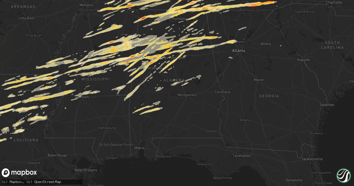
Hail Map in Alabama on March 2, 2012
Get this storm
March 2 map
$229
one time, instant access
Download today. No call, no setup
Keep the $229
Bought the map and want the full workflow? Apply the entire $229 to a subscription within 7 days. None of it is wasted.
Every map, not just this one
This buys you this map. Subscription and you get every map we run, in the markets you choose from a few cities to whole states to nationwide. Plus real-time alerts the moment a storm fires.
Contact data
Name, contact info, occupancy, even credit band for addresses in the footprint. You go from where it hit to who to call.
Become the source they trust
Unlimited branding weather history reports on demand. You already have the documented answer ready for the property owner, and you are the one who showed up with it.
Property data and RoofTrace estimates
Pull up any address you have got, its value and the exact code rules for that jurisdiction, straight from One Click Code. Then RoofTrace estimates the squares, pitch, and roof value, priced the way you price.
Storm reports in Alabama
Alabama
| Date | Description |
|---|---|
| 03/02/20125:52 PM CST | Dime to quarter size hail was reported. |
| 03/02/20125:49 PM CST | Quarter size hail was reported. |
| 03/02/20125:39 PM CST | Fire dept reported quarter size hail in springville. |
| 03/02/20125:36 PM CST | Roof off building on highway 266. |
| 03/02/20125:12 PM CST | Up to quarter size hail was reported. |
| 03/02/20125:01 PM CST | Several reports of a tornado received west of brooklyn. |
| 03/02/20124:58 PM CST | Quarter size hail was reported on bryant mountain. |
| 03/02/20124:53 PM CST | Two tornadoes reported in the town of opp about a mile apart. |
| 03/02/20124:50 PM CST | A local report indicates a tornado near OPP |
| 03/02/20124:50 PM CST | Quarter size hail was observed in dora. |
| 03/02/20124:49 PM CST | Depth upto an inch of quarter sized hail reported |
| 03/02/20124:45 PM CST | Dime to quarter size hail was reported. |
| 03/02/20124:40 PM CST | A local report indicates 1.50 inch wind near YELLOW BLUFF |
| 03/02/20124:39 PM CST | Clarke county emergency manager reported quarter size hail in cunningham. |
| 03/02/20124:37 PM CST | Quarter size hail near sipsey. |
| 03/02/20124:34 PM CST | A local report indicates 1.00 inch wind near 3 S HALEYVILLE |
| 03/02/20124:31 PM CST | Trees were blown down at sr 269 and 24th st. |
| 03/02/20124:31 PM CST | Quarter size hail at 1302 8th ave in jasper. |
| 03/02/20124:22 PM CST | Large hail up to the size of golf balls were observed along highway 69 along the walker...tuscaloosa county line. |
| 03/02/20124:18 PM CST | Quarter sized hail reported near austinville rd. |
| 03/02/20124:09 PM CST | Measured in the 1500 block of elkwood section road. |
| 03/02/20124:06 PM CST | Golfball size hail reported. |
| 03/02/20124:05 PM CST | Quarter sized hail reported at butler rd and new market rd |
| 03/02/20124:03 PM CST | Quarter to half dollar sized hail reported at joe quick rd and tanner rd |
| 03/02/20124:00 PM CST | Golfball size hail reported. |
| 03/02/20123:59 PM CST | Golfball size hail was reported. |
| 03/02/20123:58 PM CST | Hail of just over one inch reported just south of new lexington. |
| 03/02/20123:55 PM CST | A local report indicates 1.00 inch wind near DOUBLE SPRINGS |
| 03/02/20123:53 PM CST | Nws storm survey teams concluded that an ef1 tornado touched down just north of braggs in western lowndes county and travelled across the county impacting numerous comm |
| 03/02/20123:52 PM CST | Tree damage was reported. |
| 03/02/20123:49 PM CST | Trees down and structural damage to roof 3 miles north of rogersville. |
| 03/02/20123:48 PM CST | Golf ball sized hail reported at ready section rd and wall triana hwy |
| 03/02/20123:45 PM CST | Half dollar sized hail falling 4 miles nnw of hazel green |
| 03/02/20123:39 PM CST | An ef1 tornado with path length of 2.6 miles and max path width of 150 yards touched down just west of the intersection of thach road and oak grove road. It paralleled |
| 03/02/20123:26 PM CST | An ef-0 tornado touched down on the west side of edgewood road/cr 65 a little south of the intersection with coffman road. Several trees were uprooted in this area with |
| 03/02/20123:26 PM CST | An ef-0 tornado touched down on the west side of edgewood road/cr 65 a little south of the intersection with coffman road. Several trees were uprooted in this area with |
| 03/02/20123:21 PM CST | Trees were blown down on a house in white pike area. Fire and ems enroute to location. Injuries unknown. |
| 03/02/20123:15 PM CST | Several trees and powerlines were blown down. |
| 03/02/20123:05 PM CST | 2 inches of hail up to the size of quarters was reported. |
| 03/02/20123:00 PM CST | Quarter size hail was reported. |
| 03/02/20122:46 PM CST | Roof was blown off of a building at 2nd street and woodward. Possible tornado damage. |
| 03/02/20122:45 PM CST | Dime to quarter size hail was reported covering the ground. |
| 03/02/20122:35 PM CST | Half dollar sized hail reported in florence |
| 03/02/20122:35 PM CST | Quarter size hail was reported. |
| 03/02/20122:35 PM CST | Small tree limbs down north of florence |
| 03/02/20122:30 PM CST | Quarter size hail was reported. |
| 03/02/20122:18 PM CST | Golfball size hail was reported. |
| 03/02/20122:15 PM CST | Baseball sized hail reported in barton |
| 03/02/20122:07 PM CST | Quarter and nickel sized hail reported |
| 03/02/20122:02 PM CST | An ef-0 tornado first touched down in farm fields near the intersection of easter farm road and cr 49/morris road. Several tree limbs were snapped in this area along wi |
| 03/02/20122:00 PM CST | Quarter sized hail and possible wall cloud reported near i-65 welcome center. |
| 03/02/20121:55 PM CST | An ef-0 tornado first touched down in farm fields near the intersection of easter farm road and cr 49/morris road. Several tree limbs were snapped in this area along wi |
| 03/02/201210:54 AM CST | Power lines down on roads and damage to farm building |
| 03/02/201210:43 AM CST | Powerlines down at beth and butler roads |
| 03/02/201210:32 AM CST | Trees down...cars damaged and farm house destroyed near buckhorn high school |
| 03/02/201210:19 AM CST | House destroyed |
| 03/02/201210:19 AM CST | People trapped in rubble with injuries |
| 03/02/201210:15 AM CST | Tornado on ground |
| 03/02/201210:08 AM CST | Tornado on ground |
| 03/02/201210:07 AM CST | Rain wrap tornado |
| 03/02/201210:06 AM CST | An ef-2 tornado touched down just south of the madison county executive airport in meridianville and tracked east-northeast for 7.3 miles before lifting just east of bu |
| 03/02/201210:05 AM CST | A local report indicates 1.75 inch wind near MERIDIANVILLE |
| 03/02/201210:01 AM CST | Rain wrap tornado |
| 03/02/20129:58 AM CST | A local report indicates 1.75 inch wind near ARDMORE |
| 03/02/20129:56 AM CST | Rain wrapped tornado reported on the ground at nick david and jeff rd. |
| 03/02/20129:49 AM CST | Research park blvd and dan tibbs...funnel cloud |
| 03/02/20129:47 AM CST | Power lines down on car |
| 03/02/20129:43 AM CST | 50 mph winds with power lines sparking...rotation reported. Tornado reported on ground |
| 03/02/20129:20 AM CST | Power lines and trees down and structural damage seen at craft road and mooresville road. |
| 03/02/20129:20 AM CST | Wind picking up debris with estimated wind gust of 50mph. Rotation seen in storm. No injuries. |
| 03/02/20129:10 AM CST | A long track ef-3 tornado began in east central limestone county and tracked over 34 miles lifting in extreme northeast madison county. Maximum path width was 250 yards |
| 03/01/201211:50 PM CST | Several trees were blown down in piney wood |
| 03/01/201211:05 PM CST | Quarter size hail fell along cr 19. |
| 03/01/201211:04 PM CST | Tree blown down on a home along 5th ave. |
| 03/01/201210:58 PM CST | Trees and powerlines down across denver road for approximately one mile. Possible tornado. |
| 03/01/201210:51 PM CST | A local report indicates 63 MPH wind near 5 NE HOKES BLUFF |
| 03/01/201210:40 PM CST | Tree down on a car at dewey heights road and hickory trail in pinson. |
| 03/01/201210:40 PM CST | Trees down along hwy 411 in gadsden. |
| 03/01/201210:36 PM CST | Damage to at least 2 homes and numerous trees down in attalla. One business sustained damage to brick veneer. Two business signs blown out. |
| 03/01/201210:03 PM CST | Damage to homes along hwy 31 just south of verbena. Possible tornado. |
| 03/01/201210:01 PM CST | Tornado in southern chilton and southern coosa counties. At least a dozen homes were damaged or destroyed. Hundreds of trees were snapped or uprooted. Path was 28 miles |
| 03/01/20129:35 PM CST | Quarter size hail was reported. |
| 03/01/20129:31 PM CST | Multiple trees were blown down on al hwy 22 just south of plantersville. Possible tornado. |
| 03/01/20129:29 PM CST | Multiple trees and power lines were blown down at the state park. Possible tornado. |
| 03/01/20129:15 PM CST | Chicken house damaged with front corner and approximately 20 feet of roof blown off and wrapped around tree. |
| 03/01/20128:30 PM CST | A local report indicates 1.75 inch wind near 3 NNE MILLPORT |
| 03/01/20128:28 PM CST | A local report indicates 1.00 inch wind near 2 SSW FOWLERS CROSSROAD |
| 03/01/20128:25 PM CST | Golf ball size hail fell at markland rd and empire rd. |
| 03/01/20128:15 PM CST | Multiple cars damaged. |
| 03/01/20128:10 PM CST | Quarter size hail along with a couple of trees blown down. |
| 03/01/20128:07 PM CST | A local report indicates 1.75 inch wind near SAMANTHA |
| 03/01/20128:05 PM CST | Trees were blown down near the intersection of cr 2 and hwy 96. |
| 03/01/20127:50 PM CST | Quarter size hail was reported in winfield. |
| 03/01/20127:50 PM CST | Reported just south of shelton state community college. |
| 03/01/20127:40 PM CST | Quaretr size hail was reported near the north winds subdivision on old fayette rd. |
| 03/01/20127:35 PM CST | Golf ball size hail was reported near the intersection of rue rd and bone camp rd. |
| 03/01/20127:33 PM CST | Quarter size hail was observed in livingston. |
| 03/01/20127:33 PM CST | Quarter size hail fell in odenville. |
| 03/01/20127:33 PM CST | Quarter size hail fell at margaret. |
| 03/01/20127:29 PM CST | Golf ball size hail was reported at cr10 firehouse 2. |
| 03/01/20127:25 PM CST | Unknown damage reported at the hoover apartments at the uwa campus. |
| 03/01/20127:25 PM CST | Hoover apartnemts uwa campus |
| 03/01/20127:15 PM CST | Quarter size hail was observed near reece city. |
| 03/01/20127:14 PM CST | Half dollar size hail was observed at the ross bridge resort. |
| 03/01/20127:14 PM CST | A local report indicates 1.75 inch wind near BLUFF PARK |
| 03/01/20127:11 PM CST | Quarter size hail was observed in bluff park. |
| 03/01/20127:11 PM CST | Bluff park |
| 03/01/20127:10 PM CST | Dime to quarter sized hail fell for 5 to 10 minutes in scottsboro. |
| 03/01/20127:07 PM CST | Unknown damage reported at the hoover apartments at the uwa campus. Also trees down near the sumter county board of education in livingston. |
| 03/01/20127:03 PM CST | Golf ball size hail was reported in laceys chapel. |
| 03/01/20126:58 PM CST | Nickel to quarter size hail was reported. |
| 03/01/20126:57 PM CST | Two trees down in york. One tree was blocking highway 11 near hill hospital. |
| 03/01/20126:57 PM CST | Large hail was observed east northeast of jasper. |
| 03/01/20126:55 PM CST | A tin roof blown off of a shed near the intersection of cr 10 and hwy 11. Metal awning blown off of a mobile home near the intersection of hwy 11 and sheepskin rd. Roof |
| 03/01/20126:55 PM CST | National weather service meteorologists surveyed eastern cleburne county. Damage was consistent with strong inflow winds on the south side of the storm. Maximum winds w |
| 03/01/20126:55 PM CST | Several trees were blown down near piney wood and cr 14. |
| 03/01/20126:55 PM CST | Quarter size hail fell near double springs. |
| 03/01/20126:52 PM CST | Quarter size hail fell near mccalla. |
| 03/01/20126:50 PM CST | Quarter size hail fell near double springs. |
| 03/01/20126:49 PM CST | Quarter size hail was reported. |
| 03/01/20126:48 PM CST | Golf ball size hail was observed at the tannehill ironworks state park. |
| 03/01/20126:46 PM CST | Trees down on eastern valley rd near the tuscaloosa county line. Power outages also reported in the same area. |
| 03/01/20126:45 PM CST | Large hail was observed east northeast of jasper. |
| 03/01/20126:45 PM CST | Hail up to one inch in downtown jasper. |
| 03/01/20126:44 PM CST | A local report indicates 1.00 inch wind near 2 E WOODSTOCK JUNCTION |
| 03/01/20126:39 PM CST | Half dollar size hail fell in susan moore. |
| 03/01/20126:30 PM CST | Quarter size hail was observed in jacksonville. |
| 03/01/20126:30 PM CST | A local report indicates 1.25 inch wind near 5 SW BRIDGEPORT |
| 03/01/20126:27 PM CST | Quarter size hail was observed in blountsville. |
| 03/01/20126:25 PM CST | Quarter size hail was reported in wellington. |
| 03/01/20126:23 PM CST | Trees down on a residence near the intersection of cr 35 and georgia circle. |
| 03/01/20126:18 PM CST | Reported by instructor pilot out of fort rucker. |
| 03/01/20126:15 PM CST | Trees snapped and uprooted in detroit. People trapped in a storm shelter. |
| 03/01/20126:07 PM CST | Unconfirmed report of a tornado as person was driving along state highway 52 near hartford. The location of the tornado was estimated to be to the north of the town lim |
| 03/01/20126:06 PM CST | Significant tree damage was reported along state road 21 near the beechwood community. Possible tornado. |
| 03/01/20126:03 PM CST | Nws storm survey teams concluded that an ef1 tornado touched down just north of braggs in western lowndes county and travelled across the county impacting numerous comm |
All States Impacted by Hail Map on March 2, 2012
Cities Impacted by Hail Map on March 2, 2012
- Starkville, MS
- Oakdale, IL
- Coulterville, IL
- Salyersville, KY
- West Liberty, KY
- Cannel City, KY
- Saint Charles, MO
- Bowling Green, KY
- Rockfield, KY
- Amory, MS
- Aberdeen, MS
- Okolona, MS
- Fyffe, AL
- Geraldine, AL
- Sewanee, TN
- Winchester, TN
- Johnsonville, IL
- Iuka, IL
- Ladoga, IN
- Roachdale, IN
- Morris, AL
- Pinson, AL
- Ashville, AL
- Jacksonville, AL
- Ohatchee, AL
- Wellington, AL
- Holcomb, MS
- Unionville, TN
- Readyville, TN
- Lewisburg, TN
- Rockvale, TN
- Murfreesboro, TN
- Bradyville, TN
- Beechgrove, TN
- Bell Buckle, TN
- Christiana, TN
- Woodbury, TN
- Mcminnville, TN
- Chapel Hill, TN
- Anguilla, MS
- Richmond, IN
- Keyesport, IL
- Smithboro, IL
- Greenville, IL
- Mason, IL
- Watson, IL
- Effingham, IL
- Altamont, IL
- Brownstown, IL
- Saint Elmo, IL
- Pelahatchie, MS
- Brandon, MS
- Morton, MS
- Ethridge, TN
- Saint Anthony, IN
- Huntingburg, IN
- Birdseye, IN
- Dubois, IN
- Jasper, IN
- Celestine, IN
- Mount Vernon, IN
- Sandy Hook, KY
- Isonville, KY
- Gallipolis, OH
- Thurman, OH
- Patriot, OH
- Gallipolis Ferry, WV
- Henderson, WV
- Bidwell, OH
- Oak Hill, OH
- Point Pleasant, WV
- Cedarbluff, MS
- Pheba, MS
- Gate City, VA
- Weber City, VA
- Hiltons, VA
- Staunton, IL
- Gillespie, IL
- Wilsonville, IL
- Benld, IL
- Bunker Hill, IL
- Sawyerville, IL
- Mount Olive, IL
- Newcomb, TN
- Jellico, TN
- Williamsburg, KY
- Tupelo, MS
- Mooreville, MS
- Thomasville, AL
- Pine Hill, AL
- Camden, AL
- Coy, AL
- Coffeeville, AL
- Grove Hill, AL
- Lower Peach Tree, AL
- Scottsville, KY
- Pitkin, LA
- Richmond, KY
- Stanton, KY
- Winchester, KY
- Frenchburg, KY
- Means, KY
- Jeffersonville, KY
- Clay City, KY
- Pontotoc, MS
- Murphysboro, IL
- Waverly, TN
- Carthage, TN
- White Bluff, TN
- Elmwood, TN
- Kingston Springs, TN
- Holladay, TN
- Hermitage, TN
- Nashville, TN
- New Johnsonville, TN
- Burns, TN
- Mount Juliet, TN
- Lebanon, TN
- Pegram, TN
- Dickson, TN
- McEwen, TN
- Camden, TN
- Watertown, TN
- Fairview, TN
- Gordonsville, TN
- Hurricane Mills, TN
- Baskin, LA
- Delhi, LA
- Millstadt, IL
- Columbia, IL
- Belleville, IL
- Dupo, IL
- East Carondelet, IL
- Lawrenceburg, TN
- Savannah, TN
- Loretto, TN
- Westpoint, TN
- Leoma, TN
- Pulaski, TN
- Collinwood, TN
- Lutts, TN
- Iron City, TN
- Waterloo, AL
- Cypress Inn, TN
- Bessemer, AL
- New Ross, IN
- Advance, IN
- Russellville, IN
- Jamestown, IN
- Cohutta, GA
- Crandall, GA
- Dalton, GA
- New Market, AL
- Ardmore, TN
- Taft, TN
- Fayetteville, TN
- Ardmore, AL
- Kelso, TN
- Hazel Green, AL
- Athens, AL
- Elkmont, AL
- Toney, AL
- Enid, MS
- Pope, MS
- Etta, MS
- Guntown, MS
- Batesville, MS
- New Albany, MS
- Oxford, MS
- Blue Springs, MS
- Thaxton, MS
- Water Valley, MS
- Courtland, MS
- Baldwyn, MS
- Taylor, MS
- Myrtle, MS
- Georgetown, OH
- Poseyville, IN
- Manchester, TN
- Beech Bluff, TN
- Jackson, TN
- Medon, TN
- Grantsburg, IN
- English, IN
- Hartselle, AL
- Danville, AL
- Oliver Springs, TN
- Cub Run, KY
- Mammoth Cave, KY
- Flintstone, GA
- Rossville, GA
- Gattman, MS
- Detroit, AL
- Sulligent, AL
- Greenwood Springs, MS
- Fayette, AL
- Vernon, AL
- Kennedy, AL
- Elizabethtown, IN
- Westport, IN
- Greensburg, IN
- Hartsville, IN
- Columbus, IN
- Bedford, KY
- Hanover, IN
- Nabb, IN
- Scottsburg, IN
- Milton, KY
- Lexington, IN
- Houston, OH
- Piqua, OH
- Covington, OH
- Clay City, IL
- Dix, IL
- Kell, IL
- Texico, IL
- Centre, AL
- Lewisburg, KY
- Dunmor, KY
- Belton, KY
- Greenville, KY
- Elkton, KY
- Estill Springs, TN
- Lascassas, TN
- Mooreland, IN
- New Castle, IN
- Losantville, IN
- Killen, AL
- Florence, AL
- Cherokee, AL
- Warren, IN
- Grant, AL
- Hillsboro, IL
- Livingston, IL
- Moro, IL
- South Roxana, IL
- Beecher City, IL
- Roxana, IL
- East Alton, IL
- Wood River, IL
- Saint Louis, MO
- West Alton, MO
- Hamel, IL
- Fillmore, IL
- Florissant, MO
- Cowden, IL
- Edwardsville, IL
- Granite City, IL
- Cottage Hills, IL
- Worden, IL
- Ramsey, IL
- Coffeen, IL
- Bingham, IL
- Sorento, IL
- Bethalto, IL
- Hartford, IL
- Alton, IL
- Herrick, IL
- Godfrey, IL
- Alhambra, IL
- Dorsey, IL
- New Douglas, IL
- Donnellson, IL
- Toxey, AL
- Campbell, AL
- Dixons Mills, AL
- Silas, AL
- Arlington, AL
- Gilbertown, AL
- Glasgow, KY
- Cromwell, KY
- Horse Branch, KY
- Beaver Dam, KY
- Leitchfield, KY
- Caneyville, KY
- Millwood, KY
- Sweet Water, AL
- Bastrop, LA
- Tuckasegee, NC
- Franklin, NC
- Sylva, NC
- Glenville, NC
- Cullowhee, NC
- Dixon, KY
- Clay, KY
- Winnsboro, LA
- Mangham, LA
- Waverly, KY
- Crawford, MS
- Columbus, MS
- Joelton, TN
- Ashland City, TN
- Farmerville, LA
- Simsboro, LA
- Ruston, LA
- Sterlington, LA
- Choudrant, LA
- Gibsland, LA
- Arcadia, LA
- Marion, LA
- Dubach, LA
- Downsville, LA
- Louisa, KY
- Morehead, KY
- Wayne, WV
- Fort Gay, WV
- Grayson, KY
- Webbville, KY
- Clearfield, KY
- Catlettsburg, KY
- Olive Hill, KY
- Prichard, WV
- Salt Lick, KY
- Coalmont, TN
- Beersheba Springs, TN
- Palmer, TN
- Dunlap, TN
- Gruetli Laager, TN
- Pikeville, TN
- Altamont, TN
- Rogersville, AL
- Muscle Shoals, AL
- Gipsy, MO
- Greenville, MO
- Lowndes, MO
- Marble Hill, MO
- Zalma, MO
- Evansville, IN
- Kennesaw, GA
- Acworth, GA
- London, KY
- East Bernstadt, KY
- Hamlin, WV
- Myra, WV
- Branchland, WV
- Hulen, KY
- Evarts, KY
- Pineville, KY
- Wallins Creek, KY
- Ages Brookside, KY
- Kenvir, KY
- Miracle, KY
- Coalgood, KY
- Cawood, KY
- Grays Knob, KY
- Mary Alice, KY
- Pathfork, KY
- Middlesboro, KY
- Harlan, KY
- Gulston, KY
- Duck Hill, MS
- Hamilton, AL
- Woodland, MS
- Mantee, MS
- Beaverton, AL
- Hamilton, MS
- Gore Springs, MS
- Nettleton, MS
- Vardaman, MS
- Eupora, MS
- Maben, MS
- Prairie, MS
- Smithville, MS
- Calhoun City, MS
- Stewart, MS
- West Point, MS
- Bellefontaine, MS
- Houston, MS
- Lebanon Junction, KY
- Shepherdsville, KY
- Westfield, IL
- Toledo, IL
- Kansas, IL
- Charleston, IL
- Casey, IL
- Ashmore, IL
- Lerna, IL
- Trilla, IL
- Quitman, LA
- Bienville, LA
- Trussville, AL
- Springville, AL
- Shannon, MS
- New Liberty, KY
- Jonesville, KY
- Dry Ridge, KY
- Sanders, KY
- Sparta, KY
- Glencoe, KY
- Williamsport, KY
- Thelma, KY
- Beattyville, KY
- West Van Lear, KY
- Rogers, KY
- Oil Springs, KY
- Mize, KY
- Tomahawk, KY
- Meally, KY
- Hazel Green, KY
- Paintsville, KY
- Tutor Key, KY
- Staffordsville, KY
- Boons Camp, KY
- Campton, KY
- Slade, KY
- Hagerhill, KY
- Pine Ridge, KY
- Philadelphia, TN
- Niota, TN
- Soddy Daisy, TN
- Decatur, TN
- Sale Creek, TN
- Ten Mile, TN
- Athens, TN
- Sweetwater, TN
- Greenback, TN
- Evensville, TN
- Vonore, TN
- Loudon, TN
- Graysville, TN
- Dayton, TN
- Madisonville, TN
- Berry, AL
- Oakman, AL
- Parrish, AL
- Mount Sterling, KY
- Paris, KY
- Winfield, TN
- Oneida, TN
- Marshall, IN
- Rockville, IN
- Chattanooga, TN
- Pleasant Hill, LA
- Coushatta, LA
- Jonesboro, LA
- Winnfield, LA
- Goldonna, LA
- Robeline, LA
- Pelican, LA
- Dodson, LA
- Campti, LA
- Saline, LA
- Michie, TN
- Shiloh, TN
- Ramer, TN
- Selmer, TN
- Guys, TN
- Stantonville, TN
- Scottsboro, AL
- Birmingham, AL
- Dallas, GA
- Edmonton, KY
- Lynnville, TN
- Summertown, TN
- Jasper, TX
- Wiergate, TX
- Newton, TX
- Burkeville, TX
- Rockport, IN
- Olla, LA
- Mississippi State, MS
- Sharpsburg, KY
- Carlisle, KY
- Gardendale, AL
- Murphy, NC
- Prospect, TN
- Gurley, AL
- Middleton, TN
- Hillsboro, TN
- Ocoee, TN
- Meridianville, AL
- Ringgold, GA
- Holly Springs, MS
- Andrews, NC
- Topton, NC
- Harriman, TN
- McDonald, TN
- Decherd, TN
- Harvest, AL
- Sherwood, TN
- Frankewing, TN
- Normandy, TN
- Tuscumbia, AL
- Sardis, TN
- Leighton, AL
- Hollywood, AL
- Cleveland, TN
- Rockwood, TN
- Shelbyville, TN
- Fort Oglethorpe, GA
- Fackler, AL
- Culleoka, TN
- Morris Chapel, TN
- Saltillo, TN
- Saulsbury, TN
- Adamsville, TN
- Iuka, MS
- Tishomingo, MS
- Counce, TN
- Moscow, TN
- Bryant, AL
- Whitwell, TN
- Sequatchie, TN
- Belfast, TN
- Wildwood, GA
- Marble, NC
- Crump, TN
- Hixson, TN
- Grand Junction, TN
- Harrison, TN
- Farner, TN
- Petersburg, TN
- Benton, TN
- Dennis, MS
- Madison, AL
- Huntland, TN
- Reliance, TN
- Waynesboro, TN
- Stevenson, AL
- Rossville, TN
- Elora, TN
- Byhalia, MS
- Spring City, TN
- Cowan, TN
- Bethel Springs, TN
- Red Banks, MS
- Flat Rock, AL
- Turtletown, TN
- Copperhill, TN
- Courtland, AL
- Old Fort, TN
- Morrison, TN
- Ooltewah, TN
- Whiteside, TN
- Lookout Mountain, GA
- Jasper, TN
- Belvidere, TN
- South Pittsburg, TN
- Cornersville, TN
- Flintville, TN
- Hornsby, TN
- Woodville, AL
- Estillfork, AL
- Trenton, GA
- Town Creek, AL
- Grandview, TN
- Huntsville, AL
- Wartrace, TN
- Pocahontas, TN
- Signal Mountain, TN
- Lamar, MS
- Dellrose, TN
- Pelham, TN
- La Grange, TN
- Spencer, TN
- Sheffield, AL
- Monteagle, TN
- Bridgeport, AL
- Olivehill, TN
- Rock Island, TN
- Lester, AL
- Mulberry, TN
- Hayesville, NC
- Hillsboro, AL
- Guild, TN
- Crossville, TN
- Tracy City, TN
- Apison, TN
- Lookout Mountain, TN
- Paint Rock, AL
- Tanner, AL
- Russellville, AL
- Foster, KY
- Greenville, MS
- Lake Village, AR
- Mount Eden, KY
- Walnut Hill, IL
- Odin, IL
- Nashville, IL
- Centralia, IL
- Salem, IL
- Addieville, IL
- Hoyleton, IL
- Shelbyville, KY
- Owensboro, KY
- Morganfield, KY
- Calhoun, KY
- Sebree, KY
- Nebo, KY
- Pittsboro, MS
- Houlka, MS
- Durant, MS
- Vaiden, MS
- Mathiston, MS
- Hollandale, MS
- Millport, AL
- Silver City, MS
- Louise, MS
- Tchula, MS
- Ackerman, MS
- Kilmichael, MS
- Lexington, MS
- West, MS
- Coila, MS
- Ethel, MS
- Steens, MS
- Weir, MS
- French Camp, MS
- Cruger, MS
- Belzoni, MS
- Sturgis, MS
- Fulton, MO
- Science Hill, KY
- Somerset, KY
- Guntersville, AL
- Stonington, IL
- Taylorville, IL
- Palmer, IL
- Morrisonville, IL
- North Salem, IN
- Salem, IN
- Pekin, IN
- Sharon Grove, KY
- Indianola, MS
- Crossett, AR
- Portland, AR
- Doddsville, MS
- Moorhead, MS
- Hamburg, AR
- Dermott, AR
- Leland, MS
- Montrose, AR
- Inverness, MS
- Shaw, MS
- Itta Bena, MS
- Uniontown, KY
- Henderson, KY
- Corydon, KY
- Oak Grove, LA
- Sturgis, KY
- Utica, KY
- Farina, IL
- Shoals, IN
- Columbia, LA
- Olney, IL
- Noble, IL
- Carmi, IL
- Indianapolis, IN
- Avon, IN
- Carmel, IN
- Center, TX
- Leesville, LA
- Anacoco, LA
- Evans, LA
- Campbellsburg, IN
- Pana, IL
- Tower Hill, IL
- Vanceburg, KY
- Stout, OH
- Jena, LA
- Jonesville, LA
- Grayson, LA
- Rayville, LA
- Monroe, LA
- Chatham, LA
- Vicksburg, MS
- Redwood, MS
- Bolton, MS
- Tallulah, LA
- Bentonia, MS
- Sikes, LA
- Columbia, KY
- Alexander City, AL
- Jamestown, TN
- Borden, IN
- Yazoo City, MS
- Rolling Fork, MS
- Morgantown, KY
- La Fontaine, IN
- Converse, IN
- Amboy, IN
- Celina, TN
- Tompkinsville, KY
- Burkesville, KY
- Paris, IL
- Owingsville, KY
- Greenwood, IN
- Holton, IN
- North Vernon, IN
- Butlerville, IN
- Scipio, IN
- Gays, IL
- Windsor, IL
- Woodstock, AL
- West Blocton, AL
- Bethel, OH
- New Richmond, OH
- Moscow, OH
- California, KY
- Alexandria, KY
- Gravel Switch, KY
- Parksville, KY
- Bradfordsville, KY
- Lebanon, KY
- Homer, LA
- Bernice, LA
- Marion, IN
- Waterford, MS
- Potts Camp, MS
- Nancy, KY
- Hartsville, TN
- Castalian Springs, TN
- Bethpage, TN
- Whitleyville, TN
- Moss, TN
- Gallatin, TN
- Gamaliel, KY
- Dixon Springs, TN
- Lafayette, TN
- Red Boiling Springs, TN
- Greenup, IL
- Mattoon, IL
- Martinsville, IL
- Neoga, IL
- Winchester, OH
- Michigan City, MS
- Ashland, MS
- Mount Washington, KY
- Bardstown, KY
- Deatsville, AL
- Titus, AL
- Marbury, AL
- Holly Pond, AL
- New Hope, KY
- Loretto, KY
- New Haven, KY
- Ekron, KY
- Brandenburg, KY
- Guston, KY
- Irvington, KY
- South Shore, KY
- Pedro, OH
- Greenup, KY
- Franklin Furnace, OH
- Wheelersburg, OH
- South Webster, OH
- New Harmony, IN
- Crossville, IL
- Genoa, WV
- Wellington, KY
- East Lynn, WV
- Waco, KY
- Ezel, KY
- Dunlow, WV
- Elkfork, KY
- Adams, KY
- Martha, KY
- Blaine, KY
- Breese, IL
- Trenton, IL
- Aviston, IL
- Carlyle, IL
- Tunnel Hill, GA
- Hillsdale, IN
- Dana, IN
- Chrisman, IL
- Taylorsville, KY
- Knightsville, IN
- Staunton, IN
- Brazil, IN
- Buchanan, GA
- Cedartown, GA
- Whiteville, TN
- Bolivar, TN
- Somerville, TN
- Dawson, AL
- Warsaw, KY
- Florence, IN
- Patriot, IN
- Rising Sun, IN
- Vevay, IN
- Ghent, KY
- Owenton, KY
- Carrollton, KY
- Turners Station, KY
- Worthville, KY
- Campbellsburg, KY
- West Newton, IN
- Camby, IN
- Burnside, KY
- Bronston, KY
- Martinsville, IN
- Bentley, LA
- Pollock, LA
- Booneville, KY
- Lebanon, IN
- Rineyville, KY
- Ellsinore, MO
- Bainbridge, IN
- Greencastle, IN
- Yawkey, WV
- Sod, WV
- Sumerco, WV
- Norris City, IL
- Enfield, IL
- Hagerstown, IN
- Madison, IN
- Joaquin, TX
- Nacogdoches, TX
- Zwolle, LA
- Chireno, TX
- San Augustine, TX
- Marthaville, LA
- Noble, LA
- Atlanta, LA
- Natchitoches, LA
- Converse, LA
- Belmont, LA
- Shelbyville, TX
- Campbellsville, KY
- Raywick, KY
- Magnolia, KY
- Buffalo, KY
- Mount Sherman, KY
- Wildersville, TN
- Coldiron, KY
- Dayhoit, KY
- Baxter, KY
- Bledsoe, KY
- Putney, KY
- Clayton, IN
- Knoxville, TN
- Irvine, KY
- Crab Orchard, KY
- Danville, KY
- Lancaster, KY
- Berea, KY
- Paint Lick, KY
- Stanford, KY
- Carthage, IN
- Knightstown, IN
- Patoka, IN
- Deputy, IN
- Highland, IL
- Advance, NC
- Mocksville, NC
- Columbia, TN
- Terre Haute, IN
- Owens Cross Roads, AL
- Abbeville, MS
- Decatur, IL
- Friedheim, MO
- Fredericktown, MO
- Sedgewickville, MO
- Perryville, MO
- Marquand, MO
- Farrar, MO
- Patton, MO
- Frohna, MO
- Hardyville, KY
- Munfordville, KY
- Roundhill, KY
- Bonnieville, KY
- Horse Cave, KY
- Canmer, KY
- Brownsville, KY
- Aliceville, AL
- Carrollton, AL
- Macon, MS
- Maryville, TN
- Montgomery City, MO
- Junction, IL
- Kermit, WV
- Breeden, WV
- Winfield, AL
- Guin, AL
- Hardinsburg, KY
- Webster, KY
- Cannelton, IN
- Rome, IN
- Lewisport, KY
- Payneville, KY
- Stephensport, KY
- Hawesville, KY
- Union Star, KY
- Philpot, KY
- Maceo, KY
- Laconia, IN
- Helenwood, TN
- Duff, TN
- Frakes, KY
- Clairfield, TN
- Holmes Mill, KY
- Closplint, KY
- Hodgenville, KY
- Cookeville, TN
- Jonesboro, IN
- Swayzee, IN
- Cambridge City, IN
- Straughn, IN
- Greens Fork, IN
- Meridian, MS
- De Kalb, MS
- Daleville, MS
- Collinsville, MS
- Bailey, MS
- Cuba, AL
- Toomsuba, MS
- Mitchell, IN
- West Baden Springs, IN
- French Lick, IN
- Orleans, IN
- Strunk, KY
- Deridder, LA
- Merryville, LA
- Rosepine, LA
- Kirbyville, TX
- Centertown, KY
- Carrollton, MS
- Winona, MS
- Greenwood, MS
- Woodworth, LA
- Alexandria, LA
- Gainesboro, TN
- Granville, TN
- Chandler, IN
- Stilesville, IN
- Mooresville, IN
- Monrovia, IN
- Universal, IN
- Hidalgo, IL
- Fillmore, IN
- Rosedale, IN
- Harmony, IN
- Wheeler, IL
- Yale, IL
- Mecca, IN
- Centerpoint, IN
- Carbon, IN
- Amo, IN
- Cloverdale, IN
- Oblong, IL
- Willow Hill, IL
- Plainfield, IN
- Waveland, IN
- Riley, IN
- Reelsville, IN
- Greenfield, IN
- New Goshen, IN
- West York, IL
- Cory, IN
- Newton, IL
- Putnamville, IN
- Poland, IN
- West Union, IL
- Beech Grove, IN
- Marshall, IL
- Montezuma, IN
- Coatesville, IN
- Clinton, IN
- Annapolis, IL
- Crawfordsville, IN
- Dennison, IL
- West Terre Haute, IN
- Danville, IN
- Sondheimer, LA
- Epps, LA
- Pioneer, LA
- Lake Providence, LA
- Pleasureville, KY
- Lockport, KY
- Bethlehem, KY
- West Liberty, IL
- Dundas, IL
- Ethelsville, AL
- Marysville, IN
- Monterey, TN
- Clarkrange, TN
- Pennington Gap, VA
- Pioneer, TN
- La Follette, TN
- Cranks, KY
- Speedwell, TN
- Saint Charles, VA
- Goodman, MS
- Kosciusko, MS
- Pickens, MS
- McCool, MS
- Sallis, MS
- Benton, MS
- Moody, AL
- Odenville, AL
- Lexington, TN
- Westport, TN
- Old Hickory, TN
- Madison, TN
- Milam, TX
- Eckerty, IN
- Bristow, IN
- Nicholasville, KY
- Calhoun, LA
- West Monroe, LA
- Ridgeland, MS
- Jackson, MS
- Madison, MS
- White Hall, IL
- Clarksville, MO
- Annada, MO
- Hamburg, IL
- Kampsville, IL
- Elsberry, MO
- Eldred, IL
- Roodhouse, IL
- Silex, MO
- Hillview, IL
- Eolia, MO
- Nebo, IL
- Bellflower, MO
- Murrayville, IL
- Salem, KY
- Burnsville, NC
- Hot Springs, NC
- Hartford, TN
- Mars Hill, NC
- Del Rio, TN
- Marshall, NC
- Cosby, TN
- Jones, LA
- Bonita, LA
- Eudora, AR
- Princeton, IN
- Dunkirk, IN
- Muncie, IN
- Albany, IN
- McCalla, AL
- Trout, LA
- Sicily Island, LA
- Harrisonburg, LA
- Ferriday, LA
- Mayersville, MS
- Glen Allan, MS
- Mer Rouge, LA
- Mill Spring, MO
- Brownsburg, IN
- Pittsboro, IN
- Sandoval, IL
- Robards, KY
- Tazewell, TN
- Rose Hill, VA
- Jonesville, VA
- Ozark, IL
- Simpson, IL
- Vienna, IL
- Stonefort, IL
- Farragut, TN
- Lenoir City, TN
- Falmouth, IN
- Milton, IN
- Connersville, IN
- Central City, KY
- Clarkson, KY
- McHenry, KY
- Glendale, KY
- Sacramento, KY
- Madisonville, KY
- Island, KY
- Hartford, KY
- Falls Of Rough, KY
- Rosine, KY
- White Mills, KY
- Princeton, KY
- Fredonia, KY
- Dawson Springs, KY
- Sonora, KY
- Providence, KY
- Eastview, KY
- Manitou, KY
- Bremen, KY
- Big Clifty, KY
- Gracey, KY
- Crofton, KY
- Hardin, KY
- Cerulean, KY
- Cadiz, KY
- Hopkinsville, KY
- Benton, KY
- Cordova, AL
- Gadsden, AL
- Steele, AL
- Blountsville, AL
- Oneonta, AL
- Empire, AL
- Locust Fork, AL
- Leesburg, AL
- Jasper, AL
- Hayden, AL
- Rome, GA
- Cullman, AL
- Altoona, AL
- Collinsville, AL
- Hanceville, AL
- Bremen, AL
- Townley, AL
- Cleveland, AL
- Cave Spring, GA
- Attalla, AL
- Lindale, GA
- Boaz, AL
- Warrior, AL
- Quinton, AL
- Eddyville, IL
- Bryson City, NC
- Langston, AL
- Buena Vista, TN
- Huntingdon, TN
- Moorefield, KY
- Ewing, KY
- Flemingsburg, KY
- Gordo, AL
- Dora, AL
- Elrod, AL
- Mount Olive, AL
- Echola, AL
- Buhl, AL
- Graysville, AL
- Sumiton, AL
- Tuscaloosa, AL
- Coker, AL
- Northport, AL
- Tignall, GA
- Kelly, LA
- Tullos, LA
- Cleveland, NC
- Statesville, NC
- Vincent, KY
- Rushville, IN
- Cumberland Gap, TN
- Ewing, VA
- Harrogate, TN
- Belle Center, OH
- Huntsville, OH
- Bellefontaine, OH
- Walnut, MS
- Anna, IL
- Dongola, IL
- Buncombe, IL
- Nauvoo, AL
- Crane Hill, AL
- Arley, AL
- Double Springs, AL
- Marietta, GA
- Ashford, WV
- Alum Creek, WV
- Auburn, KY
- Russellville, KY
- Livingston, TN
- Mayfield, KY
- Brooksville, MS
- Gilbert, LA
- O'Fallon, MO
- Macedonia, IL
- McLeansboro, IL
- Willow Wood, OH
- Scottown, OH
- Kitts Hill, OH
- Bruce, MS
- Bear Creek, AL
- Big Creek, MS
- Coffeeville, MS
- Grenada, MS
- McCarley, MS
- Haleyville, AL
- Caledonia, MS
- Fulton, MS
- Plantersville, MS
- Tremont, MS
- Amherstdale, WV
- Bim, WV
- Clothier, WV
- Yolyn, WV
- Sullivan, IL
- Oconee, IL
- Findlay, IL
- Lakewood, IL
- Shelbyville, IL
- Eutaw, AL
- Spurlockville, WV
- Alkol, WV
- Denniston, KY
- Lowmansville, KY
- Keaton, KY
- Ranger, WV
- Midkiff, WV
- Julian, WV
- Griffithsville, WV
- Kiahsville, WV
- Peebles, OH
- West Union, OH
- Saint Meinrad, IN
- Ferdinand, IN
- Walland, TN
- Townsend, TN
- Tallassee, TN
- Goodlettsville, TN
- Smiths Grove, KY
- Park City, KY
- Cave City, KY
- Tell City, IN
- Robbins, TN
- Albertville, AL
- Groveoak, AL
- Amelia, OH
- Crown City, OH
- Glenwood, WV
- Lesage, WV
- Nokomis, IL
- Phil Campbell, AL
- Smithland, KY
- Brookport, IL
- Tiline, KY
- Grand Rivers, KY
- Paducah, KY
- Marion, KY
- Walling, TN
- Quebeck, TN
- Livingston, AL
- York, AL
- Powell, TN
- Clinton, TN
- Oak Ridge, TN
- Bridgeton, MO
- Saint Ann, MO
- Hazelwood, MO
- Earth City, MO
- Tennyson, IN
- Boonville, IN
- Kevil, KY
- Golconda, IL
- Karnak, IL
- Grand Chain, IL
- Metropolis, IL
- Olmsted, IL
- Hampton, KY
- Belknap, IL
- Grantsburg, IL
- La Center, KY
- Felicity, OH
- Francisco, IN
- Fort Branch, IN
- Owensville, IN
- Cynthiana, IN
- Oakland City, IN
- Haubstadt, IN
- Reform, AL
- Oakland, KY
- Alvaton, KY
- Mount Vernon, KY
- Russell Springs, KY
- Knob Lick, KY
- Liberty, KY
- Gradyville, KY
- Eubank, KY
- Franklin, KY
- Summer Shade, KY
- Woodburn, KY
- Adairville, KY
- Dunnville, KY
- Windsor, KY
- Centerville, IN
- Eldorado, OH
- Lewisville, IN
- Webster, IN
- Williamsburg, IN
- New Paris, OH
- West Manchester, OH
- Lynn, IN
- Economy, IN
- New Madison, OH
- Fountain City, IN
- Hazleton, IN
- Depauw, IN
- Palmyra, IN
- Eminence, KY
- Kingston, TN
- Mount Olivet, KY
- Mayslick, KY
- Uniontown, AL
- Marion, AL
- De Soto, IL
- Fort Payne, AL
- Cedar Bluff, AL
- Isola, MS
- Canton, MS
- Wisner, LA
- Xenia, IL
- Marble Hill, GA
- Ball Ground, GA
- Altenburg, MO
- Tullahoma, TN
- Spartanburg, SC
- Olympia, KY
- Lake Toxaway, NC
- Sapphire, NC
- Versailles, KY
- Coxs Creek, KY
- Waddy, KY
- Lawrenceburg, KY
- Frankfort, KY
- Brooks, KY
- Midway, KY
- Noblesville, IN
- Hardinsburg, IN
- Fredericksburg, IN
- Louisville, MS
- Heiskell, TN
- Eros, LA
- Inez, KY
- Zoe, KY
- Wilsondale, WV
- River, KY
- Junction City, KY
- Crum, WV
- Dingess, WV
- Beauty, KY
- Wittensville, KY
- Warfield, KY
- Ravenna, KY
- Debord, KY
- Sitka, KY
- Dow, IL
- Portage Des Sioux, MO
- Elsah, IL
- Grafton, IL
- Clanton, AL
- Maplesville, AL
- Whitesville, KY
- Witt, IL
- Ashley, IL
- Saint Peter, IL
- Kinmundy, IL
- Bloomington, IN
- Fenton, MO
- Arnold, MO
- Sieper, LA
- Seaman, OH
- Hillsboro, OH
- Benton, MO
- Charleston, MO
- Oran, MO
- Sikeston, MO
- Vanduser, MO
- Bell City, MO
- Scott City, MO
- Williamstown, KY
- Glens Fork, KY
- Wabash, IN
- Greentown, IN
- Kokomo, IN
- Apple Grove, WV
- Lexington, KY
- Georgetown, KY
- Southside, WV
- New Albany, IN
- Clarksville, IN
- Jeffersonville, IN
- Ironton, OH
- Summersville, KY
- Verona, KY
- Bennington, IN
- Union, KY
- Cedar Grove, TN
- Lavinia, TN
- Pinson, TN
- Griffin, IN
- Hermanville, MS
- West Lafayette, IN
- Alexandria, AL
- Raymond, MS
- Colfax, LA
- Boyce, LA
- Dry Prong, LA
- Lena, LA
- Fultondale, AL
- Union City, IN
- Austin, IN
- Panama, IL
- Jerseyville, IL
- Mulberry Grove, IL
- Glen Carbon, IL
- Marine, IL
- Otwell, IN
- Fraziers Bottom, WV
- Jonesboro, IL
- Harrisburg, IL
- Elizabethtown, IL
- Reed, KY
- Herod, IL
- Equality, IL
- Shawneetown, IL
- Carrier Mills, IL
- Goreville, IL
- Spottsville, KY
- Tamms, IL
- Russellville, OH
- Elmer, LA
- Pine Knot, KY
- Henderson, TN
- Elwood, IN
- Windfall, IN
- Richview, IL
- Okawville, IL
- Simpson, LA
- Slagle, LA
- Cecilia, KY
- Jewett, IL
- Union Grove, AL
- Brilliant, AL
- Fruithurst, AL
- Louisville, KY
- Crestwood, KY
- Pewee Valley, KY
- Camden, SC
- Westville, SC
- Chapmanville, WV
- Vancleve, KY
- Perryville, KY
- Lovely, KY
- Jackson, KY
- Greensburg, KY
- Upton, KY
- Hope, KY
- East Point, KY
- Harts, WV
- Kirksey, KY
- Hustonville, KY
- Van Lear, KY
- Jetson, KY
- South Charleston, WV
- Boligee, AL
- Suwanee, GA
- Alpharetta, GA
- Cumming, GA
- Ansonia, OH
- Union City, OH
- Kenna, WV
- Advent, WV
- Custer, KY
- Vine Grove, KY
- Bankston, AL
- Carbon Hill, AL
- Eldridge, AL
- McClure, IL
- Whitewater, MO
- Chaffee, MO
- Glenallen, MO
- Cape Girardeau, MO
- Advance, MO
- Williamsville, MO
- Wappapello, MO
- Troy, IL
- Summerfield, IL
- O'Fallon, IL
- Saint Jacob, IL
- Lebanon, IL
- Hackleburg, AL
- Battletown, KY
- Hineston, LA
- Huntsville, TN
- Sunbright, TN
- Caryville, TN
- Whiteland, IN
- Bargersville, IN
- Rockholds, KY
- Greenville, OH
- West Paducah, KY
- Wickliffe, KY
- Blue Mountain, MS
- Lambert, MS
- Ragland, AL
- Knoxville, AL
- Adger, AL
- Piedmont, AL
- Porterville, MS
- Emelle, AL
- Scooba, MS
- Tallapoosa, GA
- Saint Francis, KY
- Eddyville, KY
- Rumsey, KY
- Earlington, KY
- Graham, KY
- Olaton, KY
- Livermore, KY
- Burna, KY
- Rockport, KY
- Hanson, KY
- Elizabethtown, KY
- Springfield, KY
- Medina, TN
- Milan, TN
- Arcanum, OH
- Hollansburg, OH
- Morristown, IN
- Palestine, OH
- Spiceland, IN
- Modoc, IN
- Mays, IN
- Arlington, IN
- Lillie, LA
- Spearsville, LA
- Sawyerville, AL
- Akron, AL
- Huntington, IN
- Roanoke, IN
- Fishers, IN
- Westfield, IN
- Moundville, AL
- Spring Hill, TN
- Mount Pleasant, TN
- College Grove, TN
- Waterloo, OH
- Newbern, AL
- Maplewood, OH
- Milltown, IN
- Taswell, IN
- Marengo, IN
- Paoli, IN
- Englewood, TN
- Frankton, IN
- Danville, IL
- Covington, IN
- Edgewood, IL
- Alma, IL
- Patoka, IL
- Dieterich, IL
- Wadesville, IN
- Spurgeon, IN
- Velpen, IN
- Gentryville, IN
- Bethlehem, IN
- Leavenworth, IN
- Dale, IL
- Ramsey, IN
- Benton, IL
- Underwood, IN
- Royalton, IL
- West Frankfort, IL
- New Haven, IL
- Logan, IL
- Elberfeld, IN
- Carterville, IL
- New Salisbury, IN
- Carbondale, IL
- Sulphur, IN
- Dale, IN
- Winslow, IN
- Otisco, IN
- Thompsonville, IL
- Schnellville, IN
- Loogootee, IN
- Stendal, IN
- Henryville, IN
- Memphis, IN
- Pendleton, KY
- Gorham, IL
- Herrin, IL
- Sulphur, KY
- Orient, IL
- Freeman Spur, IL
- Lynnville, IN
- Hurst, IL
- Santa Claus, IN
- New Washington, IN
- Bedford, IN
- Zeigler, IL
- Mulkeytown, IL
- Walton, KY
- Saint Croix, IN
- Holland, IN
- Greenville, IN
- Broughton, IL
- Elkville, IL
- Flora, IL
- Strasburg, IL
- Stewardson, IL
- Fairdale, KY
- Sidon, MS
- Williamsburg, OH
- Galatia, IL
- Floyds Knobs, IN
- Canaan, IN
- Jacob, IL
- Ripley, OH
- Independence, KY
- Crandall, IN
- Eldorado, IL
- Sellersburg, IN
- Smithfield, KY
- Morning View, KY
- Lincoln City, IN
- Marion, IL
- Neville, OH
- Energy, IL
- Omaha, IL
- Mount Orab, OH
- Grayville, IL
- Corydon, IN
- Butler, KY
- Georgetown, IN
- Pittsburg, IL
- Chrisney, IN
- Buckner, KY
- Ava, IL
- Crittenden, KY
- Heltonville, IN
- Hamersville, OH
- Charlestown, IN
- Evanston, IN
- Leopold, IN
- Lamar, IN
- De Mossville, KY
- Sardinia, OH
- La Grange, KY
- Dover, KY
- Pomona, IL
- Falmouth, KY
- Johnston City, IL
- Branchville, IN
- New Castle, KY
- Elizabeth, IN
- Muldraugh, KY
- Fisherville, KY
- West Point, KY
- Fort Knox, KY
- Richland, IN
- Rhodelia, KY
- Clermont, KY
- Hillsboro, KY
- Athens, LA
- Minden, LA
- Wilmot, AR
- Van Buren, IN
- Lanesville, IN
- Lynn, AL
- Center, KY
- Pineville, LA
- Milton, WV
- Oak Ridge, LA
- Auburntown, TN
- Shumway, IL
- Sigel, IL
- Hudson, KY
- Fordsville, KY
- McDaniels, KY
- Westview, KY
- Sparta, TN
- Lizton, IN
- Carthage, TX
- Cloverport, KY
- Cypress, IL
- Stamping Ground, KY
- Rossburg, OH
- Thomaston, AL
- Catherine, AL
- Alberta, AL
- Blackwater, VA
- Pleasant Shade, TN
- Riddleton, TN
- Leeds, AL
- Anderson, IN
- Lapel, IN
- Benton Harbor, MI
- Saint Joseph, MI
- Jackson, MO
- Oak Ridge, MO
- Owaneco, IL
- Bon Aqua, TN
- Only, TN
- Brush Creek, TN
- Yuma, TN
- Rockmart, GA
- Rainbow City, AL
- Silver Creek, GA
- Horton, AL
- Woodruff, SC
- Greer, SC
- Brent, AL
- Finchville, KY
- Newburgh, IN
- Imperial, MO
- Tougaloo, MS
- Clinton, MS
- Goshen, KY
- Dutton, AL
- Section, AL
- Smithville, TN
- Cave In Rock, IL
- New Llano, LA
- Fort Polk, LA
- Woodville, TX
- Brookwood, AL
- Cottondale, AL
- White Plains, KY
- Boggstown, IN
- Needham, IN
- Fairland, IN
- Hendersonville, TN
- Hilham, TN
- Surgoinsville, TN
- Sparta, IL
- Baldwin, IL
- Evansville, IL
- Winchester, IN
- McKee, KY
- Sandgap, KY
- Kellyton, AL
- Equality, AL
- Rockford, AL
- Slaughters, KY
- Calhoun, TN
- Etowah, TN
- Tellico Plains, TN
- Riceville, TN
- Buffalo, WV
- Leon, WV
- Radcliff, KY
- Alabaster, AL
- Cottontown, TN
- White House, TN
- Daisy, MO
- Milton, TN
- Alexandria, TN
- Liberty, TN
- Linden, TN
- Clifton, TN
- Bath Springs, TN
- Roebuck, SC
- Plantersville, AL
- Loami, IL
- Vidalia, LA
- Teutopolis, IL
- Mozelle, KY
- Mauckport, IN
- Central, IN
- Rosiclare, IL
- Vance, AL
- Edwards, MS
- Utica, MS
- Hutsonville, IL
- Ledbetter, KY
- Prospect, KY
- Franklin, IL
- Kyles Ford, TN
- Duffield, VA
- Sneedville, TN
- Collinsville, IL
- Church Hill, TN
- Kingsport, TN
- Letart, WV
- Albany, KY
- Somerville, AL
- Decatur, AL
- Moore, SC
- Portland, TN
- Liberty, WV
- Ingraham, IL
- Marissa, IL
- Bluford, IL
- Walsh, IL
- Louisville, IL
- Sainte Genevieve, MO
- Rinard, IL
- Irvington, IL
- Woodlawn, IL
- Ellis Grove, IL
- Tilden, IL
- Modoc, IL
- Lenzburg, IL
- Ridge Farm, IL
- Flat Lick, KY
- Walker, KY
- Falkville, AL
- Montrose, IL
- Union, MS
- Little Rock, MS
- Warren, TX
- West Milton, OH
- Lewisburg, OH
- Laura, OH
- Markle, IN
- Bartelso, IL
- Emerson, KY
- Madison, WV
- Jeffrey, WV
- Franklin, IN
- Collinston, LA
- Transylvania, LA
- Fairview Heights, IL
- Lynchburg, TN
- Salvisa, KY
- Harrodsburg, KY
- Kingstree, SC
- Jamestown, KY
- Shelbyville, IN
- Fountaintown, IN
- Jacksons Gap, AL
- Fort Recovery, OH
- Portland, IN
- Gaylesville, AL
- Lyerly, GA
- Corinth, MS
- Yorktown, IN
- Gaston, IN
- Wallingford, KY
- Brierfield, AL
- Duncanville, AL
- Humboldt, TN
- Alcoa, TN
- Rockford, TN
- Louisville, TN
- Vandalia, IL
- Shobonier, IL
- Mode, IL
- Pocahontas, IL
- Stearns, KY
- Mount Alto, WV
- Cottageville, WV
- Palmetto, GA
- Chatham, MS
- Houston, AL
- Gallant, AL
- Remlap, AL
- Addison, AL
- Vinemont, AL
- Ralph, AL
- Woodstock, GA
- Taylorsville, GA
- Aragon, GA
- Adamsville, AL
- Logan, AL
- Powder Springs, GA
- Muscadine, AL
- Vina, AL
- Trenton, KY
- Olmstead, KY
- Allensville, KY
- Guthrie, KY
- Burnsville, MS
- Tebbetts, MO
- Harned, KY
- Silva, MO
- Garfield, KY
- Leopold, MO
- Thebes, IL
- Reynolds Station, KY
- Andrews, IN
- Billingsley, AL
- East Saint Louis, IL
- New Baden, IL
- Germantown, IL
- Zionsville, IN
- New Palestine, IN
- Whitestown, IN
- Vernon, IL
- Beckemeyer, IL
- Eaton, IN
- Hartford City, IN
- Cynthiana, KY
- Verbena, AL
- Cayuga, IN
- Stoney Fork, KY
- Beverly, KY
- Arjay, KY
- Williston, TN
- Springfield, TN
- Cedar Hill, TN
- Keokee, VA
- Benham, KY
- Allardt, TN
- Cumberland, KY
- Dryden, VA
- Rochester, KY
- Crossville, AL
- Eva, AL
- Elk Horn, KY
- Mackville, KY
- Portland, MO
- Steedman, MO
- Charlotte, TN
- Selma, AL
- Calvin, KY
- Chunky, MS
- Decatur, MS
- Pell City, AL
- Calhoun, IL
- Falkner, MS
- Anna, OH
- Sidney, OH
- Clemmons, NC
- Woodleaf, NC
- Buffalo Valley, TN
- Willisburg, KY
- Mount Carmel, TN
- Mendota, VA
- Bristol, VA
- Irving, IL
- Rosamond, IL
- Raymond, IL
- Butler, IL
- Brodhead, KY
- Lisbon, LA
- Summerfield, LA
- Arab, AL
- Sardis, MS
- Logan, WV
- Silver Point, TN
- Baxter, TN
- Bloomfield, KY
- Williams, IN
- Lena, MS
- Forest, MS
- Otis, LA
- Docena, AL
- Mulga, AL
- Duluth, GA
- Given, WV
- Clayton, LA
- Bradford, OH
- Hartsburg, MO
- Lucas, KY
- Aurora, IN
- Dillsboro, IN
- Tilton, IL
- Catlin, IL
- Westville, IL
- Dawsonville, GA
- Danville, WV
- New Hope, AL
- Marion Junction, AL
- Parkdale, AR
- New Market, IN
- Claremont, IL
- Sumner, IL
- Westmoreland, TN
- Jasper, GA
- Sadieville, KY
- Springport, IN
- Parker City, IN
- Selma, IN
- Montevallo, AL
- Ridgeville, IN
- Middletown, MO
- Thorsby, AL
- Warbranch, KY
- Charleston, TN
- Maysville, KY
- Fort Wayne, IN
- Fort Necessity, LA
- Georgetown, LA
- Hammond, IL
- Niantic, IL
- Mccordsville, IN
- Springerton, IL


