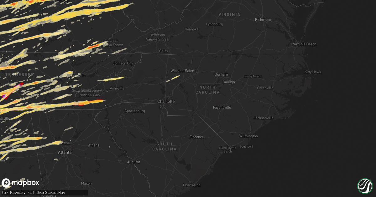
Hail Map in North Carolina on March 2, 2012
Get this storm
March 2 map
$229
one time, instant access
Download today. No call, no setup
Keep the $229
Bought the map and want the full workflow? Apply the entire $229 to a subscription within 7 days. None of it is wasted.
Every map, not just this one
This buys you this map. Subscription and you get every map we run, in the markets you choose from a few cities to whole states to nationwide. Plus real-time alerts the moment a storm fires.
Contact data
Name, contact info, occupancy, even credit band for addresses in the footprint. You go from where it hit to who to call.
Become the source they trust
Unlimited branding weather history reports on demand. You already have the documented answer ready for the property owner, and you are the one who showed up with it.
Property data and RoofTrace estimates
Pull up any address you have got, its value and the exact code rules for that jurisdiction, straight from One Click Code. Then RoofTrace estimates the squares, pitch, and roof value, priced the way you price.
Storm reports in North Carolina
North Carolina
| Date | Description |
|---|---|
| 03/02/201212:40 PM CST | Severe damage to a home including windows broken and collapsed garage. Several large trees and power lines reported down. |
| 03/02/201210:30 AM CST | A local report indicates 1.50 inch wind near MOCKSVILLE |
| 03/02/20123:52 AM CST | Dispatch reported trees down countywide. |
| 03/02/20123:15 AM CST | Multiple trees down with damage to a house on glovers church road |
| 03/02/20123:00 AM CST | Several small to medium softwood trees uprooted and down. Small section of tin blown off barn roof. Straightline thunderstorm wind gust estimated at 65 mph. |
| 03/02/20123:00 AM CST | Several small to medium softwood trees uprooted and down. Straightline thunderstorm wind gust estimated at 65 mph. |
| 03/02/20122:40 AM CST | Tree down on a home on emmanuel church road in seagrove. Report relayed by emergency manager. Time estimated by radar. |
| 03/02/20122:10 AM CST | Two old barns were blown down and one home sustained minor damage on substation road. |
| 03/02/20121:37 AM CST | Preliminary reports of six houses damaged and trees and other debris in the road south of harrisburg...generally between robinson church road and 485. Damage also noted |
| 03/02/20121:36 AM CST | Charlotte-mecklenburg fire marshall reports damage in far eastern mecklenburg there is damage in the plaza road extension area. Officials are in the area and will have |
| 03/01/20128:09 PM CST | Numerous trees snapped and uprooted at the intersection of pine creek and north norton roads. |
| 03/01/20128:05 PM CST | Trees down along pine creek road. One tree that fell on a brand new car. Debris in the road near pine creek road and cullowhee road. |
| 03/01/20128:05 PM CST | Golf ball sized hail reported in south central jackson county as storm passed. |
| 03/01/20127:58 PM CST | Fire department in cullasaja had hail larger than golf ball but likely a bit less than tennis ball. Therefore...lime sized hail fell at their location. |
| 03/01/20127:50 PM CST | Golf ball sized hail fell in or near franklin as storm passed. Got a report from a traveler passing through about a mile north of downtown franklin of very strong wind |
| 03/01/20127:48 PM CST | Golf ball hail and trees down |
| 03/01/20127:45 PM CST | A few trees down near franklin. |
| 03/01/20127:45 PM CST | Spotter under the storm reported hail one and a half inch diameter. Does not know of any wind damage in his area. |
| 03/01/20127:38 PM CST | Golf ball hail and several trees down |
| 03/01/20127:37 PM CST | Quarter sized hail lasted a few minutes near yancey county border not far from mars hill. |
| 03/01/20127:30 PM CST | Golf ball sized hail as storm crossed. |
| 03/01/20127:26 PM CST | A hail producing storm crossed madison county with the largest hail reported between walnut and mars hill. Spotter halfway between those locations reported sounded like |
| 03/01/20127:25 PM CST | Numerous trees down in the nantahala area. |
| 03/01/20127:05 PM CST | Ef2 tornado...120 mph max winds. Moderate to major damage to buisnesses as well as homes. |
| 03/01/20127:03 PM CST | Possible tornado...damage to several buildings and a few homes destroyed. Numerous trees down across murphy. |
| 03/01/20127:00 PM CST | Multiple power lines down |
| 03/01/20126:50 PM CST | Murphy power reports multiple power lines down |
All States Impacted by Hail Map on March 2, 2012
Cities Impacted by Hail Map on March 2, 2012
- Starkville, MS
- Oakdale, IL
- Coulterville, IL
- Salyersville, KY
- West Liberty, KY
- Cannel City, KY
- Saint Charles, MO
- Bowling Green, KY
- Rockfield, KY
- Amory, MS
- Aberdeen, MS
- Okolona, MS
- Fyffe, AL
- Geraldine, AL
- Sewanee, TN
- Winchester, TN
- Johnsonville, IL
- Iuka, IL
- Ladoga, IN
- Roachdale, IN
- Morris, AL
- Pinson, AL
- Ashville, AL
- Jacksonville, AL
- Ohatchee, AL
- Wellington, AL
- Holcomb, MS
- Unionville, TN
- Readyville, TN
- Lewisburg, TN
- Rockvale, TN
- Murfreesboro, TN
- Bradyville, TN
- Beechgrove, TN
- Bell Buckle, TN
- Christiana, TN
- Woodbury, TN
- Mcminnville, TN
- Chapel Hill, TN
- Anguilla, MS
- Richmond, IN
- Keyesport, IL
- Smithboro, IL
- Greenville, IL
- Mason, IL
- Watson, IL
- Effingham, IL
- Altamont, IL
- Brownstown, IL
- Saint Elmo, IL
- Pelahatchie, MS
- Brandon, MS
- Morton, MS
- Ethridge, TN
- Saint Anthony, IN
- Huntingburg, IN
- Birdseye, IN
- Dubois, IN
- Jasper, IN
- Celestine, IN
- Mount Vernon, IN
- Sandy Hook, KY
- Isonville, KY
- Gallipolis, OH
- Thurman, OH
- Patriot, OH
- Gallipolis Ferry, WV
- Henderson, WV
- Bidwell, OH
- Oak Hill, OH
- Point Pleasant, WV
- Cedarbluff, MS
- Pheba, MS
- Gate City, VA
- Weber City, VA
- Hiltons, VA
- Staunton, IL
- Gillespie, IL
- Wilsonville, IL
- Benld, IL
- Bunker Hill, IL
- Sawyerville, IL
- Mount Olive, IL
- Newcomb, TN
- Jellico, TN
- Williamsburg, KY
- Tupelo, MS
- Mooreville, MS
- Thomasville, AL
- Pine Hill, AL
- Camden, AL
- Coy, AL
- Coffeeville, AL
- Grove Hill, AL
- Lower Peach Tree, AL
- Scottsville, KY
- Pitkin, LA
- Richmond, KY
- Stanton, KY
- Winchester, KY
- Frenchburg, KY
- Means, KY
- Jeffersonville, KY
- Clay City, KY
- Pontotoc, MS
- Murphysboro, IL
- Waverly, TN
- Carthage, TN
- White Bluff, TN
- Elmwood, TN
- Kingston Springs, TN
- Holladay, TN
- Hermitage, TN
- Nashville, TN
- New Johnsonville, TN
- Burns, TN
- Mount Juliet, TN
- Lebanon, TN
- Pegram, TN
- Dickson, TN
- McEwen, TN
- Camden, TN
- Watertown, TN
- Fairview, TN
- Gordonsville, TN
- Hurricane Mills, TN
- Baskin, LA
- Delhi, LA
- Millstadt, IL
- Columbia, IL
- Belleville, IL
- Dupo, IL
- East Carondelet, IL
- Lawrenceburg, TN
- Savannah, TN
- Loretto, TN
- Westpoint, TN
- Leoma, TN
- Pulaski, TN
- Collinwood, TN
- Lutts, TN
- Iron City, TN
- Waterloo, AL
- Cypress Inn, TN
- Bessemer, AL
- New Ross, IN
- Advance, IN
- Russellville, IN
- Jamestown, IN
- Cohutta, GA
- Crandall, GA
- Dalton, GA
- New Market, AL
- Ardmore, TN
- Taft, TN
- Fayetteville, TN
- Ardmore, AL
- Kelso, TN
- Hazel Green, AL
- Athens, AL
- Elkmont, AL
- Toney, AL
- Enid, MS
- Pope, MS
- Etta, MS
- Guntown, MS
- Batesville, MS
- New Albany, MS
- Oxford, MS
- Blue Springs, MS
- Thaxton, MS
- Water Valley, MS
- Courtland, MS
- Baldwyn, MS
- Taylor, MS
- Myrtle, MS
- Georgetown, OH
- Poseyville, IN
- Manchester, TN
- Beech Bluff, TN
- Jackson, TN
- Medon, TN
- Grantsburg, IN
- English, IN
- Hartselle, AL
- Danville, AL
- Oliver Springs, TN
- Cub Run, KY
- Mammoth Cave, KY
- Flintstone, GA
- Rossville, GA
- Gattman, MS
- Detroit, AL
- Sulligent, AL
- Greenwood Springs, MS
- Fayette, AL
- Vernon, AL
- Kennedy, AL
- Elizabethtown, IN
- Westport, IN
- Greensburg, IN
- Hartsville, IN
- Columbus, IN
- Bedford, KY
- Hanover, IN
- Nabb, IN
- Scottsburg, IN
- Milton, KY
- Lexington, IN
- Houston, OH
- Piqua, OH
- Covington, OH
- Clay City, IL
- Dix, IL
- Kell, IL
- Texico, IL
- Centre, AL
- Lewisburg, KY
- Dunmor, KY
- Belton, KY
- Greenville, KY
- Elkton, KY
- Estill Springs, TN
- Lascassas, TN
- Mooreland, IN
- New Castle, IN
- Losantville, IN
- Killen, AL
- Florence, AL
- Cherokee, AL
- Warren, IN
- Grant, AL
- Hillsboro, IL
- Livingston, IL
- Moro, IL
- South Roxana, IL
- Beecher City, IL
- Roxana, IL
- East Alton, IL
- Wood River, IL
- Saint Louis, MO
- West Alton, MO
- Hamel, IL
- Fillmore, IL
- Florissant, MO
- Cowden, IL
- Edwardsville, IL
- Granite City, IL
- Cottage Hills, IL
- Worden, IL
- Ramsey, IL
- Coffeen, IL
- Bingham, IL
- Sorento, IL
- Bethalto, IL
- Hartford, IL
- Alton, IL
- Herrick, IL
- Godfrey, IL
- Alhambra, IL
- Dorsey, IL
- New Douglas, IL
- Donnellson, IL
- Toxey, AL
- Campbell, AL
- Dixons Mills, AL
- Silas, AL
- Arlington, AL
- Gilbertown, AL
- Glasgow, KY
- Cromwell, KY
- Horse Branch, KY
- Beaver Dam, KY
- Leitchfield, KY
- Caneyville, KY
- Millwood, KY
- Sweet Water, AL
- Bastrop, LA
- Tuckasegee, NC
- Franklin, NC
- Sylva, NC
- Glenville, NC
- Cullowhee, NC
- Dixon, KY
- Clay, KY
- Winnsboro, LA
- Mangham, LA
- Waverly, KY
- Crawford, MS
- Columbus, MS
- Joelton, TN
- Ashland City, TN
- Farmerville, LA
- Simsboro, LA
- Ruston, LA
- Sterlington, LA
- Choudrant, LA
- Gibsland, LA
- Arcadia, LA
- Marion, LA
- Dubach, LA
- Downsville, LA
- Louisa, KY
- Morehead, KY
- Wayne, WV
- Fort Gay, WV
- Grayson, KY
- Webbville, KY
- Clearfield, KY
- Catlettsburg, KY
- Olive Hill, KY
- Prichard, WV
- Salt Lick, KY
- Coalmont, TN
- Beersheba Springs, TN
- Palmer, TN
- Dunlap, TN
- Gruetli Laager, TN
- Pikeville, TN
- Altamont, TN
- Rogersville, AL
- Muscle Shoals, AL
- Gipsy, MO
- Greenville, MO
- Lowndes, MO
- Marble Hill, MO
- Zalma, MO
- Evansville, IN
- Kennesaw, GA
- Acworth, GA
- London, KY
- East Bernstadt, KY
- Hamlin, WV
- Myra, WV
- Branchland, WV
- Hulen, KY
- Evarts, KY
- Pineville, KY
- Wallins Creek, KY
- Ages Brookside, KY
- Kenvir, KY
- Miracle, KY
- Coalgood, KY
- Cawood, KY
- Grays Knob, KY
- Mary Alice, KY
- Pathfork, KY
- Middlesboro, KY
- Harlan, KY
- Gulston, KY
- Duck Hill, MS
- Hamilton, AL
- Woodland, MS
- Mantee, MS
- Beaverton, AL
- Hamilton, MS
- Gore Springs, MS
- Nettleton, MS
- Vardaman, MS
- Eupora, MS
- Maben, MS
- Prairie, MS
- Smithville, MS
- Calhoun City, MS
- Stewart, MS
- West Point, MS
- Bellefontaine, MS
- Houston, MS
- Lebanon Junction, KY
- Shepherdsville, KY
- Westfield, IL
- Toledo, IL
- Kansas, IL
- Charleston, IL
- Casey, IL
- Ashmore, IL
- Lerna, IL
- Trilla, IL
- Quitman, LA
- Bienville, LA
- Trussville, AL
- Springville, AL
- Shannon, MS
- New Liberty, KY
- Jonesville, KY
- Dry Ridge, KY
- Sanders, KY
- Sparta, KY
- Glencoe, KY
- Williamsport, KY
- Thelma, KY
- Beattyville, KY
- West Van Lear, KY
- Rogers, KY
- Oil Springs, KY
- Mize, KY
- Tomahawk, KY
- Meally, KY
- Hazel Green, KY
- Paintsville, KY
- Tutor Key, KY
- Staffordsville, KY
- Boons Camp, KY
- Campton, KY
- Slade, KY
- Hagerhill, KY
- Pine Ridge, KY
- Philadelphia, TN
- Niota, TN
- Soddy Daisy, TN
- Decatur, TN
- Sale Creek, TN
- Ten Mile, TN
- Athens, TN
- Sweetwater, TN
- Greenback, TN
- Evensville, TN
- Vonore, TN
- Loudon, TN
- Graysville, TN
- Dayton, TN
- Madisonville, TN
- Berry, AL
- Oakman, AL
- Parrish, AL
- Mount Sterling, KY
- Paris, KY
- Winfield, TN
- Oneida, TN
- Marshall, IN
- Rockville, IN
- Chattanooga, TN
- Pleasant Hill, LA
- Coushatta, LA
- Jonesboro, LA
- Winnfield, LA
- Goldonna, LA
- Robeline, LA
- Pelican, LA
- Dodson, LA
- Campti, LA
- Saline, LA
- Michie, TN
- Shiloh, TN
- Ramer, TN
- Selmer, TN
- Guys, TN
- Stantonville, TN
- Scottsboro, AL
- Birmingham, AL
- Dallas, GA
- Edmonton, KY
- Lynnville, TN
- Summertown, TN
- Jasper, TX
- Wiergate, TX
- Newton, TX
- Burkeville, TX
- Rockport, IN
- Olla, LA
- Mississippi State, MS
- Sharpsburg, KY
- Carlisle, KY
- Gardendale, AL
- Murphy, NC
- Prospect, TN
- Gurley, AL
- Middleton, TN
- Hillsboro, TN
- Ocoee, TN
- Meridianville, AL
- Ringgold, GA
- Holly Springs, MS
- Andrews, NC
- Topton, NC
- Harriman, TN
- McDonald, TN
- Decherd, TN
- Harvest, AL
- Sherwood, TN
- Frankewing, TN
- Normandy, TN
- Tuscumbia, AL
- Sardis, TN
- Leighton, AL
- Hollywood, AL
- Cleveland, TN
- Rockwood, TN
- Shelbyville, TN
- Fort Oglethorpe, GA
- Fackler, AL
- Culleoka, TN
- Morris Chapel, TN
- Saltillo, TN
- Saulsbury, TN
- Adamsville, TN
- Iuka, MS
- Tishomingo, MS
- Counce, TN
- Moscow, TN
- Bryant, AL
- Whitwell, TN
- Sequatchie, TN
- Belfast, TN
- Wildwood, GA
- Marble, NC
- Crump, TN
- Hixson, TN
- Grand Junction, TN
- Harrison, TN
- Farner, TN
- Petersburg, TN
- Benton, TN
- Dennis, MS
- Madison, AL
- Huntland, TN
- Reliance, TN
- Waynesboro, TN
- Stevenson, AL
- Rossville, TN
- Elora, TN
- Byhalia, MS
- Spring City, TN
- Cowan, TN
- Bethel Springs, TN
- Red Banks, MS
- Flat Rock, AL
- Turtletown, TN
- Copperhill, TN
- Courtland, AL
- Old Fort, TN
- Morrison, TN
- Ooltewah, TN
- Whiteside, TN
- Lookout Mountain, GA
- Jasper, TN
- Belvidere, TN
- South Pittsburg, TN
- Cornersville, TN
- Flintville, TN
- Hornsby, TN
- Woodville, AL
- Estillfork, AL
- Trenton, GA
- Town Creek, AL
- Grandview, TN
- Huntsville, AL
- Wartrace, TN
- Pocahontas, TN
- Signal Mountain, TN
- Lamar, MS
- Dellrose, TN
- Pelham, TN
- La Grange, TN
- Spencer, TN
- Sheffield, AL
- Monteagle, TN
- Bridgeport, AL
- Olivehill, TN
- Rock Island, TN
- Lester, AL
- Mulberry, TN
- Hayesville, NC
- Hillsboro, AL
- Guild, TN
- Crossville, TN
- Tracy City, TN
- Apison, TN
- Lookout Mountain, TN
- Paint Rock, AL
- Tanner, AL
- Russellville, AL
- Foster, KY
- Greenville, MS
- Lake Village, AR
- Mount Eden, KY
- Walnut Hill, IL
- Odin, IL
- Nashville, IL
- Centralia, IL
- Salem, IL
- Addieville, IL
- Hoyleton, IL
- Shelbyville, KY
- Owensboro, KY
- Morganfield, KY
- Calhoun, KY
- Sebree, KY
- Nebo, KY
- Pittsboro, MS
- Houlka, MS
- Durant, MS
- Vaiden, MS
- Mathiston, MS
- Hollandale, MS
- Millport, AL
- Silver City, MS
- Louise, MS
- Tchula, MS
- Ackerman, MS
- Kilmichael, MS
- Lexington, MS
- West, MS
- Coila, MS
- Ethel, MS
- Steens, MS
- Weir, MS
- French Camp, MS
- Cruger, MS
- Belzoni, MS
- Sturgis, MS
- Fulton, MO
- Science Hill, KY
- Somerset, KY
- Guntersville, AL
- Stonington, IL
- Taylorville, IL
- Palmer, IL
- Morrisonville, IL
- North Salem, IN
- Salem, IN
- Pekin, IN
- Sharon Grove, KY
- Indianola, MS
- Crossett, AR
- Portland, AR
- Doddsville, MS
- Moorhead, MS
- Hamburg, AR
- Dermott, AR
- Leland, MS
- Montrose, AR
- Inverness, MS
- Shaw, MS
- Itta Bena, MS
- Uniontown, KY
- Henderson, KY
- Corydon, KY
- Oak Grove, LA
- Sturgis, KY
- Utica, KY
- Farina, IL
- Shoals, IN
- Columbia, LA
- Olney, IL
- Noble, IL
- Carmi, IL
- Indianapolis, IN
- Avon, IN
- Carmel, IN
- Center, TX
- Leesville, LA
- Anacoco, LA
- Evans, LA
- Campbellsburg, IN
- Pana, IL
- Tower Hill, IL
- Vanceburg, KY
- Stout, OH
- Jena, LA
- Jonesville, LA
- Grayson, LA
- Rayville, LA
- Monroe, LA
- Chatham, LA
- Vicksburg, MS
- Redwood, MS
- Bolton, MS
- Tallulah, LA
- Bentonia, MS
- Sikes, LA
- Columbia, KY
- Alexander City, AL
- Jamestown, TN
- Borden, IN
- Yazoo City, MS
- Rolling Fork, MS
- Morgantown, KY
- La Fontaine, IN
- Converse, IN
- Amboy, IN
- Celina, TN
- Tompkinsville, KY
- Burkesville, KY
- Paris, IL
- Owingsville, KY
- Greenwood, IN
- Holton, IN
- North Vernon, IN
- Butlerville, IN
- Scipio, IN
- Gays, IL
- Windsor, IL
- Woodstock, AL
- West Blocton, AL
- Bethel, OH
- New Richmond, OH
- Moscow, OH
- California, KY
- Alexandria, KY
- Gravel Switch, KY
- Parksville, KY
- Bradfordsville, KY
- Lebanon, KY
- Homer, LA
- Bernice, LA
- Marion, IN
- Waterford, MS
- Potts Camp, MS
- Nancy, KY
- Hartsville, TN
- Castalian Springs, TN
- Bethpage, TN
- Whitleyville, TN
- Moss, TN
- Gallatin, TN
- Gamaliel, KY
- Dixon Springs, TN
- Lafayette, TN
- Red Boiling Springs, TN
- Greenup, IL
- Mattoon, IL
- Martinsville, IL
- Neoga, IL
- Winchester, OH
- Michigan City, MS
- Ashland, MS
- Mount Washington, KY
- Bardstown, KY
- Deatsville, AL
- Titus, AL
- Marbury, AL
- Holly Pond, AL
- New Hope, KY
- Loretto, KY
- New Haven, KY
- Ekron, KY
- Brandenburg, KY
- Guston, KY
- Irvington, KY
- South Shore, KY
- Pedro, OH
- Greenup, KY
- Franklin Furnace, OH
- Wheelersburg, OH
- South Webster, OH
- New Harmony, IN
- Crossville, IL
- Genoa, WV
- Wellington, KY
- East Lynn, WV
- Waco, KY
- Ezel, KY
- Dunlow, WV
- Elkfork, KY
- Adams, KY
- Martha, KY
- Blaine, KY
- Breese, IL
- Trenton, IL
- Aviston, IL
- Carlyle, IL
- Tunnel Hill, GA
- Hillsdale, IN
- Dana, IN
- Chrisman, IL
- Taylorsville, KY
- Knightsville, IN
- Staunton, IN
- Brazil, IN
- Buchanan, GA
- Cedartown, GA
- Whiteville, TN
- Bolivar, TN
- Somerville, TN
- Dawson, AL
- Warsaw, KY
- Florence, IN
- Patriot, IN
- Rising Sun, IN
- Vevay, IN
- Ghent, KY
- Owenton, KY
- Carrollton, KY
- Turners Station, KY
- Worthville, KY
- Campbellsburg, KY
- West Newton, IN
- Camby, IN
- Burnside, KY
- Bronston, KY
- Martinsville, IN
- Bentley, LA
- Pollock, LA
- Booneville, KY
- Lebanon, IN
- Rineyville, KY
- Ellsinore, MO
- Bainbridge, IN
- Greencastle, IN
- Yawkey, WV
- Sod, WV
- Sumerco, WV
- Norris City, IL
- Enfield, IL
- Hagerstown, IN
- Madison, IN
- Joaquin, TX
- Nacogdoches, TX
- Zwolle, LA
- Chireno, TX
- San Augustine, TX
- Marthaville, LA
- Noble, LA
- Atlanta, LA
- Natchitoches, LA
- Converse, LA
- Belmont, LA
- Shelbyville, TX
- Campbellsville, KY
- Raywick, KY
- Magnolia, KY
- Buffalo, KY
- Mount Sherman, KY
- Wildersville, TN
- Coldiron, KY
- Dayhoit, KY
- Baxter, KY
- Bledsoe, KY
- Putney, KY
- Clayton, IN
- Knoxville, TN
- Irvine, KY
- Crab Orchard, KY
- Danville, KY
- Lancaster, KY
- Berea, KY
- Paint Lick, KY
- Stanford, KY
- Carthage, IN
- Knightstown, IN
- Patoka, IN
- Deputy, IN
- Highland, IL
- Advance, NC
- Mocksville, NC
- Columbia, TN
- Terre Haute, IN
- Owens Cross Roads, AL
- Abbeville, MS
- Decatur, IL
- Friedheim, MO
- Fredericktown, MO
- Sedgewickville, MO
- Perryville, MO
- Marquand, MO
- Farrar, MO
- Patton, MO
- Frohna, MO
- Hardyville, KY
- Munfordville, KY
- Roundhill, KY
- Bonnieville, KY
- Horse Cave, KY
- Canmer, KY
- Brownsville, KY
- Aliceville, AL
- Carrollton, AL
- Macon, MS
- Maryville, TN
- Montgomery City, MO
- Junction, IL
- Kermit, WV
- Breeden, WV
- Winfield, AL
- Guin, AL
- Hardinsburg, KY
- Webster, KY
- Cannelton, IN
- Rome, IN
- Lewisport, KY
- Payneville, KY
- Stephensport, KY
- Hawesville, KY
- Union Star, KY
- Philpot, KY
- Maceo, KY
- Laconia, IN
- Helenwood, TN
- Duff, TN
- Frakes, KY
- Clairfield, TN
- Holmes Mill, KY
- Closplint, KY
- Hodgenville, KY
- Cookeville, TN
- Jonesboro, IN
- Swayzee, IN
- Cambridge City, IN
- Straughn, IN
- Greens Fork, IN
- Meridian, MS
- De Kalb, MS
- Daleville, MS
- Collinsville, MS
- Bailey, MS
- Cuba, AL
- Toomsuba, MS
- Mitchell, IN
- West Baden Springs, IN
- French Lick, IN
- Orleans, IN
- Strunk, KY
- Deridder, LA
- Merryville, LA
- Rosepine, LA
- Kirbyville, TX
- Centertown, KY
- Carrollton, MS
- Winona, MS
- Greenwood, MS
- Woodworth, LA
- Alexandria, LA
- Gainesboro, TN
- Granville, TN
- Chandler, IN
- Stilesville, IN
- Mooresville, IN
- Monrovia, IN
- Universal, IN
- Hidalgo, IL
- Fillmore, IN
- Rosedale, IN
- Harmony, IN
- Wheeler, IL
- Yale, IL
- Mecca, IN
- Centerpoint, IN
- Carbon, IN
- Amo, IN
- Cloverdale, IN
- Oblong, IL
- Willow Hill, IL
- Plainfield, IN
- Waveland, IN
- Riley, IN
- Reelsville, IN
- Greenfield, IN
- New Goshen, IN
- West York, IL
- Cory, IN
- Newton, IL
- Putnamville, IN
- Poland, IN
- West Union, IL
- Beech Grove, IN
- Marshall, IL
- Montezuma, IN
- Coatesville, IN
- Clinton, IN
- Annapolis, IL
- Crawfordsville, IN
- Dennison, IL
- West Terre Haute, IN
- Danville, IN
- Sondheimer, LA
- Epps, LA
- Pioneer, LA
- Lake Providence, LA
- Pleasureville, KY
- Lockport, KY
- Bethlehem, KY
- West Liberty, IL
- Dundas, IL
- Ethelsville, AL
- Marysville, IN
- Monterey, TN
- Clarkrange, TN
- Pennington Gap, VA
- Pioneer, TN
- La Follette, TN
- Cranks, KY
- Speedwell, TN
- Saint Charles, VA
- Goodman, MS
- Kosciusko, MS
- Pickens, MS
- McCool, MS
- Sallis, MS
- Benton, MS
- Moody, AL
- Odenville, AL
- Lexington, TN
- Westport, TN
- Old Hickory, TN
- Madison, TN
- Milam, TX
- Eckerty, IN
- Bristow, IN
- Nicholasville, KY
- Calhoun, LA
- West Monroe, LA
- Ridgeland, MS
- Jackson, MS
- Madison, MS
- White Hall, IL
- Clarksville, MO
- Annada, MO
- Hamburg, IL
- Kampsville, IL
- Elsberry, MO
- Eldred, IL
- Roodhouse, IL
- Silex, MO
- Hillview, IL
- Eolia, MO
- Nebo, IL
- Bellflower, MO
- Murrayville, IL
- Salem, KY
- Burnsville, NC
- Hot Springs, NC
- Hartford, TN
- Mars Hill, NC
- Del Rio, TN
- Marshall, NC
- Cosby, TN
- Jones, LA
- Bonita, LA
- Eudora, AR
- Princeton, IN
- Dunkirk, IN
- Muncie, IN
- Albany, IN
- McCalla, AL
- Trout, LA
- Sicily Island, LA
- Harrisonburg, LA
- Ferriday, LA
- Mayersville, MS
- Glen Allan, MS
- Mer Rouge, LA
- Mill Spring, MO
- Brownsburg, IN
- Pittsboro, IN
- Sandoval, IL
- Robards, KY
- Tazewell, TN
- Rose Hill, VA
- Jonesville, VA
- Ozark, IL
- Simpson, IL
- Vienna, IL
- Stonefort, IL
- Farragut, TN
- Lenoir City, TN
- Falmouth, IN
- Milton, IN
- Connersville, IN
- Central City, KY
- Clarkson, KY
- McHenry, KY
- Glendale, KY
- Sacramento, KY
- Madisonville, KY
- Island, KY
- Hartford, KY
- Falls Of Rough, KY
- Rosine, KY
- White Mills, KY
- Princeton, KY
- Fredonia, KY
- Dawson Springs, KY
- Sonora, KY
- Providence, KY
- Eastview, KY
- Manitou, KY
- Bremen, KY
- Big Clifty, KY
- Gracey, KY
- Crofton, KY
- Hardin, KY
- Cerulean, KY
- Cadiz, KY
- Hopkinsville, KY
- Benton, KY
- Cordova, AL
- Gadsden, AL
- Steele, AL
- Blountsville, AL
- Oneonta, AL
- Empire, AL
- Locust Fork, AL
- Leesburg, AL
- Jasper, AL
- Hayden, AL
- Rome, GA
- Cullman, AL
- Altoona, AL
- Collinsville, AL
- Hanceville, AL
- Bremen, AL
- Townley, AL
- Cleveland, AL
- Cave Spring, GA
- Attalla, AL
- Lindale, GA
- Boaz, AL
- Warrior, AL
- Quinton, AL
- Eddyville, IL
- Bryson City, NC
- Langston, AL
- Buena Vista, TN
- Huntingdon, TN
- Moorefield, KY
- Ewing, KY
- Flemingsburg, KY
- Gordo, AL
- Dora, AL
- Elrod, AL
- Mount Olive, AL
- Echola, AL
- Buhl, AL
- Graysville, AL
- Sumiton, AL
- Tuscaloosa, AL
- Coker, AL
- Northport, AL
- Tignall, GA
- Kelly, LA
- Tullos, LA
- Cleveland, NC
- Statesville, NC
- Vincent, KY
- Rushville, IN
- Cumberland Gap, TN
- Ewing, VA
- Harrogate, TN
- Belle Center, OH
- Huntsville, OH
- Bellefontaine, OH
- Walnut, MS
- Anna, IL
- Dongola, IL
- Buncombe, IL
- Nauvoo, AL
- Crane Hill, AL
- Arley, AL
- Double Springs, AL
- Marietta, GA
- Ashford, WV
- Alum Creek, WV
- Auburn, KY
- Russellville, KY
- Livingston, TN
- Mayfield, KY
- Brooksville, MS
- Gilbert, LA
- O'Fallon, MO
- Macedonia, IL
- McLeansboro, IL
- Willow Wood, OH
- Scottown, OH
- Kitts Hill, OH
- Bruce, MS
- Bear Creek, AL
- Big Creek, MS
- Coffeeville, MS
- Grenada, MS
- McCarley, MS
- Haleyville, AL
- Caledonia, MS
- Fulton, MS
- Plantersville, MS
- Tremont, MS
- Amherstdale, WV
- Bim, WV
- Clothier, WV
- Yolyn, WV
- Sullivan, IL
- Oconee, IL
- Findlay, IL
- Lakewood, IL
- Shelbyville, IL
- Eutaw, AL
- Spurlockville, WV
- Alkol, WV
- Denniston, KY
- Lowmansville, KY
- Keaton, KY
- Ranger, WV
- Midkiff, WV
- Julian, WV
- Griffithsville, WV
- Kiahsville, WV
- Peebles, OH
- West Union, OH
- Saint Meinrad, IN
- Ferdinand, IN
- Walland, TN
- Townsend, TN
- Tallassee, TN
- Goodlettsville, TN
- Smiths Grove, KY
- Park City, KY
- Cave City, KY
- Tell City, IN
- Robbins, TN
- Albertville, AL
- Groveoak, AL
- Amelia, OH
- Crown City, OH
- Glenwood, WV
- Lesage, WV
- Nokomis, IL
- Phil Campbell, AL
- Smithland, KY
- Brookport, IL
- Tiline, KY
- Grand Rivers, KY
- Paducah, KY
- Marion, KY
- Walling, TN
- Quebeck, TN
- Livingston, AL
- York, AL
- Powell, TN
- Clinton, TN
- Oak Ridge, TN
- Bridgeton, MO
- Saint Ann, MO
- Hazelwood, MO
- Earth City, MO
- Tennyson, IN
- Boonville, IN
- Kevil, KY
- Golconda, IL
- Karnak, IL
- Grand Chain, IL
- Metropolis, IL
- Olmsted, IL
- Hampton, KY
- Belknap, IL
- Grantsburg, IL
- La Center, KY
- Felicity, OH
- Francisco, IN
- Fort Branch, IN
- Owensville, IN
- Cynthiana, IN
- Oakland City, IN
- Haubstadt, IN
- Reform, AL
- Oakland, KY
- Alvaton, KY
- Mount Vernon, KY
- Russell Springs, KY
- Knob Lick, KY
- Liberty, KY
- Gradyville, KY
- Eubank, KY
- Franklin, KY
- Summer Shade, KY
- Woodburn, KY
- Adairville, KY
- Dunnville, KY
- Windsor, KY
- Centerville, IN
- Eldorado, OH
- Lewisville, IN
- Webster, IN
- Williamsburg, IN
- New Paris, OH
- West Manchester, OH
- Lynn, IN
- Economy, IN
- New Madison, OH
- Fountain City, IN
- Hazleton, IN
- Depauw, IN
- Palmyra, IN
- Eminence, KY
- Kingston, TN
- Mount Olivet, KY
- Mayslick, KY
- Uniontown, AL
- Marion, AL
- De Soto, IL
- Fort Payne, AL
- Cedar Bluff, AL
- Isola, MS
- Canton, MS
- Wisner, LA
- Xenia, IL
- Marble Hill, GA
- Ball Ground, GA
- Altenburg, MO
- Tullahoma, TN
- Spartanburg, SC
- Olympia, KY
- Lake Toxaway, NC
- Sapphire, NC
- Versailles, KY
- Coxs Creek, KY
- Waddy, KY
- Lawrenceburg, KY
- Frankfort, KY
- Brooks, KY
- Midway, KY
- Noblesville, IN
- Hardinsburg, IN
- Fredericksburg, IN
- Louisville, MS
- Heiskell, TN
- Eros, LA
- Inez, KY
- Zoe, KY
- Wilsondale, WV
- River, KY
- Junction City, KY
- Crum, WV
- Dingess, WV
- Beauty, KY
- Wittensville, KY
- Warfield, KY
- Ravenna, KY
- Debord, KY
- Sitka, KY
- Dow, IL
- Portage Des Sioux, MO
- Elsah, IL
- Grafton, IL
- Clanton, AL
- Maplesville, AL
- Whitesville, KY
- Witt, IL
- Ashley, IL
- Saint Peter, IL
- Kinmundy, IL
- Bloomington, IN
- Fenton, MO
- Arnold, MO
- Sieper, LA
- Seaman, OH
- Hillsboro, OH
- Benton, MO
- Charleston, MO
- Oran, MO
- Sikeston, MO
- Vanduser, MO
- Bell City, MO
- Scott City, MO
- Williamstown, KY
- Glens Fork, KY
- Wabash, IN
- Greentown, IN
- Kokomo, IN
- Apple Grove, WV
- Lexington, KY
- Georgetown, KY
- Southside, WV
- New Albany, IN
- Clarksville, IN
- Jeffersonville, IN
- Ironton, OH
- Summersville, KY
- Verona, KY
- Bennington, IN
- Union, KY
- Cedar Grove, TN
- Lavinia, TN
- Pinson, TN
- Griffin, IN
- Hermanville, MS
- West Lafayette, IN
- Alexandria, AL
- Raymond, MS
- Colfax, LA
- Boyce, LA
- Dry Prong, LA
- Lena, LA
- Fultondale, AL
- Union City, IN
- Austin, IN
- Panama, IL
- Jerseyville, IL
- Mulberry Grove, IL
- Glen Carbon, IL
- Marine, IL
- Otwell, IN
- Fraziers Bottom, WV
- Jonesboro, IL
- Harrisburg, IL
- Elizabethtown, IL
- Reed, KY
- Herod, IL
- Equality, IL
- Shawneetown, IL
- Carrier Mills, IL
- Goreville, IL
- Spottsville, KY
- Tamms, IL
- Russellville, OH
- Elmer, LA
- Pine Knot, KY
- Henderson, TN
- Elwood, IN
- Windfall, IN
- Richview, IL
- Okawville, IL
- Simpson, LA
- Slagle, LA
- Cecilia, KY
- Jewett, IL
- Union Grove, AL
- Brilliant, AL
- Fruithurst, AL
- Louisville, KY
- Crestwood, KY
- Pewee Valley, KY
- Camden, SC
- Westville, SC
- Chapmanville, WV
- Vancleve, KY
- Perryville, KY
- Lovely, KY
- Jackson, KY
- Greensburg, KY
- Upton, KY
- Hope, KY
- East Point, KY
- Harts, WV
- Kirksey, KY
- Hustonville, KY
- Van Lear, KY
- Jetson, KY
- South Charleston, WV
- Boligee, AL
- Suwanee, GA
- Alpharetta, GA
- Cumming, GA
- Ansonia, OH
- Union City, OH
- Kenna, WV
- Advent, WV
- Custer, KY
- Vine Grove, KY
- Bankston, AL
- Carbon Hill, AL
- Eldridge, AL
- McClure, IL
- Whitewater, MO
- Chaffee, MO
- Glenallen, MO
- Cape Girardeau, MO
- Advance, MO
- Williamsville, MO
- Wappapello, MO
- Troy, IL
- Summerfield, IL
- O'Fallon, IL
- Saint Jacob, IL
- Lebanon, IL
- Hackleburg, AL
- Battletown, KY
- Hineston, LA
- Huntsville, TN
- Sunbright, TN
- Caryville, TN
- Whiteland, IN
- Bargersville, IN
- Rockholds, KY
- Greenville, OH
- West Paducah, KY
- Wickliffe, KY
- Blue Mountain, MS
- Lambert, MS
- Ragland, AL
- Knoxville, AL
- Adger, AL
- Piedmont, AL
- Porterville, MS
- Emelle, AL
- Scooba, MS
- Tallapoosa, GA
- Saint Francis, KY
- Eddyville, KY
- Rumsey, KY
- Earlington, KY
- Graham, KY
- Olaton, KY
- Livermore, KY
- Burna, KY
- Rockport, KY
- Hanson, KY
- Elizabethtown, KY
- Springfield, KY
- Medina, TN
- Milan, TN
- Arcanum, OH
- Hollansburg, OH
- Morristown, IN
- Palestine, OH
- Spiceland, IN
- Modoc, IN
- Mays, IN
- Arlington, IN
- Lillie, LA
- Spearsville, LA
- Sawyerville, AL
- Akron, AL
- Huntington, IN
- Roanoke, IN
- Fishers, IN
- Westfield, IN
- Moundville, AL
- Spring Hill, TN
- Mount Pleasant, TN
- College Grove, TN
- Waterloo, OH
- Newbern, AL
- Maplewood, OH
- Milltown, IN
- Taswell, IN
- Marengo, IN
- Paoli, IN
- Englewood, TN
- Frankton, IN
- Danville, IL
- Covington, IN
- Edgewood, IL
- Alma, IL
- Patoka, IL
- Dieterich, IL
- Wadesville, IN
- Spurgeon, IN
- Velpen, IN
- Gentryville, IN
- Bethlehem, IN
- Leavenworth, IN
- Dale, IL
- Ramsey, IN
- Benton, IL
- Underwood, IN
- Royalton, IL
- West Frankfort, IL
- New Haven, IL
- Logan, IL
- Elberfeld, IN
- Carterville, IL
- New Salisbury, IN
- Carbondale, IL
- Sulphur, IN
- Dale, IN
- Winslow, IN
- Otisco, IN
- Thompsonville, IL
- Schnellville, IN
- Loogootee, IN
- Stendal, IN
- Henryville, IN
- Memphis, IN
- Pendleton, KY
- Gorham, IL
- Herrin, IL
- Sulphur, KY
- Orient, IL
- Freeman Spur, IL
- Lynnville, IN
- Hurst, IL
- Santa Claus, IN
- New Washington, IN
- Bedford, IN
- Zeigler, IL
- Mulkeytown, IL
- Walton, KY
- Saint Croix, IN
- Holland, IN
- Greenville, IN
- Broughton, IL
- Elkville, IL
- Flora, IL
- Strasburg, IL
- Stewardson, IL
- Fairdale, KY
- Sidon, MS
- Williamsburg, OH
- Galatia, IL
- Floyds Knobs, IN
- Canaan, IN
- Jacob, IL
- Ripley, OH
- Independence, KY
- Crandall, IN
- Eldorado, IL
- Sellersburg, IN
- Smithfield, KY
- Morning View, KY
- Lincoln City, IN
- Marion, IL
- Neville, OH
- Energy, IL
- Omaha, IL
- Mount Orab, OH
- Grayville, IL
- Corydon, IN
- Butler, KY
- Georgetown, IN
- Pittsburg, IL
- Chrisney, IN
- Buckner, KY
- Ava, IL
- Crittenden, KY
- Heltonville, IN
- Hamersville, OH
- Charlestown, IN
- Evanston, IN
- Leopold, IN
- Lamar, IN
- De Mossville, KY
- Sardinia, OH
- La Grange, KY
- Dover, KY
- Pomona, IL
- Falmouth, KY
- Johnston City, IL
- Branchville, IN
- New Castle, KY
- Elizabeth, IN
- Muldraugh, KY
- Fisherville, KY
- West Point, KY
- Fort Knox, KY
- Richland, IN
- Rhodelia, KY
- Clermont, KY
- Hillsboro, KY
- Athens, LA
- Minden, LA
- Wilmot, AR
- Van Buren, IN
- Lanesville, IN
- Lynn, AL
- Center, KY
- Pineville, LA
- Milton, WV
- Oak Ridge, LA
- Auburntown, TN
- Shumway, IL
- Sigel, IL
- Hudson, KY
- Fordsville, KY
- McDaniels, KY
- Westview, KY
- Sparta, TN
- Lizton, IN
- Carthage, TX
- Cloverport, KY
- Cypress, IL
- Stamping Ground, KY
- Rossburg, OH
- Thomaston, AL
- Catherine, AL
- Alberta, AL
- Blackwater, VA
- Pleasant Shade, TN
- Riddleton, TN
- Leeds, AL
- Anderson, IN
- Lapel, IN
- Benton Harbor, MI
- Saint Joseph, MI
- Jackson, MO
- Oak Ridge, MO
- Owaneco, IL
- Bon Aqua, TN
- Only, TN
- Brush Creek, TN
- Yuma, TN
- Rockmart, GA
- Rainbow City, AL
- Silver Creek, GA
- Horton, AL
- Woodruff, SC
- Greer, SC
- Brent, AL
- Finchville, KY
- Newburgh, IN
- Imperial, MO
- Tougaloo, MS
- Clinton, MS
- Goshen, KY
- Dutton, AL
- Section, AL
- Smithville, TN
- Cave In Rock, IL
- New Llano, LA
- Fort Polk, LA
- Woodville, TX
- Brookwood, AL
- Cottondale, AL
- White Plains, KY
- Boggstown, IN
- Needham, IN
- Fairland, IN
- Hendersonville, TN
- Hilham, TN
- Surgoinsville, TN
- Sparta, IL
- Baldwin, IL
- Evansville, IL
- Winchester, IN
- McKee, KY
- Sandgap, KY
- Kellyton, AL
- Equality, AL
- Rockford, AL
- Slaughters, KY
- Calhoun, TN
- Etowah, TN
- Tellico Plains, TN
- Riceville, TN
- Buffalo, WV
- Leon, WV
- Radcliff, KY
- Alabaster, AL
- Cottontown, TN
- White House, TN
- Daisy, MO
- Milton, TN
- Alexandria, TN
- Liberty, TN
- Linden, TN
- Clifton, TN
- Bath Springs, TN
- Roebuck, SC
- Plantersville, AL
- Loami, IL
- Vidalia, LA
- Teutopolis, IL
- Mozelle, KY
- Mauckport, IN
- Central, IN
- Rosiclare, IL
- Vance, AL
- Edwards, MS
- Utica, MS
- Hutsonville, IL
- Ledbetter, KY
- Prospect, KY
- Franklin, IL
- Kyles Ford, TN
- Duffield, VA
- Sneedville, TN
- Collinsville, IL
- Church Hill, TN
- Kingsport, TN
- Letart, WV
- Albany, KY
- Somerville, AL
- Decatur, AL
- Moore, SC
- Portland, TN
- Liberty, WV
- Ingraham, IL
- Marissa, IL
- Bluford, IL
- Walsh, IL
- Louisville, IL
- Sainte Genevieve, MO
- Rinard, IL
- Irvington, IL
- Woodlawn, IL
- Ellis Grove, IL
- Tilden, IL
- Modoc, IL
- Lenzburg, IL
- Ridge Farm, IL
- Flat Lick, KY
- Walker, KY
- Falkville, AL
- Montrose, IL
- Union, MS
- Little Rock, MS
- Warren, TX
- West Milton, OH
- Lewisburg, OH
- Laura, OH
- Markle, IN
- Bartelso, IL
- Emerson, KY
- Madison, WV
- Jeffrey, WV
- Franklin, IN
- Collinston, LA
- Transylvania, LA
- Fairview Heights, IL
- Lynchburg, TN
- Salvisa, KY
- Harrodsburg, KY
- Kingstree, SC
- Jamestown, KY
- Shelbyville, IN
- Fountaintown, IN
- Jacksons Gap, AL
- Fort Recovery, OH
- Portland, IN
- Gaylesville, AL
- Lyerly, GA
- Corinth, MS
- Yorktown, IN
- Gaston, IN
- Wallingford, KY
- Brierfield, AL
- Duncanville, AL
- Humboldt, TN
- Alcoa, TN
- Rockford, TN
- Louisville, TN
- Vandalia, IL
- Shobonier, IL
- Mode, IL
- Pocahontas, IL
- Stearns, KY
- Mount Alto, WV
- Cottageville, WV
- Palmetto, GA
- Chatham, MS
- Houston, AL
- Gallant, AL
- Remlap, AL
- Addison, AL
- Vinemont, AL
- Ralph, AL
- Woodstock, GA
- Taylorsville, GA
- Aragon, GA
- Adamsville, AL
- Logan, AL
- Powder Springs, GA
- Muscadine, AL
- Vina, AL
- Trenton, KY
- Olmstead, KY
- Allensville, KY
- Guthrie, KY
- Burnsville, MS
- Tebbetts, MO
- Harned, KY
- Silva, MO
- Garfield, KY
- Leopold, MO
- Thebes, IL
- Reynolds Station, KY
- Andrews, IN
- Billingsley, AL
- East Saint Louis, IL
- New Baden, IL
- Germantown, IL
- Zionsville, IN
- New Palestine, IN
- Whitestown, IN
- Vernon, IL
- Beckemeyer, IL
- Eaton, IN
- Hartford City, IN
- Cynthiana, KY
- Verbena, AL
- Cayuga, IN
- Stoney Fork, KY
- Beverly, KY
- Arjay, KY
- Williston, TN
- Springfield, TN
- Cedar Hill, TN
- Keokee, VA
- Benham, KY
- Allardt, TN
- Cumberland, KY
- Dryden, VA
- Rochester, KY
- Crossville, AL
- Eva, AL
- Elk Horn, KY
- Mackville, KY
- Portland, MO
- Steedman, MO
- Charlotte, TN
- Selma, AL
- Calvin, KY
- Chunky, MS
- Decatur, MS
- Pell City, AL
- Calhoun, IL
- Falkner, MS
- Anna, OH
- Sidney, OH
- Clemmons, NC
- Woodleaf, NC
- Buffalo Valley, TN
- Willisburg, KY
- Mount Carmel, TN
- Mendota, VA
- Bristol, VA
- Irving, IL
- Rosamond, IL
- Raymond, IL
- Butler, IL
- Brodhead, KY
- Lisbon, LA
- Summerfield, LA
- Arab, AL
- Sardis, MS
- Logan, WV
- Silver Point, TN
- Baxter, TN
- Bloomfield, KY
- Williams, IN
- Lena, MS
- Forest, MS
- Otis, LA
- Docena, AL
- Mulga, AL
- Duluth, GA
- Given, WV
- Clayton, LA
- Bradford, OH
- Hartsburg, MO
- Lucas, KY
- Aurora, IN
- Dillsboro, IN
- Tilton, IL
- Catlin, IL
- Westville, IL
- Dawsonville, GA
- Danville, WV
- New Hope, AL
- Marion Junction, AL
- Parkdale, AR
- New Market, IN
- Claremont, IL
- Sumner, IL
- Westmoreland, TN
- Jasper, GA
- Sadieville, KY
- Springport, IN
- Parker City, IN
- Selma, IN
- Montevallo, AL
- Ridgeville, IN
- Middletown, MO
- Thorsby, AL
- Warbranch, KY
- Charleston, TN
- Maysville, KY
- Fort Wayne, IN
- Fort Necessity, LA
- Georgetown, LA
- Hammond, IL
- Niantic, IL
- Mccordsville, IN
- Springerton, IL


