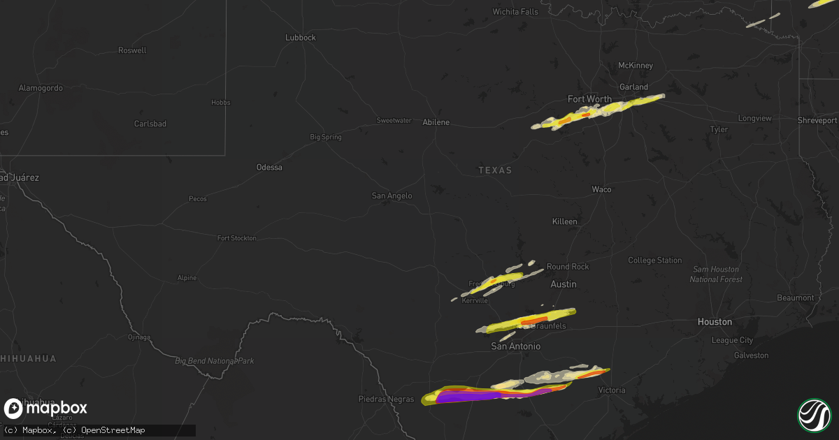
Hail Map in Texas on March 1, 2023
Get this storm
March 1 map
$229
one time, instant access
Download today. No call, no setup
Keep the $229
Bought the map and want the full workflow? Apply the entire $229 to a subscription within 7 days. None of it is wasted.
Every map, not just this one
This buys you this map. Subscription and you get every map we run, in the markets you choose from a few cities to whole states to nationwide. Plus real-time alerts the moment a storm fires.
Contact data
Name, contact info, occupancy, even credit band for addresses in the footprint. You go from where it hit to who to call.
Become the source they trust
Unlimited branding weather history reports on demand. You already have the documented answer ready for the property owner, and you are the one who showed up with it.
Property data and RoofTrace estimates
Pull up any address you have got, its value and the exact code rules for that jurisdiction, straight from One Click Code. Then RoofTrace estimates the squares, pitch, and roof value, priced the way you price.
Storm reports in Texas
Texas
| Date | Description |
|---|---|
| 03/01/20238:26 AM CST | Delayed report. Quarter size hail was reported via mping. |
| 03/01/20238:13 AM CST | Delayed report. Quarter size hail was reported via mping. |
| 03/01/20238:12 AM CST | Em reports half-dollar size hail in desoto. |
| 03/01/20238:02 AM CST | Report of quarter size hail in grand prairie. |
| 03/01/20237:55 AM CST | Delayed report. Quarter size hail was reported via mping. |
| 03/01/20237:41 AM CST | Delayed report: quarter hail in everman. |
| 03/01/20237:39 AM CST | Delayed report. Quarter size hail was reported via mping. |
| 03/01/20237:39 AM CST | Delayed report. Golf ball size hail was reported via mping. |
| 03/01/20237:36 AM CST | Quarter size hail was reported near mcalister and archbury. |
| 03/01/20237:33 AM CST | Delayed report. Quarter size hail was reported via mping. |
| 03/01/20237:32 AM CST | Delayed report. Ping pong ball size hail was reported via mping. |
| 03/01/20237:05 AM CST | Picture of half dollar sized hail |
| 03/01/20237:05 AM CST | Delayed report: picture of ping pong ball size hail |
| 03/01/20237:01 AM CST | Reports of quarter size hail in granbury. |
| 03/01/20237:00 AM CST | Delayed report. Quarter size hail reported via mping. |
| 03/01/20237:00 AM CST | Delayed report. Quarter size hail was reported via mping. |
| 03/01/20236:58 AM CST | Spotter reports quarter size hail in crowley. |
| 03/01/20236:35 AM CST | Delayed report. Quarter size hail reported via mping. |
| 03/01/20235:32 AM CST | Measured with a ruler. |
| 03/01/20235:27 AM CST | A local report indicates 1.00 inch wind near 1 SSW FREDERICKSBURG |
| 03/01/20234:56 AM CST | A local report indicates 1.00 inch wind near 9 NE INGRAM |
| 03/01/20234:04 AM CST | Report from mping: quarter |
| 03/01/20234:00 AM CST | Lots of peak to nickel hail covering the ground with pictures conriming isolated quarter sized. |
| 03/01/20233:56 AM CST | 1.5 to 1.75 inch diameter hail. Report from retired nws employee. |
| 03/01/20233:50 AM CST | A local report indicates 1.00 inch wind near 7 NNE NEW BRAUNFELS |
| 03/01/20233:49 AM CST | A local report indicates 1.00 inch wind near 8 NNE NEW BRAUNFELS |
| 03/01/20233:39 AM CST | A local report indicates 1.50 inch wind near 7 WNW NEW BRAUNFELS |
| 03/01/20233:35 AM CST | Hail up to golf ball size. |
| 03/01/20233:29 AM CST | Mping. |
| 03/01/20233:27 AM CST | Report from mping: golf ball |
| 03/01/20233:24 AM CST | A local report indicates 1.00 inch wind near 2 NNE BULVERDE |
| 03/01/20233:22 AM CST | A local report indicates 1.00 inch wind near 1 SW TIMBERWOOD PARK |
| 03/01/20233:20 AM CST | A local report indicates 1.00 inch wind near 6 NNW GARDEN RIDGE |
| 03/01/20233:20 AM CST | Hail duration of 2 to 3 minutes. |
| 03/01/20233:12 AM CST | Very widespread. |
| 03/01/20233:05 AM CST | Hail up to quarter size. |
| 03/01/20232:46 AM CST | Report from mping: quarter |
| 03/01/20232:09 AM CST | Report from mping: quarter |
| 03/01/20231:30 AM CST | A local report indicates 1.00 inch wind near 4 WNW THOMASTON |
| 03/01/20231:05 AM CST | A local report indicates 1.25 inch wind near 5 SW CUERO |
| 03/01/202312:15 AM CST | A local report indicates 1.75 inch wind near 3 SW COY CITY |
| 03/01/202312:00 AM CST | A local report indicates 1.00 inch wind near CAMPBELLTON |
| 02/28/202311:15 PM CST | Social media picture of estimated 3 inch hail. |
| 02/28/202310:42 PM CST | A local report indicates 2.00 inch wind near DILLEY |
| 02/28/202310:41 PM CST | Reported softball sized hail off of hwy 117 west of dilley. Hail came through roofs of mobile homes and truck windshields. |
All States Impacted by Hail Map on March 1, 2023
Cities Impacted by Hail Map on March 1, 2023
- Granbury, TX
- Tolar, TX
- Bluff Dale, TX
- Cresson, TX
- Godley, TX
- Joshua, TX
- Crowley, TX
- Burleson, TX
- Fort Worth, TX
- Lancaster, TX
- Dallas, TX
- Mansfield, TX
- Arlington, TX
- Grand Prairie, TX
- Cedar Hill, TX
- Duncanville, TX
- Desoto, TX
- Hutchins, TX
- Balch Springs, TX
- Mesquite, TX
- Seagoville, TX
- Forney, TX
- Terrell, TX
- Lipan, TX
- Stephenville, TX
- Weatherford, TX
- Sunnyvale, TX
- Midlothian, TX
- Kennedale, TX
- Venus, TX
- Robards, KY
- Owensboro, KY
- Henderson, KY
- Slaughters, KY
- Sebree, KY
- Calhoun, KY
- Rockport, IN
- Leopold, IN
- Branchville, IN
- Leavenworth, IN
- English, IN
- Battletown, KY
- Sulphur, IN
- Milltown, IN
- Norman, AR
- Mount Ida, AR
- Story, AR
- New Salisbury, IN
- Palmyra, IN
- Greenville, IN
- Pekin, IN
- Borden, IN
- Floyds Knobs, IN
- Memphis, IN
- Sellersburg, IN
- Charlestown, IN
- Royal, AR
- Hot Springs National Park, AR
- Hickory Valley, TN
- Bolivar, TN
- Byhalia, MS
- Red Banks, MS
- Holly Springs, MS
- Mountain Pine, AR
- Saulsbury, TN
- Hot Springs Village, AR
- Murfreesboro, AR
- Nashville, AR
- Delight, AR
- Lonsdale, AR
- Benton, AR
- Okolona, AR
- Arkadelphia, AR
- Bryant, AR
- Bauxite, AR
- Alexander, AR
- Vevay, IN
- Ghent, KY
- Warsaw, KY
- Sanders, KY
- Sparta, KY
- Glencoe, KY
- England, AR
- Humnoke, AR
- Stuttgart, AR
- Carlisle, AR
- Ulm, AR
- Humphrey, AR
- Wabbaseka, AR
- Roe, AR
- De Valls Bluff, AR
- Grapevine, AR
- Pine Bluff, AR
- Rison, AR
- Holly Grove, AR
- Clarendon, AR
- Casscoe, AR
- Glen, MS
- Burnsville, MS
- Iuka, MS
- Star City, AR
- Yorktown, AR
- Marvell, AR
- Aubrey, AR
- Poplar Grove, AR
- Lexa, AR
- Marianna, AR
- Grady, AR
- Gould, AR
- Dumas, AR
- Gillett, AR
- Helena, AR
- West Helena, AR
- Watson, AR
- Burlington, KY
- Depauw, IN
- Corydon, IN
- Cannelton, IN
- Hazen, AR
- Jeffersonville, IN
- Prospect, KY
- Goshen, KY
- Gurdon, AR
- Sparkman, AR
- Lamar, MS
- Olive Branch, MS
- Moscow, TN
- Madison, IN
- Dupont, IN
- Commiskey, IN
- Rienzi, MS
- Dundee, MS
- Marysville, IN
- Nabb, IN
- Milton, KY
- Lexington, IN
- Bedford, KY
- Underwood, IN
- Hanover, IN
- Bennington, IN
- Florence, IN
- Patriot, IN
- Philpot, KY
- Maceo, KY
- Lewisport, KY
- Dixon, KY
- Hawesville, KY
- Tell City, IN
- Derby, IN
- Otisco, IN
- Georgetown, IN
- Ramsey, IN
- Henryville, IN
- New Washington, IN
- Scott, AR
- Lonoke, AR
- Keo, AR
- Crandall, IN
- Mena, AR
- Little Rock, AR
- Mabelvale, AR
- Traskwood, AR
- Caddo Gap, AR
- Carthage, AR
- Haworth, OK
- Winthrop, AR
- Foreman, AR
- Donaldson, AR
- Sheridan, AR
- Malvern, AR
- Sledge, MS
- Avery, TX
- Tunica, MS
- Cincinnati, OH
- Tichnor, AR
- Snow Lake, AR
- Rosedale, MS
- Gunnison, MS
- Shelby, MS
- Mound Bayou, MS
- Crystal City, TX
- Batesville, TX
- Big Wells, TX
- Dilley, TX
- Pearsall, TX
- Carrizo Springs, TX
- Charlotte, TX
- Jourdanton, TX
- Pleasanton, TX
- Christine, TX
- Campbellton, TX
- Falls City, TX
- Three Rivers, TX
- Karnes City, TX
- Kenedy, TX
- Runge, TX
- Nordheim, TX
- Yorktown, TX
- Cuero, TX
- Yoakum, TX
- Moore, TX
- Vina, AL
- Golden, MS
- Red Bay, AL
- Fulton, MS
- Tremont, MS
- Sarah, MS
- Como, MS
- Crenshaw, MS
- Double Springs, AL
- Grand Junction, TN
- Haleyville, AL
- Tanner, AL
- Coahoma, MS
- Crocketts Bluff, AR
- Decatur, AL
- Trinity, AL
- Hillsboro, AL
- Madison, AL
- Athens, AL
- Bear Creek, AL
- Hensley, AR
- Kingsland, AR
- New Market, AL
- Helotes, TX
- Pipe Creek, TX
- Mico, TX
- San Antonio, TX
- Boerne, TX
- Bulverde, TX
- New Braunfels, TX
- Spring Branch, TX
- Canyon Lake, TX
- San Marcos, TX
- Martindale, TX
- Maxwell, TX
- Lockhart, TX
- Dale, TX
- Kerrville, TX
- Fredericksburg, TX
- Johnson City, TX
- Round Mountain, TX
- Westhoff, TX
- Hobson, TX
- Carrollton, KY
- Addison, AL
- Bandera, TX
- Ecleto, TX
- Floresville, TX
- Poth, TX
- Gillett, TX
- Houston, AL
- Arley, AL
- Hunt, TX
- Ingram, TX
- Spicewood, TX
- Marble Falls, TX
- Willow City, TX
- Llano, TX
- Horseshoe Bay, TX
- Indianola, MS
- Shaw, MS
- Doddsville, MS
- Sunflower, MS
- Kyle, TX
- Wimberley, TX
- Red Rock, TX
- Leander, TX
- Seguin, TX
- Kingsbury, TX
- Comfort, TX
- Mountain Home, TX
- Harper, TX
- Eddyville, KY
- Fredonia, KY
- Troy, IN
- Evanston, IN


