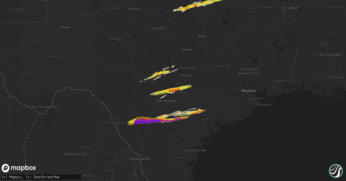
Hail Map on March 1, 2023
Get this storm
March 1 map
$229
one time, instant access
Download today. No call, no setup
Keep the $229
Bought the map and want the full workflow? Apply the entire $229 to a subscription within 7 days. None of it is wasted.
Every map, not just this one
This buys you this map. Subscription and you get every map we run, in the markets you choose from a few cities to whole states to nationwide. Plus real-time alerts the moment a storm fires.
Contact data
Name, contact info, occupancy, even credit band for addresses in the footprint. You go from where it hit to who to call.
Become the source they trust
Unlimited branding weather history reports on demand. You already have the documented answer ready for the property owner, and you are the one who showed up with it.
Property data and RoofTrace estimates
Pull up any address you have got, its value and the exact code rules for that jurisdiction, straight from One Click Code. Then RoofTrace estimates the squares, pitch, and roof value, priced the way you price.
States Impacted by Hail Map on March 1, 2023
Storm reports
Tennessee
| Date | Description |
|---|---|
| 03/01/20231:16 AM CST | Trees down in prentice cooper state forest. A swath of trees came down in this area of about 100 yards wide and 500 yards long. Time estimated by radar. |
| 03/01/20231:11 AM CST | A few trees down along mullins cove road. Time and location estimated by radar. |
| 03/01/202312:53 AM CST | Homes damaged... Roof blown off a barn... Trees and power lines down. Possible tornado. Public report on cranfield road. |
| 03/01/202312:52 AM CST | Tree down at cranfield road and grasshopper road. From social media picture. Time estimated by radar. |
| 03/01/202312:50 AM CST | Trees and power lines down near intersection of grasshopper road and birchwood pike... Highway 605. Also minor building damage. Other damage on dolly pond road. Time es |
| 03/01/202312:48 AM CST | Large tree down across road. |
| 03/01/202312:16 AM CST | Corrects previous tstm wnd dmg report from 5 wsw signal mountain. Trees down in prentice cooper state forest. A swath of trees came down in this area of about 100 yards |
| 03/01/202312:11 AM CST | Corrects previous tstm wnd dmg report from 5 ne haletown |
| 03/01/202312:11 AM CST | Multiple photos of a roof blown off a house with pieces of it in the woods over 100 yards from the structure. Possible tornado based on indications from radar data. |
Texas
| Date | Description |
|---|---|
| 03/01/20238:26 AM CST | Delayed report. Quarter size hail was reported via mping. |
| 03/01/20238:13 AM CST | Delayed report. Quarter size hail was reported via mping. |
| 03/01/20238:12 AM CST | Em reports half-dollar size hail in desoto. |
| 03/01/20238:02 AM CST | Report of quarter size hail in grand prairie. |
| 03/01/20237:55 AM CST | Delayed report. Quarter size hail was reported via mping. |
| 03/01/20237:41 AM CST | Delayed report: quarter hail in everman. |
| 03/01/20237:39 AM CST | Delayed report. Quarter size hail was reported via mping. |
| 03/01/20237:39 AM CST | Delayed report. Golf ball size hail was reported via mping. |
| 03/01/20237:36 AM CST | Quarter size hail was reported near mcalister and archbury. |
| 03/01/20237:33 AM CST | Delayed report. Quarter size hail was reported via mping. |
| 03/01/20237:32 AM CST | Delayed report. Ping pong ball size hail was reported via mping. |
| 03/01/20237:05 AM CST | Delayed report: picture of ping pong ball size hail |
| 03/01/20237:05 AM CST | Picture of half dollar sized hail |
| 03/01/20237:01 AM CST | Reports of quarter size hail in granbury. |
| 03/01/20237:00 AM CST | Delayed report. Quarter size hail reported via mping. |
| 03/01/20237:00 AM CST | Delayed report. Quarter size hail was reported via mping. |
| 03/01/20236:58 AM CST | Spotter reports quarter size hail in crowley. |
| 03/01/20236:35 AM CST | Delayed report. Quarter size hail reported via mping. |
| 03/01/20235:32 AM CST | Measured with a ruler. |
| 03/01/20235:27 AM CST | A local report indicates 1.00 inch wind near 1 SSW FREDERICKSBURG |
| 03/01/20234:56 AM CST | A local report indicates 1.00 inch wind near 9 NE INGRAM |
| 03/01/20234:04 AM CST | Report from mping: quarter |
| 03/01/20234:00 AM CST | Lots of peak to nickel hail covering the ground with pictures conriming isolated quarter sized. |
| 03/01/20233:56 AM CST | 1.5 to 1.75 inch diameter hail. Report from retired nws employee. |
| 03/01/20233:50 AM CST | A local report indicates 1.00 inch wind near 7 NNE NEW BRAUNFELS |
| 03/01/20233:49 AM CST | A local report indicates 1.00 inch wind near 8 NNE NEW BRAUNFELS |
| 03/01/20233:39 AM CST | A local report indicates 1.50 inch wind near 7 WNW NEW BRAUNFELS |
| 03/01/20233:35 AM CST | Hail up to golf ball size. |
| 03/01/20233:29 AM CST | Mping. |
| 03/01/20233:27 AM CST | Report from mping: golf ball |
| 03/01/20233:24 AM CST | A local report indicates 1.00 inch wind near 2 NNE BULVERDE |
| 03/01/20233:22 AM CST | A local report indicates 1.00 inch wind near 1 SW TIMBERWOOD PARK |
| 03/01/20233:20 AM CST | Hail duration of 2 to 3 minutes. |
| 03/01/20233:20 AM CST | A local report indicates 1.00 inch wind near 6 NNW GARDEN RIDGE |
| 03/01/20233:12 AM CST | Very widespread. |
| 03/01/20233:05 AM CST | Hail up to quarter size. |
| 03/01/20232:46 AM CST | Report from mping: quarter |
| 03/01/20232:09 AM CST | Report from mping: quarter |
| 03/01/20231:30 AM CST | A local report indicates 1.00 inch wind near 4 WNW THOMASTON |
| 03/01/20231:05 AM CST | A local report indicates 1.25 inch wind near 5 SW CUERO |
| 03/01/202312:15 AM CST | A local report indicates 1.75 inch wind near 3 SW COY CITY |
| 03/01/202312:00 AM CST | A local report indicates 1.00 inch wind near CAMPBELLTON |
| 02/28/202311:15 PM CST | Social media picture of estimated 3 inch hail. |
| 02/28/202310:42 PM CST | A local report indicates 2.00 inch wind near DILLEY |
| 02/28/202310:41 PM CST | Reported softball sized hail off of hwy 117 west of dilley. Hail came through roofs of mobile homes and truck windshields. |
Mississippi
| Date | Description |
|---|---|
| 02/28/20239:45 PM CST | Large tree downed in road. |
| 02/28/20239:45 PM CST | Large hail reported. |
| 02/28/20239:38 PM CST | A swath of large hail fell across west-central bolivar co. The largest reported was 3 inches. Several other reports in the swath ranged from golf ball to baseball size. |
| 02/28/20239:30 PM CST | Corrects previous tstm wnd dmg report from gunnison. Large tree downed in road. |
| 02/28/20239:26 PM CST | Corrects previous hail report from gunnison. Large hail reported. |
| 02/28/20237:50 PM CST | Quarter size hail. |
| 02/28/20237:50 PM CST | Partial collapse to a gas station canopy. |
| 02/28/20236:19 PM CST | Quarter size hail fell in mt. Pleasant. |
Arkansas
| Date | Description |
|---|---|
| 03/01/20235:47 PM CST | Coop observer sent pictures of hail of at least half-dollar size to the office. |
| 02/28/202310:19 PM CST | ** this is a delayed report! ** from an nws storm damage survey... 85 mph thunderstorm winds produced damage in a swath across the city of rison wednesday evening. Time |
| 02/28/202310:07 PM CST | Minor roof damage and trees down along hwy 167... South of thornton. |
| 02/28/20238:24 PM CST | Report received through social media. |
| 02/28/20238:11 PM CST | Carport also reported to be blown over. Report received through social media. |
| 02/28/20238:10 PM CST | Numerous large trees blown down sw of rison. |
| 02/28/20238:08 PM CST | Metal outbuilding destroyed. |
| 02/28/20237:55 PM CST | Reported by emergency management. |
| 02/28/20237:53 PM CST | A local report indicates 1.50 inch wind near 3 W STUTTGART |
| 02/28/20236:56 PM CST | Report from mping: quarter |
| 02/28/20236:55 PM CST | A member of the broadcast media shared a picture of hail 1.5 inches in diameter from benton. |
| 02/28/20236:30 PM CST | Amateur radio reported 1 inch hail on cedar glades rd on the northwest side of hot springs. |
California
| Date | Description |
|---|---|
| 03/01/20234:15 PM CST | Line of heavy showers moving through orange county. Large mature pine tree knocked down near intersection of macarthur and main street. Diameter of tree estimated 3 fee |
| 03/01/20232:50 PM CST | *** 1 inj *** social media video of wind damage to roof shingles... A canopy lifted onto a roof... And a large tree uprooted. One person possibly injured. Inconclusive |
| 03/01/20232:45 PM CST | Social media video of wind damage to roofing material and a stop sign was blown over. Inconclusive whether this was a small tornado. |
| 03/01/20232:25 PM CST | 1-inch tree limbs broken. Shingles blown off. |
Kentucky
| Date | Description |
|---|---|
| 03/01/20235:20 PM CST | Relayed by wpsd. |
| 03/01/20234:50 PM CST | Report from mping: quarter |
| 03/01/20234:50 PM CST | Semi blown off the road on highway 81. Power line down. |
| 03/01/20234:50 PM CST | West daviess county at rome. Large pine tree and weeping willow blown over. Wind was so strong we couldnt see the road which is about 100 yards away. Barn blown down to |
| 03/01/20234:50 PM CST | Two garages collapsed along wayne bridges road west of hwy 81. |
| 02/28/20236:15 PM CST | Report from mping of quarter hail. Time estimated from radar. |
| 02/28/20236:05 PM CST | A local report indicates 1.00 inch wind near MILTON |
Indiana
| Date | Description |
|---|---|
| 03/01/20235:58 PM CST | A local report indicates 1.00 inch wind near 1 S HANOVER |
| 03/01/20235:55 PM CST | Broadcast media relayed picture of hail measured against a ruler. Time estimated from radar. |
| 03/01/20235:54 PM CST | A local report indicates 1.75 inch wind near 2 NNE CENTRAL BARREN |
| 03/01/20235:54 PM CST | A local report indicates 1.75 inch wind near 1 SSW BRADFORD |
| 03/01/20235:25 PM CST | 1.25 to 1.50 inch hail was reported near beechwood. In a picture the hail was clearly larger than a quarter. |
| 03/01/20235:09 PM CST | A local report indicates 1.00 inch wind near 1 NNW TELL CITY |
| 02/28/20236:21 PM CST | A local report indicates 1.00 inch wind near 1 ENE OTISCO |
| 02/28/20236:16 PM CST | A local report indicates 1.00 inch wind near MEMPHIS |
| 02/28/20236:15 PM CST | A local report indicates 1.00 inch wind near VEVAY |
| 02/28/20236:00 PM CST | A local report indicates 1.00 inch wind near GREENVILLE |
| 02/28/20236:00 PM CST | A local report indicates 1.75 inch wind near HANOVER |
Alabama
| Date | Description |
|---|---|
| 03/01/20239:54 AM CST | Trees blocking cr 56 near shottsville community church. Possible tornado. |
| 02/28/202311:15 PM CST | Tree down blocking roadway along county road 107 in skyline. Time estimated by radar. |
| 02/28/202310:38 PM CST | Bristol ridge subdivision in new market has roofs... Front porches... And a truck was thrown. Time estimated by radar. |
| 02/28/202310:33 PM CST | Power poles snapped near hwy 231 and walker ln - possibly due to a circulation. Time estimated by radar. |
| 02/28/202310:32 PM CST | While this tornado was very narrow and very short-lived... It did manage to cause a significant amount of damage to structures along short track dr. In new market. The |
| 02/28/202310:11 PM CST | Multiple trees down on hwy 187 near mile marker 7. Possible tornado. |
| 02/28/20239:56 PM CST | Several trees and power lines down east of shotsville. A few roadways are impassable due to downed trees. Radar depicted a tds. |
| 02/28/20239:55 PM CST | Signs blown down along with other debris in the area. Corresponds to the intense circulation. |
| 02/28/20239:54 PM CST | Corrects previous tstm wnd dmg report from shottsville. Trees blocking cr 56 near shottsville community church. Possible tornado. |
| 02/28/20239:53 PM CST | Measured at pryor field. |
| 02/28/20239:53 PM CST | A local report indicates 59 MPH wind near DCU PRYOR FIELD |
Cities Impacted by Hail Map on March 1, 2023
- Granbury, TX
- Tolar, TX
- Bluff Dale, TX
- Cresson, TX
- Godley, TX
- Joshua, TX
- Crowley, TX
- Burleson, TX
- Fort Worth, TX
- Lancaster, TX
- Dallas, TX
- Mansfield, TX
- Arlington, TX
- Grand Prairie, TX
- Cedar Hill, TX
- Duncanville, TX
- Desoto, TX
- Hutchins, TX
- Balch Springs, TX
- Mesquite, TX
- Seagoville, TX
- Forney, TX
- Terrell, TX
- Lipan, TX
- Stephenville, TX
- Weatherford, TX
- Sunnyvale, TX
- Midlothian, TX
- Kennedale, TX
- Venus, TX
- Robards, KY
- Owensboro, KY
- Henderson, KY
- Slaughters, KY
- Sebree, KY
- Calhoun, KY
- Rockport, IN
- Leopold, IN
- Branchville, IN
- Leavenworth, IN
- English, IN
- Battletown, KY
- Sulphur, IN
- Milltown, IN
- Norman, AR
- Mount Ida, AR
- Story, AR
- New Salisbury, IN
- Palmyra, IN
- Greenville, IN
- Pekin, IN
- Borden, IN
- Floyds Knobs, IN
- Memphis, IN
- Sellersburg, IN
- Charlestown, IN
- Royal, AR
- Hot Springs National Park, AR
- Hickory Valley, TN
- Bolivar, TN
- Byhalia, MS
- Red Banks, MS
- Holly Springs, MS
- Mountain Pine, AR
- Saulsbury, TN
- Hot Springs Village, AR
- Murfreesboro, AR
- Nashville, AR
- Delight, AR
- Lonsdale, AR
- Benton, AR
- Okolona, AR
- Arkadelphia, AR
- Bryant, AR
- Bauxite, AR
- Alexander, AR
- Vevay, IN
- Ghent, KY
- Warsaw, KY
- Sanders, KY
- Sparta, KY
- Glencoe, KY
- England, AR
- Humnoke, AR
- Stuttgart, AR
- Carlisle, AR
- Ulm, AR
- Humphrey, AR
- Wabbaseka, AR
- Roe, AR
- De Valls Bluff, AR
- Grapevine, AR
- Pine Bluff, AR
- Rison, AR
- Holly Grove, AR
- Clarendon, AR
- Casscoe, AR
- Glen, MS
- Burnsville, MS
- Iuka, MS
- Star City, AR
- Yorktown, AR
- Marvell, AR
- Aubrey, AR
- Poplar Grove, AR
- Lexa, AR
- Marianna, AR
- Grady, AR
- Gould, AR
- Dumas, AR
- Gillett, AR
- Helena, AR
- West Helena, AR
- Watson, AR
- Burlington, KY
- Depauw, IN
- Corydon, IN
- Cannelton, IN
- Hazen, AR
- Jeffersonville, IN
- Prospect, KY
- Goshen, KY
- Gurdon, AR
- Sparkman, AR
- Lamar, MS
- Olive Branch, MS
- Moscow, TN
- Madison, IN
- Dupont, IN
- Commiskey, IN
- Rienzi, MS
- Dundee, MS
- Marysville, IN
- Nabb, IN
- Milton, KY
- Lexington, IN
- Bedford, KY
- Underwood, IN
- Hanover, IN
- Bennington, IN
- Florence, IN
- Patriot, IN
- Philpot, KY
- Maceo, KY
- Lewisport, KY
- Dixon, KY
- Hawesville, KY
- Tell City, IN
- Derby, IN
- Otisco, IN
- Georgetown, IN
- Ramsey, IN
- Henryville, IN
- New Washington, IN
- Scott, AR
- Lonoke, AR
- Keo, AR
- Crandall, IN
- Mena, AR
- Little Rock, AR
- Mabelvale, AR
- Traskwood, AR
- Caddo Gap, AR
- Carthage, AR
- Haworth, OK
- Winthrop, AR
- Foreman, AR
- Donaldson, AR
- Sheridan, AR
- Malvern, AR
- Sledge, MS
- Avery, TX
- Tunica, MS
- Cincinnati, OH
- Tichnor, AR
- Snow Lake, AR
- Rosedale, MS
- Gunnison, MS
- Shelby, MS
- Mound Bayou, MS
- Crystal City, TX
- Batesville, TX
- Big Wells, TX
- Dilley, TX
- Pearsall, TX
- Carrizo Springs, TX
- Charlotte, TX
- Jourdanton, TX
- Pleasanton, TX
- Christine, TX
- Campbellton, TX
- Falls City, TX
- Three Rivers, TX
- Karnes City, TX
- Kenedy, TX
- Runge, TX
- Nordheim, TX
- Yorktown, TX
- Cuero, TX
- Yoakum, TX
- Moore, TX
- Vina, AL
- Golden, MS
- Red Bay, AL
- Fulton, MS
- Tremont, MS
- Sarah, MS
- Como, MS
- Crenshaw, MS
- Double Springs, AL
- Grand Junction, TN
- Haleyville, AL
- Tanner, AL
- Coahoma, MS
- Crocketts Bluff, AR
- Decatur, AL
- Trinity, AL
- Hillsboro, AL
- Madison, AL
- Athens, AL
- Bear Creek, AL
- Hensley, AR
- Kingsland, AR
- New Market, AL
- Helotes, TX
- Pipe Creek, TX
- Mico, TX
- San Antonio, TX
- Boerne, TX
- Bulverde, TX
- New Braunfels, TX
- Spring Branch, TX
- Canyon Lake, TX
- San Marcos, TX
- Martindale, TX
- Maxwell, TX
- Lockhart, TX
- Dale, TX
- Kerrville, TX
- Fredericksburg, TX
- Johnson City, TX
- Round Mountain, TX
- Westhoff, TX
- Hobson, TX
- Carrollton, KY
- Addison, AL
- Bandera, TX
- Ecleto, TX
- Floresville, TX
- Poth, TX
- Gillett, TX
- Houston, AL
- Arley, AL
- Hunt, TX
- Ingram, TX
- Spicewood, TX
- Marble Falls, TX
- Willow City, TX
- Llano, TX
- Horseshoe Bay, TX
- Indianola, MS
- Shaw, MS
- Doddsville, MS
- Sunflower, MS
- Kyle, TX
- Wimberley, TX
- Red Rock, TX
- Leander, TX
- Seguin, TX
- Kingsbury, TX
- Comfort, TX
- Mountain Home, TX
- Harper, TX
- Eddyville, KY
- Fredonia, KY
- Troy, IN
- Evanston, IN