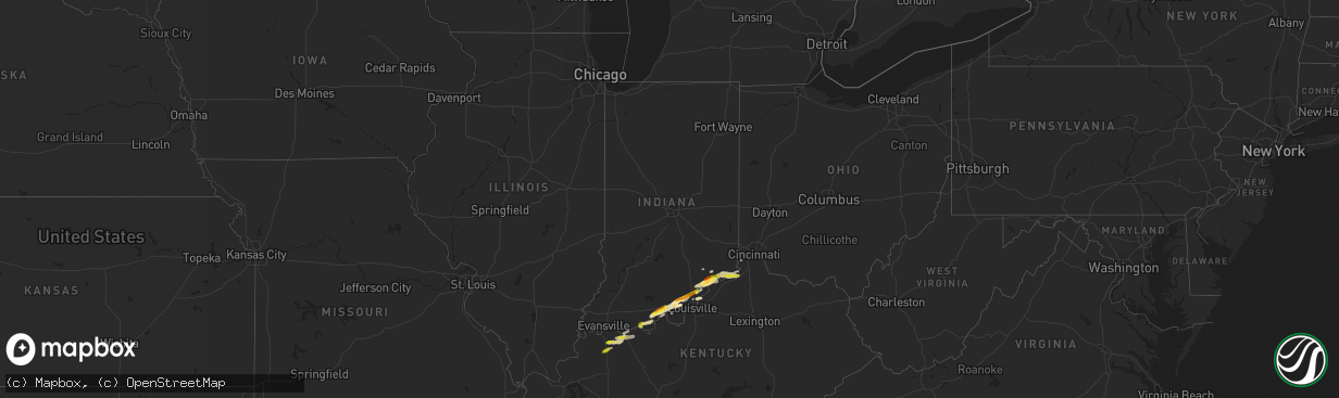
Hail Map in Indiana on March 1, 2023
The weather event in Indiana on March 1, 2023 includes Hail, Tornado, and Wind maps. 9 states and 277 cities were impacted and suffered possible damage. The total estimated number of properties impacted is 14,566.
Want more than just the map?
Turn this storm into a full workflow.
- Owner + property data so you know who to knock
- OnDemand branded weather history reports to win the "did we even have hail?" argument
- RoofTrace estimate so reps stop guessing numbers at the door
Bought this map? Upgrade within 7 days and we'll credit the $230. (10-15 min setup call)
Hail
Tornado
Wind
14,566
Estimated number of impacted properties by a 1.00" hail or larger553
Estimated number of impacted properties by a 1.75" hail or larger0
Estimated number of impacted properties by a 2.50" hail or largerStorm reports in Indiana
Indiana
| Date | Description |
|---|---|
| 03/01/20235:58 PM CST | A local report indicates 1.00 inch wind near 1 S HANOVER |
| 03/01/20235:55 PM CST | Broadcast media relayed picture of hail measured against a ruler. Time estimated from radar. |
| 03/01/20235:54 PM CST | A local report indicates 1.75 inch wind near 2 NNE CENTRAL BARREN |
| 03/01/20235:54 PM CST | A local report indicates 1.75 inch wind near 1 SSW BRADFORD |
| 03/01/20235:25 PM CST | 1.25 to 1.50 inch hail was reported near beechwood. In a picture the hail was clearly larger than a quarter. |
| 03/01/20235:09 PM CST | A local report indicates 1.00 inch wind near 1 NNW TELL CITY |
| 02/28/20236:21 PM CST | A local report indicates 1.00 inch wind near 1 ENE OTISCO |
| 02/28/20236:16 PM CST | A local report indicates 1.00 inch wind near MEMPHIS |
| 02/28/20236:15 PM CST | A local report indicates 1.00 inch wind near VEVAY |
| 02/28/20236:00 PM CST | A local report indicates 1.00 inch wind near GREENVILLE |
| 02/28/20236:00 PM CST | A local report indicates 1.75 inch wind near HANOVER |
All States Impacted by Hail Map on March 1, 2023
Cities Impacted by Hail Map on March 1, 2023
- Granbury, TX
- Tolar, TX
- Bluff Dale, TX
- Cresson, TX
- Godley, TX
- Joshua, TX
- Crowley, TX
- Burleson, TX
- Fort Worth, TX
- Lancaster, TX
- Dallas, TX
- Mansfield, TX
- Arlington, TX
- Grand Prairie, TX
- Cedar Hill, TX
- Duncanville, TX
- Desoto, TX
- Hutchins, TX
- Balch Springs, TX
- Mesquite, TX
- Seagoville, TX
- Forney, TX
- Terrell, TX
- Lipan, TX
- Stephenville, TX
- Weatherford, TX
- Sunnyvale, TX
- Midlothian, TX
- Kennedale, TX
- Venus, TX
- Robards, KY
- Owensboro, KY
- Henderson, KY
- Slaughters, KY
- Sebree, KY
- Calhoun, KY
- Rockport, IN
- Leopold, IN
- Branchville, IN
- Leavenworth, IN
- English, IN
- Battletown, KY
- Sulphur, IN
- Milltown, IN
- Norman, AR
- Mount Ida, AR
- Story, AR
- New Salisbury, IN
- Palmyra, IN
- Greenville, IN
- Pekin, IN
- Borden, IN
- Floyds Knobs, IN
- Memphis, IN
- Sellersburg, IN
- Charlestown, IN
- Royal, AR
- Hot Springs National Park, AR
- Hickory Valley, TN
- Bolivar, TN
- Byhalia, MS
- Red Banks, MS
- Holly Springs, MS
- Mountain Pine, AR
- Saulsbury, TN
- Hot Springs Village, AR
- Murfreesboro, AR
- Nashville, AR
- Delight, AR
- Lonsdale, AR
- Benton, AR
- Okolona, AR
- Arkadelphia, AR
- Bryant, AR
- Bauxite, AR
- Alexander, AR
- Vevay, IN
- Ghent, KY
- Warsaw, KY
- Sanders, KY
- Sparta, KY
- Glencoe, KY
- England, AR
- Humnoke, AR
- Stuttgart, AR
- Carlisle, AR
- Ulm, AR
- Humphrey, AR
- Wabbaseka, AR
- Roe, AR
- De Valls Bluff, AR
- Grapevine, AR
- Pine Bluff, AR
- Rison, AR
- Holly Grove, AR
- Clarendon, AR
- Casscoe, AR
- Glen, MS
- Burnsville, MS
- Iuka, MS
- Star City, AR
- Yorktown, AR
- Marvell, AR
- Aubrey, AR
- Poplar Grove, AR
- Lexa, AR
- Marianna, AR
- Grady, AR
- Gould, AR
- Dumas, AR
- Gillett, AR
- Helena, AR
- West Helena, AR
- Watson, AR
- Burlington, KY
- Depauw, IN
- Corydon, IN
- Cannelton, IN
- Hazen, AR
- Jeffersonville, IN
- Prospect, KY
- Goshen, KY
- Gurdon, AR
- Sparkman, AR
- Lamar, MS
- Olive Branch, MS
- Moscow, TN
- Madison, IN
- Dupont, IN
- Commiskey, IN
- Rienzi, MS
- Dundee, MS
- Marysville, IN
- Nabb, IN
- Milton, KY
- Lexington, IN
- Bedford, KY
- Underwood, IN
- Hanover, IN
- Bennington, IN
- Florence, IN
- Patriot, IN
- Philpot, KY
- Maceo, KY
- Lewisport, KY
- Dixon, KY
- Hawesville, KY
- Tell City, IN
- Derby, IN
- Otisco, IN
- Georgetown, IN
- Ramsey, IN
- Henryville, IN
- New Washington, IN
- Scott, AR
- Lonoke, AR
- Keo, AR
- Crandall, IN
- Mena, AR
- Little Rock, AR
- Mabelvale, AR
- Traskwood, AR
- Caddo Gap, AR
- Carthage, AR
- Haworth, OK
- Winthrop, AR
- Foreman, AR
- Donaldson, AR
- Sheridan, AR
- Malvern, AR
- Sledge, MS
- Avery, TX
- Tunica, MS
- Cincinnati, OH
- Tichnor, AR
- Snow Lake, AR
- Rosedale, MS
- Gunnison, MS
- Shelby, MS
- Mound Bayou, MS
- Crystal City, TX
- Batesville, TX
- Big Wells, TX
- Dilley, TX
- Pearsall, TX
- Carrizo Springs, TX
- Charlotte, TX
- Jourdanton, TX
- Pleasanton, TX
- Christine, TX
- Campbellton, TX
- Falls City, TX
- Three Rivers, TX
- Karnes City, TX
- Kenedy, TX
- Runge, TX
- Nordheim, TX
- Yorktown, TX
- Cuero, TX
- Yoakum, TX
- Moore, TX
- Vina, AL
- Golden, MS
- Red Bay, AL
- Fulton, MS
- Tremont, MS
- Sarah, MS
- Como, MS
- Crenshaw, MS
- Double Springs, AL
- Grand Junction, TN
- Haleyville, AL
- Tanner, AL
- Coahoma, MS
- Crocketts Bluff, AR
- Decatur, AL
- Trinity, AL
- Hillsboro, AL
- Madison, AL
- Athens, AL
- Bear Creek, AL
- Hensley, AR
- Kingsland, AR
- New Market, AL
- Helotes, TX
- Pipe Creek, TX
- Mico, TX
- San Antonio, TX
- Boerne, TX
- Bulverde, TX
- New Braunfels, TX
- Spring Branch, TX
- Canyon Lake, TX
- San Marcos, TX
- Martindale, TX
- Maxwell, TX
- Lockhart, TX
- Dale, TX
- Kerrville, TX
- Fredericksburg, TX
- Johnson City, TX
- Round Mountain, TX
- Westhoff, TX
- Hobson, TX
- Carrollton, KY
- Addison, AL
- Bandera, TX
- Ecleto, TX
- Floresville, TX
- Poth, TX
- Gillett, TX
- Houston, AL
- Arley, AL
- Hunt, TX
- Ingram, TX
- Spicewood, TX
- Marble Falls, TX
- Willow City, TX
- Llano, TX
- Horseshoe Bay, TX
- Indianola, MS
- Shaw, MS
- Doddsville, MS
- Sunflower, MS
- Kyle, TX
- Wimberley, TX
- Red Rock, TX
- Leander, TX
- Seguin, TX
- Kingsbury, TX
- Comfort, TX
- Mountain Home, TX
- Harper, TX
- Eddyville, KY
- Fredonia, KY
- Troy, IN
- Evanston, IN


