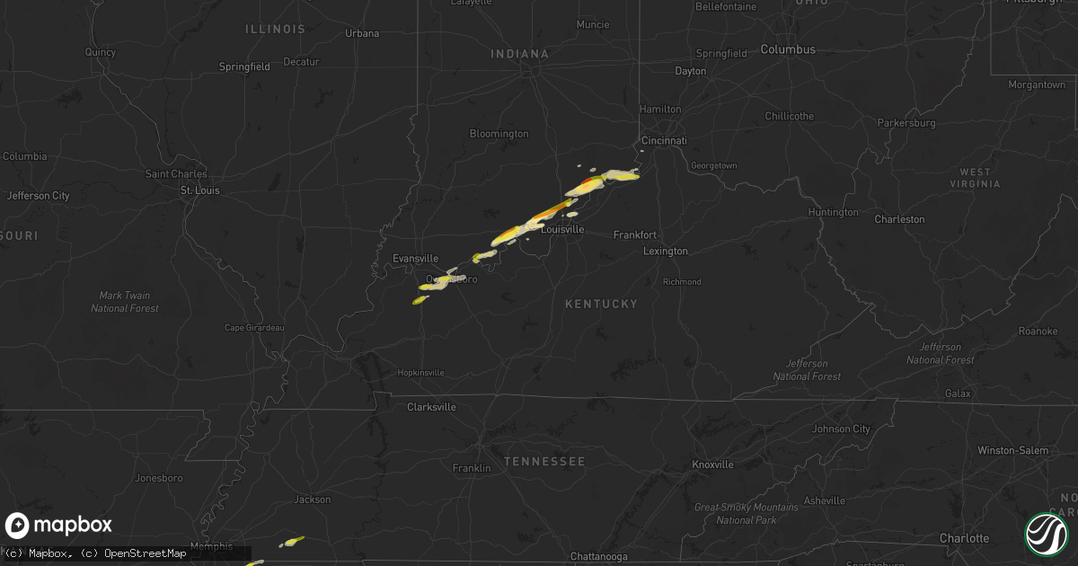
Hail Map in Kentucky on March 1, 2023
Get this storm
March 1 map
$229
one time, instant access
Download today. No call, no setup
Keep the $229
Bought the map and want the full workflow? Apply the entire $229 to a subscription within 7 days. None of it is wasted.
Every map, not just this one
This buys you this map. Subscription and you get every map we run, in the markets you choose from a few cities to whole states to nationwide. Plus real-time alerts the moment a storm fires.
Contact data
Name, contact info, occupancy, even credit band for addresses in the footprint. You go from where it hit to who to call.
Become the source they trust
Unlimited branding weather history reports on demand. You already have the documented answer ready for the property owner, and you are the one who showed up with it.
Property data and RoofTrace estimates
Pull up any address you have got, its value and the exact code rules for that jurisdiction, straight from One Click Code. Then RoofTrace estimates the squares, pitch, and roof value, priced the way you price.
Storm reports in Kentucky
Kentucky
| Date | Description |
|---|---|
| 03/01/20235:20 PM CST | Relayed by wpsd. |
| 03/01/20234:50 PM CST | Semi blown off the road on highway 81. Power line down. |
| 03/01/20234:50 PM CST | West daviess county at rome. Large pine tree and weeping willow blown over. Wind was so strong we couldnt see the road which is about 100 yards away. Barn blown down to |
| 03/01/20234:50 PM CST | Two garages collapsed along wayne bridges road west of hwy 81. |
| 03/01/20234:50 PM CST | Report from mping: quarter |
| 02/28/20236:15 PM CST | Report from mping of quarter hail. Time estimated from radar. |
| 02/28/20236:05 PM CST | A local report indicates 1.00 inch wind near MILTON |
All States Impacted by Hail Map on March 1, 2023
Cities Impacted by Hail Map on March 1, 2023
- Granbury, TX
- Tolar, TX
- Bluff Dale, TX
- Cresson, TX
- Godley, TX
- Joshua, TX
- Crowley, TX
- Burleson, TX
- Fort Worth, TX
- Lancaster, TX
- Dallas, TX
- Mansfield, TX
- Arlington, TX
- Grand Prairie, TX
- Cedar Hill, TX
- Duncanville, TX
- Desoto, TX
- Hutchins, TX
- Balch Springs, TX
- Mesquite, TX
- Seagoville, TX
- Forney, TX
- Terrell, TX
- Lipan, TX
- Stephenville, TX
- Weatherford, TX
- Sunnyvale, TX
- Midlothian, TX
- Kennedale, TX
- Venus, TX
- Robards, KY
- Owensboro, KY
- Henderson, KY
- Slaughters, KY
- Sebree, KY
- Calhoun, KY
- Rockport, IN
- Leopold, IN
- Branchville, IN
- Leavenworth, IN
- English, IN
- Battletown, KY
- Sulphur, IN
- Milltown, IN
- Norman, AR
- Mount Ida, AR
- Story, AR
- New Salisbury, IN
- Palmyra, IN
- Greenville, IN
- Pekin, IN
- Borden, IN
- Floyds Knobs, IN
- Memphis, IN
- Sellersburg, IN
- Charlestown, IN
- Royal, AR
- Hot Springs National Park, AR
- Hickory Valley, TN
- Bolivar, TN
- Byhalia, MS
- Red Banks, MS
- Holly Springs, MS
- Mountain Pine, AR
- Saulsbury, TN
- Hot Springs Village, AR
- Murfreesboro, AR
- Nashville, AR
- Delight, AR
- Lonsdale, AR
- Benton, AR
- Okolona, AR
- Arkadelphia, AR
- Bryant, AR
- Bauxite, AR
- Alexander, AR
- Vevay, IN
- Ghent, KY
- Warsaw, KY
- Sanders, KY
- Sparta, KY
- Glencoe, KY
- England, AR
- Humnoke, AR
- Stuttgart, AR
- Carlisle, AR
- Ulm, AR
- Humphrey, AR
- Wabbaseka, AR
- Roe, AR
- De Valls Bluff, AR
- Grapevine, AR
- Pine Bluff, AR
- Rison, AR
- Holly Grove, AR
- Clarendon, AR
- Casscoe, AR
- Glen, MS
- Burnsville, MS
- Iuka, MS
- Star City, AR
- Yorktown, AR
- Marvell, AR
- Aubrey, AR
- Poplar Grove, AR
- Lexa, AR
- Marianna, AR
- Grady, AR
- Gould, AR
- Dumas, AR
- Gillett, AR
- Helena, AR
- West Helena, AR
- Watson, AR
- Burlington, KY
- Depauw, IN
- Corydon, IN
- Cannelton, IN
- Hazen, AR
- Jeffersonville, IN
- Prospect, KY
- Goshen, KY
- Gurdon, AR
- Sparkman, AR
- Lamar, MS
- Olive Branch, MS
- Moscow, TN
- Madison, IN
- Dupont, IN
- Commiskey, IN
- Rienzi, MS
- Dundee, MS
- Marysville, IN
- Nabb, IN
- Milton, KY
- Lexington, IN
- Bedford, KY
- Underwood, IN
- Hanover, IN
- Bennington, IN
- Florence, IN
- Patriot, IN
- Philpot, KY
- Maceo, KY
- Lewisport, KY
- Dixon, KY
- Hawesville, KY
- Tell City, IN
- Derby, IN
- Otisco, IN
- Georgetown, IN
- Ramsey, IN
- Henryville, IN
- New Washington, IN
- Scott, AR
- Lonoke, AR
- Keo, AR
- Crandall, IN
- Mena, AR
- Little Rock, AR
- Mabelvale, AR
- Traskwood, AR
- Caddo Gap, AR
- Carthage, AR
- Haworth, OK
- Winthrop, AR
- Foreman, AR
- Donaldson, AR
- Sheridan, AR
- Malvern, AR
- Sledge, MS
- Avery, TX
- Tunica, MS
- Cincinnati, OH
- Tichnor, AR
- Snow Lake, AR
- Rosedale, MS
- Gunnison, MS
- Shelby, MS
- Mound Bayou, MS
- Crystal City, TX
- Batesville, TX
- Big Wells, TX
- Dilley, TX
- Pearsall, TX
- Carrizo Springs, TX
- Charlotte, TX
- Jourdanton, TX
- Pleasanton, TX
- Christine, TX
- Campbellton, TX
- Falls City, TX
- Three Rivers, TX
- Karnes City, TX
- Kenedy, TX
- Runge, TX
- Nordheim, TX
- Yorktown, TX
- Cuero, TX
- Yoakum, TX
- Moore, TX
- Vina, AL
- Golden, MS
- Red Bay, AL
- Fulton, MS
- Tremont, MS
- Sarah, MS
- Como, MS
- Crenshaw, MS
- Double Springs, AL
- Grand Junction, TN
- Haleyville, AL
- Tanner, AL
- Coahoma, MS
- Crocketts Bluff, AR
- Decatur, AL
- Trinity, AL
- Hillsboro, AL
- Madison, AL
- Athens, AL
- Bear Creek, AL
- Hensley, AR
- Kingsland, AR
- New Market, AL
- Helotes, TX
- Pipe Creek, TX
- Mico, TX
- San Antonio, TX
- Boerne, TX
- Bulverde, TX
- New Braunfels, TX
- Spring Branch, TX
- Canyon Lake, TX
- San Marcos, TX
- Martindale, TX
- Maxwell, TX
- Lockhart, TX
- Dale, TX
- Kerrville, TX
- Fredericksburg, TX
- Johnson City, TX
- Round Mountain, TX
- Westhoff, TX
- Hobson, TX
- Carrollton, KY
- Addison, AL
- Bandera, TX
- Ecleto, TX
- Floresville, TX
- Poth, TX
- Gillett, TX
- Houston, AL
- Arley, AL
- Hunt, TX
- Ingram, TX
- Spicewood, TX
- Marble Falls, TX
- Willow City, TX
- Llano, TX
- Horseshoe Bay, TX
- Indianola, MS
- Shaw, MS
- Doddsville, MS
- Sunflower, MS
- Kyle, TX
- Wimberley, TX
- Red Rock, TX
- Leander, TX
- Seguin, TX
- Kingsbury, TX
- Comfort, TX
- Mountain Home, TX
- Harper, TX
- Eddyville, KY
- Fredonia, KY
- Troy, IN
- Evanston, IN


