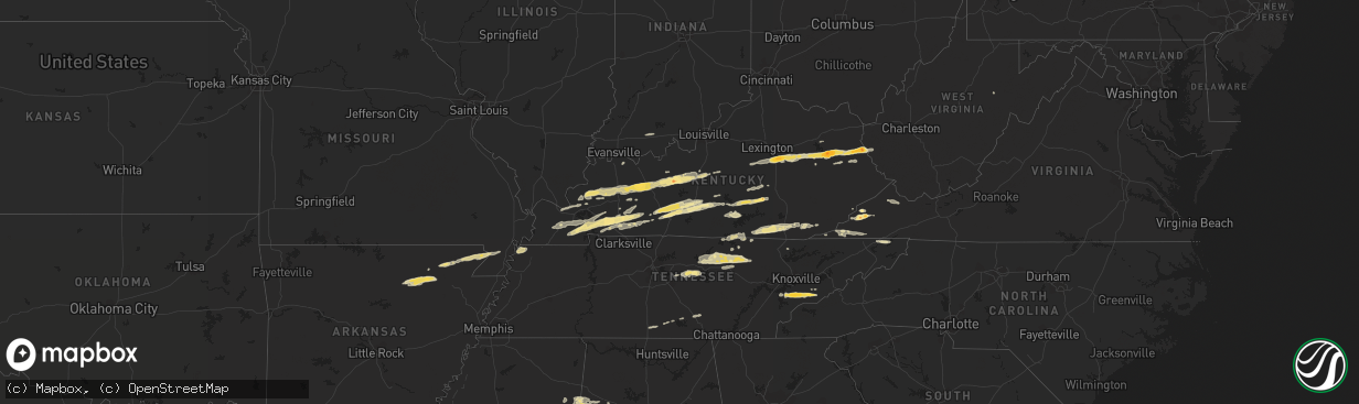
Hail Map in Virginia on February 29, 2012
The weather event in Virginia on February 29, 2012 includes Hail map. 13 states and 318 cities were impacted and suffered possible damage. The total estimated number of properties impacted is 0.
Want more than just the map?
Turn this storm into a full workflow.
- Owner + property data so you know who to knock
- OnDemand branded weather history reports to win the "did we even have hail?" argument
- RoofTrace estimate so reps stop guessing numbers at the door
Bought this map? Upgrade within 7 days and we'll credit the $230. (10-15 min setup call)
Hail
0
Estimated number of impacted properties by a 1.00" hail or larger0
Estimated number of impacted properties by a 1.75" hail or larger0
Estimated number of impacted properties by a 2.50" hail or largerStorm reports in Virginia
Virginia
| Date | Description |
|---|---|
| 02/29/20125:50 PM CST | Trees and power lines down. |
| 02/29/20125:10 PM CST | A local report indicates 1.75 inch wind near 3 SE WISE |
| 02/29/20125:10 PM CST | Several trees down. |
| 02/29/20124:30 PM CST | Trees down in douthat state park and along state route 629. |
| 02/29/20123:48 PM CST | Trees down on route 687 near the intersection of route 603 |
| 02/28/201211:35 PM CST | Several trees down. |
| 02/28/201211:05 PM CST | Possible tornado damage in gate city. A few trees and power lines down. A small storage shed was blown into the road at benton dr and starnes st. A porch collapsed that |
| 02/28/201211:05 PM CST | Possible tornado damage in gate city. A few trees and power lines down. A small storage shed was destroyed and a mobile home roof was blown off. |
| 02/28/201211:00 PM CST | Trees and power lines down. |
| 02/28/20126:30 PM CST | A local report indicates 1.00 inch wind near 1 N LEBANON |
| 02/28/20126:28 PM CST | Observed on white top road north of konnarock |
| 02/28/20126:15 PM CST | Trees and power lines down. |
All States Impacted by Hail Map on February 29, 2012
Cities Impacted by Hail Map on February 29, 2012
- Eastview, KY
- Cerulean, KY
- Crofton, KY
- Flatgap, KY
- Stambaugh, KY
- Lowmansville, KY
- Blaine, KY
- Sitka, KY
- Ulysses, KY
- Louisa, KY
- Trenton, KY
- Pocahontas, AR
- Walnut Ridge, AR
- West Liberty, KY
- Elkfork, KY
- Burghill, OH
- Greenway, AR
- Knobel, AR
- Delaplaine, AR
- Holcomb, MO
- Marmaduke, AR
- Kennett, MO
- Paragould, AR
- Lafe, AR
- Rector, AR
- Piggott, AR
- Tiptonville, TN
- Troy, TN
- Hornbeak, TN
- Union City, TN
- Tallassee, TN
- Walland, TN
- Townsend, TN
- Maryville, TN
- Park City, KY
- Horse Cave, KY
- Cave City, KY
- Smiths Grove, KY
- Center, KY
- Edmonton, KY
- Knob Lick, KY
- Glasgow, KY
- Winchester, KY
- Richmond, KY
- Franklin, PA
- Wise, VA
- Pound, VA
- Fayetteville, TN
- Monterey, TN
- Crawford, TN
- Greenwood Springs, MS
- Sulligent, AL
- Leitchfield, KY
- Rockholds, KY
- Stearns, KY
- Whitley City, KY
- Pine Knot, KY
- Williamsburg, KY
- Duffield, VA
- Blackwater, VA
- Cookeville, TN
- Salem, KY
- Marion, KY
- Sevierville, TN
- Spearsville, LA
- Greensburg, KY
- Millwood, KY
- Clarkson, KY
- Caneyville, KY
- Hardin, KY
- Almo, KY
- Dexter, KY
- Irvine, KY
- Waco, KY
- Fort Gay, WV
- Martha, KY
- Wellington, KY
- Denniston, KY
- Jeffersonville, KY
- Lexington, KY
- Stanton, KY
- Keaton, KY
- Frenchburg, KY
- Ezel, KY
- Clay City, KY
- Pall Mall, TN
- Allons, TN
- Monticello, KY
- Byrdstown, TN
- Monroe, TN
- Albany, KY
- Dawson Springs, KY
- Nebo, KY
- Providence, KY
- Madisonville, KY
- Hanson, KY
- Manitou, KY
- Princeton, KY
- Batesville, AR
- Saffell, AR
- Lynn, AR
- Sulphur Rock, AR
- Cave City, AR
- Strawberry, AR
- Alicia, AR
- Mayfield, KY
- Hamburg, AR
- Crossett, AR
- Barbourville, KY
- Elkton, KY
- Hopkinsville, KY
- Cadiz, KY
- Gracey, KY
- Murray, KY
- Benton, KY
- Frankewing, TN
- Dellrose, TN
- Pulaski, TN
- Jamestown, TN
- Eubank, KY
- Hardyville, KY
- Russellville, KY
- Brownsville, KY
- Mammoth Cave, KY
- Bowling Green, KY
- Rockfield, KY
- Rocky Hill, KY
- Oakland, KY
- Auburn, KY
- Morgantown, KY
- Cord, AR
- Crab Orchard, KY
- Huttig, AR
- Strong, AR
- Sharon Grove, KY
- Pembroke, KY
- Olmstead, KY
- Allensville, KY
- Jamestown, KY
- Russell Springs, KY
- Science Hill, KY
- Somerset, KY
- Jonesville, VA
- Pennington Gap, VA
- Gatlinburg, TN
- Greenback, TN
- Big Stone Gap, VA
- Norton, VA
- Coeburn, VA
- Fourmile, KY
- Flat Lick, KY
- Pineville, KY
- Eldridge, AL
- Greenville, KY
- Glens Fork, KY
- Columbia, KY
- Liberty, TN
- Dowelltown, TN
- Clearfield, KY
- Morehead, KY
- Mulberry, TN
- Deer Lodge, TN
- Wilder, TN
- Gainesboro, TN
- Grimsley, TN
- Rickman, TN
- Bloomington Springs, TN
- Alpine, TN
- Hilham, TN
- Clarkrange, TN
- Livingston, TN
- Centertown, KY
- Lenoir City, TN
- Liberty, KY
- Waynesburg, KY
- Kings Mountain, KY
- Stanford, KY
- Hustonville, KY
- Middleburg, KY
- Granville, TN
- Baxter, TN
- Buffalo Valley, TN
- Chestnut Mound, TN
- Allred, TN
- Guthrie, KY
- Herndon, KY
- Lewisburg, KY
- Hardinsburg, KY
- McDaniels, KY
- Falls Of Rough, KY
- Gate City, VA
- Clinton, TN
- Dunlow, WV
- Big Clifty, KY
- Cromwell, KY
- Fredonia, KY
- Beaver Dam, KY
- Cecilia, KY
- Rosine, KY
- Hudson, KY
- Island, KY
- Sacramento, KY
- McHenry, KY
- White Mills, KY
- Glendale, KY
- Horse Branch, KY
- Hartford, KY
- Olaton, KY
- Sonora, KY
- Bremen, KY
- Central City, KY
- Elmwood, TN
- Raven, VA
- Rowe, VA
- Vansant, VA
- Oakwood, VA
- Means, KY
- Wadley, AL
- Cragford, AL
- Ashland, AL
- Salyersville, KY
- Nicholasville, KY
- Appalachia, VA
- Pelham, TN
- Hillsboro, TN
- Jacksboro, TN
- Saint Paul, VA
- Andersonville, TN
- Elizabethtown, KY
- Friendsville, TN
- Windsor, KY
- Bethelridge, KY
- Dunnville, KY
- Nancy, KY
- Bristol, TN
- Coalton, WV
- Williamsfield, OH
- Artemus, KY
- Walker, KY
- Trosper, KY
- Stoney Fork, KY
- Kettle Island, KY
- Arjay, KY
- La Follette, TN
- Rocky Top, TN
- Eolia, KY
- Bryants Store, KY
- Amory, MS
- Hickory, KY
- Caryville, TN
- Maynardville, TN
- New Haven, KY
- Loretto, KY
- New Hope, KY
- Smithville, TN
- Lancaster, TN
- Auburntown, TN
- Watertown, TN
- Alexandria, TN
- Portageville, MO
- Wardell, MO
- O'Kean, AR
- Hodgenville, KY
- Detroit, AL
- Caledonia, MS
- Gattman, MS
- Moody, AL
- Odenville, AL
- Eddyville, KY
- Symsonia, KY
- Farmington, KY
- Kirksey, KY
- Tiline, KY
- Grand Rivers, KY
- Ledbetter, KY
- Brookport, IL
- Paducah, KY
- Smithland, KY
- Campton, KY
- Graham, KY
- Harrodsburg, KY
- Wilmore, KY
- Lancaster, KY
- Pigeon Forge, TN
- Eudora, AR
- Lynchburg, TN
- Blountville, TN
- Drakesboro, KY
- Lascassas, TN
- Lebanon, TN
- Parkers Lake, KY
- Corbin, KY
- Revelo, KY
- Norris, TN
- Birdseye, IN
- Ferdinand, IN
- Black Rock, AR
- Tullahoma, TN
- Estill Springs, TN
- Coldiron, KY
- Hulen, KY
- Aberdeen, MS
- Campbellsville, KY
- Rose Hill, VA
- Henderson, KY
- Cleveland, OH
- Thelma, KY
- Tutor Key, KY
- Paintsville, KY
- Boons Camp, KY
- Staffordsville, KY
- Meally, KY
- Hagerhill, KY
- Williamsport, KY
- Winfield, AL
- Guin, AL
- Beaverton, AL
- Parkdale, AR


