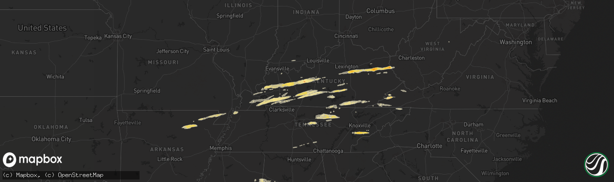
Hail Map in Tennessee on February 29, 2012
The weather event in Tennessee on February 29, 2012 includes Hail map. 13 states and 318 cities were impacted and suffered possible damage. The total estimated number of properties impacted is 0.
Want more than just the map?
Turn this storm into a full workflow.
- Owner + property data so you know who to knock
- OnDemand branded weather history reports to win the "did we even have hail?" argument
- RoofTrace estimate so reps stop guessing numbers at the door
Bought this map? Upgrade within 7 days and we'll credit the $230. (10-15 min setup call)
Hail
0
Estimated number of impacted properties by a 1.00" hail or larger0
Estimated number of impacted properties by a 1.75" hail or larger0
Estimated number of impacted properties by a 2.50" hail or largerStorm reports in Tennessee
Tennessee
| Date | Description |
|---|---|
| 02/29/20125:50 PM CST | Several trees down. |
| 02/29/20125:50 PM CST | A local report indicates 1.00 inch wind near DAYTON |
| 02/29/20124:45 PM CST | A local report indicates 1.75 inch wind near 2 NW NORRIS |
| 02/29/20124:45 PM CST | Several trees down. |
| 02/29/20124:34 PM CST | *** 2 fatal *** cumberland county ema reported two fatalities and an unknown number of injuries in the rinnie community. Possible tornado. |
| 02/29/20124:30 PM CST | Three homes destroyed...tractor trailer flipped in the rinnie community. Area currently inaccessible due to the damage. Possible tornado. |
| 02/29/20124:10 PM CST | Barn destroyed along linville rd. |
| 02/29/20124:02 PM CST | Ef0 tornado with max winds of 85 mph. 1.8 mile damage path and 50 yd max path width. Began southwest of linville rd and tracked rapidly eastward across highway 111 befo |
| 02/29/20123:54 PM CST | *** 1 fatal *** roof damage with numerous trees down along holiday haven rd. One fatality reported. Possible tornado. |
| 02/29/20123:50 PM CST | Structural damage on arrowhead drive. Trees down on dogwood circle and highland drive. Possible tornado. |
| 02/29/20123:50 PM CST | Reports of several trees down near banner springs road...a fallen tree damaged a garage in the same area. |
| 02/29/20123:49 PM CST | A local report indicates 67 MPH wind near SMITHVILLE |
| 02/29/20123:47 PM CST | *** 1 fatal *** ef1 tornado with max winds around 90 mph. 13.7 mile damage path and 200 yd max path width. Began on north side of smithville then tracked rapidly eastwa |
| 02/29/20123:46 PM CST | A local report indicates 1.50 inch wind near JAMESTOWN |
| 02/29/20123:35 PM CST | Hail reported near highway 84 and industrial drive |
| 02/29/20123:30 PM CST | Trees down. Quarter sized hail also reported. |
| 02/29/20123:30 PM CST | Quarter sized hail reported in hickman county |
| 02/29/20123:24 PM CST | Barn suffered roof damage. Also half dollar sized hail was reported. |
| 02/29/20123:19 PM CST | 60-70 mph winds reported north of cookeville along with pea-sized hail. |
| 02/29/20122:50 PM CST | Windows were reportedly blown out of buildings in downtown carthage |
| 02/29/20122:00 AM CST | Few trees down. |
| 02/29/20121:05 AM CST | Storm survey determined an ef0 touched down 3 miles s of seymour on keener rd. Path length 1.5 miles...path width of 70 yards...and 75 mph winds. |
| 02/28/20127:02 PM CST | Dispatch reported a few trees down on waldens creek road. |
| 02/28/20126:55 PM CST | A local report indicates 1.50 inch wind near WEARS VALLEY |
| 02/28/20126:50 PM CST | A local report indicates 1.00 inch wind near TOWNSEND |
| 02/28/20126:40 PM CST | A local report indicates 1.75 inch wind near 4 S MARYVILLE |
| 02/28/20126:35 PM CST | Possible tornado. Several trees down and structural damage to storage building. |
| 02/28/20126:30 PM CST | Storm survey determined an ef0 tornado touched down 3 miles ne of greenback on maple ln. Path length 3/4 of a mile...path width of 100 yards...and 85 mph winds. |
All States Impacted by Hail Map on February 29, 2012
Cities Impacted by Hail Map on February 29, 2012
- Eastview, KY
- Cerulean, KY
- Crofton, KY
- Flatgap, KY
- Stambaugh, KY
- Lowmansville, KY
- Blaine, KY
- Sitka, KY
- Ulysses, KY
- Louisa, KY
- Trenton, KY
- Pocahontas, AR
- Walnut Ridge, AR
- West Liberty, KY
- Elkfork, KY
- Burghill, OH
- Greenway, AR
- Knobel, AR
- Delaplaine, AR
- Holcomb, MO
- Marmaduke, AR
- Kennett, MO
- Paragould, AR
- Lafe, AR
- Rector, AR
- Piggott, AR
- Tiptonville, TN
- Troy, TN
- Hornbeak, TN
- Union City, TN
- Tallassee, TN
- Walland, TN
- Townsend, TN
- Maryville, TN
- Park City, KY
- Horse Cave, KY
- Cave City, KY
- Smiths Grove, KY
- Center, KY
- Edmonton, KY
- Knob Lick, KY
- Glasgow, KY
- Winchester, KY
- Richmond, KY
- Franklin, PA
- Wise, VA
- Pound, VA
- Fayetteville, TN
- Monterey, TN
- Crawford, TN
- Greenwood Springs, MS
- Sulligent, AL
- Leitchfield, KY
- Rockholds, KY
- Stearns, KY
- Whitley City, KY
- Pine Knot, KY
- Williamsburg, KY
- Duffield, VA
- Blackwater, VA
- Cookeville, TN
- Salem, KY
- Marion, KY
- Sevierville, TN
- Spearsville, LA
- Greensburg, KY
- Millwood, KY
- Clarkson, KY
- Caneyville, KY
- Hardin, KY
- Almo, KY
- Dexter, KY
- Irvine, KY
- Waco, KY
- Fort Gay, WV
- Martha, KY
- Wellington, KY
- Denniston, KY
- Jeffersonville, KY
- Lexington, KY
- Stanton, KY
- Keaton, KY
- Frenchburg, KY
- Ezel, KY
- Clay City, KY
- Pall Mall, TN
- Allons, TN
- Monticello, KY
- Byrdstown, TN
- Monroe, TN
- Albany, KY
- Dawson Springs, KY
- Nebo, KY
- Providence, KY
- Madisonville, KY
- Hanson, KY
- Manitou, KY
- Princeton, KY
- Batesville, AR
- Saffell, AR
- Lynn, AR
- Sulphur Rock, AR
- Cave City, AR
- Strawberry, AR
- Alicia, AR
- Mayfield, KY
- Hamburg, AR
- Crossett, AR
- Barbourville, KY
- Elkton, KY
- Hopkinsville, KY
- Cadiz, KY
- Gracey, KY
- Murray, KY
- Benton, KY
- Frankewing, TN
- Dellrose, TN
- Pulaski, TN
- Jamestown, TN
- Eubank, KY
- Hardyville, KY
- Russellville, KY
- Brownsville, KY
- Mammoth Cave, KY
- Bowling Green, KY
- Rockfield, KY
- Rocky Hill, KY
- Oakland, KY
- Auburn, KY
- Morgantown, KY
- Cord, AR
- Crab Orchard, KY
- Huttig, AR
- Strong, AR
- Sharon Grove, KY
- Pembroke, KY
- Olmstead, KY
- Allensville, KY
- Jamestown, KY
- Russell Springs, KY
- Science Hill, KY
- Somerset, KY
- Jonesville, VA
- Pennington Gap, VA
- Gatlinburg, TN
- Greenback, TN
- Big Stone Gap, VA
- Norton, VA
- Coeburn, VA
- Fourmile, KY
- Flat Lick, KY
- Pineville, KY
- Eldridge, AL
- Greenville, KY
- Glens Fork, KY
- Columbia, KY
- Liberty, TN
- Dowelltown, TN
- Clearfield, KY
- Morehead, KY
- Mulberry, TN
- Deer Lodge, TN
- Wilder, TN
- Gainesboro, TN
- Grimsley, TN
- Rickman, TN
- Bloomington Springs, TN
- Alpine, TN
- Hilham, TN
- Clarkrange, TN
- Livingston, TN
- Centertown, KY
- Lenoir City, TN
- Liberty, KY
- Waynesburg, KY
- Kings Mountain, KY
- Stanford, KY
- Hustonville, KY
- Middleburg, KY
- Granville, TN
- Baxter, TN
- Buffalo Valley, TN
- Chestnut Mound, TN
- Allred, TN
- Guthrie, KY
- Herndon, KY
- Lewisburg, KY
- Hardinsburg, KY
- McDaniels, KY
- Falls Of Rough, KY
- Gate City, VA
- Clinton, TN
- Dunlow, WV
- Big Clifty, KY
- Cromwell, KY
- Fredonia, KY
- Beaver Dam, KY
- Cecilia, KY
- Rosine, KY
- Hudson, KY
- Island, KY
- Sacramento, KY
- McHenry, KY
- White Mills, KY
- Glendale, KY
- Horse Branch, KY
- Hartford, KY
- Olaton, KY
- Sonora, KY
- Bremen, KY
- Central City, KY
- Elmwood, TN
- Raven, VA
- Rowe, VA
- Vansant, VA
- Oakwood, VA
- Means, KY
- Wadley, AL
- Cragford, AL
- Ashland, AL
- Salyersville, KY
- Nicholasville, KY
- Appalachia, VA
- Pelham, TN
- Hillsboro, TN
- Jacksboro, TN
- Saint Paul, VA
- Andersonville, TN
- Elizabethtown, KY
- Friendsville, TN
- Windsor, KY
- Bethelridge, KY
- Dunnville, KY
- Nancy, KY
- Bristol, TN
- Coalton, WV
- Williamsfield, OH
- Artemus, KY
- Walker, KY
- Trosper, KY
- Stoney Fork, KY
- Kettle Island, KY
- Arjay, KY
- La Follette, TN
- Rocky Top, TN
- Eolia, KY
- Bryants Store, KY
- Amory, MS
- Hickory, KY
- Caryville, TN
- Maynardville, TN
- New Haven, KY
- Loretto, KY
- New Hope, KY
- Smithville, TN
- Lancaster, TN
- Auburntown, TN
- Watertown, TN
- Alexandria, TN
- Portageville, MO
- Wardell, MO
- O'Kean, AR
- Hodgenville, KY
- Detroit, AL
- Caledonia, MS
- Gattman, MS
- Moody, AL
- Odenville, AL
- Eddyville, KY
- Symsonia, KY
- Farmington, KY
- Kirksey, KY
- Tiline, KY
- Grand Rivers, KY
- Ledbetter, KY
- Brookport, IL
- Paducah, KY
- Smithland, KY
- Campton, KY
- Graham, KY
- Harrodsburg, KY
- Wilmore, KY
- Lancaster, KY
- Pigeon Forge, TN
- Eudora, AR
- Lynchburg, TN
- Blountville, TN
- Drakesboro, KY
- Lascassas, TN
- Lebanon, TN
- Parkers Lake, KY
- Corbin, KY
- Revelo, KY
- Norris, TN
- Birdseye, IN
- Ferdinand, IN
- Black Rock, AR
- Tullahoma, TN
- Estill Springs, TN
- Coldiron, KY
- Hulen, KY
- Aberdeen, MS
- Campbellsville, KY
- Rose Hill, VA
- Henderson, KY
- Cleveland, OH
- Thelma, KY
- Tutor Key, KY
- Paintsville, KY
- Boons Camp, KY
- Staffordsville, KY
- Meally, KY
- Hagerhill, KY
- Williamsport, KY
- Winfield, AL
- Guin, AL
- Beaverton, AL
- Parkdale, AR


