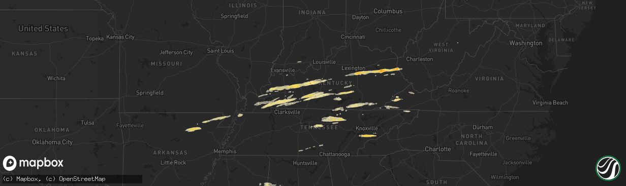
Hail Map in Kentucky on February 29, 2012
The weather event in Kentucky on February 29, 2012 includes Hail map. 13 states and 318 cities were impacted and suffered possible damage. The total estimated number of properties impacted is 0.
Want more than just the map?
Turn this storm into a full workflow.
- Owner + property data so you know who to knock
- OnDemand branded weather history reports to win the "did we even have hail?" argument
- RoofTrace estimate so reps stop guessing numbers at the door
Bought this map? Upgrade within 7 days and we'll credit the $230. (10-15 min setup call)
Hail
0
Estimated number of impacted properties by a 1.00" hail or larger0
Estimated number of impacted properties by a 1.75" hail or larger0
Estimated number of impacted properties by a 2.50" hail or largerStorm reports in Kentucky
Kentucky
| Date | Description |
|---|---|
| 02/29/20124:00 PM CST | Tree fell across road on hwy 229 approx. 1/4 to 1/2 mile north of us 25 e in knox county. Tree is partially blocking north bound lane of road. |
| 02/29/20123:52 PM CST | Trees down along u.s. Highway 119. Time estimated from radar. |
| 02/29/20123:50 PM CST | A local report indicates 1.00 inch wind near PINEVILLE |
| 02/29/20123:48 PM CST | Trees down on cow fork road. Time estimated from radar. |
| 02/29/20123:46 PM CST | Trees down on petes blossom road. Time estimated from radar. |
| 02/29/20123:44 PM CST | Trees down on dorton branch road. |
| 02/29/20123:31 PM CST | A local report indicates 1.00 inch wind near BARBOURVILLE |
| 02/29/20123:18 PM CST | Some minor damage to out buildings and trees down along hwy 26. Time estimated from radar. |
| 02/29/20123:01 PM CST | Structural damage. Occurred between 401 and 431 pm. |
| 02/29/20123:01 PM CST | Trees and large limbs down. |
| 02/29/20122:52 PM CST | Trees down on route 2059 in woodman. |
| 02/29/20122:52 PM CST | Trees down on highway 194 and highway 632. |
| 02/29/20122:42 PM CST | Trees down on highway 194. |
| 02/29/20122:40 PM CST | Trees down on highway 167 just north of mount pisgah. Time estimated from radar. |
| 02/29/20122:30 PM CST | Multiple trees down. Time estimated from radar. |
| 02/29/20122:05 PM CST | Tree down in nancy. Time estimated from radar. |
| 02/29/20122:03 PM CST | Large limbs were blown down. Time of event is estimated from radar. |
| 02/29/20122:00 PM CST | Tree blown over onto a bridge on highway 1502 just south of waldo. Some damage occurred to bridge. Time based on radar. |
| 02/29/20121:56 PM CST | Tree down on morning branch road. Time estimated from radar. |
| 02/29/20121:55 PM CST | Trees down and some structure damage at the intersection of hwy 39 and hwy 635. Time estimated by radar. |
| 02/29/20121:53 PM CST | An ef-1 tornado touched down at 253 pm est about 3 miles east-northeast of science hill. The tornado continued to the east-northeast approximately 1.5 miles before diss |
| 02/29/20121:50 PM CST | Several structures damaged behind valley view super market. Time estimated by radar. |
| 02/29/20121:50 PM CST | Trees down and large tree branches down. Wind estimated at 60 mph. Possible funnel cloud spotted. |
| 02/29/20121:48 PM CST | Large limbs were blown down. Time of event is estimated from radar. |
| 02/29/20121:42 PM CST | Tree down on udel branch road. Time estimated from radar. |
| 02/29/20121:42 PM CST | Powerlines also down near faubush |
| 02/29/20121:42 PM CST | Roof partially blown off home. Porch damaged. Occurred on robinson branch road. |
| 02/29/20121:41 PM CST | South fork ridge road 910 near ky 127 |
| 02/29/20121:41 PM CST | South fork ridge road 910 near ky 127 |
| 02/29/20121:41 PM CST | Trees...power lines down near webbs crossroad near ky 127 |
| 02/29/20121:40 PM CST | Saw wall cloud...estimated 65 mph winds |
| 02/29/20121:35 PM CST | A local report indicates 1.75 inch wind near 2 ESE GALLUP |
| 02/29/20121:27 PM CST | The tornado from russell county continued into southern casey county. It weakened to ef-1 strength in casey county damaging trees...barns...and outbuildings before it l |
| 02/29/20121:27 PM CST | A local report indicates 1.50 inch wind near CHARLEY |
| 02/29/20121:25 PM CST | Ef-2 touched down near highway 127 and mount union road. Tracked northeast into southern casey county and lifted near the town of windsor. Outbuildings along with barns |
| 02/29/20121:23 PM CST | Mobile homes destroyed along with some barns and homes on patty ridge road. |
| 02/29/20121:23 PM CST | Trees and power lines down and debris in roads just north of sycamore flat. |
| 02/29/20121:22 PM CST | Ef-2 touched down west of highway 127 in northern russell county. Tracked northeast into southern casey county and lifted west of the town of windsor. The worst damaged |
| 02/29/20121:22 PM CST | One inch hail reported along state highway 127 5 miles northwest of russell springs. Also...debris was reported. Radar indicated a very strong circulation. |
| 02/29/20121:19 PM CST | Tree down across hwy 1010. Employee estimated diameter between 1.5 and 2 feet. Time estimated from radar. |
| 02/29/20121:18 PM CST | A local report indicates 1.00 inch wind near RELIEF |
| 02/29/20121:15 PM CST | A local report indicates 1.00 inch wind near 6 NW PAINTSVILLE |
| 02/29/201212:57 PM CST | Trees down and structures damaged on 191 and 460 west just outside of west liberty. |
| 02/29/201212:47 PM CST | An ef-1 tornado touched down se of center near herbert hodges road. It damaged 3 or 4 barns and snapped numerous trees along its 1.1 mile path. The tornado lifted 1.5 m |
| 02/29/201212:47 PM CST | A local report indicates 2.00 inch wind near WEST LIBERTY |
| 02/29/201212:45 PM CST | Occurred on tabernacle road. Large limbs down. Limbs damaged guttering on home. |
| 02/29/201212:45 PM CST | A local report indicates 1.00 inch wind near 4 SW CENTER |
| 02/29/201212:45 PM CST | A local report indicates 1.50 inch wind near 3 WNW WEST LIBERTY |
| 02/29/201212:42 PM CST | An ef2 tornado touched down at 142 pm est 1 mile north of grassy creek and moved east southeast lifting off near the community of malone at 150 pm est. The path length |
| 02/29/201212:35 PM CST | Trees down onto hwy 1693. Time estimated from radar. |
| 02/29/201212:15 PM CST | At wku campus |
| 02/29/201212:15 PM CST | Large tree limbs down on mill knob. Time estimated from radar. |
| 02/29/201212:15 PM CST | Time estimated from radar. |
| 02/29/201212:11 PM CST | A local report indicates 1.00 inch wind near MONROE |
| 02/29/201212:05 PM CST | Time estimated from radar. |
| 02/29/201212:05 PM CST | Large limbs down on snow creek. Time estimated from radar. |
| 02/29/201211:44 AM CST | A local report indicates 1.75 inch wind near REDHOUSE |
| 02/29/201210:40 AM CST | A local report indicates 1.50 inch wind near 6 NE HOPKINSVILLE |
| 02/29/201210:30 AM CST | Large barn on the ground with tin rolled up on adjacent roof. Appears to be straight line winds. |
| 02/29/201210:28 AM CST | A local report indicates 1.00 inch wind near HOPKINSVILLE |
| 02/29/201210:18 AM CST | House destroyed on stiles ford road and ky 210 |
| 02/29/201210:18 AM CST | Debris and funnel seen near fairgrounds |
| 02/29/201210:18 AM CST | Several homes destroyed near us highway 31e |
| 02/29/201210:14 AM CST | A local report indicates 1.00 inch wind near CADIZ |
| 02/29/201210:13 AM CST | Nws storm survey team determined an ef-2 tornado touched down near downtown hodgenville at citizens union bank and a nearby neighborhood where several sturdy houses wer |
| 02/29/201210:12 AM CST | Nws storm survey team determined an ef-2 tornado touched down near downtown hodgenville at citizens union bank and a nearby neighborhood where several sturdy houses wer |
| 02/29/201210:10 AM CST | *** 1 inj *** nws storm survey team determined an ef-2 tornado touched down a couple miles west of hodgenville where roof and tree damage were found. |
| 02/29/201210:05 AM CST | Also...dime size hail reported |
| 02/29/20129:58 AM CST | Unconfirmed report of a tornado on the ground in a field by north sinking fork road. |
| 02/29/20129:58 AM CST | 3 or 4 houses and barns heavily damaged along ky 224 |
| 02/29/20129:58 AM CST | Woman trapped in damaged home |
| 02/29/20129:55 AM CST | A local report indicates 71 MPH wind near CADIZ |
| 02/29/20129:53 AM CST | A local report indicates 1.00 inch wind near BIG CLIFTY |
| 02/29/20129:52 AM CST | House damaged |
| 02/29/20129:51 AM CST | A local report indicates 70 MPH wind near GRACEY |
| 02/29/20129:48 AM CST | A local report indicates 1.50 inch wind near GRACEY |
| 02/29/20129:42 AM CST | *** 1 inj *** nws storm survey team determined an ef-2 tornado in the town of horntown in eastern grayson county. Three mobile homes were destroyed and one was blown 40 |
| 02/29/20129:42 AM CST | *** 1 inj *** nws storm survey team determined an ef-2 tornado in the town of horntown in eastern grayson county. Three mobile homes were destroyed and one was blown 40 |
| 02/29/20129:40 AM CST | Quarter size hail in cadiz. |
| 02/29/20129:36 AM CST | Quarter size hail at the airport. |
| 02/29/20129:36 AM CST | Quarter size hail in the lbl area. |
| 02/29/20129:24 AM CST | A local report indicates 1.00 inch wind near AURORA |
| 02/29/20129:10 AM CST | A local report indicates 1.00 inch wind near DEXTER |
| 02/29/20129:08 AM CST | Factory damage near intersection of ky 210 and us 31w. |
| 02/29/20129:08 AM CST | Significant damage to homes and businesses. Survey team at site. |
| 02/29/20129:08 AM CST | Harry owen trucking heavily damaged near ky 210. |
| 02/29/20128:56 AM CST | Significant damage to homes and businesses. Ef-2 damage has been confirmed by a survey team. |
| 02/29/20128:50 AM CST | A local report indicates 1.00 inch wind near BIG CLIFTY |
| 02/29/20128:49 AM CST | Reports of roofs blown off homes and 1 school. |
| 02/29/20128:45 AM CST | A very brief tornado touched down in southwestern greenville. Path length 700 feet. Average path width 100 feet. Peak winds 95 mph...rated at ef1. Damage highlights...a |
| 02/29/20128:26 AM CST | A local report indicates 1.75 inch wind near LEITCHFIELD |
| 02/29/20128:15 AM CST | Tree down on antioch rd |
| 02/29/20127:45 AM CST | Limbs down across ky 339 |
| 02/29/20127:35 AM CST | A local report indicates 60 MPH wind near GOSHEN |
| 02/29/20127:28 AM CST | A local report indicates 1.00 inch wind near BENTON |
| 02/29/20127:20 AM CST | Metal shed destroyed. |
| 02/29/20127:08 AM CST | A local report indicates 1.75 inch wind near CENTERTOWN |
| 02/29/20127:08 AM CST | A spotter estimated 60 mph winds. Several large branches were downed. |
| 02/29/20126:57 AM CST | Quarter size hail reported in the community. |
| 02/29/20126:45 AM CST | Quarter size hail reported. |
| 02/29/20126:40 AM CST | Tornado on the ground reported at exit 44 along the pennyrile parkway. |
| 02/29/20126:40 AM CST | Severly damaged home blocking roadway. |
| 02/29/20126:14 AM CST | A local report indicates 60 MPH wind near HEBBARDSVILLE |
| 02/29/20126:03 AM CST | Dime size hail reported with the storm. |
| 02/29/20126:00 AM CST | *** 2 inj *** possible tornado...near ellis park 3 to 4 river homes destroyed with 2 injures reported. Late report. |
All States Impacted by Hail Map on February 29, 2012
Cities Impacted by Hail Map on February 29, 2012
- Eastview, KY
- Cerulean, KY
- Crofton, KY
- Flatgap, KY
- Stambaugh, KY
- Lowmansville, KY
- Blaine, KY
- Sitka, KY
- Ulysses, KY
- Louisa, KY
- Trenton, KY
- Pocahontas, AR
- Walnut Ridge, AR
- West Liberty, KY
- Elkfork, KY
- Burghill, OH
- Greenway, AR
- Knobel, AR
- Delaplaine, AR
- Holcomb, MO
- Marmaduke, AR
- Kennett, MO
- Paragould, AR
- Lafe, AR
- Rector, AR
- Piggott, AR
- Tiptonville, TN
- Troy, TN
- Hornbeak, TN
- Union City, TN
- Tallassee, TN
- Walland, TN
- Townsend, TN
- Maryville, TN
- Park City, KY
- Horse Cave, KY
- Cave City, KY
- Smiths Grove, KY
- Center, KY
- Edmonton, KY
- Knob Lick, KY
- Glasgow, KY
- Winchester, KY
- Richmond, KY
- Franklin, PA
- Wise, VA
- Pound, VA
- Fayetteville, TN
- Monterey, TN
- Crawford, TN
- Greenwood Springs, MS
- Sulligent, AL
- Leitchfield, KY
- Rockholds, KY
- Stearns, KY
- Whitley City, KY
- Pine Knot, KY
- Williamsburg, KY
- Duffield, VA
- Blackwater, VA
- Cookeville, TN
- Salem, KY
- Marion, KY
- Sevierville, TN
- Spearsville, LA
- Greensburg, KY
- Millwood, KY
- Clarkson, KY
- Caneyville, KY
- Hardin, KY
- Almo, KY
- Dexter, KY
- Irvine, KY
- Waco, KY
- Fort Gay, WV
- Martha, KY
- Wellington, KY
- Denniston, KY
- Jeffersonville, KY
- Lexington, KY
- Stanton, KY
- Keaton, KY
- Frenchburg, KY
- Ezel, KY
- Clay City, KY
- Pall Mall, TN
- Allons, TN
- Monticello, KY
- Byrdstown, TN
- Monroe, TN
- Albany, KY
- Dawson Springs, KY
- Nebo, KY
- Providence, KY
- Madisonville, KY
- Hanson, KY
- Manitou, KY
- Princeton, KY
- Batesville, AR
- Saffell, AR
- Lynn, AR
- Sulphur Rock, AR
- Cave City, AR
- Strawberry, AR
- Alicia, AR
- Mayfield, KY
- Hamburg, AR
- Crossett, AR
- Barbourville, KY
- Elkton, KY
- Hopkinsville, KY
- Cadiz, KY
- Gracey, KY
- Murray, KY
- Benton, KY
- Frankewing, TN
- Dellrose, TN
- Pulaski, TN
- Jamestown, TN
- Eubank, KY
- Hardyville, KY
- Russellville, KY
- Brownsville, KY
- Mammoth Cave, KY
- Bowling Green, KY
- Rockfield, KY
- Rocky Hill, KY
- Oakland, KY
- Auburn, KY
- Morgantown, KY
- Cord, AR
- Crab Orchard, KY
- Huttig, AR
- Strong, AR
- Sharon Grove, KY
- Pembroke, KY
- Olmstead, KY
- Allensville, KY
- Jamestown, KY
- Russell Springs, KY
- Science Hill, KY
- Somerset, KY
- Jonesville, VA
- Pennington Gap, VA
- Gatlinburg, TN
- Greenback, TN
- Big Stone Gap, VA
- Norton, VA
- Coeburn, VA
- Fourmile, KY
- Flat Lick, KY
- Pineville, KY
- Eldridge, AL
- Greenville, KY
- Glens Fork, KY
- Columbia, KY
- Liberty, TN
- Dowelltown, TN
- Clearfield, KY
- Morehead, KY
- Mulberry, TN
- Deer Lodge, TN
- Wilder, TN
- Gainesboro, TN
- Grimsley, TN
- Rickman, TN
- Bloomington Springs, TN
- Alpine, TN
- Hilham, TN
- Clarkrange, TN
- Livingston, TN
- Centertown, KY
- Lenoir City, TN
- Liberty, KY
- Waynesburg, KY
- Kings Mountain, KY
- Stanford, KY
- Hustonville, KY
- Middleburg, KY
- Granville, TN
- Baxter, TN
- Buffalo Valley, TN
- Chestnut Mound, TN
- Allred, TN
- Guthrie, KY
- Herndon, KY
- Lewisburg, KY
- Hardinsburg, KY
- McDaniels, KY
- Falls Of Rough, KY
- Gate City, VA
- Clinton, TN
- Dunlow, WV
- Big Clifty, KY
- Cromwell, KY
- Fredonia, KY
- Beaver Dam, KY
- Cecilia, KY
- Rosine, KY
- Hudson, KY
- Island, KY
- Sacramento, KY
- McHenry, KY
- White Mills, KY
- Glendale, KY
- Horse Branch, KY
- Hartford, KY
- Olaton, KY
- Sonora, KY
- Bremen, KY
- Central City, KY
- Elmwood, TN
- Raven, VA
- Rowe, VA
- Vansant, VA
- Oakwood, VA
- Means, KY
- Wadley, AL
- Cragford, AL
- Ashland, AL
- Salyersville, KY
- Nicholasville, KY
- Appalachia, VA
- Pelham, TN
- Hillsboro, TN
- Jacksboro, TN
- Saint Paul, VA
- Andersonville, TN
- Elizabethtown, KY
- Friendsville, TN
- Windsor, KY
- Bethelridge, KY
- Dunnville, KY
- Nancy, KY
- Bristol, TN
- Coalton, WV
- Williamsfield, OH
- Artemus, KY
- Walker, KY
- Trosper, KY
- Stoney Fork, KY
- Kettle Island, KY
- Arjay, KY
- La Follette, TN
- Rocky Top, TN
- Eolia, KY
- Bryants Store, KY
- Amory, MS
- Hickory, KY
- Caryville, TN
- Maynardville, TN
- New Haven, KY
- Loretto, KY
- New Hope, KY
- Smithville, TN
- Lancaster, TN
- Auburntown, TN
- Watertown, TN
- Alexandria, TN
- Portageville, MO
- Wardell, MO
- O'Kean, AR
- Hodgenville, KY
- Detroit, AL
- Caledonia, MS
- Gattman, MS
- Moody, AL
- Odenville, AL
- Eddyville, KY
- Symsonia, KY
- Farmington, KY
- Kirksey, KY
- Tiline, KY
- Grand Rivers, KY
- Ledbetter, KY
- Brookport, IL
- Paducah, KY
- Smithland, KY
- Campton, KY
- Graham, KY
- Harrodsburg, KY
- Wilmore, KY
- Lancaster, KY
- Pigeon Forge, TN
- Eudora, AR
- Lynchburg, TN
- Blountville, TN
- Drakesboro, KY
- Lascassas, TN
- Lebanon, TN
- Parkers Lake, KY
- Corbin, KY
- Revelo, KY
- Norris, TN
- Birdseye, IN
- Ferdinand, IN
- Black Rock, AR
- Tullahoma, TN
- Estill Springs, TN
- Coldiron, KY
- Hulen, KY
- Aberdeen, MS
- Campbellsville, KY
- Rose Hill, VA
- Henderson, KY
- Cleveland, OH
- Thelma, KY
- Tutor Key, KY
- Paintsville, KY
- Boons Camp, KY
- Staffordsville, KY
- Meally, KY
- Hagerhill, KY
- Williamsport, KY
- Winfield, AL
- Guin, AL
- Beaverton, AL
- Parkdale, AR


