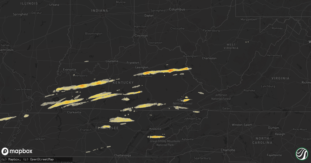
Hail Map on February 29, 2012
Get this storm
February 29 map
$229
one time, instant access
Download today. No call, no setup
Keep the $229
Bought the map and want the full workflow? Apply the entire $229 to a subscription within 7 days. None of it is wasted.
Every map, not just this one
This buys you this map. Subscription and you get every map we run, in the markets you choose from a few cities to whole states to nationwide. Plus real-time alerts the moment a storm fires.
Contact data
Name, contact info, occupancy, even credit band for addresses in the footprint. You go from where it hit to who to call.
Become the source they trust
Unlimited branding weather history reports on demand. You already have the documented answer ready for the property owner, and you are the one who showed up with it.
Property data and RoofTrace estimates
Pull up any address you have got, its value and the exact code rules for that jurisdiction, straight from One Click Code. Then RoofTrace estimates the squares, pitch, and roof value, priced the way you price.
States Impacted by Hail Map on February 29, 2012
Storm reports
Tennessee
| Date | Description |
|---|---|
| 02/29/20125:50 PM CST | Several trees down. |
| 02/29/20125:50 PM CST | A local report indicates 1.00 inch wind near DAYTON |
| 02/29/20124:45 PM CST | Several trees down. |
| 02/29/20124:45 PM CST | A local report indicates 1.75 inch wind near 2 NW NORRIS |
| 02/29/20124:34 PM CST | *** 2 fatal *** cumberland county ema reported two fatalities and an unknown number of injuries in the rinnie community. Possible tornado. |
| 02/29/20124:30 PM CST | Three homes destroyed...tractor trailer flipped in the rinnie community. Area currently inaccessible due to the damage. Possible tornado. |
| 02/29/20124:10 PM CST | Barn destroyed along linville rd. |
| 02/29/20124:02 PM CST | Ef0 tornado with max winds of 85 mph. 1.8 mile damage path and 50 yd max path width. Began southwest of linville rd and tracked rapidly eastward across highway 111 befo |
| 02/29/20123:54 PM CST | *** 1 fatal *** roof damage with numerous trees down along holiday haven rd. One fatality reported. Possible tornado. |
| 02/29/20123:50 PM CST | Reports of several trees down near banner springs road...a fallen tree damaged a garage in the same area. |
| 02/29/20123:50 PM CST | Structural damage on arrowhead drive. Trees down on dogwood circle and highland drive. Possible tornado. |
| 02/29/20123:49 PM CST | A local report indicates 67 MPH wind near SMITHVILLE |
| 02/29/20123:47 PM CST | *** 1 fatal *** ef1 tornado with max winds around 90 mph. 13.7 mile damage path and 200 yd max path width. Began on north side of smithville then tracked rapidly eastwa |
| 02/29/20123:46 PM CST | A local report indicates 1.50 inch wind near JAMESTOWN |
| 02/29/20123:35 PM CST | Hail reported near highway 84 and industrial drive |
| 02/29/20123:30 PM CST | Trees down. Quarter sized hail also reported. |
| 02/29/20123:30 PM CST | Quarter sized hail reported in hickman county |
| 02/29/20123:24 PM CST | Barn suffered roof damage. Also half dollar sized hail was reported. |
| 02/29/20123:19 PM CST | 60-70 mph winds reported north of cookeville along with pea-sized hail. |
| 02/29/20122:50 PM CST | Windows were reportedly blown out of buildings in downtown carthage |
| 02/29/20122:00 AM CST | Few trees down. |
| 02/29/20121:05 AM CST | Storm survey determined an ef0 touched down 3 miles s of seymour on keener rd. Path length 1.5 miles...path width of 70 yards...and 75 mph winds. |
| 02/28/20127:02 PM CST | Dispatch reported a few trees down on waldens creek road. |
| 02/28/20126:55 PM CST | A local report indicates 1.50 inch wind near WEARS VALLEY |
| 02/28/20126:50 PM CST | A local report indicates 1.00 inch wind near TOWNSEND |
| 02/28/20126:40 PM CST | A local report indicates 1.75 inch wind near 4 S MARYVILLE |
| 02/28/20126:35 PM CST | Possible tornado. Several trees down and structural damage to storage building. |
| 02/28/20126:30 PM CST | Storm survey determined an ef0 tornado touched down 3 miles ne of greenback on maple ln. Path length 3/4 of a mile...path width of 100 yards...and 85 mph winds. |
Mississippi
| Date | Description |
|---|---|
| 02/29/20124:45 PM CST | Numerous large limbs were down. |
| 02/29/20124:30 PM CST | Multiple trees down across the town |
| 02/29/20124:29 PM CST | 60 mph gusts estimated by trained spotter/ham radio operator |
| 02/29/20124:21 PM CST | Multiple trees down in smithville |
| 02/29/20124:21 PM CST | 60 mph gusts estimated by trained spotter/ham radio operator |
| 02/29/20123:50 PM CST | Roof off of a house on old highway 49. Powerlines down at town water pumping station. |
Alabama
| Date | Description |
|---|---|
| 02/29/20124:38 PM CST | Five out of the eight light poles at the sulligent high school baseball field were either collapsed or bent in half. One home near the school received significant damag |
Indiana
| Date | Description |
|---|---|
| 02/29/20128:38 AM CST | Tree fell over us 421 blocking highway |
| 02/29/20127:35 AM CST | Tree down on phone lines on antioch rd. Corrected earlier lsr. |
| 02/29/20127:22 AM CST | Minor roof damge at charlestown middle school |
| 02/29/20126:52 AM CST | A local report indicates 60 MPH wind near PILOT KNOB |
| 02/29/20126:05 AM CST | Tornado reported by state trooper near the community of newburgh. Widespread damage throughout the city proper. Rescue teams are responding. |
| 02/29/20126:00 AM CST | Numerous trees down along highway 66. |
Ohio
| Date | Description |
|---|---|
| 02/28/20126:26 PM CST | A local report indicates 1.00 inch wind near RAVENNA |
West Virginia
| Date | Description |
|---|---|
| 02/29/20125:30 PM CST | One tree down on unity road near athens |
| 02/29/20125:25 PM CST | Two trees knocked down power lines on pine grove road |
| 02/29/20125:20 PM CST | One tree down on gardner road near spanishburg |
| 02/29/20124:34 PM CST | Several trees down in union and the surrounding area. |
| 02/29/20124:25 PM CST | Several trees down in the big draft area. |
| 02/29/20124:16 PM CST | One tree down over a power line on leonard-cordova road |
| 02/29/20123:53 PM CST | One tree down on brush road |
| 02/29/20123:30 PM CST | Several outbuildings damaged... One barn with half the roof blown off. Numerous trees uprooted or damaged. |
| 02/29/20123:30 PM CST | 10 inch diameter pine treetop snapped off |
| 02/29/20123:16 PM CST | One tree down over a power line on leonard-cordova road |
| 02/29/20123:12 PM CST | Tree down in mount nebo |
| 02/29/20123:10 PM CST | Tree down in craigsville |
| 02/29/20123:10 PM CST | Tree and powerlines down along possum creek road about 7 miles east of ansted around the hico area |
| 02/29/20123:00 PM CST | Trees and powerlines down along saturday road just east of ansted |
| 02/29/20123:00 PM CST | Trees down at several locations along route 49 in mingo county |
| 02/29/20122:53 PM CST | Tree down in hookersville |
| 02/29/20122:20 PM CST | Tree down across route 3 just north of the town of seth |
| 02/29/20122:20 PM CST | Trees down along route 17 in the powell creek area |
| 02/28/201210:15 PM CST | A local report indicates 1.00 inch wind near COALTON |
North Carolina
| Date | Description |
|---|---|
| 02/28/20127:25 PM CST | Trees down to the west of interstate 40 blocking the road and one large tree down across one lane of east bound interstate 40. |
| 02/28/20127:25 PM CST | A tree on a house on pigeon street and powerlines down across much of haywood county. |
| 02/28/20127:15 PM CST | Numerous trees down in burnsville and parts of the town without power. First report from spotter then confirmed with county. |
Virginia
| Date | Description |
|---|---|
| 02/29/20125:50 PM CST | Trees and power lines down. |
| 02/29/20125:10 PM CST | Several trees down. |
| 02/29/20125:10 PM CST | A local report indicates 1.75 inch wind near 3 SE WISE |
| 02/29/20124:30 PM CST | Trees down in douthat state park and along state route 629. |
| 02/29/20123:48 PM CST | Trees down on route 687 near the intersection of route 603 |
| 02/28/201211:35 PM CST | Several trees down. |
| 02/28/201211:05 PM CST | Possible tornado damage in gate city. A few trees and power lines down. A small storage shed was blown into the road at benton dr and starnes st. A porch collapsed that |
| 02/28/201211:05 PM CST | Possible tornado damage in gate city. A few trees and power lines down. A small storage shed was destroyed and a mobile home roof was blown off. |
| 02/28/201211:00 PM CST | Trees and power lines down. |
| 02/28/20126:30 PM CST | A local report indicates 1.00 inch wind near 1 N LEBANON |
| 02/28/20126:28 PM CST | Observed on white top road north of konnarock |
| 02/28/20126:15 PM CST | Trees and power lines down. |
Kentucky
| Date | Description |
|---|---|
| 02/29/20124:00 PM CST | Tree fell across road on hwy 229 approx. 1/4 to 1/2 mile north of us 25 e in knox county. Tree is partially blocking north bound lane of road. |
| 02/29/20123:52 PM CST | Trees down along u.s. Highway 119. Time estimated from radar. |
| 02/29/20123:50 PM CST | A local report indicates 1.00 inch wind near PINEVILLE |
| 02/29/20123:48 PM CST | Trees down on cow fork road. Time estimated from radar. |
| 02/29/20123:46 PM CST | Trees down on petes blossom road. Time estimated from radar. |
| 02/29/20123:44 PM CST | Trees down on dorton branch road. |
| 02/29/20123:31 PM CST | A local report indicates 1.00 inch wind near BARBOURVILLE |
| 02/29/20123:18 PM CST | Some minor damage to out buildings and trees down along hwy 26. Time estimated from radar. |
| 02/29/20123:01 PM CST | Structural damage. Occurred between 401 and 431 pm. |
| 02/29/20123:01 PM CST | Trees and large limbs down. |
| 02/29/20122:52 PM CST | Trees down on highway 194 and highway 632. |
| 02/29/20122:52 PM CST | Trees down on route 2059 in woodman. |
| 02/29/20122:42 PM CST | Trees down on highway 194. |
| 02/29/20122:40 PM CST | Trees down on highway 167 just north of mount pisgah. Time estimated from radar. |
| 02/29/20122:30 PM CST | Multiple trees down. Time estimated from radar. |
| 02/29/20122:05 PM CST | Tree down in nancy. Time estimated from radar. |
| 02/29/20122:03 PM CST | Large limbs were blown down. Time of event is estimated from radar. |
| 02/29/20122:00 PM CST | Tree blown over onto a bridge on highway 1502 just south of waldo. Some damage occurred to bridge. Time based on radar. |
| 02/29/20121:56 PM CST | Tree down on morning branch road. Time estimated from radar. |
| 02/29/20121:55 PM CST | Trees down and some structure damage at the intersection of hwy 39 and hwy 635. Time estimated by radar. |
| 02/29/20121:53 PM CST | An ef-1 tornado touched down at 253 pm est about 3 miles east-northeast of science hill. The tornado continued to the east-northeast approximately 1.5 miles before diss |
| 02/29/20121:50 PM CST | Trees down and large tree branches down. Wind estimated at 60 mph. Possible funnel cloud spotted. |
| 02/29/20121:50 PM CST | Several structures damaged behind valley view super market. Time estimated by radar. |
| 02/29/20121:48 PM CST | Large limbs were blown down. Time of event is estimated from radar. |
| 02/29/20121:42 PM CST | Powerlines also down near faubush |
| 02/29/20121:42 PM CST | Roof partially blown off home. Porch damaged. Occurred on robinson branch road. |
| 02/29/20121:42 PM CST | Tree down on udel branch road. Time estimated from radar. |
| 02/29/20121:41 PM CST | South fork ridge road 910 near ky 127 |
| 02/29/20121:41 PM CST | Trees...power lines down near webbs crossroad near ky 127 |
| 02/29/20121:41 PM CST | South fork ridge road 910 near ky 127 |
| 02/29/20121:40 PM CST | Saw wall cloud...estimated 65 mph winds |
| 02/29/20121:35 PM CST | A local report indicates 1.75 inch wind near 2 ESE GALLUP |
| 02/29/20121:27 PM CST | The tornado from russell county continued into southern casey county. It weakened to ef-1 strength in casey county damaging trees...barns...and outbuildings before it l |
| 02/29/20121:27 PM CST | A local report indicates 1.50 inch wind near CHARLEY |
| 02/29/20121:25 PM CST | Ef-2 touched down near highway 127 and mount union road. Tracked northeast into southern casey county and lifted near the town of windsor. Outbuildings along with barns |
| 02/29/20121:23 PM CST | Trees and power lines down and debris in roads just north of sycamore flat. |
| 02/29/20121:23 PM CST | Mobile homes destroyed along with some barns and homes on patty ridge road. |
| 02/29/20121:22 PM CST | Ef-2 touched down west of highway 127 in northern russell county. Tracked northeast into southern casey county and lifted west of the town of windsor. The worst damaged |
| 02/29/20121:22 PM CST | One inch hail reported along state highway 127 5 miles northwest of russell springs. Also...debris was reported. Radar indicated a very strong circulation. |
| 02/29/20121:19 PM CST | Tree down across hwy 1010. Employee estimated diameter between 1.5 and 2 feet. Time estimated from radar. |
| 02/29/20121:18 PM CST | A local report indicates 1.00 inch wind near RELIEF |
| 02/29/20121:15 PM CST | A local report indicates 1.00 inch wind near 6 NW PAINTSVILLE |
| 02/29/201212:57 PM CST | Trees down and structures damaged on 191 and 460 west just outside of west liberty. |
| 02/29/201212:47 PM CST | An ef-1 tornado touched down se of center near herbert hodges road. It damaged 3 or 4 barns and snapped numerous trees along its 1.1 mile path. The tornado lifted 1.5 m |
| 02/29/201212:47 PM CST | A local report indicates 2.00 inch wind near WEST LIBERTY |
| 02/29/201212:45 PM CST | A local report indicates 1.00 inch wind near 4 SW CENTER |
| 02/29/201212:45 PM CST | A local report indicates 1.50 inch wind near 3 WNW WEST LIBERTY |
| 02/29/201212:45 PM CST | Occurred on tabernacle road. Large limbs down. Limbs damaged guttering on home. |
| 02/29/201212:42 PM CST | An ef2 tornado touched down at 142 pm est 1 mile north of grassy creek and moved east southeast lifting off near the community of malone at 150 pm est. The path length |
| 02/29/201212:35 PM CST | Trees down onto hwy 1693. Time estimated from radar. |
| 02/29/201212:15 PM CST | At wku campus |
| 02/29/201212:15 PM CST | Large tree limbs down on mill knob. Time estimated from radar. |
| 02/29/201212:15 PM CST | Time estimated from radar. |
| 02/29/201212:11 PM CST | A local report indicates 1.00 inch wind near MONROE |
| 02/29/201212:05 PM CST | Time estimated from radar. |
| 02/29/201212:05 PM CST | Large limbs down on snow creek. Time estimated from radar. |
| 02/29/201211:44 AM CST | A local report indicates 1.75 inch wind near REDHOUSE |
| 02/29/201210:40 AM CST | A local report indicates 1.50 inch wind near 6 NE HOPKINSVILLE |
| 02/29/201210:30 AM CST | Large barn on the ground with tin rolled up on adjacent roof. Appears to be straight line winds. |
| 02/29/201210:28 AM CST | A local report indicates 1.00 inch wind near HOPKINSVILLE |
| 02/29/201210:18 AM CST | Debris and funnel seen near fairgrounds |
| 02/29/201210:18 AM CST | Several homes destroyed near us highway 31e |
| 02/29/201210:18 AM CST | House destroyed on stiles ford road and ky 210 |
| 02/29/201210:14 AM CST | A local report indicates 1.00 inch wind near CADIZ |
| 02/29/201210:13 AM CST | Nws storm survey team determined an ef-2 tornado touched down near downtown hodgenville at citizens union bank and a nearby neighborhood where several sturdy houses wer |
| 02/29/201210:12 AM CST | Nws storm survey team determined an ef-2 tornado touched down near downtown hodgenville at citizens union bank and a nearby neighborhood where several sturdy houses wer |
| 02/29/201210:10 AM CST | *** 1 inj *** nws storm survey team determined an ef-2 tornado touched down a couple miles west of hodgenville where roof and tree damage were found. |
| 02/29/201210:05 AM CST | Also...dime size hail reported |
| 02/29/20129:58 AM CST | Unconfirmed report of a tornado on the ground in a field by north sinking fork road. |
| 02/29/20129:58 AM CST | 3 or 4 houses and barns heavily damaged along ky 224 |
| 02/29/20129:58 AM CST | Woman trapped in damaged home |
| 02/29/20129:55 AM CST | A local report indicates 71 MPH wind near CADIZ |
| 02/29/20129:53 AM CST | A local report indicates 1.00 inch wind near BIG CLIFTY |
| 02/29/20129:52 AM CST | House damaged |
| 02/29/20129:51 AM CST | A local report indicates 70 MPH wind near GRACEY |
| 02/29/20129:48 AM CST | A local report indicates 1.50 inch wind near GRACEY |
| 02/29/20129:42 AM CST | *** 1 inj *** nws storm survey team determined an ef-2 tornado in the town of horntown in eastern grayson county. Three mobile homes were destroyed and one was blown 40 |
| 02/29/20129:42 AM CST | *** 1 inj *** nws storm survey team determined an ef-2 tornado in the town of horntown in eastern grayson county. Three mobile homes were destroyed and one was blown 40 |
| 02/29/20129:40 AM CST | Quarter size hail in cadiz. |
| 02/29/20129:36 AM CST | Quarter size hail in the lbl area. |
| 02/29/20129:36 AM CST | Quarter size hail at the airport. |
| 02/29/20129:24 AM CST | A local report indicates 1.00 inch wind near AURORA |
| 02/29/20129:10 AM CST | A local report indicates 1.00 inch wind near DEXTER |
| 02/29/20129:08 AM CST | Harry owen trucking heavily damaged near ky 210. |
| 02/29/20129:08 AM CST | Factory damage near intersection of ky 210 and us 31w. |
| 02/29/20129:08 AM CST | Significant damage to homes and businesses. Survey team at site. |
| 02/29/20128:56 AM CST | Significant damage to homes and businesses. Ef-2 damage has been confirmed by a survey team. |
| 02/29/20128:50 AM CST | A local report indicates 1.00 inch wind near BIG CLIFTY |
| 02/29/20128:49 AM CST | Reports of roofs blown off homes and 1 school. |
| 02/29/20128:45 AM CST | A very brief tornado touched down in southwestern greenville. Path length 700 feet. Average path width 100 feet. Peak winds 95 mph...rated at ef1. Damage highlights...a |
| 02/29/20128:26 AM CST | A local report indicates 1.75 inch wind near LEITCHFIELD |
| 02/29/20128:15 AM CST | Tree down on antioch rd |
| 02/29/20127:45 AM CST | Limbs down across ky 339 |
| 02/29/20127:35 AM CST | A local report indicates 60 MPH wind near GOSHEN |
| 02/29/20127:28 AM CST | A local report indicates 1.00 inch wind near BENTON |
| 02/29/20127:20 AM CST | Metal shed destroyed. |
| 02/29/20127:08 AM CST | A local report indicates 1.75 inch wind near CENTERTOWN |
| 02/29/20127:08 AM CST | A spotter estimated 60 mph winds. Several large branches were downed. |
| 02/29/20126:57 AM CST | Quarter size hail reported in the community. |
| 02/29/20126:45 AM CST | Quarter size hail reported. |
| 02/29/20126:40 AM CST | Severly damaged home blocking roadway. |
| 02/29/20126:40 AM CST | Tornado on the ground reported at exit 44 along the pennyrile parkway. |
| 02/29/20126:14 AM CST | A local report indicates 60 MPH wind near HEBBARDSVILLE |
| 02/29/20126:03 AM CST | Dime size hail reported with the storm. |
| 02/29/20126:00 AM CST | *** 2 inj *** possible tornado...near ellis park 3 to 4 river homes destroyed with 2 injures reported. Late report. |
Arkansas
| Date | Description |
|---|---|
| 02/29/20122:40 PM CST | A local report indicates 1.00 inch wind near WILMOT |
| 02/29/20127:01 AM CST | A local report indicates 1.00 inch wind near GREENWAY |
| 02/29/20126:50 AM CST | A local report indicates 1.50 inch wind near 1 NNW STRAWBERRY |
| 02/29/20126:20 AM CST | A local report indicates 1.25 inch wind near SHANNON |
Cities Impacted by Hail Map on February 29, 2012
- Eastview, KY
- Cerulean, KY
- Crofton, KY
- Flatgap, KY
- Stambaugh, KY
- Lowmansville, KY
- Blaine, KY
- Sitka, KY
- Ulysses, KY
- Louisa, KY
- Trenton, KY
- Pocahontas, AR
- Walnut Ridge, AR
- West Liberty, KY
- Elkfork, KY
- Burghill, OH
- Greenway, AR
- Knobel, AR
- Delaplaine, AR
- Holcomb, MO
- Marmaduke, AR
- Kennett, MO
- Paragould, AR
- Lafe, AR
- Rector, AR
- Piggott, AR
- Tiptonville, TN
- Troy, TN
- Hornbeak, TN
- Union City, TN
- Tallassee, TN
- Walland, TN
- Townsend, TN
- Maryville, TN
- Park City, KY
- Horse Cave, KY
- Cave City, KY
- Smiths Grove, KY
- Center, KY
- Edmonton, KY
- Knob Lick, KY
- Glasgow, KY
- Winchester, KY
- Richmond, KY
- Franklin, PA
- Wise, VA
- Pound, VA
- Fayetteville, TN
- Monterey, TN
- Crawford, TN
- Greenwood Springs, MS
- Sulligent, AL
- Leitchfield, KY
- Rockholds, KY
- Stearns, KY
- Whitley City, KY
- Pine Knot, KY
- Williamsburg, KY
- Duffield, VA
- Blackwater, VA
- Cookeville, TN
- Salem, KY
- Marion, KY
- Sevierville, TN
- Spearsville, LA
- Greensburg, KY
- Millwood, KY
- Clarkson, KY
- Caneyville, KY
- Hardin, KY
- Almo, KY
- Dexter, KY
- Irvine, KY
- Waco, KY
- Fort Gay, WV
- Martha, KY
- Wellington, KY
- Denniston, KY
- Jeffersonville, KY
- Lexington, KY
- Stanton, KY
- Keaton, KY
- Frenchburg, KY
- Ezel, KY
- Clay City, KY
- Pall Mall, TN
- Allons, TN
- Monticello, KY
- Byrdstown, TN
- Monroe, TN
- Albany, KY
- Dawson Springs, KY
- Nebo, KY
- Providence, KY
- Madisonville, KY
- Hanson, KY
- Manitou, KY
- Princeton, KY
- Batesville, AR
- Saffell, AR
- Lynn, AR
- Sulphur Rock, AR
- Cave City, AR
- Strawberry, AR
- Alicia, AR
- Mayfield, KY
- Hamburg, AR
- Crossett, AR
- Barbourville, KY
- Elkton, KY
- Hopkinsville, KY
- Cadiz, KY
- Gracey, KY
- Murray, KY
- Benton, KY
- Frankewing, TN
- Dellrose, TN
- Pulaski, TN
- Jamestown, TN
- Eubank, KY
- Hardyville, KY
- Russellville, KY
- Brownsville, KY
- Mammoth Cave, KY
- Bowling Green, KY
- Rockfield, KY
- Rocky Hill, KY
- Oakland, KY
- Auburn, KY
- Morgantown, KY
- Cord, AR
- Crab Orchard, KY
- Huttig, AR
- Strong, AR
- Sharon Grove, KY
- Pembroke, KY
- Olmstead, KY
- Allensville, KY
- Jamestown, KY
- Russell Springs, KY
- Science Hill, KY
- Somerset, KY
- Jonesville, VA
- Pennington Gap, VA
- Gatlinburg, TN
- Greenback, TN
- Big Stone Gap, VA
- Norton, VA
- Coeburn, VA
- Fourmile, KY
- Flat Lick, KY
- Pineville, KY
- Eldridge, AL
- Greenville, KY
- Glens Fork, KY
- Columbia, KY
- Liberty, TN
- Dowelltown, TN
- Clearfield, KY
- Morehead, KY
- Mulberry, TN
- Deer Lodge, TN
- Wilder, TN
- Gainesboro, TN
- Grimsley, TN
- Rickman, TN
- Bloomington Springs, TN
- Alpine, TN
- Hilham, TN
- Clarkrange, TN
- Livingston, TN
- Centertown, KY
- Lenoir City, TN
- Liberty, KY
- Waynesburg, KY
- Kings Mountain, KY
- Stanford, KY
- Hustonville, KY
- Middleburg, KY
- Granville, TN
- Baxter, TN
- Buffalo Valley, TN
- Chestnut Mound, TN
- Allred, TN
- Guthrie, KY
- Herndon, KY
- Lewisburg, KY
- Hardinsburg, KY
- McDaniels, KY
- Falls Of Rough, KY
- Gate City, VA
- Clinton, TN
- Dunlow, WV
- Big Clifty, KY
- Cromwell, KY
- Fredonia, KY
- Beaver Dam, KY
- Cecilia, KY
- Rosine, KY
- Hudson, KY
- Island, KY
- Sacramento, KY
- McHenry, KY
- White Mills, KY
- Glendale, KY
- Horse Branch, KY
- Hartford, KY
- Olaton, KY
- Sonora, KY
- Bremen, KY
- Central City, KY
- Elmwood, TN
- Raven, VA
- Rowe, VA
- Vansant, VA
- Oakwood, VA
- Means, KY
- Wadley, AL
- Cragford, AL
- Ashland, AL
- Salyersville, KY
- Nicholasville, KY
- Appalachia, VA
- Pelham, TN
- Hillsboro, TN
- Jacksboro, TN
- Saint Paul, VA
- Andersonville, TN
- Elizabethtown, KY
- Friendsville, TN
- Windsor, KY
- Bethelridge, KY
- Dunnville, KY
- Nancy, KY
- Bristol, TN
- Coalton, WV
- Williamsfield, OH
- Artemus, KY
- Walker, KY
- Trosper, KY
- Stoney Fork, KY
- Kettle Island, KY
- Arjay, KY
- La Follette, TN
- Rocky Top, TN
- Eolia, KY
- Bryants Store, KY
- Amory, MS
- Hickory, KY
- Caryville, TN
- Maynardville, TN
- New Haven, KY
- Loretto, KY
- New Hope, KY
- Smithville, TN
- Lancaster, TN
- Auburntown, TN
- Watertown, TN
- Alexandria, TN
- Portageville, MO
- Wardell, MO
- O'Kean, AR
- Hodgenville, KY
- Detroit, AL
- Caledonia, MS
- Gattman, MS
- Moody, AL
- Odenville, AL
- Eddyville, KY
- Symsonia, KY
- Farmington, KY
- Kirksey, KY
- Tiline, KY
- Grand Rivers, KY
- Ledbetter, KY
- Brookport, IL
- Paducah, KY
- Smithland, KY
- Campton, KY
- Graham, KY
- Harrodsburg, KY
- Wilmore, KY
- Lancaster, KY
- Pigeon Forge, TN
- Eudora, AR
- Lynchburg, TN
- Blountville, TN
- Drakesboro, KY
- Lascassas, TN
- Lebanon, TN
- Parkers Lake, KY
- Corbin, KY
- Revelo, KY
- Norris, TN
- Birdseye, IN
- Ferdinand, IN
- Black Rock, AR
- Tullahoma, TN
- Estill Springs, TN
- Coldiron, KY
- Hulen, KY
- Aberdeen, MS
- Campbellsville, KY
- Rose Hill, VA
- Henderson, KY
- Cleveland, OH
- Thelma, KY
- Tutor Key, KY
- Paintsville, KY
- Boons Camp, KY
- Staffordsville, KY
- Meally, KY
- Hagerhill, KY
- Williamsport, KY
- Winfield, AL
- Guin, AL
- Beaverton, AL
- Parkdale, AR