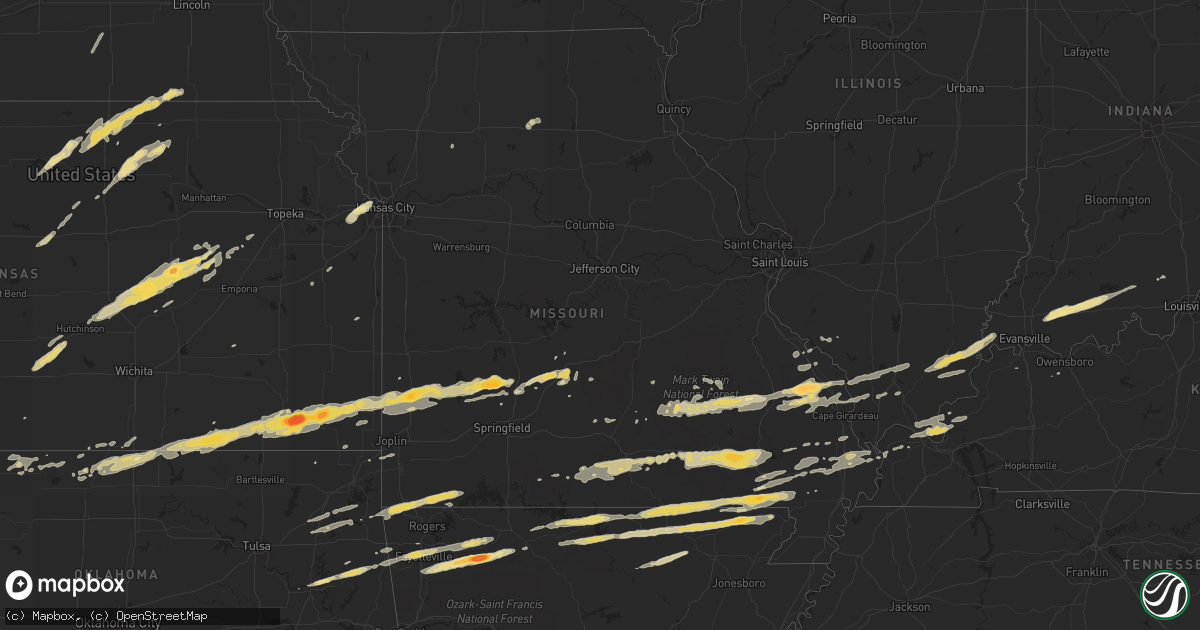
Hail Map in Missouri on February 28, 2012
Get this storm
February 28 map
$229
one time, instant access
Download today. No call, no setup
Keep the $229
Bought the map and want the full workflow? Apply the entire $229 to a subscription within 7 days. None of it is wasted.
Every map, not just this one
This buys you this map. Subscription and you get every map we run, in the markets you choose from a few cities to whole states to nationwide. Plus real-time alerts the moment a storm fires.
Contact data
Name, contact info, occupancy, even credit band for addresses in the footprint. You go from where it hit to who to call.
Become the source they trust
Unlimited branding weather history reports on demand. You already have the documented answer ready for the property owner, and you are the one who showed up with it.
Property data and RoofTrace estimates
Pull up any address you have got, its value and the exact code rules for that jurisdiction, straight from One Click Code. Then RoofTrace estimates the squares, pitch, and roof value, priced the way you price.
Storm reports in Missouri
Missouri
| Date | Description |
|---|---|
| 02/28/201211:48 AM CST | Golfball sized hail reported at fairgrounds. |
| 02/28/20125:20 AM CST | *** 1 inj *** emergency manager reporting widespread damage across the northern third of cape giradeau county. Manager is asking for no one to enter the area to allow e |
| 02/28/20124:50 AM CST | Possible tornado. Barn and chicken farm destroyed. House damaged. Widespread tree and power line damage along highway 408 near the intersection of hwy 403. Late report. |
| 02/28/20124:41 AM CST | Golf ball size hail reported near the community of neelyville. |
| 02/28/20124:30 AM CST | Numerous power outages with large amount of tree debris. Winds estimated 55 mph. |
| 02/28/20124:24 AM CST | Nws storm survey reveals an ef1 tornado which started just east of bell city in stoddard county to 3 miles southeast of benton in scott county. Details can be found in |
| 02/28/20124:18 AM CST | Line of damage from oak ridge to pocahantas missouri. Numerous structural and tree damage. Power outages. No injures reported at this time. Possible tornado. |
| 02/28/20124:15 AM CST | Em reports path of damage between ottawild and brownwood.late report. |
| 02/28/20124:00 AM CST | *** 1 inj *** emergency manager reporting widespread damage across the northern third of cape giradeau county. Manager is asking for no one to enter the area to allow e |
| 02/28/20124:00 AM CST | Nws storm damage survey reveals an ef3 tornado that started .5 miles west of asherville to 2 miles west of bell city. See pnspah for details. |
| 02/28/20123:59 AM CST | Numerous home stucture damage. Widespread trees and powerlines down. Damage observed by fire rescue teams and relayed to e0c. Possible tornado. No injuries reported at |
| 02/28/20123:49 AM CST | Barn blown away along highway 72 near the bollinger and cape girardeau county line. |
| 02/28/20123:41 AM CST | Power outages reported as well |
| 02/28/20123:33 AM CST | Ping pong size hail along highway v in town. Wind gust 30 to 40 mph associated with the storm. |
| 02/28/20123:30 AM CST | Antenna ripped off of home. Late report. |
| 02/28/20123:29 AM CST | Large tree uprooted..concrete wall blown over minor building damage |
| 02/28/20123:25 AM CST | 6-8 homes have roof damage along highway 72. 10 larger barns destroyed over a 5 mile area. Tree damage is widespread. Numerous power poles down. |
| 02/28/20123:11 AM CST | *** 1 inj *** 3 homes damaged... At least one with a roof missing and the others with siding removed. Another roof removed from barn. Several trees downed with diameter |
| 02/28/20123:11 AM CST | *** 1 inj *** 3 homes damaged... At least one with a roof missing and the others with siding removed. Another roof removed from barn. Several trees downed with diameter |
| 02/28/20122:49 AM CST | A local report indicates 60 MPH wind near WEST PLAINS |
| 02/28/20122:45 AM CST | Tree blown down...unknown size...blocking state hwy c east of annapolis |
| 02/28/20122:40 AM CST | Picture of hail relayed by broadcast media |
| 02/28/20122:39 AM CST | A local report indicates 1.00 inch wind near LESTERVILLE |
| 02/28/20122:39 AM CST | Power pole down |
| 02/28/20122:38 AM CST | A local report indicates 60 MPH wind near WHITE CHURCH |
| 02/28/20122:30 AM CST | A local report indicates 1.00 inch wind near POMONA |
| 02/28/20121:50 AM CST | Large oak tree down blocking hwy 49...one car ran into ditch...no injuries. Time estimated from radar. |
| 02/28/20121:45 AM CST | Ham radio esimated 60 to 70 mph wind gusts and nickel size hail. |
| 02/28/20121:45 AM CST | Ham radio reported estimated 60 mph wind gusts. |
| 02/28/20121:41 AM CST | Power lines down in cuba...also tree limbs down over us route 19. |
| 02/28/20121:35 AM CST | Large tree uprooted and several large sheds blown over on highland drive just north of cuba. |
| 02/28/20121:35 AM CST | Mountain grove police department reported power lines down. |
| 02/28/20121:35 AM CST | Large billboard blown over onto highway zz just southwest of town...still blocking road. |
| 02/28/20121:30 AM CST | Roof blown off gas station downtown branson possible tornado damage |
| 02/28/20121:29 AM CST | 20 homes destroyed. 20 damaged. |
| 02/28/20121:24 AM CST | Capri motor inn damaged. Wall of restaurant down. Sign down. Highwway patrol reports powerlines down across highway. |
| 02/28/20121:23 AM CST | Multiple trees reported down. Gas station reported damaged. Multiple service poles reported down. |
| 02/28/20121:23 AM CST | Roof blown off house and large trees down...possible tornado...near hwy 68 and hwy yy |
| 02/28/20121:20 AM CST | Multiple limbs of 4 to 5 inches down. |
| 02/28/20121:13 AM CST | *** 35 inj *** an ef-2 tornado tracked from from near kimberling city near joe bald road to 2 miles ese of kissee mills in taney county. Estimated max wind speeds of 12 |
| 02/28/20121:10 AM CST | Ham radio operator reported 60 mph wind gust |
| 02/28/20121:06 AM CST | An ef-1 rated tornado with a maximum wind speed of 90 to 95 mph tracked 19 miles from just northwest of edgar springs to the northeast to highway 68 just north of highw |
| 02/28/201212:59 AM CST | A local report indicates 75 MPH wind near 4 N FORDLAND |
| 02/28/201212:55 AM CST | Ham radio operator reported 60 mph wind gust. |
| 02/28/201212:52 AM CST | A local report indicates 60 MPH wind near NIXA |
| 02/28/201212:52 AM CST | A local report indicates 65 MPH wind near ROGERSVILLE |
| 02/28/201212:52 AM CST | Large tree uprooted..concrete wall blown over minor building damage |
| 02/28/201212:50 AM CST | Large tree blown down at the intersection of nicholas and mckenzie way |
| 02/28/201212:48 AM CST | A local report indicates 61 MPH wind near NIXA |
| 02/28/201212:40 AM CST | Nws employee reports a business sign blown down |
| 02/28/201212:33 AM CST | Reported by off duty nws meteorologist |
| 02/28/201212:30 AM CST | A local report indicates 1.75 inch wind near LEBANON |
| 02/28/201212:30 AM CST | Machine shed blown over...tree limbs blown down...and fence blown down |
| 02/28/201212:28 AM CST | Tornado on the ground just sw of lebanon |
| 02/28/201212:28 AM CST | Picture of hail relayed by broadcast media |
| 02/28/201212:25 AM CST | A local report indicates a tornado near 2 SW LEBANON |
| 02/28/201212:25 AM CST | A local report indicates 65 MPH wind near 1 E REPUBLIC |
| 02/28/201212:24 AM CST | A local report indicates 60 MPH wind near AURORA |
| 02/28/201212:22 AM CST | A brief tornado touchdown damaged around 20 recreational vehicles and an antique shop. |
| 02/28/201212:20 AM CST | Debris structure damage trees down power lines down near hwy 32 and hwy a sw of lebanon...also tracker trailers blown off i-44 from possible tornado |
| 02/28/201212:20 AM CST | Debris structure damage trees down power lines down near hwy 32 and hwy a sw of lebanon...also tracker trailers blown off i-44 from possible tornado |
| 02/28/201212:19 AM CST | Structural damage to 15 trailers rolled |
| 02/28/201212:18 AM CST | *** 1 inj *** an ef-1 magnitude tornado tracked from 2 miles northwest of phillipsburg to 1 mile southeast of lebanon several homes were damaged and trees uprooted. One |
| 02/28/201212:15 AM CST | Mcdonald county newspaper reported large limbs fell down on power lines which brought down power lines across the county causing power outages. |
| 02/28/201212:12 AM CST | Several trees blown over along state hwy e...damage to cars and home. Powerlines down over hwy 63 north of la plata |
| 02/28/201212:05 AM CST | Houses destroyed and major damage just sw of buffalo. Likely a tornado |
| 02/27/201211:58 PM CST | A nws survey indicated that an ef-1 tornado touched down near the polk and dallas county line. Another lsr will have more details on this track into dallas county. |
| 02/27/201211:56 PM CST | 1 house destroyed along with 3 turkey barns. Damage along wildlife rd. |
| 02/27/201211:50 PM CST | Barn destroyed along hwy 215 on the east side of morrisville. Partial roof damage to a house. Debris in trees. |
| 02/27/201211:50 PM CST | A local report indicates 1.75 inch wind near BOLIVAR |
| 02/27/201211:48 PM CST | Emergency management reports roof damage to a trailer and significant damage to a shed. |
| 02/27/201211:36 PM CST | A local report indicates 58 MPH wind near 2 SE LINNEUS |
| 02/27/201211:28 PM CST | Jasper county emergency management reports roof damage to a trailer. |
| 02/27/201211:26 PM CST | An ef-1 rated tornado with a maximum wind speed of 90 to 100 mph tracked 18.6 miles from 3 miles north northwest of greenfield to 2 miles east southeast of aldrich. The |
| 02/27/201211:26 PM CST | Windows blown out and barn destroyed |
| 02/27/201211:15 PM CST | Trees down. |
| 02/27/201211:15 PM CST | Possible debris path with structure damage to homes near hwy 71 just north of lamar |
| 02/27/201211:14 PM CST | Numerous trees and power lines down in lamar...possible damage with possible tornado |
| 02/27/201211:13 PM CST | Small hail |
| 02/27/201211:09 PM CST | A local report indicates 1.75 inch wind near 3 SW LAMAR |
| 02/27/201210:52 PM CST | An ef-1 rated tornado with maximum wind speed of 85 to 80 mph tracked 16 miles from 5 miles south southeast of mindenmines to 1 mile northwest of lamar crossing hwy 71. |
| 02/27/201210:46 PM CST | A local report indicates 70 MPH wind near 2 SE GLADSTONE |
| 02/27/201210:43 PM CST | Estimated near river market |
| 02/27/201210:43 PM CST | Two mobile homes blown over along with power lines down. 2 people trapped. |
| 02/27/201210:40 PM CST | 30 x 50 pole barn blown over. Nickel size hail. |
| 02/27/201210:25 PM CST | Roof blown off and wall pushed in on building under construction. |
| 02/27/201210:25 PM CST | A local report indicates 60 MPH wind near 4 N GLADSTONE |
| 02/27/201210:15 PM CST | A local report indicates 65 MPH wind near 5 E SMITHVILLE |
All States Impacted by Hail Map on February 28, 2012
Cities Impacted by Hail Map on February 28, 2012
- Seligman, MO
- Salina, OK
- Eucha, OK
- Spavinaw, OK
- Pryor, OK
- Barnard, KS
- Minneapolis, KS
- Lincoln, KS
- Augusta, KY
- Germantown, KY
- Brooksville, KY
- Alva, OK
- Lincoln, AR
- Fayetteville, AR
- Farmington, AR
- Prairie Grove, AR
- Springdale, AR
- Nash, OK
- Medford, OK
- Wakita, OK
- Walnut Grove, MO
- Morrisville, MO
- Bolivar, MO
- Huntsville, AR
- Kingston, AR
- Harrison, AR
- Qulin, MO
- Lakeview, AR
- Gamaliel, AR
- Mammoth Spring, AR
- Cotter, AR
- Corning, AR
- Myrtle, MO
- Couch, MO
- Sturkie, AR
- Oxly, MO
- Campbell, MO
- Gassville, AR
- Yellville, AR
- Neelyville, MO
- Gatewood, MO
- Maynard, AR
- Thayer, MO
- Naylor, MO
- Henderson, AR
- Ravenden, AR
- Midway, AR
- Gepp, AR
- Broseley, MO
- Elizabeth, AR
- Pocahontas, AR
- Doniphan, MO
- Bull Shoals, AR
- Warm Springs, AR
- Viola, AR
- Success, AR
- Flippin, AR
- Mountain Home, AR
- Salem, AR
- Harviell, MO
- Bernie, MO
- Poplar Bluff, MO
- Camp, AR
- Dudley, MO
- Fisk, MO
- Turon, KS
- Canton, KS
- Moundridge, KS
- Galva, KS
- Hillsboro, KS
- Jamestown, KS
- Concordia, KS
- Norway, KS
- Belleville, KS
- Haddam, KS
- Morrowville, KS
- Mahaska, KS
- Scandia, KS
- Cuba, KS
- Narka, KS
- Old Appleton, MO
- Oak Ridge, MO
- Kevil, KY
- West Paducah, KY
- Annapolis, MO
- Fredericktown, MO
- Arcadia, MO
- Willow Springs, MO
- Pomona, MO
- Dora, MO
- West Plains, MO
- Wasola, MO
- Mountain View, MO
- Vanzant, MO
- Pottersville, MO
- Brixey, MO
- Gainesville, MO
- Winona, MO
- Ava, MO
- Zanoni, MO
- Drury, MO
- Birch Tree, MO
- Liberal, MO
- Stilwell, OK
- Welling, OK
- Proctor, OK
- Tahlequah, OK
- Ellsinore, MO
- Grandin, MO
- Van Buren, MO
- Williamsville, MO
- Fremont, MO
- Cherryvale, KS
- Golconda, IL
- Brookport, IL
- Marble Hill, MO
- Palmer, KS
- Greenleaf, KS
- Clifton, KS
- Linn, KS
- Lamar, MO
- Maple City, KS
- Dexter, KS
- Elk City, KS
- Dennis, KS
- Mound Valley, KS
- McCune, KS
- Liberty, KS
- Parsons, KS
- Independence, KS
- Arkansas City, KS
- Oswego, KS
- Sedan, KS
- Cedar Vale, KS
- Havana, KS
- Green Forest, AR
- Compton, AR
- Witter, AR
- Wesley, AR
- West Fork, AR
- Elkins, AR
- Marble Falls, AR
- Horseshoe Bend, AR
- Cherokee Village, AR
- Oxford, AR
- Hardy, AR
- Ash Flat, AR
- Shidler, OK
- Frontenac, KS
- Mindenmines, MO
- Lockwood, MO
- Saint Paul, KS
- Newkirk, OK
- Weir, KS
- Girard, KS
- Oronogo, MO
- Fair Play, MO
- Buffalo, MO
- Dadeville, MO
- Arcola, MO
- Brighton, MO
- Golden City, MO
- Coffeyville, KS
- Jasper, MO
- Half Way, MO
- Greenfield, MO
- Aldrich, MO
- Asbury, MO
- Pittsburg, KS
- Jerico Springs, MO
- Altamont, KS
- Cherokee, KS
- Herington, KS
- Burdick, KS
- Lost Springs, KS
- Lincolnville, KS
- Steele City, NE
- Odell, NE
- Diller, NE
- Jewell, KS
- Randall, KS
- Glen Elder, KS
- Beloit, KS
- Redford, MO
- Ellington, MO
- Lesterville, MO
- Centerville, MO
- Salem, MO
- Burna, KY
- Marion, KY
- Salem, KY
- Welch, OK
- Raymondville, MO
- Lebanon, MO
- Miami, OK
- Mill Spring, MO
- Alton, MO
- Jonesboro, IL
- Wolf Lake, IL
- Bunker, MO
- Cobden, IL
- Daisy, MO
- Des Arc, MO
- Cape Girardeau, MO
- Millersville, MO
- Altenburg, MO
- Burfordville, MO
- Sedgewickville, MO
- Jackson, MO
- Patton, MO
- Anna, IL
- Uniontown, MO
- Marquand, MO
- Perryville, MO
- Frohna, MO
- Friedheim, MO
- Cunningham, KS
- Arlington, KS
- Partridge, KS
- Peace Valley, MO
- Washburn, MO
- Bella Vista, AR
- Pineville, MO
- Gravette, AR
- Eagle Rock, MO
- Sulphur Springs, AR
- Cassville, MO
- Noel, MO
- Bluff City, KS
- Council Grove, KS
- Fairbury, NE
- Endicott, NE
- Hollenberg, KS
- Agenda, KS
- Munden, KS
- Courtland, KS
- Pollard, AR
- Piggott, AR
- Ghent, KY
- Vevay, IN
- Strong City, KS
- Charleston, MO
- Sikeston, MO
- Bertrand, MO
- Matthews, MO
- Essex, MO
- Dexter, MO
- Bell City, MO
- Milton, KY
- Madison, IN
- Bedford, KY
- Carrollton, KY
- Owenton, KY
- Hardinsburg, IN
- Marengo, IN
- Chester, IL
- Steeleville, IL
- Abbyville, KS
- Morganville, KS
- Miltonvale, KS
- Clyde, KS
- Harrisburg, IL
- Eldorado, IL
- Equality, IL
- Ridgway, IL
- Elkland, MO
- Long Lane, MO
- Phillipsburg, MO
- Wilsey, KS
- Florence, KS
- Marion, KS
- Mount Vernon, IN
- Lehigh, KS
- Tampa, KS
- Alto Pass, IL
- Carbondale, IL
- Makanda, IL
- Pomona, IL
- Grand Tower, IL
- Marion, IL
- Metropolis, IL
- Smithland, KY
- Peabody, KS
- Biggers, AR
- Conway, MO
- Alma, KS
- Allen, KS
- Ravenden Springs, AR
- Ferdinand, IN
- Dale, IN
- Saint Anthony, IN
- Boonville, IN
- Birdseye, IN
- Lynnville, IN
- Huntingburg, IN
- Stendal, IN
- Holland, IN
- Tennyson, IN
- Eckerty, IN
- Byars, OK
- Jay, OK
- Bucklin, MO
- Cherokee, OK
- Black Rock, AR
- Poughkeepsie, AR
- Evening Shade, AR
- Cave City, AR
- Sidney, AR
- Smithville, AR
- Braman, OK
- Ellsworth, KS
- Wilson, KS
- Stoutland, MO
- Eskridge, KS
- Datto, AR
- Brookfield, MO
- Chetopa, KS
- Kansas City, KS
- Shawnee, KS
- De Soto, KS
- Linwood, KS
- Lenexa, KS
- Bonner Springs, KS
- Parma, MO
- Amorita, OK
- Knobel, AR
- Imboden, AR
- Wiseman, AR
- Wideman, AR
- Williford, AR
- Glencoe, AR
- Berryville, AR
- Ponca, AR
- Inman, KS
- Durham, KS
- Buhler, KS
- Mcpherson, KS
- Perryville, AR
- Fair Grove, MO
- Norfork, AR
- Dolph, AR
- Calico Rock, AR
- Advance, MO
- Benton, MO
- Oran, MO
- Omaha, IL
- Junction, IL
- New Haven, IL
- Grovespring, MO
- Scammon, KS
- Columbus, KS
- Westville, OK
- Summers, AR
- Carmi, IL
- Carrier Mills, IL
- Henderson, KY
- Corydon, KY
- Pekin, IN
- Big Cabin, OK
- Adair, OK
- Taswell, IN
- Gentryville, IN
- Williamsburg, KS
- Williamstown, KY
- Falmouth, KY
- Blackwell, OK
- Nardin, OK
- South Haven, KS
- Hulbert, OK
- Muskogee, OK
- Fort Gibson, OK
- Saint Mary, MO
- Siloam Springs, AR
- Watts, OK
- Neodesha, KS
- Laquey, MO
- Falcon, MO
- Mound City, KS
- Ramona, KS
- Deer Creek, OK
- Peru, KS
- Thayer, KS
- Galesburg, KS
- Shickley, NE
- Geneva, NE
- Dover, KY
- Maysville, KY
- Puxico, MO
- Hutchinson, KS
- Alta Vista, KS
- Dwight, KS
- Lecompton, KS
- Burlington, OK
- Bradleyville, MO
- Afton, OK
- Vinita, OK
- Strang, OK
- Owensboro, KY
- Alpena, AR
- Hindsville, AR
- Rector, AR
- Broken Bow, NE
- Callaway, NE
- Hampton, KY
- Yukon, MO
- Seneca, MO
- Joplin, MO
- Neosho, MO
- Quapaw, OK
- Mountain Grove, MO
- Cabool, MO
- Houston, MO
- Paducah, KY
- Tiline, KY
- Rantoul, KS
- Ottawa, KS
- Squires, MO
- Plainview, AR
- Braymer, MO
- Medicine Lodge, KS
- Stapleton, NE
- Caldwell, KS
- La Center, KY
- Wickliffe, KY
- Graff, MO
- Black, MO
- Buncombe, IL
- Paoli, IN
- English, IN
- Mount Pleasant, AR
- Lawrence, KS
- White City, KS
- Belleview, MO
- Herod, IL
- Shawneetown, IL
- Sainte Genevieve, MO
- Eureka, KS
- Percy, IL
- Bixby, MO
- Manchester, OK
- Washington, KS
- Pleasant Hope, MO
- Noble, MO
- Everton, AR
- Everton, MO
- Ozark, IL
- Goreville, IL
- Bloomfield, MO
- Sanders, KY
- Warsaw, KY
- Delphos, KS
- Aurora, KS
- Clay Center, KS
- Eldridge, MO
- Hartshorn, MO


