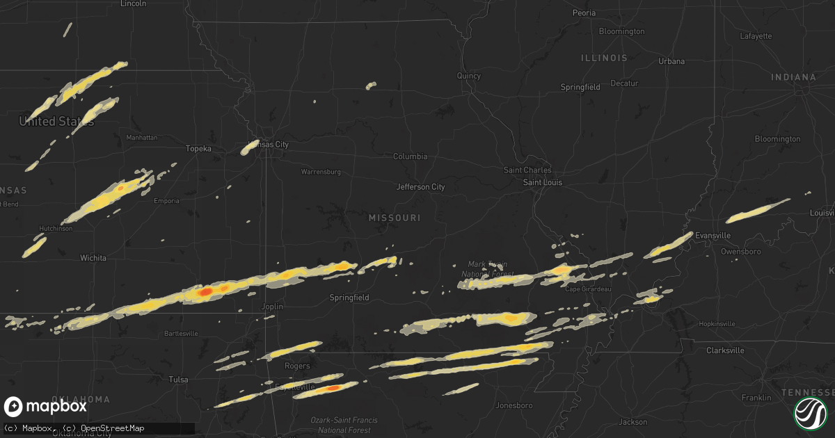
Hail Map in Kansas on February 28, 2012
Get this storm
February 28 map
$229
one time, instant access
Download today. No call, no setup
Keep the $229
Bought the map and want the full workflow? Apply the entire $229 to a subscription within 7 days. None of it is wasted.
Every map, not just this one
This buys you this map. Subscription and you get every map we run, in the markets you choose from a few cities to whole states to nationwide. Plus real-time alerts the moment a storm fires.
Contact data
Name, contact info, occupancy, even credit band for addresses in the footprint. You go from where it hit to who to call.
Become the source they trust
Unlimited branding weather history reports on demand. You already have the documented answer ready for the property owner, and you are the one who showed up with it.
Property data and RoofTrace estimates
Pull up any address you have got, its value and the exact code rules for that jurisdiction, straight from One Click Code. Then RoofTrace estimates the squares, pitch, and roof value, priced the way you price.
Storm reports in Kansas
Kansas
| Date | Description |
|---|---|
| 02/28/20125:38 PM CST | Ef0 tornado confirmed in far northwest cloud county via damage reports from survey team and multiple public reports. Tornado likely entered from the jewell-cloud county |
| 02/28/20125:38 PM CST | Possible tornado...six trees tops sheared off...uprooted tree...limbs across the road |
| 02/28/20125:38 PM CST | Possible tornado...2 large trees uprooted...tin wrapped around trees...10x40 metal building destroyed...cars damaged by flying debris...partial barn roof damaged...dela |
| 02/28/20125:30 PM CST | Damage to out buildings and house. Power polls broken and fell on c road between roads 290 and 300. Half inch hail was also reported. |
| 02/28/20125:28 PM CST | Ef0 tornado tracked for two miles from 5 miles southeast of randall to 6 miles east-southeast of randall. One farm struck...with damage including metal roof torn off ou |
| 02/27/201211:21 PM CST | A local report indicates 70 MPH wind near NEUTRAL |
| 02/27/201210:58 PM CST | A national weather service storm survey determined that straight-line winds of 100 to 120 miles per hour occured near pittsburg kansas...creating a one mile path of dam |
| 02/27/201210:55 PM CST | Three tall wooden power poles snapped at the base on s 260th st one mile north of e 530th ave. Heavy structural damage to house at same location. |
| 02/27/201210:55 PM CST | Structural damage and lots of trees down near 200th and 510th street southwest of pittsburg...possible tornado damage |
| 02/27/201210:52 PM CST | A local report indicates 70 MPH wind near MCCUNE |
| 02/27/201210:48 PM CST | A local report indicates 65 MPH wind near 1 N FRONTENAC |
| 02/27/201210:48 PM CST | A local report indicates 70 MPH wind near 1 W PITTSBURG |
| 02/27/201210:42 PM CST | Douglas ave |
| 02/27/201210:42 PM CST | A local report indicates 1.00 inch wind near 1 S PITTSBURG |
| 02/27/201210:37 PM CST | A local report indicates 70 MPH wind near 2 W WEST MINERAL |
| 02/27/201210:36 PM CST | A local report indicates 1.25 inch wind near 1 SW MCCUNE |
| 02/27/201210:36 PM CST | Emergency management reports six large wood high voltage power polls down and damage to a barn. |
| 02/27/201210:36 PM CST | Two out buildings destroyed with one having its foundation anchors pulled out. |
| 02/27/201210:33 PM CST | A local report indicates 60 MPH wind near 1 SW MCCUNE |
| 02/27/201210:30 PM CST | Emergency management reports two barns destroyed and one with significant damage. |
| 02/27/201210:24 PM CST | Pea sized hail and heavy rain also reported |
| 02/27/201210:24 PM CST | Several shingles removed from a house. |
| 02/27/201210:23 PM CST | A local report indicates 70 MPH wind near PARSONS |
| 02/27/201210:23 PM CST | A local report indicates 1.50 inch wind near 1 W PARSONS |
| 02/27/201210:22 PM CST | Several reports of damage across labette county and some injuries. Specifics unknown at this time. |
| 02/27/201210:22 PM CST | A local report indicates 70 MPH wind near 3 W ST. PAUL |
| 02/27/201210:21 PM CST | Metal roofing of an apartment rolled up. |
| 02/27/201210:19 PM CST | A local report indicates 1.75 inch wind near PARSONS |
| 02/27/201210:19 PM CST | 62 mph wind gusts measured on weather lab site. |
| 02/27/201210:11 PM CST | Ef0 tornado confirmed by douglas county emergency management survey and other public reports. Path of tornado from 4 s globe in northern franklin county...to 1.5 s word |
| 02/27/201210:07 PM CST | 59 mph wind gusts measured at a weatherlab site. |
| 02/27/201210:06 PM CST | Measured at ixd. |
| 02/27/201210:05 PM CST | Delayed report of a roof peeled off of a barn near le roy. Time estimated from radar. |
| 02/27/201210:05 PM CST | Delayed report of 2 barns and numerous outbuildings destroyed and vehicle damage near centropolis. Time estimated from radar. |
| 02/27/201210:05 PM CST | A local report indicates 3.00 inch wind near CHERRYVALE |
| 02/27/201210:05 PM CST | A local report indicates 61 MPH wind near 7 SW OLATHE |
| 02/27/201210:05 PM CST | Hail to walnut size also occurred and windows were broken out in several homes. |
| 02/27/201210:05 PM CST | 4 to 5 inch diameter tree limbs downed. Windows also broken in homes due to wind driven hail. |
| 02/27/201210:03 PM CST | A local report indicates 1.50 inch wind near INDEPENDENCE |
| 02/27/201210:03 PM CST | On south side of town. |
| 02/27/201210:02 PM CST | Estimated wind gusts to 50 mph |
| 02/27/20129:57 PM CST | Several large trees 3 feet in diameter blown down. Reported both south and northwest of town. |
| 02/27/20129:57 PM CST | Estimated 50 to 55 mph with gusts to 60 |
| 02/27/20129:56 PM CST | A local report indicates 60 MPH wind near S LYNDON |
| 02/27/20129:56 PM CST | A house was destroyed. Rescuers were still trying to get a family out of the debris. Time of occurrence estimated via doppler radar. |
| 02/27/20129:53 PM CST | A local report indicates 67 MPH wind near 1 SW OSAGE CITY |
| 02/27/20129:47 PM CST | A local report indicates 61 MPH wind near LAWRENCE |
| 02/27/20129:44 PM CST | Live tree blown down |
| 02/27/20129:42 PM CST | A local report indicates 58 MPH wind near EUREKA |
| 02/27/20129:35 PM CST | A local report indicates 1.00 inch wind near 4 SSW LECOMPTON |
| 02/27/20129:30 PM CST | A house was severely damaged at 80th street and oxford road. |
| 02/27/20129:30 PM CST | In southeast sumner county the following damage was reported. House lost 2/3 of roof...1 wall bowed out 2 feet...1 large tree uprooted...several power poles blown down |
| 02/27/20129:22 PM CST | Hail to 1.5 inch in diameter also accompanied the severe wind gusts. |
| 02/27/20129:22 PM CST | Wind gusts to 80 mph accompanied the large hail. |
| 02/27/20129:19 PM CST | Several power poles were knocked down. |
| 02/27/20129:19 PM CST | At 29th and oakley |
| 02/27/20129:07 PM CST | A local report indicates 65 MPH wind near DEXTER |
| 02/27/20129:03 PM CST | Heavy structural damage to homes and church building in harveyville due to possible tornado. Reports of people trapped in structures. Time estimated based on radar. |
| 02/27/20129:02 PM CST | Preliminary information from incident command...possible tornado...1 critical injury...several minor injuries...numerous homes destroyed...all people accounted for in t |
| 02/27/20129:02 PM CST | Large trees reported down on home. Time estimated |
| 02/27/20129:02 PM CST | At least six power poles were blown down 5 miles east and 2.5 miles south of leon. This damage extended to the northeast of this location by around 2 miles. |
| 02/27/20128:59 PM CST | A local report indicates 60 MPH wind near WINFIELD |
| 02/27/20128:59 PM CST | A local report indicates 60 MPH wind near STROTHER FIELD AIRPORT |
| 02/27/20128:57 PM CST | Turnpike gate in west el dorado. |
| 02/27/20128:55 PM CST | 35-45 mph winds |
| 02/27/20128:55 PM CST | The wind gust occurred at 21st road and highway 160. |
| 02/27/20128:48 PM CST | A local report indicates 58 MPH wind near ARKANSAS CITY |
| 02/27/20128:46 PM CST | A local report indicates 60 MPH wind near GEUDA SPRINGS |
| 02/27/20128:45 PM CST | 8-10 inch tree down. |
| 02/27/20128:43 PM CST | A local report indicates 79 MPH wind near 7 W ARKANSAS CITY |
| 02/27/20128:40 PM CST | In extreme southeast sumner county the following damage was reported. House lost 2/3 of roof...1 wall bowed out 2 feet...1 large tree uprooted...and a concrete block ga |
| 02/27/20128:30 PM CST | In southeast sumner county the following damage was reported. House lost 2/3 of roof...1 wall bowed out 2 feet...1 large tree uprooted...several power poles blown down |
| 02/27/20128:25 PM CST | A local report indicates 1.00 inch wind near 6 SW COUNCIL GROVE |
| 02/27/20128:20 PM CST | A local report indicates 1.00 inch wind near WILSEY |
| 02/27/20128:20 PM CST | A local report indicates 1.50 inch wind near 6 W COUNCIL GROVE |
| 02/27/20128:19 PM CST | Several power poles were knocked down. |
| 02/27/20127:57 PM CST | Also reported 60 mph wind gusts |
| 02/27/20127:50 PM CST | Power lines blown down. Time of occurrence estimated based on doppler radar imagery. |
| 02/27/20127:50 PM CST | Amateur radio marion co 1/2 dollar size hail on the north side of marion reservoir. |
| 02/27/20127:43 PM CST | A local report indicates 62 MPH wind near 2 W BENTON |
| 02/27/20127:43 PM CST | Report of barn blown into the road in southwestern sumner county. No injuries reported. |
| 02/27/20127:30 PM CST | Wind damage to a storage unit located at the intersection of steadman and pennsylvania. |
| 02/27/20127:28 PM CST | Storm spotters and deputies reporting golf ball sized hail and winds approx 70mph north of hillsboro on k-15. |
| 02/27/20127:22 PM CST | 2 to 4 inch diameter tree limbs were downed. |
| 02/27/20127:20 PM CST | A local report indicates 60 MPH wind near W CLIFTON |
| 02/27/20127:20 PM CST | New pivot irrigation system blown over. Time of event based on doppler radar imagery. |
| 02/27/20127:17 PM CST | Trained spotter reported two large post signs twisted 22 degrees and exit 48 on interstate 135 on the north end of moundridge severely fractured. Other wooden sign post |
| 02/27/20127:15 PM CST | Also reported dime size hail |
| 02/27/20126:43 PM CST | Storm chaser reported a tornado lasting about 5 minutes from 643 to 648 pm. |
| 02/27/20126:30 PM CST | Delayed report...spotter estimated 60 mph winds around 630 pm cst...hail broke outside light...size unknown |
| 02/27/20126:30 PM CST | Damage to out buildings and house. Power polls broken and fell on c road between roads 290 and 300. Half inch hail was also reported. |
| 02/27/20126:09 PM CST | Farm sheds damaged...delayed report |
| 02/27/20126:07 PM CST | Power lines down in belleville. |
| 02/27/20126:06 PM CST | Power poles and trees blown down on the east side of belleville...delayed report |
| 02/27/20126:02 PM CST | Some roofs of outbuildings blown off |
All States Impacted by Hail Map on February 28, 2012
Cities Impacted by Hail Map on February 28, 2012
- Seligman, MO
- Salina, OK
- Eucha, OK
- Spavinaw, OK
- Pryor, OK
- Barnard, KS
- Minneapolis, KS
- Lincoln, KS
- Augusta, KY
- Germantown, KY
- Brooksville, KY
- Alva, OK
- Lincoln, AR
- Fayetteville, AR
- Farmington, AR
- Prairie Grove, AR
- Springdale, AR
- Nash, OK
- Medford, OK
- Wakita, OK
- Walnut Grove, MO
- Morrisville, MO
- Bolivar, MO
- Huntsville, AR
- Kingston, AR
- Harrison, AR
- Qulin, MO
- Lakeview, AR
- Gamaliel, AR
- Mammoth Spring, AR
- Cotter, AR
- Corning, AR
- Myrtle, MO
- Couch, MO
- Sturkie, AR
- Oxly, MO
- Campbell, MO
- Gassville, AR
- Yellville, AR
- Neelyville, MO
- Gatewood, MO
- Maynard, AR
- Thayer, MO
- Naylor, MO
- Henderson, AR
- Ravenden, AR
- Midway, AR
- Gepp, AR
- Broseley, MO
- Elizabeth, AR
- Pocahontas, AR
- Doniphan, MO
- Bull Shoals, AR
- Warm Springs, AR
- Viola, AR
- Success, AR
- Flippin, AR
- Mountain Home, AR
- Salem, AR
- Harviell, MO
- Bernie, MO
- Poplar Bluff, MO
- Camp, AR
- Dudley, MO
- Fisk, MO
- Turon, KS
- Canton, KS
- Moundridge, KS
- Galva, KS
- Hillsboro, KS
- Jamestown, KS
- Concordia, KS
- Norway, KS
- Belleville, KS
- Haddam, KS
- Morrowville, KS
- Mahaska, KS
- Scandia, KS
- Cuba, KS
- Narka, KS
- Old Appleton, MO
- Oak Ridge, MO
- Kevil, KY
- West Paducah, KY
- Annapolis, MO
- Fredericktown, MO
- Arcadia, MO
- Willow Springs, MO
- Pomona, MO
- Dora, MO
- West Plains, MO
- Wasola, MO
- Mountain View, MO
- Vanzant, MO
- Pottersville, MO
- Brixey, MO
- Gainesville, MO
- Winona, MO
- Ava, MO
- Zanoni, MO
- Drury, MO
- Birch Tree, MO
- Liberal, MO
- Stilwell, OK
- Welling, OK
- Proctor, OK
- Tahlequah, OK
- Ellsinore, MO
- Grandin, MO
- Van Buren, MO
- Williamsville, MO
- Fremont, MO
- Cherryvale, KS
- Golconda, IL
- Brookport, IL
- Marble Hill, MO
- Palmer, KS
- Greenleaf, KS
- Clifton, KS
- Linn, KS
- Lamar, MO
- Maple City, KS
- Dexter, KS
- Elk City, KS
- Dennis, KS
- Mound Valley, KS
- McCune, KS
- Liberty, KS
- Parsons, KS
- Independence, KS
- Arkansas City, KS
- Oswego, KS
- Sedan, KS
- Cedar Vale, KS
- Havana, KS
- Green Forest, AR
- Compton, AR
- Witter, AR
- Wesley, AR
- West Fork, AR
- Elkins, AR
- Marble Falls, AR
- Horseshoe Bend, AR
- Cherokee Village, AR
- Oxford, AR
- Hardy, AR
- Ash Flat, AR
- Shidler, OK
- Frontenac, KS
- Mindenmines, MO
- Lockwood, MO
- Saint Paul, KS
- Newkirk, OK
- Weir, KS
- Girard, KS
- Oronogo, MO
- Fair Play, MO
- Buffalo, MO
- Dadeville, MO
- Arcola, MO
- Brighton, MO
- Golden City, MO
- Coffeyville, KS
- Jasper, MO
- Half Way, MO
- Greenfield, MO
- Aldrich, MO
- Asbury, MO
- Pittsburg, KS
- Jerico Springs, MO
- Altamont, KS
- Cherokee, KS
- Herington, KS
- Burdick, KS
- Lost Springs, KS
- Lincolnville, KS
- Steele City, NE
- Odell, NE
- Diller, NE
- Jewell, KS
- Randall, KS
- Glen Elder, KS
- Beloit, KS
- Redford, MO
- Ellington, MO
- Lesterville, MO
- Centerville, MO
- Salem, MO
- Burna, KY
- Marion, KY
- Salem, KY
- Welch, OK
- Raymondville, MO
- Lebanon, MO
- Miami, OK
- Mill Spring, MO
- Alton, MO
- Jonesboro, IL
- Wolf Lake, IL
- Bunker, MO
- Cobden, IL
- Daisy, MO
- Des Arc, MO
- Cape Girardeau, MO
- Millersville, MO
- Altenburg, MO
- Burfordville, MO
- Sedgewickville, MO
- Jackson, MO
- Patton, MO
- Anna, IL
- Uniontown, MO
- Marquand, MO
- Perryville, MO
- Frohna, MO
- Friedheim, MO
- Cunningham, KS
- Arlington, KS
- Partridge, KS
- Peace Valley, MO
- Washburn, MO
- Bella Vista, AR
- Pineville, MO
- Gravette, AR
- Eagle Rock, MO
- Sulphur Springs, AR
- Cassville, MO
- Noel, MO
- Bluff City, KS
- Council Grove, KS
- Fairbury, NE
- Endicott, NE
- Hollenberg, KS
- Agenda, KS
- Munden, KS
- Courtland, KS
- Pollard, AR
- Piggott, AR
- Ghent, KY
- Vevay, IN
- Strong City, KS
- Charleston, MO
- Sikeston, MO
- Bertrand, MO
- Matthews, MO
- Essex, MO
- Dexter, MO
- Bell City, MO
- Milton, KY
- Madison, IN
- Bedford, KY
- Carrollton, KY
- Owenton, KY
- Hardinsburg, IN
- Marengo, IN
- Chester, IL
- Steeleville, IL
- Abbyville, KS
- Morganville, KS
- Miltonvale, KS
- Clyde, KS
- Harrisburg, IL
- Eldorado, IL
- Equality, IL
- Ridgway, IL
- Elkland, MO
- Long Lane, MO
- Phillipsburg, MO
- Wilsey, KS
- Florence, KS
- Marion, KS
- Mount Vernon, IN
- Lehigh, KS
- Tampa, KS
- Alto Pass, IL
- Carbondale, IL
- Makanda, IL
- Pomona, IL
- Grand Tower, IL
- Marion, IL
- Metropolis, IL
- Smithland, KY
- Peabody, KS
- Biggers, AR
- Conway, MO
- Alma, KS
- Allen, KS
- Ravenden Springs, AR
- Ferdinand, IN
- Dale, IN
- Saint Anthony, IN
- Boonville, IN
- Birdseye, IN
- Lynnville, IN
- Huntingburg, IN
- Stendal, IN
- Holland, IN
- Tennyson, IN
- Eckerty, IN
- Byars, OK
- Jay, OK
- Bucklin, MO
- Cherokee, OK
- Black Rock, AR
- Poughkeepsie, AR
- Evening Shade, AR
- Cave City, AR
- Sidney, AR
- Smithville, AR
- Braman, OK
- Ellsworth, KS
- Wilson, KS
- Stoutland, MO
- Eskridge, KS
- Datto, AR
- Brookfield, MO
- Chetopa, KS
- Kansas City, KS
- Shawnee, KS
- De Soto, KS
- Linwood, KS
- Lenexa, KS
- Bonner Springs, KS
- Parma, MO
- Amorita, OK
- Knobel, AR
- Imboden, AR
- Wiseman, AR
- Wideman, AR
- Williford, AR
- Glencoe, AR
- Berryville, AR
- Ponca, AR
- Inman, KS
- Durham, KS
- Buhler, KS
- Mcpherson, KS
- Perryville, AR
- Fair Grove, MO
- Norfork, AR
- Dolph, AR
- Calico Rock, AR
- Advance, MO
- Benton, MO
- Oran, MO
- Omaha, IL
- Junction, IL
- New Haven, IL
- Grovespring, MO
- Scammon, KS
- Columbus, KS
- Westville, OK
- Summers, AR
- Carmi, IL
- Carrier Mills, IL
- Henderson, KY
- Corydon, KY
- Pekin, IN
- Big Cabin, OK
- Adair, OK
- Taswell, IN
- Gentryville, IN
- Williamsburg, KS
- Williamstown, KY
- Falmouth, KY
- Blackwell, OK
- Nardin, OK
- South Haven, KS
- Hulbert, OK
- Muskogee, OK
- Fort Gibson, OK
- Saint Mary, MO
- Siloam Springs, AR
- Watts, OK
- Neodesha, KS
- Laquey, MO
- Falcon, MO
- Mound City, KS
- Ramona, KS
- Deer Creek, OK
- Peru, KS
- Thayer, KS
- Galesburg, KS
- Shickley, NE
- Geneva, NE
- Dover, KY
- Maysville, KY
- Puxico, MO
- Hutchinson, KS
- Alta Vista, KS
- Dwight, KS
- Lecompton, KS
- Burlington, OK
- Bradleyville, MO
- Afton, OK
- Vinita, OK
- Strang, OK
- Owensboro, KY
- Alpena, AR
- Hindsville, AR
- Rector, AR
- Broken Bow, NE
- Callaway, NE
- Hampton, KY
- Yukon, MO
- Seneca, MO
- Joplin, MO
- Neosho, MO
- Quapaw, OK
- Mountain Grove, MO
- Cabool, MO
- Houston, MO
- Paducah, KY
- Tiline, KY
- Rantoul, KS
- Ottawa, KS
- Squires, MO
- Plainview, AR
- Braymer, MO
- Medicine Lodge, KS
- Stapleton, NE
- Caldwell, KS
- La Center, KY
- Wickliffe, KY
- Graff, MO
- Black, MO
- Buncombe, IL
- Paoli, IN
- English, IN
- Mount Pleasant, AR
- Lawrence, KS
- White City, KS
- Belleview, MO
- Herod, IL
- Shawneetown, IL
- Sainte Genevieve, MO
- Eureka, KS
- Percy, IL
- Bixby, MO
- Manchester, OK
- Washington, KS
- Pleasant Hope, MO
- Noble, MO
- Everton, AR
- Everton, MO
- Ozark, IL
- Goreville, IL
- Bloomfield, MO
- Sanders, KY
- Warsaw, KY
- Delphos, KS
- Aurora, KS
- Clay Center, KS
- Eldridge, MO
- Hartshorn, MO


