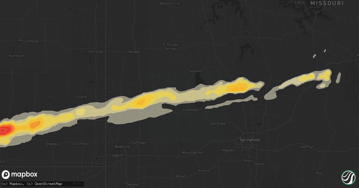
Hail Map in Cherryvale, KS on February 28, 2012
Get this storm
February 28 map
$229
one time, instant access
Download today. No call, no setup
Keep the $229
Bought the map and want the full workflow? Apply the entire $229 to a subscription within 7 days. None of it is wasted.
Every map, not just this one
This buys you this map. Subscription and you get every map we run, in the markets you choose from a few cities to whole states to nationwide. Plus real-time alerts the moment a storm fires.
Contact data
Name, contact info, occupancy, even credit band for addresses in the footprint. You go from where it hit to who to call.
Become the source they trust
Unlimited branding weather history reports on demand. You already have the documented answer ready for the property owner, and you are the one who showed up with it.
Property data and RoofTrace estimates
Pull up any address you have got, its value and the exact code rules for that jurisdiction, straight from One Click Code. Then RoofTrace estimates the squares, pitch, and roof value, priced the way you price.
Storm reports in Cherryvale, KS
Cherryvale, KS
| Date | Description |
|---|---|
| 02/27/201210:07 PM CST | 59 mph wind gusts measured at a weatherlab site. |
| 02/27/201210:05 PM CST | Hail to walnut size also occurred and windows were broken out in several homes. |
| 02/27/201210:05 PM CST | 4 to 5 inch diameter tree limbs downed. Windows also broken in homes due to wind driven hail. |
| 02/27/201210:05 PM CST | A local report indicates 3.00 inch wind near CHERRYVALE |
All States Impacted by Hail Map on February 28, 2012
All Cities Impacted by Hail Map on February 28, 2012
- Seligman, MO
- Salina, OK
- Eucha, OK
- Spavinaw, OK
- Pryor, OK
- Barnard, KS
- Minneapolis, KS
- Lincoln, KS
- Augusta, KY
- Germantown, KY
- Brooksville, KY
- Alva, OK
- Lincoln, AR
- Fayetteville, AR
- Farmington, AR
- Prairie Grove, AR
- Springdale, AR
- Nash, OK
- Medford, OK
- Wakita, OK
- Walnut Grove, MO
- Morrisville, MO
- Bolivar, MO
- Huntsville, AR
- Kingston, AR
- Harrison, AR
- Qulin, MO
- Lakeview, AR
- Gamaliel, AR
- Mammoth Spring, AR
- Cotter, AR
- Corning, AR
- Myrtle, MO
- Couch, MO
- Sturkie, AR
- Oxly, MO
- Campbell, MO
- Gassville, AR
- Yellville, AR
- Neelyville, MO
- Gatewood, MO
- Maynard, AR
- Thayer, MO
- Naylor, MO
- Henderson, AR
- Ravenden, AR
- Midway, AR
- Gepp, AR
- Broseley, MO
- Elizabeth, AR
- Pocahontas, AR
- Doniphan, MO
- Bull Shoals, AR
- Warm Springs, AR
- Viola, AR
- Success, AR
- Flippin, AR
- Mountain Home, AR
- Salem, AR
- Harviell, MO
- Bernie, MO
- Poplar Bluff, MO
- Camp, AR
- Dudley, MO
- Fisk, MO
- Turon, KS
- Canton, KS
- Moundridge, KS
- Galva, KS
- Hillsboro, KS
- Jamestown, KS
- Concordia, KS
- Norway, KS
- Belleville, KS
- Haddam, KS
- Morrowville, KS
- Mahaska, KS
- Scandia, KS
- Cuba, KS
- Narka, KS
- Old Appleton, MO
- Oak Ridge, MO
- Kevil, KY
- West Paducah, KY
- Annapolis, MO
- Fredericktown, MO
- Arcadia, MO
- Willow Springs, MO
- Pomona, MO
- Dora, MO
- West Plains, MO
- Wasola, MO
- Mountain View, MO
- Vanzant, MO
- Pottersville, MO
- Brixey, MO
- Gainesville, MO
- Winona, MO
- Ava, MO
- Zanoni, MO
- Drury, MO
- Birch Tree, MO
- Liberal, MO
- Stilwell, OK
- Welling, OK
- Proctor, OK
- Tahlequah, OK
- Ellsinore, MO
- Grandin, MO
- Van Buren, MO
- Williamsville, MO
- Fremont, MO
- Cherryvale, KS
- Golconda, IL
- Brookport, IL
- Marble Hill, MO
- Palmer, KS
- Greenleaf, KS
- Clifton, KS
- Linn, KS
- Lamar, MO
- Maple City, KS
- Dexter, KS
- Elk City, KS
- Dennis, KS
- Mound Valley, KS
- McCune, KS
- Liberty, KS
- Parsons, KS
- Independence, KS
- Arkansas City, KS
- Oswego, KS
- Sedan, KS
- Cedar Vale, KS
- Havana, KS
- Green Forest, AR
- Compton, AR
- Witter, AR
- Wesley, AR
- West Fork, AR
- Elkins, AR
- Marble Falls, AR
- Horseshoe Bend, AR
- Cherokee Village, AR
- Oxford, AR
- Hardy, AR
- Ash Flat, AR
- Shidler, OK
- Frontenac, KS
- Mindenmines, MO
- Lockwood, MO
- Saint Paul, KS
- Newkirk, OK
- Weir, KS
- Girard, KS
- Oronogo, MO
- Fair Play, MO
- Buffalo, MO
- Dadeville, MO
- Arcola, MO
- Brighton, MO
- Golden City, MO
- Coffeyville, KS
- Jasper, MO
- Half Way, MO
- Greenfield, MO
- Aldrich, MO
- Asbury, MO
- Pittsburg, KS
- Jerico Springs, MO
- Altamont, KS
- Cherokee, KS
- Herington, KS
- Burdick, KS
- Lost Springs, KS
- Lincolnville, KS
- Steele City, NE
- Odell, NE
- Diller, NE
- Jewell, KS
- Randall, KS
- Glen Elder, KS
- Beloit, KS
- Redford, MO
- Ellington, MO
- Lesterville, MO
- Centerville, MO
- Salem, MO
- Burna, KY
- Marion, KY
- Salem, KY
- Welch, OK
- Raymondville, MO
- Lebanon, MO
- Miami, OK
- Mill Spring, MO
- Alton, MO
- Jonesboro, IL
- Wolf Lake, IL
- Bunker, MO
- Cobden, IL
- Daisy, MO
- Des Arc, MO
- Cape Girardeau, MO
- Millersville, MO
- Altenburg, MO
- Burfordville, MO
- Sedgewickville, MO
- Jackson, MO
- Patton, MO
- Anna, IL
- Uniontown, MO
- Marquand, MO
- Perryville, MO
- Frohna, MO
- Friedheim, MO
- Cunningham, KS
- Arlington, KS
- Partridge, KS
- Peace Valley, MO
- Washburn, MO
- Bella Vista, AR
- Pineville, MO
- Gravette, AR
- Eagle Rock, MO
- Sulphur Springs, AR
- Cassville, MO
- Noel, MO
- Bluff City, KS
- Council Grove, KS
- Fairbury, NE
- Endicott, NE
- Hollenberg, KS
- Agenda, KS
- Munden, KS
- Courtland, KS
- Pollard, AR
- Piggott, AR
- Ghent, KY
- Vevay, IN
- Strong City, KS
- Charleston, MO
- Sikeston, MO
- Bertrand, MO
- Matthews, MO
- Essex, MO
- Dexter, MO
- Bell City, MO
- Milton, KY
- Madison, IN
- Bedford, KY
- Carrollton, KY
- Owenton, KY
- Hardinsburg, IN
- Marengo, IN
- Chester, IL
- Steeleville, IL
- Abbyville, KS
- Morganville, KS
- Miltonvale, KS
- Clyde, KS
- Harrisburg, IL
- Eldorado, IL
- Equality, IL
- Ridgway, IL
- Elkland, MO
- Long Lane, MO
- Phillipsburg, MO
- Wilsey, KS
- Florence, KS
- Marion, KS
- Mount Vernon, IN
- Lehigh, KS
- Tampa, KS
- Alto Pass, IL
- Carbondale, IL
- Makanda, IL
- Pomona, IL
- Grand Tower, IL
- Marion, IL
- Metropolis, IL
- Smithland, KY
- Peabody, KS
- Biggers, AR
- Conway, MO
- Alma, KS
- Allen, KS
- Ravenden Springs, AR
- Ferdinand, IN
- Dale, IN
- Saint Anthony, IN
- Boonville, IN
- Birdseye, IN
- Lynnville, IN
- Huntingburg, IN
- Stendal, IN
- Holland, IN
- Tennyson, IN
- Eckerty, IN
- Byars, OK
- Jay, OK
- Bucklin, MO
- Cherokee, OK
- Black Rock, AR
- Poughkeepsie, AR
- Evening Shade, AR
- Cave City, AR
- Sidney, AR
- Smithville, AR
- Braman, OK
- Ellsworth, KS
- Wilson, KS
- Stoutland, MO
- Eskridge, KS
- Datto, AR
- Brookfield, MO
- Chetopa, KS
- Kansas City, KS
- Shawnee, KS
- De Soto, KS
- Linwood, KS
- Lenexa, KS
- Bonner Springs, KS
- Parma, MO
- Amorita, OK
- Knobel, AR
- Imboden, AR
- Wiseman, AR
- Wideman, AR
- Williford, AR
- Glencoe, AR
- Berryville, AR
- Ponca, AR
- Inman, KS
- Durham, KS
- Buhler, KS
- Mcpherson, KS
- Perryville, AR
- Fair Grove, MO
- Norfork, AR
- Dolph, AR
- Calico Rock, AR
- Advance, MO
- Benton, MO
- Oran, MO
- Omaha, IL
- Junction, IL
- New Haven, IL
- Grovespring, MO
- Scammon, KS
- Columbus, KS
- Westville, OK
- Summers, AR
- Carmi, IL
- Carrier Mills, IL
- Henderson, KY
- Corydon, KY
- Pekin, IN
- Big Cabin, OK
- Adair, OK
- Taswell, IN
- Gentryville, IN
- Williamsburg, KS
- Williamstown, KY
- Falmouth, KY
- Blackwell, OK
- Nardin, OK
- South Haven, KS
- Hulbert, OK
- Muskogee, OK
- Fort Gibson, OK
- Saint Mary, MO
- Siloam Springs, AR
- Watts, OK
- Neodesha, KS
- Laquey, MO
- Falcon, MO
- Mound City, KS
- Ramona, KS
- Deer Creek, OK
- Peru, KS
- Thayer, KS
- Galesburg, KS
- Shickley, NE
- Geneva, NE
- Dover, KY
- Maysville, KY
- Puxico, MO
- Hutchinson, KS
- Alta Vista, KS
- Dwight, KS
- Lecompton, KS
- Burlington, OK
- Bradleyville, MO
- Afton, OK
- Vinita, OK
- Strang, OK
- Owensboro, KY
- Alpena, AR
- Hindsville, AR
- Rector, AR
- Broken Bow, NE
- Callaway, NE
- Hampton, KY
- Yukon, MO
- Seneca, MO
- Joplin, MO
- Neosho, MO
- Quapaw, OK
- Mountain Grove, MO
- Cabool, MO
- Houston, MO
- Paducah, KY
- Tiline, KY
- Rantoul, KS
- Ottawa, KS
- Squires, MO
- Plainview, AR
- Braymer, MO
- Medicine Lodge, KS
- Stapleton, NE
- Caldwell, KS
- La Center, KY
- Wickliffe, KY
- Graff, MO
- Black, MO
- Buncombe, IL
- Paoli, IN
- English, IN
- Mount Pleasant, AR
- Lawrence, KS
- White City, KS
- Belleview, MO
- Herod, IL
- Shawneetown, IL
- Sainte Genevieve, MO
- Eureka, KS
- Percy, IL
- Bixby, MO
- Manchester, OK
- Washington, KS
- Pleasant Hope, MO
- Noble, MO
- Everton, AR
- Everton, MO
- Ozark, IL
- Goreville, IL
- Bloomfield, MO
- Sanders, KY
- Warsaw, KY
- Delphos, KS
- Aurora, KS
- Clay Center, KS
- Eldridge, MO
- Hartshorn, MO


